| Target | Released | Hole ID | From (m) | To (m) | Intersection (m) | Au (g/t) |
| PLM | 2023-03-22 | CM23-002 | 0 | 24.4 | 24.4 | 2.22 |
| PLM | 2023-03-22 | incl. | 19.8 | 21.3 | 1.5 | 14.3 |
| PLM | 2023-03-22 | CM23-004 | 0 | 4.6 | 4.6 | 1.12 |
| PLM | 2023-03-22 | CM23-005 | 21.3 | 29.0 | 7.7 | 0.43 |
| Red Cloud | 2023-03-22 | CM23-011 | 0 | 24.4 | 24.4 | 0.54 |
| Red Cloud | 2023-03-22 | and | 35.1 | 42.7 | 7.6 | 0.6 |
| Red Cloud | 2023-03-22 | CM23-012 | 3.0 | 56.4 | 53.4 | 0.48 |
| Red Cloud | 2023-03-22 | CM23-014 | 57.9 | 64.0 | 6.1 | 0.56 |
| Red Cloud | 2023-03-22 | CM23-015 | 0 | 47.2 | 47.2 | 1.07 |
| Red Cloud | 2023-03-22 | incl. | 29.0 | 47.2 | 18.2 | 1.41 |
| Red Cloud | 2023-03-22 | and | 67.1 | 86.9 | 19.8 | 0.38 |
| Red Cloud | 2023-03-22 | and | 100.6 | 105.2 | 4.6 | 0.69 |
| Red Cloud | 2023-03-22 | CM23-016 | 12.2 | 50.3 | 38.1 | 0.67 |
| Red Cloud | 2023-03-22 | incl. | 30.5 | 42.7 | 12.2 | 1.46 |
| Red Cloud | 2023-03-22 | CM23-017 | 0 | 59.4 | 59.4 | 0.84 |
| Red Cloud | 2023-03-22 | incl. | 54.9 | 56.4 | 1.5 | 19 |
| Red Cloud | 2023-03-22 | CM23-018 | 0 | 53.3 | 53.3 | 1.37 |
| Red Cloud | 2023-03-22 | incl. | 9.1 | 32.0 | 22.9 | 2.44 |
| Red Cloud | 2023-03-22 | and | 77.7 | 83.8 | 6.1 | 0.44 |
| Red Cloud | 2023-03-22 | CM23-019 | 0 | 67.1 | 67.1 | 0.59 |
| Red Cloud | 2023-03-22 | CM23-020 | 54.9 | 61.0 | 6.1 | 2 |
| Red Cloud | 2023-03-22 | CM23-022 | 4.6 | 62.5 | 57.9 | 1.82 |
| Red Cloud | 2023-03-22 | incl. | 10.7 | 25.9 | 15.2 | 4.12 |
| Red Cloud | 2023-03-22 | incl. | 41.1 | 48.8 | 7.7 | 3.52 |
| Red Cloud | 2023-03-22 | CM23-023 | 16.8 | 68.6 | 51.8 | 0.45 |
| Red Cloud | 2023-03-22 | CM23-024 | 0 | 44.2 | 44.2 | 0.88 |
| Red Cloud | 2023-03-22 | incl. | 25.9 | 33.5 | 7.6 | 1.92 |
| Red Cloud | 2023-03-22 | CM23-025 | 0 | 50.3 | 50.3 | 1.35 |
| Red Cloud | 2023-03-22 | incl. | 16.8 | 36.6 | 19.8 | 2.55 |
| Red Cloud | 2023-03-22 | CM23-026 | 0 | 56.4 | 56.4 | 0.37 |
| Red Cloud | 2023-03-22 | CM23-028 | 10.7 | 36.6 | 25.9 | 0.36 |
| Red Cloud | 2023-03-22 | CM23-029 | 0 | 42.7 | 42.7 | 2.44 |
| Red Cloud | 2023-03-22 | incl. | 21.3 | 39.6 | 18.3 | 5.53 |
| Red Cloud | 2023-03-22 | incl. | 21.3 | 27.4 | 6.1 | 11.72 |
| Red Cloud | 2023-04-27 | CM23-030 | 16.8 | 54.9 | 38.1 | 0.43 |
| Red Cloud | 2023-04-27 | incl. | 16.8 | 30.5 | 13.7 | 0.95 |
| Red Cloud | 2023-04-27 | CM23-031 | 64.0 | 67.1 | 3.0 | 1.84 |
| Red Cloud | 2023-04-27 | and | 88.4 | 103.6 | 15.2 | 0.54 |
| Stealth | 2023-04-27 | CM23-038 | 33.5 | 47.2 | 13.7 | 0.50 |
| Gap Zone | 2023-04-27 | CM23-040 | 45.7 | 50.3 | 4.6 | 1.40 |

Gold Basin Resources (TSXV:GXX) announced on April 27 significant progress in their 2023 Phase 2 Resource Definition Drill Program at the company’s wholly-owned Gold Basin oxide gold project located in northwestern Arizona. The second phase saw the completion of 41 RC drill holes, amounting to a total of 5,004.8 meters, focusing on resource definition at the Red Cloud (24 holes), PLM (10 holes), Stealth (7 holes) sites, and portions of the undrilled gap between Red Cloud and Stealth.
Colin Smith, CEO of Gold Basin commented in a press release: “Results from Gold Basin’s first drill program at Red Cloud confirm the presence of an at-surface, high-grade oxide gold system analogous to Stealth which remains largely open for expansion. We are currently mobilizing a highly portable track-mounted RC rig back to site for 2,000 metres of follow-up drilling, testing the open southeasterly strike. This trend is supported by favorable geophysical and geochemical signatures, including 25.3 g/t Au and 16.6 g/t Au rock samples, located 150 metres and 950 metres along-strike, respectively, from Red Cloud.”
Out of the 41 holes drilled, 36 have yielded near-surface oxide gold intercepts, with 13 holes showing gram*metre values exceeding 20 and 7 holes surpassing 50. A comprehensive summary of significant Phase 2 oxide gold assays can be found in Table 1.
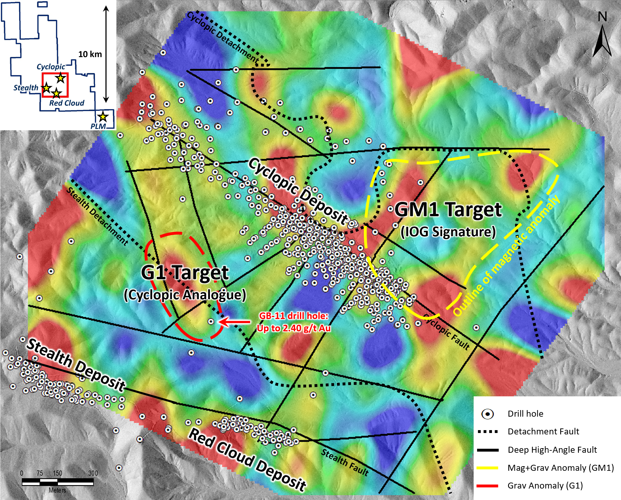
In addition to the drilling program, a 2 km by 2 km ground gravity survey was conducted in March 2023, encompassing the Cyclopic, Red Cloud, and Stealth Deposits. The survey aimed to assess the density signature of established gold systems at Gold Basin and detect the presence of proximal untested analogues. Distinct density (gravity) anomalies were observed at all three gold deposits, leading to the identification of two highly prospective drill targets – a Cyclopic analogue (“G1”) and a deeper IOG target (“GM1”) (see Figure 1).
The G1 target, positioned equidistant between the Cyclopic and Stealth Deposits, showcases a similar exploration signature and structural model to the known gold deposits at Gold Basin. The identification of new high-angle feeder structures intersecting the gold-bearing Cyclopic Detachment Fault, together with a strong 300-m-long density anomaly akin to the Cyclopic Deposit, signal potential at the G1 target. While shallow alluvial cover masked these structures and associated surficial geochemical response, a historical drill hole near the southeastern margin of G1 encountered up to 2.40 g/t Au at 47.2 meters down-hole. The G1 target is scheduled for testing in the upcoming 2,000-meter follow-up RC drill program.
The GM1 target, a deeper untested IOG target, is associated with a 500-meter-diameter density anomaly and a strongly magnetic zone detected in the 2021 droneborne magnetics survey. The magnetic anomaly is believed to signify disseminated magnetite alteration since the 2022 IP survey indicated a low pyrite concentration. All these physical traits are characteristic of IOG systems, making the GM1 target a suitable candidate for a deeper core drilling program planned for Q3 or Q4 2023.
Highlights from the program are as follows:
- All assays received from Phase 2 reverse-circulation (“RC”) drill program, with 11 of the final 12 drill holes at the Red Cloud and Stealth targets intercepting oxide gold at vertical depths ranging from 4.6 metres (“m”) to 182.9 m down-hole;
- Multiple holes, including the deepest hole in the program (CM-23-040 drilled to 182.9 m in Gap Zone) ended in oxide gold mineralization, suggesting a second untested mineralized detachment plane is present at depth;
- Red Cloud and Stealth remain open along strike to the northwest and southeast, and both 2023 drill holes testing the Gap Zone between the two targets returned gold assays, including 1.40 g/t Au over 4.6 m from 45.7 m in drill hole CM23-040, suggesting mineralized continuity along the entire 1.2 kilometre (“km”) strike extent drilled to date;
- Track-mounted “Grasshopper” RC drill rig currently mobilizing to Gold Basin for 2,000 metres of priority follow-up drilling given the highly successful Phase 2 program, testing the open southeasterly strike at Red Cloud;
- March 2023 ground gravity survey conducted over Cyclopic, Red Cloud and a portion of Stealth defined two additional high-priority drill targets:
- Shallow Cyclopic analogue target equidistant between Cyclopic and Stealth, undetected by previous conventional exploration due to shallow alluvial cover – may be tested in the 2,000 metre follow-up program
- Deeper Iron Oxide Gold (“IOG”) target underneath Cyclopic which hosts strong coincident density and magnetic anomalies – to be tested later in Q3 or Q4 2023 by deeper core drilling.
The above references an opinion and is for information purposes only. It is not intended to be investment advice. Seek a licensed professional for investment advice. The author is not an insider or shareholder of any of the companies mentioned above.
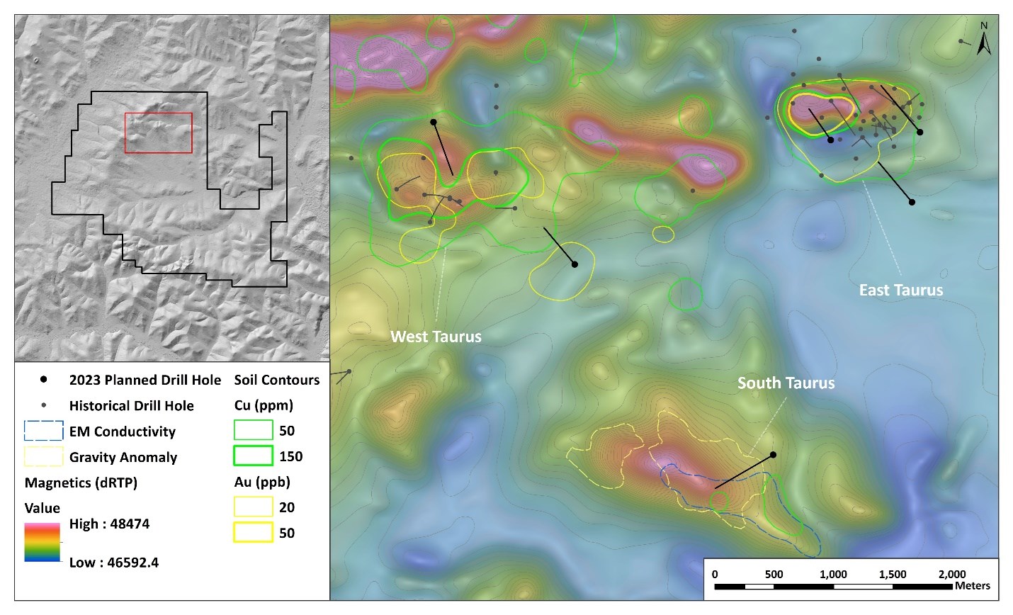
Kenorland Minerals (TSXV: KLD) has unveiled its ambitious 2023 exploration program and budget for the Tanacross Project, which is situated in eastern Alaska and operates under an earn-in agreement with Antofagasta Minerals S.A., a wholly-owned subsidiary of Antofagasta PLC (LSE: ANTO).
This summer, Kenorland will be conducting an extensive drill program, which will involve up to 4,500 meters of diamond drilling. The primary target areas for this operation include East Taurus, West Taurus, and South Taurus. The budget for the drill program is set at around US$3.8 million, and the drilling activities will take place from June to August.
The upcoming drill program is preceded by surface work carried out last summer, which encompassed the collection of 800 infill soil samples, detailed IP and MT surveys along the West Taurus-McCord Creek-East Taurus trend, and ELF (EM) and ground gravity surveys focusing on the South Taurus anomaly.
As part of the agreement, Antofagasta has the opportunity to acquire a 70% interest in Tanacross by making cash payments totaling US$1,000,000 and a success payment of US$4,000,000 upon the exercise of the option. Additionally, they must commit to spending US$30,000,000 on exploration over an eight-year period, with a firm pledge of US$1,000,000 in the first year. A preliminary economic assessment supported by a technical report, as defined in NI 43-101, must also be delivered. Throughout the option period, Antofagasta will finance all exploration efforts, while Kenorland will act as the initial operator.
Once Antofagasta acquires its 70% interest, a 30:70 joint venture between Kenorland and Antofagasta will be formed. If either party’s interest drops below 10%, their share will be converted to a 2% NSR. The other party can then purchase one quarter of this interest for US$2,000,000.
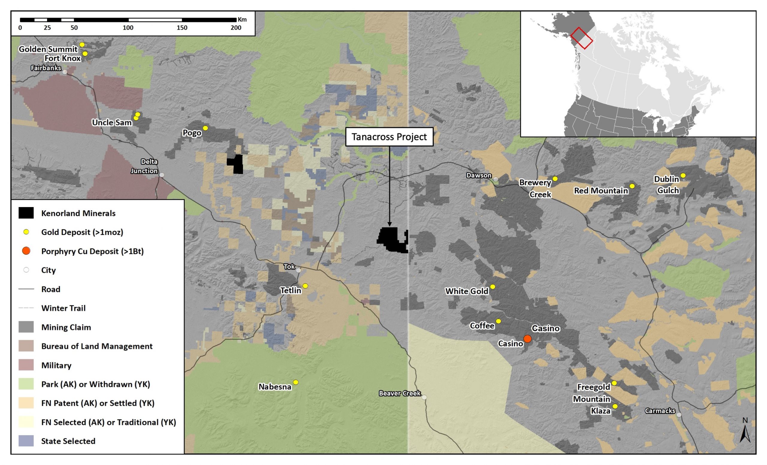
Located 70 kilometers northeast of Tok, along the Alaska Highway, the Tanacross Project spans 45,000 hectares of state-owned land. Hosting a group of late Cretaceous (68-73Ma) porphyry copper (+/- gold, molybdenum) occurrences, the project features East Taurus, West Taurus, and Bluff. The age of mineralization in the project is akin to the massive Casino porphyry copper system (Western Copper and Gold Corp.), which is situated 140 kilometers southeast in Yukon Territory, Canada, and the Tetlin Au Skarn system (Contango Ore Inc.), 70 kilometers southwest of the Tanacross Project.
Since the discovery of East Taurus in 1971 by Duval Corporation, the Tanacross Project has experienced a total of 17,076 meters of drilling across over 67 drill holes. Nine different companies have conducted multiple drill campaigns, with the latest drill program in 2019 under option to Freeport-McMoRan. The project’s most impressive historical results occurred at East Taurus, where drill hole 08DDH040 intersected 232.56 meters at 0.31% Cu, 0.25 g/t Au, and 0.036% Mo.
The above references an opinion and is for information purposes only. It is not intended to be investment advice. Seek a licensed professional for investment advice. The author is not an insider or shareholder of any of the companies mentioned above.
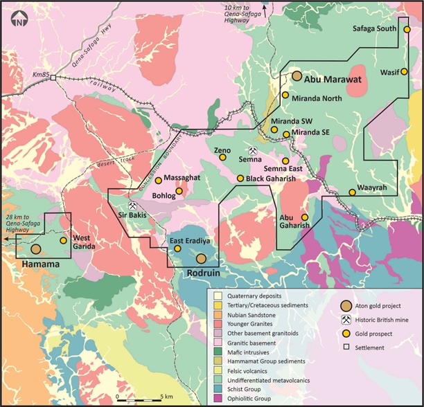
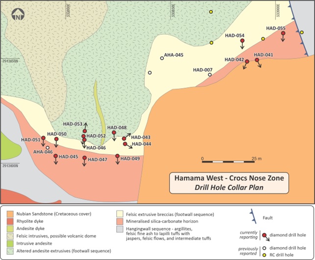
Aton Resources Inc. (TSXV:AAN) has announced the final assay results from its latest diamond drilling program at the Hamama site, situated within the company’s wholly-owned Abu Marawat Concession in Egypt’s Eastern Desert (Figure 1). The drilling initiative at Hamama resumed in mid-January 2023 and concluded on March 11, 2023, during which a total of 1,612.7 meters were drilled.
Tonno Vahk, Interim CEO, commented in a press release: “These final results from the Crocs Nose exceeded expectations, and we are very pleased with them. The Crocs Nose Zone represents a structural offset of the main mineralised zone at Hamama West and was not included in the 2017 mineral resource estimate. The grades intersected in this programme are notably higher than the overall grade of the Hamama West oxide resource, and this zone should be a nice sweetener to the planned starter open pit mining operation at Hamama. We are also pleased to have now signed the RC drilling contract with Geodrill and look forward to starting the drilling at West Garida in May. We believe there is good potential to rapidly add significant near-surface ounces from the high-grade quartz veins we drilled at West Garida last summer to the overall resource base at Hamama.”
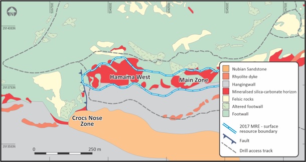
Hamama’s mineralization is contained within a stratiform silica-carbonate horizon (SCMH) that spans approximately 3.2 kilometres in strike length and varies in thickness. At Hamama West, the SCMH exceeds 60 meters in thickness in certain areas, presenting iron oxide-rich and gossanous characteristics at the surface and throughout the oxide zone. The 2023 Hamama diamond drilling program involved drilling 15 shallow holes (HAD-041 to HAD-055) at the CNZ, totaling 545.8 meters (refer to Table 1 and Figure 3). The final assay results from these latest holes are now accessible.
The CNZ mineralization seems to be situated in a faulted offset of the primary mineralized zone at Hamama West (Figures 2 and 3). This fault offsets the SCMH sinistrally by approximately 150 meters to the south, terminating the outcropping mineralization to the west. At CNZ, this fault serves as the footwall of the mineralized block, while at Hamama West, the mineralization continues along strike to the west beneath this structure. Recent intersections at Hamama West include 1.57 g/t Au, 29.99 g/t Ag, and 1.92 AuEq over a 47-meter interval, starting from a 26-meter depth (hole HAP-192, as reported in the October 20, 2022 news release). The CNZ mineralization was not accounted for in the initial Hamama West mineral resource estimate (refer to the January 24, 2017 news release).
The SCMH-hosted mineralization at CNZ is visible on the surface along the northern and western edges of the Cretaceous Nubian Sandstone (NS) outlier, which unconformably overlies the Neoproterozoic rocks containing the Hamama mineralization (Figure 3). Surface trenching of the unconformity has clearly demonstrated that the mineralization extends underneath and immediately below the NS outlier.
Past diamond drilling at CNZ has yielded intersections such as 2.46 g/t Au, 157.3 g/t Ag, and 4.73 g/t AuEq over a 19-meter interval from a 12-meter depth (hole AHA-046, as reported in the June 9, 2015 news release, and Figure 3), 2.05 g/t Au, 168.9 g/t Ag, and 4.48 g/t AuEq over a 12-meter interval from a 27-meter depth (hole AHA-045, also reported in the June 9, 2015 news release), and 1.65 g/t Au, 82.7 g/t Ag, and 1.92 g/t AuEq over a 28-meter interval from a 7-meter depth (hole HAD-007, as reported in the May 18, 2017 news release). Earlier surface trenching at CNZ also revealed outcropping mineralization at the surface, including 3.47 g/t Au, 118.2 g/t Ag, and 5.35 g/t AuEq over a 26-meter width.
Highlights from the results are as follows:
- A total of 545.8 metres was drilled from 15 shallow holes at the Crocs Nose Zone (“CNZ”) at Hamama West, completing the short Hamama 2023 diamond drilling programme. The programme was designed to test for potential near-surface oxide gold-silver mineralisation that had been previously intersected in a limited number of holes;
- Results from the programme included the following mineralised intersections:
- 1.57 g/t Au, 230.6 g/t Ag, and 4.28 g/t Au equivalent (“AuEq”), over an interval of 20.78m from 12.66m downhole depth (HAD-054);
- 1.84 g/t Au, 62.20 g/t Ag, and 2.57 g/t AuEq, over an interval of 24.55m from 6.45m downhole depth (HAD-052);
- 1.37 g/t Au, 52.81 g/t Ag, and 1.99 g/t AuEq, over an interval of 34.80m from 2.00m downhole depth (HAD-042);
- 1.63 g/t Au, 7.01 g/t Ag, and 1.71 g/t AuEq, over an interval of 16.30m from surface (HAD-049), and;
- 1.23 g/t Au, 41.01 g/t Ag, and 1.72 g/t AuEq, over an interval of 18.90m from 0.80m downhole depth (HAD-045);
- Preparations are well underway for the upcoming RC exploration drilling programme, with drilling expected to commence within the first fortnight of May at West Garida.
| Hole ID | Collar co-ordinates 1 | Dip 2 | Grid azimuth 2 | EOH depth (m) | Comments | ||
| X | Y | Z | |||||
| HAD-041 | 533891.2 | 2913649.4 | 515.4 | -30.6 | 153.9 | 36.1 | CNZ (north side, under NS) |
| HAD-042 | 533886.5 | 2913648.5 | 515.4 | -33.1 | 204.1 | 42.0 | CNZ (north side, under NS) |
| HAD-043 | 533827.8 | 2913611.6 | 508.9 | -0.7 | 51.6 | 98.6 | CNZ (west side, under NS) |
| HAD-044 | 533828.3 | 2913609.2 | 508.6 | -10.2 | 120.1 | 46.0 | CNZ (west side, under NS) |
| HAD-045 | 533795.1 | 2913603.4 | 506.9 | -65.3 | 178.6 | 30.0 | CNZ (west side) |
| HAD-046 | 533808.9 | 2913611.1 | 506.5 | -44.9 | 181.3 | 31.4 | CNZ (west side) |
| HAD-047 | 533809.0 | 2913602.6 | 507.2 | -43.6 | 182.4 | 26.1 | CNZ (west side) |
| HAD-048 | 533823.1 | 2913614.7 | 507.3 | -44.2 | 177.6 | 29.4 | CNZ (west side) |
| HAD-049 | 533824.7 | 2913603.4 | 507.6 | -43.9 | 178.7 | 22.3 | CNZ (west side) |
| HAD-050 | 533795.6 | 2913611.5 | 506.2 | -69.3 | 182.1 | 36.1 | CNZ (west side) |
| HAD-051 | 533789.3 | 2913612.1 | 505.7 | -69.4 | 179.8 | 19.6 | CNZ (west side) |
| HAD-052 | 533808.5 | 2913612.8 | 506.5 | -69.8 | 187.1 | 36.9 | CNZ (west side) |
| HAD-053 | 533809.0 | 2913615.2 | 506.4 | -74.4 | 8.4 | 41.3 | CNZ (west side) |
| HAD-054 | 533884.3 | 2913658.5 | 515.0 | -44.6 | 181.5 | 35.1 | CNZ (north side, under NS) |
| HAD-055 | 533903.7 | 2913662.1 | 514.0 | -44.6 | 182.3 | 14.9 | CNZ (north side) |
Notes:
|
|||||||
Table 1: Collar details of diamond drill holes HAD-041 to HAD-055
The recent drilling has confirmed the presence of outcropping gold-silver mineralisation at the CNZ, with all holes intersecting mineralisation, as expected. Details of all mineralised intersections are provided in Table 2, and selected intersections are shown below:
- HAD-054: 1.57 g/t Au, 230.6 g/t Ag, and 4.28 g/t AuEq, over a 20.78m interval, from 12.66m depth
- HAD-052: 1.84 g/t Au, 62.2 g/t Ag, and 2.57 g/t AuEq, over a 24.55m interval, from 6.45m depth
- HAD-042: 1.37 g/t Au, 52.81 g/t Ag, and 1.99 g/t AuEq, over a 34.80m interval, from 2.00m depth
- HAD-049: 1.63 g/t Au, 7.01 g/t Ag, and 1.71 g/t AuEq, over a 16.30m interval, from surface
- HAD-045: 1.23 g/t Au, 41.01 g/t Ag, and 1.72 g/t AuEq, over an 18.90m interval, from 0.80m depth
| Hole ID | Intersection (m) 1 | Au (g/t) | Ag (g/t) | AuEq (g/t) 2 | Cu (%) | Pb (%) | Zn (%) | Comments 3 | ||
| From | To | Interval | ||||||||
| HAD-041 | 2.00 | 15.80 | 13.80 | 1.50 | 72.70 | 2.36 | 0.01 | 0.02 | 0.01 | |
| HAD-042 | 2.00 | 36.80 | 34.80 | 1.37 | 52.81 | 1.99 | 0.01 | 0.03 | 0.04 | |
| HAD-043 | 31.50 | 54.30 | 22.80 | 0.89 | 4.67 | 0.95 | 0.01 | 0.02 | 0.02 | includes 0.3m of core loss |
| and | 70.35 | 85.95 | 15.60 | 0.52 | 54.49 | 1.16 | 0.01 | 0.01 | 0.02 | |
| HAD-044 | 6.80 | 23.85 | 17.05 | 0.52 | 13.08 | 0.67 | 0.02 | 0.03 | 0.03 | |
| and | 28.95 | 31.15 | 2.20 | 1.78 | 28.95 | 2.12 | 0.01 | 0.01 | 0.05 | |
| HAD-045 | 0.80 | 19.70 | 18.90 | 1.23 | 41.01 | 1.72 | 0.01 | 0.31 | 0.04 | includes 1.3m of core loss |
| HAD-046 | 12.60 | 23.70 | 11.10 | 0.47 | 37.25 | 0.91 | 0.01 | 0.37 | 0.02 | includes 7.2m of core loss |
| HAD-047 | 0.00 | 6.40 | 6.40 | 1.00 | 67.67 | 1.80 | 0.01 | 0.04 | 0.03 | |
| HAD-048 | 0.00 | 17.35 | 17.35 | 0.75 | 54.98 | 1.39 | 0.06 | 0.45 | 0.02 | includes 2.2m of core loss |
| HAD-049 | 0.00 | 16.30 | 16.30 | 1.63 | 7.01 | 1.71 | 0.01 | 0.04 | 0.04 | includes 3.2m of core loss |
| HAD-050 | 1.45 | 11.45 | 10.00 | 0.28 | 6.27 | 0.35 | 0.18 | 0.03 | 2.48 | |
| HAD-051 | – | – | – | – | – | – | – | – | – | Not assayed 4 |
| HAD-052 | 6.45 | 31.00 | 24.55 | 1.84 | 62.20 | 2.57 | 0.03 | 0.50 | 0.11 | includes 5.7m of core loss |
| HAD-053 | 13.52 | 18.70 | 5.18 | 0.61 | 21.35 | 0.87 | 0.44 | 2.61 | 2.16 | |
| HAD-054 | 12.66 | 33.44 | 20.78 | 1.57 | 230.6 | 4.28 | 0.01 | 0.02 | 0.01 | includes 2.9m of core loss |
| HAD-055 | 0.00 | 5.81 | 5.81 | 1.88 | 18.22 | 2.09 | 0.01 | 0.02 | 0.03 | |
Notes:
|
||||||||||
Table 2: Mineralised intersections from the Crocs Nose Zone (Hamama West)
The above references an opinion and is for information purposes only. It is not intended to be investment advice. Seek a licensed professional for investment advice. The author is not an insider or shareholder of any of the companies mentioned above.
Horizonte Minerals (TSX: HZM) has announced that its Araguaia nickel mine in northern Brazil is on schedule to commence production in Q1 2024. The mining company started constructing the operation in May of the previous year and, as of March 30, reported that Araguaia Line 1 is 50% complete.
Chief Executive of Horizonte, Jeremy Martin, commented in a statement: “With the award of the Line 2 Feasibility Study contracts, we are one step closer to delivering on this low capex project that will double nickel production.”
The main Pequizeiro pit has already seen the initiation of pre-stripping activities, with ore stockpiling expected to begin in Q3 of this year. Horizonte has allocated about 90% of the capital expenditure, approximately $485 million, for the project.
Purchased from Glencore in 2015, the Araguaia mine is projected to initially produce 14,500 tonnes of nickel per annum, primarily catering to the stainless steel market. The production rate is anticipated to increase to 29,000 tonnes annually once the second production line becomes operational in 2027.
The Araguaia mine is crucial for diversifying Brazil’s mining sector, which is predominantly focused on iron ore. With estimated reserves of 16 million tonnes of nickel, Brazil ranks as the world’s eighth-largest producer. According to GlobalData, the country’s output increased by 8% to 108,000 tonnes in 2022 compared to the previous year.
Iron, the world’s most widely used metal, plays a crucial role in a variety of industries, particularly in manufacturing and construction. It is the primary raw material for steel production, which is indispensable for infrastructure development, transportation, and the production of various consumer goods. The iron market’s health is closely tied to the global economy and has a direct impact on numerous sectors.
China, the world’s largest consumer of iron ore, significantly influences the iron market. With its rapid economic growth and urbanization, the country has experienced a surge in demand for steel to support its expanding infrastructure projects, such as high-speed rail networks, bridges, and skyscrapers. This has led to a substantial increase in China’s consumption of iron ore and consequently, its impact on global iron prices and demand from miners.
The above references an opinion and is for information purposes only. It is not intended to be investment advice. Seek a licensed professional for investment advice. The author is not an insider or shareholder of any of the companies mentioned above.
Prismo Metals (CSE: PRIZ) (OTCQB: PMOMF) has reported positive assay results from its extensive exploration of the 5,289-hectare (20 square miles) Los Pavitos project, situated in the mineral-rich Alamos region of southern Sonora State, Mexico. The most promising findings were observed at the Las Auras and Santa Cruz target areas, where numerous gold assays exceeded 3 grams per ton (g/t) over widths ranging from 0.15 to 1.5 meters.
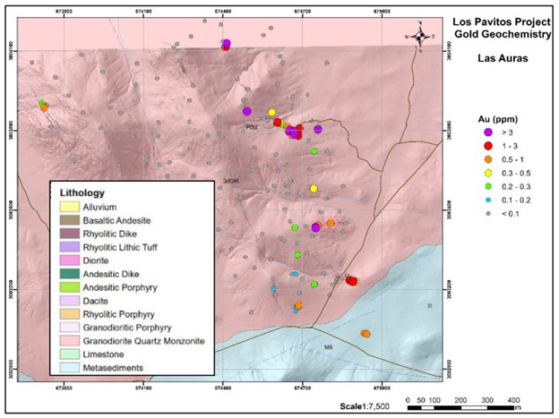
The Las Auras target area delivered particularly impressive results, with the highest gold concentration reaching 14.35 g/t over 0.5 meters, and 12.25 g/t over a 1-meter width in two distinct locations. At the Santa Cruz target, ongoing sampling also revealed notable gold and silver values. The best results featured 5.48 g/t gold and 269 g/t silver over a 0.5-meter width, while another sample displayed 543 g/t silver and 1 g/t gold over 1.5 meters.
The most recent phase of systematic mapping and sampling focused on the Las Auras target, where 199 samples were collected. Additionally, follow-up sampling at Santa Cruz saw the completion of 94 samples. Out of the 293 samples, forty-nine yielded gold concentrations of 0.5 g/t or higher, and eleven samples also contained over 100 g/t silver. The pathfinder elements arsenic (As) and bismuth (Bi) were generally found to be strongly anomalous.
Dr. Craig Gibson, President and CEO of Prismo Metals, commented in a press release: “We are very pleased to see high-grade gold results emerge from our detailed sampling program at Las Auras along with continued high gold and local silver from Santa Cruz. The two areas are different; Las Auras is characterized by northwest trending veins and shears hosted in intrusions, while Santa Cruz is dominated by northeast trending veins that follow sedimentary bedding. Both areas have significant soil cover and trenching will help trace the structures and determine the full width of the mineralized areas”.
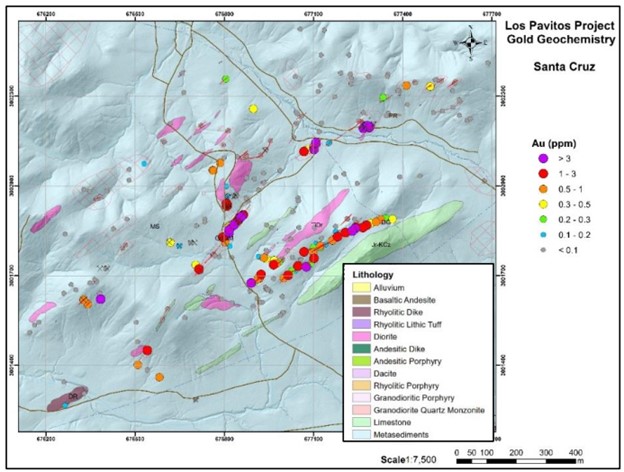
Table 1. Highlight assays from the Las Auras area
| Sample | Type | Style | Width (m) | Easting | Northing | Au_g/t | Ag g/t | As_ppm | Bi_ppm | |||||||
| 12092 | Chip | Vein | 0.5 | 674653 | 3003803 | 9.4 | 17.75 | 1155 | 10.7 | |||||||
| 12093 | Chip | 0.65 | 674655 | 3003805 | 0.673 | 2.33 | 1040 | 12.55 | ||||||||
| 12094 | Chip | Vein | 0.2 | 674660 | 3003799 | 2.38 | 9.27 | 891 | 0.46 | |||||||
| 12095 | Chip | 0.6 | 674661 | 3003781 | 0.539 | 8.37 | 183 | 11.55 | ||||||||
| 12096 | Chip | 0.5 | 674667 | 3003797 | 5.83 | 14.65 | >10000 | 3.15 | ||||||||
| 12097 | Chip | 0.6 | 674670 | 3003796 | 1.06 | 2.86 | 1390 | 1.74 | ||||||||
| 12098 | Chip | Vein | 0.15 | 674669 | 3003796 | 3.84 | 4.26 | >10000 | 9.01 | |||||||
| 12115 | Chip | Vein | 0.15 | 674673 | 3003795 | 0.583 | 1.1 | 4070 | 4.92 | |||||||
| 12116 | Chip | Area | 0.6 | 674670 | 3003786 | 6.43 | 4.74 | >10000 | 8.53 | |||||||
| 12117 | Chip | Area | 0.6 | 674685 | 3003782 | 1.25 | 1.65 | 4550 | 1.48 | |||||||
| 12121 | Chip | Vetilla | 0.6 | 674643 | 3003815 | 0.599 | 1.92 | 1670 | 0.53 | |||||||
| 12124 | Chip | Vein | 0.15 | 674606 | 3003830 | 1.19 | 1.73 | 6200 | 4.32 | |||||||
| 12125 | Chip | Disseminated | 0.6 | 674606 | 3003831 | 1.85 | 3.29 | 887 | 1.16 | |||||||
| 12163 | Chip | Area | 1 | 674491 | 3003873 | 3.85 | 5.96 | 5270 | 8.5 | |||||||
| 12165 | Chip | Vetilla | 1.5×2.5×1 | 674414 | 3004129 | 12.25 | 47.3 | 2290 | 16.1 | |||||||
| 12196 | Chip | Area | 1 | 673725 | 3003886 | 0.563 | 1.72 | 493 | 5.02 | |||||||
| 12209 | Chip | Vetilla | 0.4 | 674807 | 3003451 | 0.74 | 42.7 | 6780 | 137 | |||||||
| 12210 | Chip | Vetilla | 0.5 | 674758 | 3003443 | 0.555 | 4.77 | 3880 | 7.69 | |||||||
| 12211 | Chip | Vetilla | 0.5 | 674750 | 3003433 | 14.35 | 52.7 | 5630 | 14.3 | |||||||
| 12217 | Chip | Skarn | 0.6 | 674684 | 3003137 | 0.551 | 89.7 | >10000 | 25.6 | |||||||
| 12218 | Chip | Skarn | 0.6 | 674685 | 3003137 | 0.739 | 8.18 | >10000 | 11.95 | |||||||
| 12219 | Chip | Skarn | 0.6 | 674686 | 3003142 | 0.716 | 224 | >10000 | 0.39 | |||||||
| 12251 | Chip | Vein | 0.25 | 674881 | 3003235 | 1.31 | 0.95 | 8190 | 3.22 | |||||||
| 12252 | Chip | Area | 1 | 674879 | 3003236 | 1.2 | 1.31 | 5510 | 2.19 | |||||||
| 12253 | Chip | Vein | 0.25 | 674877 | 3003235 | 0.771 | 1.32 | 6340 | 4.17 | |||||||
| 12255 | Chip | Vein | 0.4 | 674893 | 3003232 | 2.24 | 10.05 | >10000 | 7.22 | |||||||
| 12256 | Chip | Vein | 0.4 | 674887 | 3003234 | 0.829 | 9.26 | 3810 | 1.08 | |||||||
| 12257 | Chip | Area | 1 | 674889 | 3003230 | 1.47 | 4.8 | 8140 | 2.15
|
|||||||
Table 2. Highlight assays from the Santa Cruz area
| Sample | Type | Style | Width (m) | Easting | Northing | Au_g/t | Ag g/t | As_ppm | Bi_ppm |
| 12289 | Chip | Breccia | 0.5 | 677099 | 3001780 | 0.67 | 46.5 | >10000 | 0.67 |
| 12293 | Chip | Area | 1 | 677243 | 3001862 | 1.98 | 72.6 | >10000 | 0.54 |
| 12305 | Chip | Area | 2 | 676715 | 3001722 | 1.89 | 3.37 | 652 | 0.6 |
| 12314 | Chip | Vein | 1.5 | 676966 | 3001737 | 1.42 | 64.2 | >10000 | 3.37 |
| 12315 | Chip | Vein | 1.5 | 676977 | 3001741 | 0.876 | 329 | >10000 | 1.69 |
| 12323 | Chip | Vein | 1.5 | 676924 | 3001704 | 1.01 | 542 | >10000 | 0.97 |
| 12327 | Chip | Vein | 1.5 | 676891 | 3001676 | 5.14 | 88.1 | >10000 | 5.05 |
| 12330 | Chip | Vein | 1 | 676934 | 3001760 | 0.707 | 447 | 3030 | 4.5 |
| 12349 | Chip | Vein | 1.8 | 677015 | 3001702 | 1.07 | 37.1 | 5640 | 0.55 |
| 12359 | Chip | Vein | 0.5 | 677240 | 3001858 | 3.08 | 295 | >10000 | 0.73 |
| 12361 | Chip | Vein | 0.5 | 677231 | 3001850 | 5.48 | 269 | >10000 | 0.11 |
| 12384 | Chip | Vein | 0.5 | 677327 | 3001888 | 0.869 | 35.3 | 8860 | 0.06 |
| 12385 | Chip | Vein | 0.5 | 677311 | 3001880 | 0.872 | 7.58 | >10000 | 0.21 |
| 12387 | Chip | Vein | 0.5 | 677279 | 3001869 | 1.95 | 70.2 | 6360 | 0.2 |
| 12388 | Chip | Vein | 0.5 | 677266 | 3001861 | 2.24 | 181 | >10000 | 1.84 |
| 12389 | Chip | Vein | 0.5 | 677208 | 3001844 | 2.62 | 326 | >10000 | 0.72 |
| 12391 | Chip | Vein | 0.5 | 677181 | 3001831 | 1.5 | 54.5 | >10000 | 0.68 |
| 12393 | Chip | Vein | 0.5 | 677164 | 3001818 | 0.654 | 21.9 | 4010 | 0.23 |
| 12395 | Chip | Vein | 0.5 | 677123 | 3001800 | 0.533 | 184 | 9790 | 1.02 |
| 12397 | Chip | Vein | 0.5 | 677076 | 3001730 | 3.15 | 398 | >10000 | 5.48 |
| 12398 | Chip | Vein | 0.5 | 677000 | 3001692 | 0.645 | 8.81 | 4400 | 0.58 |
The above references an opinion and is for information purposes only. It is not intended to be investment advice. Seek a licensed professional for investment advice. The author is not an insider or shareholder of any of the companies mentioned above.
Vital Metals (ASX:VML), the Australian-based rare earths producer, has announced a pause in the construction of its Saskatoon processing facility, which is the only rare earths processing facility in Canada. The company has cited concerns over the economic viability of its plans to market an intermediate product from the plant as the main reason for the pause.
Before the trading halt on April 18th, shares in Vital Metals were down by more than a quarter, falling to A1.1¢ on the ASX, leading to a market cap of A$43.8 million. The shares have traded between A1¢ and A7.2¢ over the past year.
In a release on Wednesday, Vital Metals stated that it was not able to sell its intermediate REE product “on commercially satisfactory terms”. The company pinpointed both higher plant costs and lower rare earth prices as factors in its decision to pause plant construction.
Vital Metals’ interim chairman, Richard Crookes, said that “there is no economic imperative to complete this demonstration project at the current time.” He added that the Saskatoon processing facility could provide valuable intermediate processing capacity for a downstream rare earth hub in Saskatchewan. He further noted that North America needs independent downstream processing to further enable the transition to the green economy, and Vital is looking forward to working with like-minded parties to deliver a completed project.
The company has also said that it is now completing a three-month strategic review of the plant while it seeks out new funding sources and partnerships with third parties to “build a sustainable business model”. In December 2021, Vital Metals had previously announced that it would slow down construction of the plant as costs to complete it had doubled to around C$55 million.
At the time, the company said it would defer completion of the plant to the second half of 2024 when its offtake customer REEtec would be ready to receive product for further processing at its plant, now under construction in Norway. Vital had also said that putting on hold the hydrometallurgical leaching, purification, and rare earth precipitation circuits would save it nearly C$16 million. However, the company had stated that it would still finish the calcine circuit at the plant by the third quarter of 2023 in order to produce an intermediate rare earth oxide product.
The recent decline in rare earths prices has also played a significant role in Vital Metals’ decision. According to a recent edition of the newsletter Critical Metals for a Sustainable World, rare earths prices “plunged” in March and early April based on China’s slowing economy and modest growth forecasts. The Apr. 17 report said prices for light rare earths are the lowest they’ve been since late 2020 or early 2021.
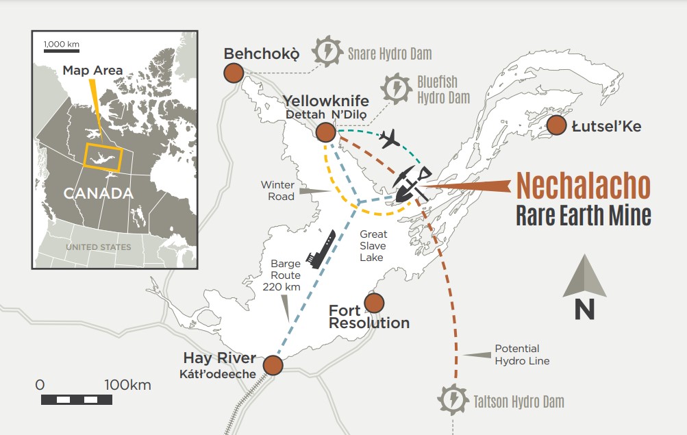
Despite the pause in construction, Vital Metals recently completed a drill program of more than 6,600 metres at its Tardiff deposit, with assay results and a resource update expected in the second half of the year. Vital has the rights to the near-surface Tardiff zones of the Nechalacho deposit, located 110km southeast of Yellowknife. Vital’s Yellowknife-based subsidiary, Cheetah Resources, began mining at the site, which is permitted for demonstration-scale production, in June 2021. Avalon Advanced Materials (TSX: AVL) holds the rights to mineralization below 150 metres at the project.
According to a February resource update, Tardiff contains 4.6 million measured tonnes at 1.6% total rare earth oxides (TREO), including 0.31% neodymium oxide and 0.08% praseodymium oxide; 6.3 million indicated tonnes at 1.5% TREO; and 108.1 million inferred tonnes at 1.
The above references an opinion and is for information purposes only. It is not intended to be investment advice. Seek a licensed professional for investment advice. The author is not an insider or shareholder of any of the companies mentioned above.
Talon Metals Corp. (TSX: TLO), the majority owner and operator of the Tamarack Nickel-Copper-Cobalt Project located in central Minnesota, has confirmed the presence of high-grade nickel in the newly discovered “Raptor Zone”. With grades up to 6.93% nickel intersected, Talon believes it has confirmed a new “system” of high-grade nickel-copper mineralization within the Tamarack Intrusive Complex.
Talon has been advancing its dual strategy of new exploration along the Tamarack Intrusive Complex and progressing the requisite drilling, data collection, modelling, and engineering studies and designs to commence the environmental review process that starts the permitting process in the state of Minnesota. The company is also progressing planning, design and permitting of its Battery Minerals Processing Facility in Mercer County, North Dakota, which was selected by the US Department of Energy for $114m in grant funding under the Bipartisan Infrastructure Law in October 2022.
Talon CEO, Henri van Rooyen, commented in a press release: “Today’s assay results further demonstrate that the United States has additional high-grade nickel growth potential in its mineral endowment. In 1997, the Department of the Interior and US Geological Survey predicted that there were high-grade nickel mineralization zones in the US that are similar to zones in Canada and Russia. They focused on the US Mid-Continental Rift (MCR), which extends from Kansas up through Michigan. Talon is singularly focused on exploring for additional high-grade nickel in the United States to help meet the goals set by Congress and President Biden for a domestic supply chain for electric vehicles and batteries from mining through to recycling.”
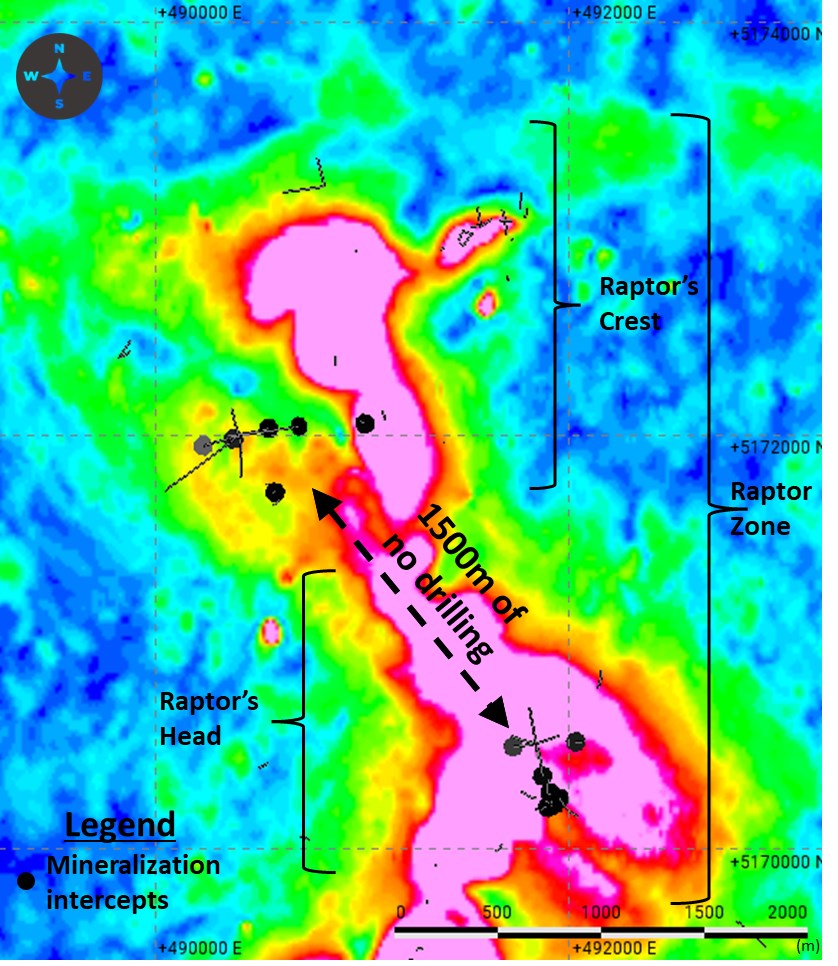
Assay results have been received for the six holes in the newly identified Raptor Zone, located nearly 2 miles (3.2 km) outside of the Tamarack Nickel Project’s resource area. These assays confirm that high-grade nickel mineralization exists well outside the Tamarack Nickel Project’s resource area in the largely unexplored Raptor Zone.
Talon believes it has confirmed a new “system” of high-grade nickel-copper mineralization within the Tamarack Intrusive Complex and is planning to drill an additional 20,000 meters within the Raptor Zone to determine if the 1-2 meters of identified high-grade massive nickel sulphide mineralization further thickens. During the winter drilling program, Talon had two drill rigs focused solely on exploration drilling, with a total of eight drill rigs operating.
Exploration drilling during the winter season has also focused on drilling various geophysical targets located within and outside of Tamarack Nickel Project’s resource area, and drilling of these targets remains ongoing. With the completion of the company’s winter drilling program, Talon has plans for additional exploration drilling, with three to four drill rigs turning for the remainder of 2023. Exploration will focus on further drilling within the new Raptor Zone, with an additional 20,000 meters of drilling planned. Additionally, the company plans to drill between 3,000-5,000 meters in an area located approximately 1 km south of the Tamarack Nickel Project’s resource area, where historic high-grade massive nickel sulphides have been identified but not yet followed up on.
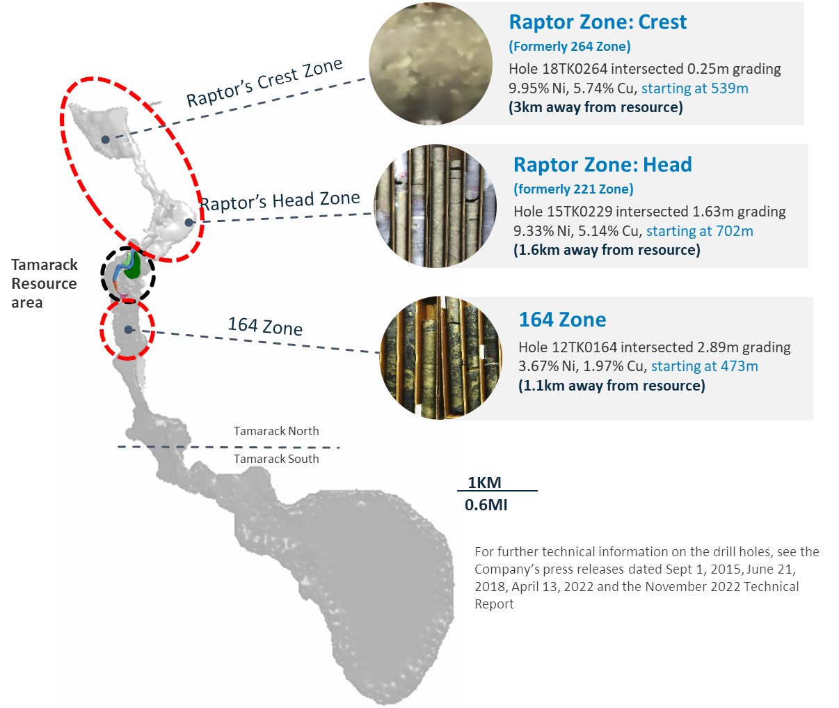
Table 1: Notable Assay Results from New Drill Holes in the Raptor Zone
| Drill Hole | From | To | Length | Assay | |||||
| # | (m) | (m) | (m) | Ni (%) | Cu (%) | Co (%) | Pd (g/t) | Pt (g/t) | Au (g/t) |
| Raptor Zone: Head Area | |||||||||
| 22TK0430 | 670.05 | 673.15 | 3.1 | 2.48 | 1.01 | 0.06 | 0.43 | 0.65 | 0.23 |
| including | 672.23 | 673.15 | 0.92 | 6.93 | 2.73 | 0.16 | 1.24 | 1.75 | 0.64 |
| 22TK0440 | 651.61 | 653.42 | 1.81 | 4.03 | 1.20 | 0.11 | 0.34 | 0.37 | 0.04 |
| including | 651.61 | 652.86 | 1.25 | 5.35 | 1.51 | 0.15 | 0.43 | 0.44 | 0.04 |
| Raptor Zone: Crest Area | |||||||||
| 22TK0439 | 539.86 | 542.49 | 2.63 | 2.20 | 1.14 | 0.06 | 0.29 | 0.38 | 0.34 |
| including | 541.94 | 542.49 | 0.55 | 4.96 | 2.76 | 0.13 | 0.83 | 0.89 | 1.13 |
The above references an opinion and is for information purposes only. It is not intended to be investment advice. Seek a licensed professional for investment advice. The author is not an insider or shareholder of any of the companies mentioned above.
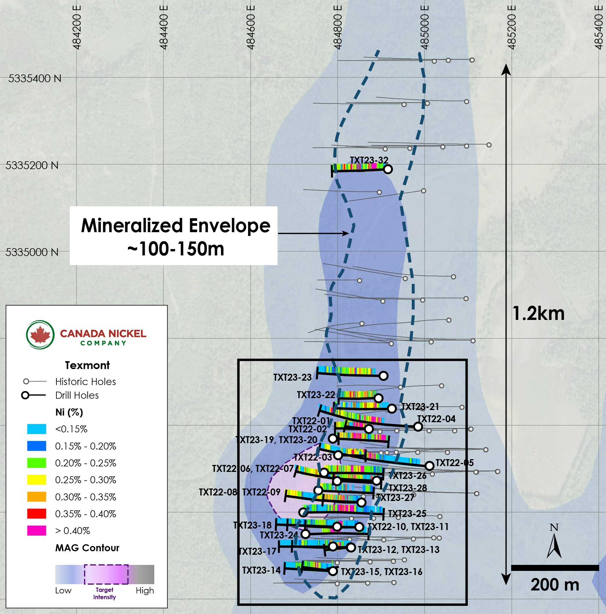
Canada Nickel Company (TSXV:CNC) has just announced a significant expansion of high-grade nickel mineralization at the Texmont property, located just over 35 kilometres south of Timmins, Ontario. The results, which were obtained through a recent assay, show that the mineralization is near the surface, making it easier to extract.
The company has drilled 39 holes, totaling almost 10,000 metres, as part of an exploration program designed to support the development of a resource. Assay results from 16 additional holes were released, with assays pending from another 11 holes.
All 39 drill holes have intersected mineralized peridotite, with the drill program confirming Canada Nickel’s interpretation of the Texmont deposit, displaying zoning in its mineralization. The high-grade core ranges from 2 to 8 metres thickness and has been identified as the main target of previous mining, while an outer shell of moderate-high mineralization ranges from 0.6-1.0% and can be up to 20 to 30 metres thick. Further outward shells of moderate and lower grades were also identified.
Overburden in the area varied between 2 and 18 metres in downhole length, with an average of 7.5 metres. The mineralization has been drilled over a footprint of 1 kilometre along strike to a maximum depth of 444 metres where it remains open.
The latest results confirm the Texmont deposit’s potential, and Canada Nickel will continue with its exploration program, which aims to identify additional high-grade nickel mineralization.
Mark Selby, CEO of Canada Nickel Company, commented in a press release: “The latest assay results continue to confirm our thesis of near-surface high grade intervals within thick mineralized sections which support the potential for near-term, smaller scale, open pit production. Of particular note, we are excited by the near-surface higher grade interval in hole TEX23-32 in the northern lens which is nearly half a kilometre from the southern high-grade lens. We have now planned additional drilling at the northern lens. We are looking forward to delivering an initial resource and Preliminary Economic Analysis (“PEA”) on Texmont this year as its near-term production potential is highly complementary to our large-scale Crawford and regional nickel sulphide project potential.”
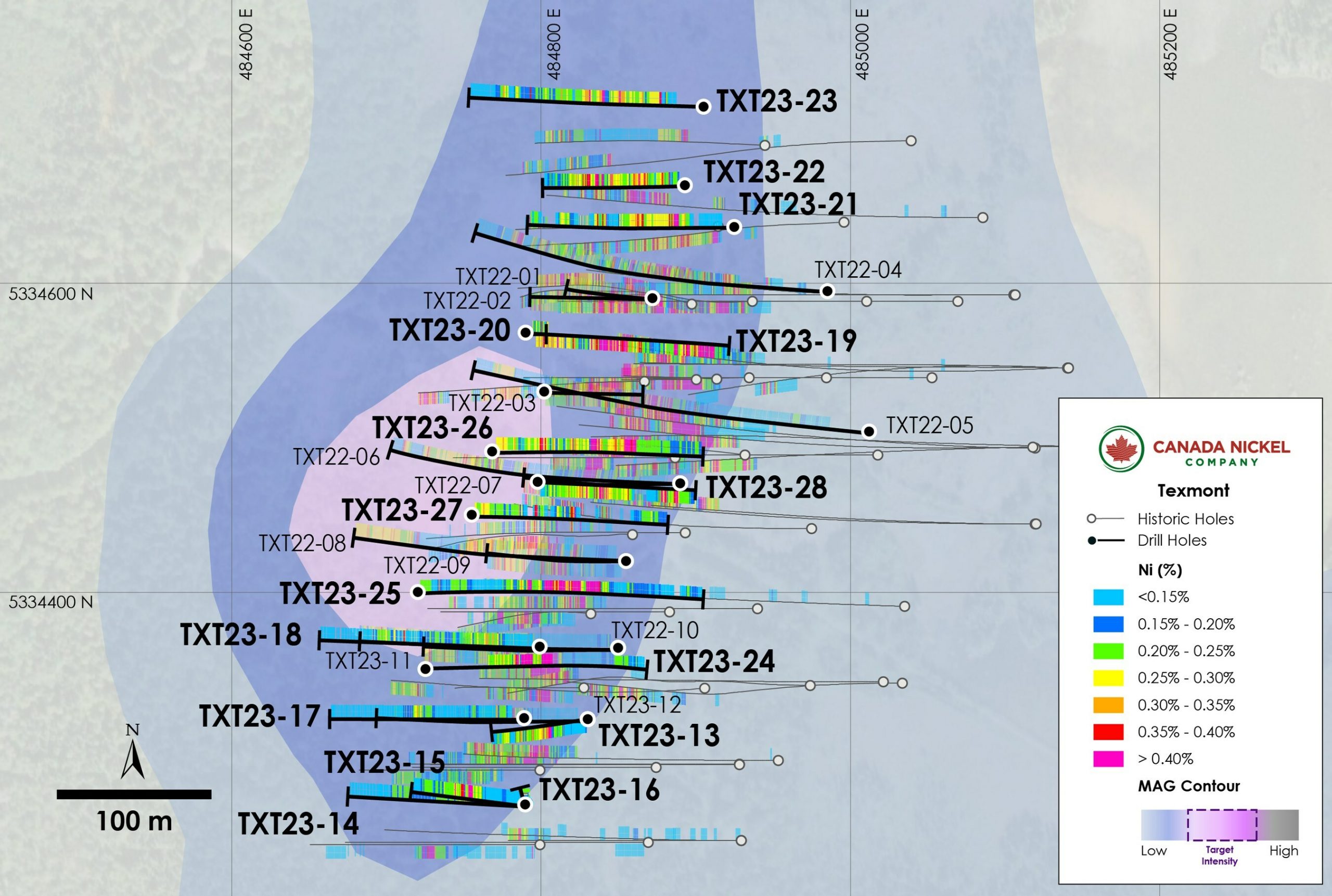
Highlights from the results are as follows:
- Assay results from 16 drillholes continue to confirm high-grade near-surface mineralization
- Nine drillholes with intersections of higher-grade (above 1% nickel) mineralization
- Hole TEX23-26 intersected 3 metres of 1.47% nickel within 13.5 metres of 0.82% nickel within 52.5 metres of 0.5% nickel
- Hole TEX23-19 intersected 7 metres of 1.03% nickel within 40.0 metres of 0.69% nickel
- High grade mineralization intersected in northern lens 470 metres from original high grade lens in the south area
- Hole TXT23-32 intersected 10.5 metres of 0.95% nickel within 43.5 metres of 0.59% nickel within 292 metres of 0.31% nickel
Table 1: Texmont exploration drilling results – high grade highlights
|
Hole ID |
From |
To |
Length* |
Ni |
Co |
Pd |
Pt |
Cr |
Fe |
S |
|
(m) |
(m) |
(m) |
( %) |
( %) |
(g/t) |
(g/t) |
( %) |
( %) |
( %) |
|
|
TXT22-13 |
153.0 |
174.0 |
21.0 |
0.52 |
0.02 |
0.036 |
0.030 |
0.15 |
5.68 |
0.63 |
|
and |
183.0 |
192.0 |
9.0 |
0.49 |
0.02 |
0.027 |
0.023 |
0.12 |
5.42 |
0.58 |
|
Including |
184 |
185.5 |
1.5 |
1.02 |
0.035 |
0.053 |
0.044 |
0.13 |
6.01 |
1.27 |
|
TXT23-15 |
85.5 |
104.5 |
19.0 |
0.57 |
0.02 |
0.034 |
0.024 |
0.16 |
6.00 |
0.66 |
|
including |
85.5 |
93.5 |
8.0 |
0.88 |
0.03 |
0.061 |
0.041 |
0.17 |
6.55 |
1.00 |
|
Including |
91.5 |
93.5 |
2 |
1.24 |
0.05 |
0.068 |
0.049 |
0.15 |
6.50 |
1.70 |
|
TXT23-16 |
202.5 |
223.5 |
21.0 |
0.48 |
0.02 |
0.035 |
0.023 |
0.13 |
5.57 |
0.59 |
|
Including |
217.5 |
223.5 |
6.0 |
0.72 |
0.02 |
0.060 |
0.040 |
0.14 |
5.65 |
1.09 |
|
Including |
219 |
221 |
2 |
1.03 |
1.03 |
0.03 |
0.094 |
0.060 |
0.13 |
5.82 |
|
TXT23-19 |
63 |
184 |
121 |
0.52 |
0.02 |
0.038 |
0.029 |
0.15 |
5.56 |
0.48 |
|
TXT23-19 |
63.0 |
98.7 |
35.7 |
0.70 |
0.02 |
0.060 |
0.045 |
0.14 |
5.27 |
0.70 |
|
and |
144.0 |
184.0 |
40.0 |
0.69 |
0.02 |
0.054 |
0.042 |
0.16 |
5.99 |
0.55 |
|
Including |
145.0 |
148.3 |
3.3 |
1.24 |
0.02 |
0.124 |
0.087 |
0.15 |
5.12 |
1.06 |
|
and |
156.5 |
160.0 |
3.5 |
1.20 |
0.03 |
0.100 |
0.071 |
0.15 |
5.75 |
0.94 |
|
including |
170.0 |
177.0 |
7.0 |
1.03 |
0.03 |
0.083 |
0.069 |
0.16 |
6.73 |
0.81 |
|
TXT23-21 |
64.5 |
70.5 |
6.0 |
0.90 |
0.02 |
0.082 |
0.072 |
0.15 |
5.65 |
0.42 |
|
including |
64.5 |
69.0 |
4.05 |
1.06 |
0.02 |
0.102 |
0.089 |
0.15 |
5.79 |
0.50 |
|
TXT23-22 |
153.0 |
193.5 |
40.5 |
0.34 |
0.01 |
0.017 |
0.015 |
0.17 |
5.83 |
0.50 |
|
TXT23-25 |
154.5 |
222.0 |
67.5 |
0.58 |
0.02 |
0.043 |
0.034 |
0.16 |
6.44 |
0.83 |
|
including |
156.0 |
164.0 |
8.0 |
0.85 |
0.03 |
0.074 |
0.054 |
0.15 |
7.43 |
1.27 |
|
including |
157.5 |
159.0 |
1.5 |
1.02 |
0.031 |
0.092 |
0.064 |
0.14 |
8.03 |
1.8 |
|
TXT23-26 |
112.5 |
165 |
52.5 |
0.50 |
0.01 |
0.047 |
0.044 |
0.14 |
5.48 |
0.53 |
|
Including |
151.5 |
165.0 |
13.5 |
0.82 |
0.02 |
0.125 |
0.079 |
0.15 |
5.53 |
0.94 |
|
Including |
151.5 |
156.0 |
4.5 |
1.13 |
0.02 |
0.159 |
0.102 |
0.15 |
6.04 |
1.29 |
|
TXT23-27 |
74.8 |
78.0 |
3.2 |
0.51 |
0.02 |
0.048 |
0.036 |
0.14 |
5.11 |
0.49 |
|
TXT23-28 |
103.5 |
130.5 |
27.0 |
0.52 |
0.02 |
0.033 |
0.042 |
0.14 |
5.47 |
0.62 |
|
Including |
123.0 |
124.5 |
1.5 |
1.29 |
0.038 |
0.147 |
0.046 |
0.13 |
7.02 |
2.01 |
|
Including |
129.0 |
130.5 |
1.5 |
1.43 |
0.045 |
0.156 |
0.519 |
0.14 |
6.37 |
1.91 |
|
and |
225.0 |
261.0 |
36.0 |
0.42 |
0.01 |
0.039 |
0.032 |
0.15 |
5.59 |
0.46 |
|
including |
258.0 |
261 |
3 |
1.15 |
0.04 |
0.235 |
0.177 |
0.13 |
5.63 |
1.62 |
|
TXT23-32 |
63.0 |
106.5 |
43.5 |
0.59 |
0.02 |
0.038 |
0.029 |
0.15 |
5.34 |
0.52 |
|
including |
63.0 |
73.5 |
10.5 |
0.95 |
0.02 |
0.071 |
0.047 |
0.14 |
5.08 |
0.79 |
|
including |
63 |
66 |
3 |
1.22 |
0.01 |
0.130 |
0.077 |
0.14 |
4.90 |
1.00 |
|
*Specified drillhole length, note that true widths are uncertain. Initial interpretation by the Company is that the nickel mineralization is hosted in steeply dipping zones, implying true widths in the range of 70% to 95% of reported intervals |
Table 2: Texmont exploration drilling results – downhole average
|
Hole ID |
From |
To |
Length* |
Ni |
Co |
Pd |
Pt |
Cr |
Fe |
S |
|
(m) |
(m) |
(m) |
( %) |
( %) |
(g/t) |
(g/t) |
( %) |
( %) |
( %) |
|
|
TXT22-13 |
5.0 |
387.0 |
382.0 |
0.21 |
0.01 |
0.008 |
0.009 |
0.17 |
6.33 |
0.33 |
|
including |
111.0 |
297.2 |
186.2 |
0.29 |
0.01 |
0.010 |
0.010 |
0.14 |
5.23 |
0.30 |
|
and |
317.8 |
387.0 |
69.2 |
0.21 |
0.01 |
0.008 |
0.009 |
0.27 |
6.17 |
0.28 |
|
TXT23-14 |
47.0 |
129.9 |
82.9 |
0.20 |
0.01 |
0.006 |
0.006 |
0.18 |
5.48 |
0.21 |
|
TXT23-15 |
47.5 |
169.8 |
122.3 |
0.27 |
0.01 |
0.010 |
0.011 |
0.19 |
6.08 |
0.35 |
|
TXT23-16 |
114.5 |
444 |
329.5 |
0.25 |
0.01 |
0.009 |
0.007 |
0.16 |
5.45 |
0.23 |
|
including |
192.0 |
285.0 |
93.0 |
0.30 |
0.01 |
0.016 |
0.011 |
0.15 |
5.37 |
0.28 |
|
TXT23-17 |
81.0 |
109.1 |
28.1 |
0.21 |
0.01 |
0.004 |
0.006 |
0.17 |
5.39 |
0.18 |
|
TXT23-18 |
40.5 |
109.7 |
69.2 |
0.21 |
0.01 |
0.008 |
0.007 |
0.15 |
4.90 |
0.15 |
|
and |
123.0 |
158.0 |
35.0 |
0.19 |
0.01 |
0.007 |
0.006 |
0.18 |
6.09 |
0.56 |
|
TXT23-19 |
10.0 |
193.7 |
183.7 |
0.43 |
0.01 |
0.027 |
0.022 |
0.14 |
5.45 |
0.44 |
|
TXT23-20 |
84.0 |
243.0 |
159.0 |
0.23 |
0.01 |
0.008 |
0.008 |
0.12 |
5.45 |
0.34 |
|
TXT23-21 |
51.3 |
135.7 |
84.4 |
0.28 |
0.01 |
0.014 |
0.014 |
0.14 |
5.39 |
0.19 |
|
and |
148.1 |
163.5 |
15.4 |
0.26 |
0.01 |
0.016 |
0.015 |
0.12 |
4.59 |
0.25 |
|
TXT23-22 |
12.0 |
260.8 |
248.8 |
0.26 |
0.01 |
0.011 |
0.009 |
0.16 |
5.44 |
0.24 |
|
TXT23-23 |
37.6 |
219.5 |
181.9 |
0.24 |
0.01 |
0.009 |
0.008 |
0.14 |
5.38 |
0.10 |
|
including |
82.5 |
120.0 |
37.5 |
0.30 |
0.01 |
0.012 |
0.009 |
0.15 |
5.03 |
0.12 |
|
TXT23-25 |
3.0 |
311.8 |
308.8 |
0.24 |
0.01 |
0.013 |
0.013 |
0.13 |
6.19 |
0.35 |
|
including |
125.0 |
240.0 |
115.0 |
0.44 |
0.01 |
0.029 |
0.024 |
0.15 |
5.84 |
0.58 |
|
TXT23-26 |
5.0 |
240.0 |
235.0 |
0.29 |
0.01 |
0.015 |
0.016 |
0.15 |
5.42 |
0.31 |
|
including |
52.5 |
165.0 |
102.5 |
0.37 |
0.01 |
0.026 |
0.026 |
0.15 |
5.54 |
0.42 |
|
TXT23-27 |
4.0 |
124.6 |
120.6 |
0.21 |
0.01 |
0.007 |
0.010 |
0.12 |
5.70 |
0.29 |
|
and |
191.2 |
231.0 |
39.8 |
0.20 |
0.01 |
0.007 |
0.014 |
0.19 |
5.88 |
0.14 |
|
TXT23-28 |
14.4 |
174.1 |
159.7 |
0.30 |
0.01 |
0.009 |
0.014 |
0.13 |
4.95 |
0.31 |
|
and |
222.6 |
291.0 |
68.4 |
0.33 |
0.01 |
0.022 |
0.021 |
0.15 |
5.52 |
0.32 |
|
TXT23-32 |
8.2 |
300.0 |
291.8 |
0.31 |
0.01 |
0.016 |
0.015 |
0.15 |
5.11 |
0.27 |
|
*Specified drillhole length, note that true widths are uncertain. Initial interpretation by the Company is that the nickel mineralization is hosted in steeply dipping zones, implying true widths in the range of 70% to 95% of reported intervals |
able 3: Texmont Drillhole Orientation
|
Hole ID |
Easting (mE) |
Northing (mN) |
Azimuth (⁰) |
Dip (⁰) |
Length (m) |
|
TXT23-13 |
484830 |
5334318 |
270 |
-82 |
387 |
|
TXT23-14 |
484790 |
5334263 |
270 |
-45 |
162 |
|
TXT23-15 |
484790 |
5334263 |
270 |
-65 |
180 |
|
TXT23-16 |
484790 |
5334263 |
270 |
-90 |
444 |
|
TXT23-17 |
484789 |
5334319 |
270 |
-45 |
171 |
|
TXT23-18 |
484799 |
5334365 |
270 |
-45 |
201 |
|
TXT23-19 |
484790 |
5334568 |
90 |
-48 |
201 |
|
TXT23-20 |
484790 |
5334568 |
90 |
-86 |
243 |
|
TXT23-21 |
484925 |
5334636 |
270 |
-57 |
234 |
|
TXT23-22 |
484893 |
5334663 |
270 |
-70 |
264 |
|
TXT23-23 |
484905 |
5334714 |
270 |
-52 |
246 |
|
TXT23-25 |
484720 |
5334400 |
90 |
-58 |
351 |
|
TXT23-26 |
484768 |
5334491 |
90 |
-55 |
240 |
|
TXT23-27 |
484755 |
5334450 |
90 |
-55 |
231 |
|
TXT23-28 |
484798 |
5334471 |
90 |
-70 |
291 |
|
TXT23-32 |
484915 |
5335188 |
265 |
-65 |
300 |
TXT23-13 was collared in komatiite, and intersected a thick sequence of mineralized peridotite, with minor dykes encountered near surface. The hole averaged 0.21% nickel over 382.0 metres, including a higher-grade section of 0.52% nickel over 21.0 metres (see Table 1 for higher grade composites, and Table 2 for entire mineralized composites).
TXT23-14 was collared 70 metres southwest of TXT23-13 and intersected weakly mineralized komatiite 4.7 metres below surface, intersecting mineralized peridotite for a length of 82.9 metres until encountering volcanics at the lower contact. The peridotite section averaged 0.20% nickel.
TXTX23-15 was collared in the same setup as TXT23-14 drilling steeper, intersected komatiite followed by well mineralized peridotite for 122.3 metres. The hole averaged 0.27% nickel, including 0.88% nickel and 0.10g/t Pt+Pd over 8.0 metres.
TXT23-16 was collared on komatiite at 3 metres followed by well mineralized peridotite to end of hole. The mineralized peridotite averaged 0.25% nickel over 329.5 metres, including 0.48% nickel over 21.0 metres.
TXT23-17 was collared in hanging wall mafic intrusive and followed a succession of komatiite and mafic volcanics before intersecting mineralized peridotite at 81 metres. The hole intersected 28.1 metres of peridotite averaging 0.21% nickel.
TXT23-18 was drilled 55 metres northwest of TXT23-13 in komatiite and intersected mineralized peridotite, interrupted by a section of metasediments. The top peridotite averaged 0.21% nickel over 69.2 metres, while the bottom peridotite averaged 0.19% nickel over 35.0 metres.
TEX23-19 was collared 55 metres northwest of the shaft, intersecting well mineralized peridotite at 10 metres below surface, interrupted by minor diabase dykes. The hole averaged 0.43% nickel over 183.7 metres including 0.69% nickel over 40.0 metres and 1.03% nickel over 7.0 metres.
TXT23-20 was collared and ended in mineralized peridotite. The bottom of the hole averaged 0.23% nickel over 159.0 metres including 0.31% nickel over 100.2 metres. Top of hole assays are still pending.
TXT23-21 was collared in komatiite with minor dykes, followed by mineralized peridotite. The top peridotite averaged 0.28% nickel over 84.4 metres, including 0.90% nickel over 6.0 metres and 0.35% nickel over 49.3 metres. The bottom peridotite averaged 0.26% nickel over 15.4 metres.
TXT23-22 was collared in mineralized peridotite at 12 metres below surface. The hole averaged 0.26% nickel over 248.8 metres including 0.34% nickel over 40.5 metres.
TXT23-23 was collared approximately 220 metres northeast of the shaft. The hole intersected 0.24% nickel over 181.9 metres, including 0.30% nickel over 37.5 metres.
TXT23-24 was collared at the hanging wall mafic volcanics and intersected well mineralized peridotite starting at 13.8 metres. The hole has 0.71% nickel over 21.0 metres. Top and bottom of hole assays are still pending.
TXT23-25 was collared on komatiite at 3 metres followed by diabase and a well mineralized peridotite to end of hole. The hole averaged 0.24% nickel over 308.8 metres, including a section of well mineralized peridotite averaging 0.58% nickel over 64.8 metres, including 0.85% nickel over 8.0 metres.
TXT23-26 was collared in mineralized peridotite at 5.0 metres below surface. The hole averaged 0.29% nickel over 235.0 metres including 0.50% nickel over 52.5 metres.
TXT23-27 collared on peridotite at 4 metres below surface and ended in peridotite except for a gabbro section near the bottom of the hole. The top peridotite averaged 0.21% nickel over 120.6 metres, while the bottom peridotite averaged 0.20% nickel over 39.8 metres.
TXT23-28 collared in mafic volcanics at 5.5 metres, followed by well mineralized peridotite starting at 14.4 metres. This section of the peridotite averaged 0.30% nickel over 159.7 metres and included a section of 0.52% nickel over 27.0 metres. The hole is interrupted by a section of a later intrusion but continues on well mineralized peridotite averaging 0.33% nickel over 68.4 metres and includes 0.42% nickel over 36.0 metres.
TXT23-32 is collared in the north zone approximately 650 metres from the shaft. The hole starts on komatiite and remains in mineralized peridotite to the end of the hole. The hole averaged 0.31% nickel over 291.8 metres and includes 0.59% nickel over 43.5 metres with 10.5 metres of 0.95% nickel.
The above references an opinion and is for information purposes only. It is not intended to be investment advice. Seek a licensed professional for investment advice. The author is not an insider or shareholder of any of the companies mentioned above.
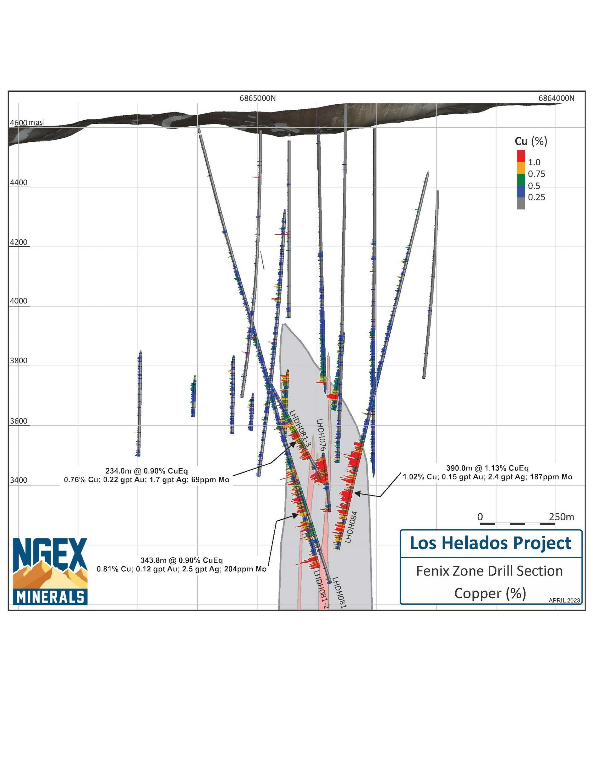
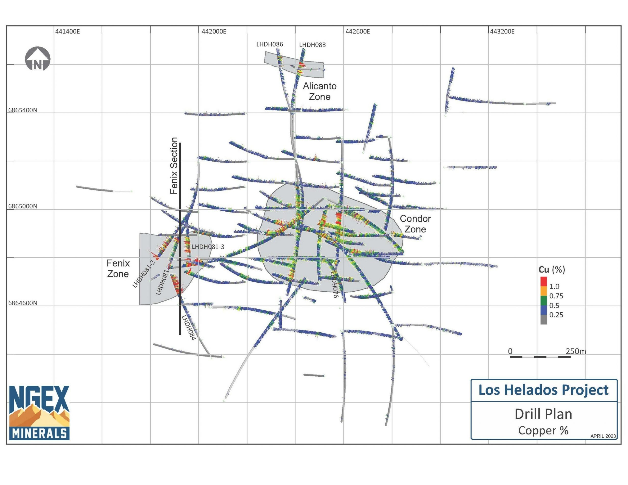
NGEx Minerals Ltd. (TSXV: NGEX) has released new assay findings from four drilled holes at the Los Helados copper-gold project situated in Region III, Chile. These results showcase some of the most exceptional grades ever encountered at Los Helados, especially with regards to molybdenum grades which surpass all previous intersections. They also provide evidence that the Fenix Zone is rapidly evolving into a second significant center of mineralization. The majority of the new drilling carried out in the Fenix and Alicanto Zones lies beyond the current Los Helados Mineral Resource, and both zones have potential for expansion in multiple directions.
Wojtek Wodzicki, President and CEO, commented in a press release: “The 2023 exploration program is shaping up to be the most successful and impactful in the Company’s history. Years of hard work and exploration experience are coming together to deliver a series of high impact discoveries. Last week we released high-grade results from the new Potro Cliffs discovery which is the fourth major system discovered in the Vicuña District. Today’s results from Los Helados, 9 kilometres to the north of Potro Cliffs, continue to confirm the Fenix and Alicanto Zones as significant new centres of high-grade mineralization. Both of these zones have considerable room to grow, and offer the potential for a meaningful expansion of the Los Helados resource. We are particularly encouraged by the copper and molybdenum grades of these new zones, which are significantly higher than the averages seen to date. This season’s drilling is proving the exploration adage that ‘Big systems tend to grow and deliver continued positive surprises.”
Highlights from the results are as follows:
- LHDH081-2: Fenix Zone:
- 343.8m at 0.90% CuEq, including 63.8m at 1.25% CuEq
- LHDH081-3: Fenix Zone:
- 234.0m at 0.90% CuEq, including 28.0m at 1.49% CuEq
- LHDH084: Fenix Zone:
- 390.0m at 1.13% CuEq
- LHDH086: Alicanto Zone:
- 104.0m at 0.69% CuEq
Composited intervals are shown in the table below. Note molybdenum (Mo) grades are not included in the CuEq calculation:
|
Hole ID |
From |
To |
Length (m) |
Cu % |
Au g/t |
Ag g/t |
CuEq % |
Mo ppm |
Zone* |
|
LHDH081-2 |
770.7 |
1549.8 |
779.1 |
0.54 |
0.10 |
2.0 |
0.61 |
121 |
Fenix |
|
incl |
1206.0 |
1549.8 |
343.8 |
0.81 |
0.12 |
2.5 |
0.90 |
204 |
|
|
incl |
1486.0 |
1549.8 |
63.8 |
1.14 |
0.14 |
3.6 |
1.25 |
741 |
|
|
LHDH81-3 |
814.0 |
1266.0 |
452.0 |
0.54 |
0.15 |
1.3 |
0.64 |
57 |
Fenix |
|
incl |
1032.0 |
1266.0 |
234.0 |
0.76 |
0.22 |
1.7 |
0.90 |
69 |
|
|
incl |
1032.0 |
1186.0 |
154.0 |
0.85 |
0.25 |
1.8 |
1.02 |
80 |
|
|
incl |
1238.0 |
1266.0 |
28.0 |
1.25 |
0.36 |
2.6 |
1.49 |
91 |
|
|
LHDH084 |
728.0 |
1500.0 |
772.0 |
0.67 |
0.11 |
1.7 |
0.74 |
119 |
Fenix |
|
incl |
1110.0 |
1500.0 |
390.0 |
1.02 |
0.15 |
2.4 |
1.13 |
187 |
|
|
LHDH086 |
938.0 |
1042.0 |
104.0 |
0.60 |
0.14 |
2.2 |
0.69 |
48 |
Alicanto |
|
incl |
998.0 |
1042.0 |
44.0 |
0.75 |
0.22 |
2.7 |
0.90 |
50 |
|
Mineralized zones within the Los Helados deposit are bulk porphyry-style zones and drilled widths are interpreted to be essentially true widths. |
|
Copper Equivalent (CuEq) for drill intersections is calculated based on US$ 3.50/lb Cu, US$ 1,700/oz Au and US$ 20/oz Ag, with metallurgical recoveries of 88% for copper, 76% for gold and 60% for silver based on a comprehensive program of metallurgical testwork. The formula is: CuEq % = Cu % + (0.6117 * Au g/t) + (0.0057 * Ag g/t). |
LHDH081-2 was a daughter hole kicked off LHDH081 at a depth of 780.0m and angled towards the southwest. It was drilled to a final depth of 1,549.8m, intersecting the Fenix Zone between 35m and 90m to the west of LHDH081. The zone remains open to the west of this hole.
The Fenix Zone was intersected over a 343.8m interval from 1,206.0m to 1,549.8m and consists of a clast-supported hydrothermal breccia with a matrix composed of anhydrite, chalcopyrite, quartz and biotite. The average grade of this interval is 0.81% Cu, 0.12 g/t Au and 204ppm Mo which is considerably higher than the Los Helados deposit average.
The hole ended due to rig capacity in high-grade mineralization, with the final 20m averaging 1.36% CuEq (1.27% Cu, 0.11 g/t Au, 3.1 g/t Ag) plus 1540ppm Mo. Note that Mo is not currently included in the CuEq calculation.
LHDH081-3 was kicked off hole LHDH081-2 at a depth of 786.6m and angled towards the south to investigate the gap between holes LHDH081 and LHDH076. The hole encountered the Fenix Zone at a depth of 1,032.0m and drilled it to a final depth of 1,266.0m resulting in a partial intersection of 234.0m at an average grade of 0.76% Cu and 0.22 g/t Au. The hole was terminated due to technical complications on the part of the drill contractor.
The Fenix Zone in this hole was split by a low-grade porphyry dyke from 1,186.0m to 1,238.0m (52m) resulting in dilution to the overall intersection. This dyke was also intersected in holes LHDH076 and LHDH081 and its true width is estimated at 20-25m, indicating that it has a disproportionate impact on the overall grade of the intervals due to the angle of intersection with the drill hole.
LHDH084 was drilled from south to north across the Fenix Zone in the opposite direction from the LHDH081 series holes. The hole terminated in high-grade mineralization due to rig capacity at 1,500.0m, resulting in a partial Fenix Zone intersection of 390.0m grading 1.02% Cu, 0.15 g/t Au and 187ppm Mo.
The southern contact of the Fenix Zone was intersected at a depth of 1,110.0m which puts it 250m due south of the northern contact as intersected in hole LHDH081, establishing a minimum horizontal width for the zone. This hole ended 100m to the southeast of the end of LHDH081-2.
LHDH086 intersected the Alicanto Zone from 938.0m to 1,042.0m and returned 0.60% Cu and 0.14 g/t Au, including a higher-grade interval of 44.0m with 0.75% Cu and 0.22 g/t Au. This intersection is 60m to the west of the discovery hole, LHDH078, and the zone remains open in several directions beyond it.
2022/23 LOS HELADOS DRILL PROGRAM OVERVIEW
Los Helados contains at least three distinct high-grade zones hosted within well-defined structural corridors that cross cut the large breccia body that hosts the deposit; the Alicanto Zone, the Condor Zone, and the Fenix Zone.
The current drilling program is focused on defining the geometry and size of the Alicanto and Fenix Zones. Holes currently completed with assays pending, or in progress are outlined below:
Holes Completed and in Progress
LHDH085: Drilling from north to south to intersect the Fenix Zone 140m east of LHDH076. Complete, assays pending.
LHDH086-1: Target 100m step-out to the east of LHDH078 on the Alicanto Zone. Complete, assays pending.
LHDH086-2: Target 100m step-out to the south of LHDH078 on the Alicanto Zone. Complete, assays pending.
LHDH087: Target to west of LHDH081-2 and LHDH084 on the Fenix Zone. In progress.
LHDH088: Drilling from north to south, across the Fenix Zone between LHDH076 and LHDH084. In progress.
NEXT STEPS
The final two holes of the program are underway, supported by a directional drilling crew from STYR SpA, a leading provider of Devico directional drilling technology. The Company has also completed a comprehensive geophysical program to assist in targeting higher grade mineralization including a 3D IP/Resistivity survey, a drone magnetics survey, and a magneto-telluric survey. Results are currently being processed and will help guide a comprehensive interpretation combined with the results of the current drilling program.
The above references an opinion and is for information purposes only. It is not intended to be investment advice. Seek a licensed professional for investment advice. The author is not an insider or shareholder of any of the companies mentioned above.
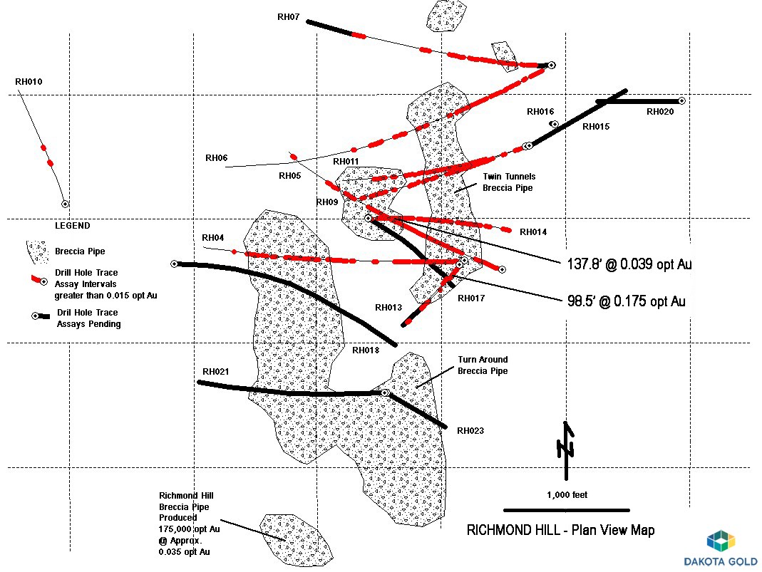
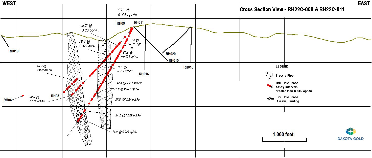
Dakota Gold (NYSEAmerican:DC) has just released exciting news about its Richmond Hill Gold Project. The company has announced the results from five additional drill holes, which have delineated an extensive gold system more than a mile in length from north to south, with the gold mineralization open in all directions.
The latest drilling at Richmond Hill aimed to locate higher-grade gold mineralization, particularly at the intersection of a dominant north-south structure with northeast-southwest crossing structures within the Twin Tunnels Breccia Pipe. The results of drill hole RH22C-013 are impressive, with an intersection of 0.175 oz/ton Au over 98.5 feet (5.98 grams/tonne over 30.0 meters). This confirms the existence of higher-grade gold mineralization, which may be related to preferential structures.
The Richmond Hill Gold Project consists of six known breccia pipes, four of which remain largely untested. To date, Dakota Gold has only drill-tested the Twin Tunnels and Twin Tunnels West Breccia Pipes. However, both of these are open to extension at depth and laterally to the north and south. It is important to note that between 1988 and 1994, LAC Minerals produced an impressive 175,000 ounces of gold from the Richmond Hill Breccia Pipe, which is similarly open to extension.
James M. Berry, Vice President of Exploration of Dakota Gold, commented in a press release: “Richmond Hill continues to provide positive drill results with RH22C-013 confirming the presence of higher-grade gold mineralization in the Twin Tunnels Breccia Pipe. We are seeing large intervals of visible alteration in the drilling and are using historical drilling, geophysics, and surface mapping to test the known breccia pipes for better grade mineralization. Four previously known breccia pipes remain untested.”
Highlights from the results are as follows:
- RH22C-013 intersected 0.175 oz/ton Au over 98.5 feet (5.98 grams/tonne over 30.0 meters) in a Tertiary breccia and confirmed the presence of higher-grade gold mineralization at Richmond Hill in the Twin Tunnels Breccia Pipe and confirms higher-grade gold mineralization found in historical drill hole TT-86-26.
- RH23C-014 intersected 0.039 oz/ton Au over 137.8 feet (1.35 grams/tonne over 42.0 meters) in the Twin Tunnels West Breccia Pipe. RH23C-014 was designed to test the Twin Tunnels West Breccia Pipe closer to the surface.
- RH22C-009 intersected 0.035 oz/ton Au over 16.8 feet (1.21 grams/tonne over 5.1 meters) in the Twin Tunnels Breccia Pipe. RH22C-010 intersected 0.024 oz/ton Au over 50.6 feet (1.24 grams/tonne over 1.54 meters) 2,500 feet west of the Twin Tunnels West Breccia Pipe. RH22C-011 intersected 0.036 oz/ton Au over 50.6 feet (1.24 grams/tonne over 15.4 meters) in the Twin Tunnels Breccia Pipe.
- Dakota Gold has identified a large gold system at Richmond Hill with drilling underway to test the remaining breccia pipes. Tertiary breccia pipes are favorable conduits for gold bearing fluids in the Homestake District and continue to be a priority drill target. Drilling and geologic reinterpretation has demonstrated two large breccia pipes are one larger system.
The Company currently has four drills operating on its properties in the Homestake District of South Dakota, with two drills operating at the Maitland Gold Project (“Maitland”) targeting Homestake-hosted and Tertiary gold mineralization.
Two drills operating at Richmond Hill are targeting Tertiary breccia and replacement gold mineralization, as well as conducting infill and step-out drilling designed to convert and expand the known gold mineralization identified in 880 historic drill holes, to S-K 1300 compliant resources.
Richmond Hill is located 2.3 miles west of Maitland and 1.5 miles north of Coeur Mining, Inc.’s Wharf Mine. The Wharf Mine produced 79,768 ounces at 0.021 oz/ton gold in 2022.
Exploration Update:
RH22C-009
RH22C-009 was drilled to test between RH22C-005 and RH22C-006 (see December 8, 2022 press release) at the Twin Tunnels Breccia Pipe as shown in Figure 1 and Figure 2. The drill hole intersected multiple zones of mineralization as shown in Table 1, with the best interval intersecting 0.022 oz/ton Au over 76.9 feet (0.77 grams/tonne over 23.4 meters). The mineralization was hosted within a Tertiary breccia composed of altered or bleached Precambrian, greenstone clasts.
RH22C-010
RH22C-010 was drilled to test an area 2,500 feet west of the Twin Tunnels West Breccia Pipe as shown in Figure 1 for historically identified Tertiary replacement gold mineralization hosted in the Cambrian Deadwood Formation and the Precambrian stratigraphy. This drill hole intersected 0.024 oz/ton Au over 18.7 feet (0.82 grams/tonne over 5.7 meters) in a fractured Tertiary lamprophyre sill. RH22C-010 also intersected 0.016 oz/ton Au over 13.1 feet (0.55 grams/tonne over 4.0 meters) in the lower Deadwood Formation. The lower portion of the drill hole contained Precambrian greenstone.
RH22C-011
RH22C-011 was drilled to test below RH22C-009, intersecting 0.036 oz/ton Au over 50.6 feet (1.24 grams/tonne over 15.4 meters) in Tertiary breccia and is shown in Figure 2. RH22C-011 also intersected 0.021 oz/ton Au over 54.9 feet (0.74 grams/tonne over 16.7 meters) in the lower Deadwood Formation and Tertiary altered Precambrian phyllites below the unconformity. The drill hole also intersected 0.017 oz/ton Au over 75.1 feet (0.57 grams/tonne over 22.9 meters) and 0.024 oz/ton Au over 52.8 feet (0.84 grams/tonne over 16.1 meters) in Tertiary breccias with Precambrian greenstone clasts.
RH22C-013
RH22C-013 was drilled to test for higher-grade gold mineralization at the Twin Tunnels Breccia Pipe. The drill hole was drilled from the same pad as RH22C-012 (see December 8, 2022 press release) at a shallower angle. RH22C-013 intersected 0.175 oz/ton Au over 98.5 feet (5.98 grams/tonne over 30.0 meters) in oxidized Tertiary breccia and fractured Precambrian phyllites as shown in Figure 3 and 4. The drill hole also intersected 0.039 oz/ton Au over 33.4 feet (1.33 grams/tonne over 10.2 meters) in Tertiary breccia. RH22C-013 demonstrates the potential for higher gold grades within the breccia pipes at Richmond Hill.
RH23C-014
RH23C-014 was drilled to test the upper portion of the Twin Tunnels Breccia Pipe above RH22C-005 as shown in Figures 1 and 5. RH22C-014 intersected 0.028 oz/ton Au over 88.9 feet (0.95 grams/tonne over 27.1 meters), 0.039 oz/ton Au over 137.8 feet (1.35 grams/tonne over 42.0 meters), and 0.023 oz/ton Au over 84.9 feet (0.77 grams/tonne over 25.9 meters), extending the Tertiary breccia hosted mineralization intersected in RH22C-005 closer to the surface.
Table 1. RH22C-009, RH22C-010, RH22C-011, RH22C-013 and RH23C-014 Drill Results (Imperial / Metric Units)
| Hole # | From | To | Depth | Interval* | Gold | From | To | Depth | Interval* | Gold | Mineral Type |
| ft | ft | ft | ft | oz/ton | m | m | m | m | |||
| RH22C-009 | 81.2 | 98.0 | 47.0 | 16.8 | 0.035 | 24.7 | 29.8 | 14.0 | 5.1 | 1.21 | Ꞓ |
| 485.5 | 505.0 | 232.0 | 19.5 | 0.026 | 148.0 | 153.9 | 71.0 | 5.9 | 0.91 | Bx | |
| 542.7 | 597.9 | 258.0 | 55.2 | 0.020 | 165.4 | 182.2 | 79.0 | 16.8 | 0.68 | Bx | |
| 955.4 | 1032.3 | 408.0 | 76.9 | 0.022 | 291.2 | 314.6 | 124.0 | 23.4 | 0.77 | Bx | |
| 1894.5 | 1934.5 | 1238.0 | 40.0 | 0.019 | 577.4 | 589.6 | 377.0 | 12.2 | 0.64 | Bx | |
| 2042.8 | 2081.4 | 1392.0 | 38.6 | 0.022 | 622.6 | 634.4 | 424.0 | 11.8 | 0.77 | Bx | |
| RH22C-010 | 527.3 | 546.0 | 315.0 | 18.7 | 0.024 | 160.7 | 166.4 | 96.0 | 5.7 | 0.82 | Tert |
| RH22C-011 | 61.6 | 116.5 | 44.0 | 54.9 | 0.021 | 18.8 | 35.5 | 13.0 | 16.7 | 0.74 | Ꞓ |
| 616.2 | 639.5 | 424.0 | 23.3 | 0.020 | 187.8 | 194.9 | 129.0 | 7.1 | 0.69 | Bx | |
| 786.4 | 837.0 | 530.0 | 50.6 | 0.036 | 239.7 | 255.1 | 162.0 | 15.4 | 1.24 | Bx | |
| 1108.2 | 1183.3 | 715.0 | 75.1 | 0.017 | 337.8 | 360.7 | 218.0 | 22.9 | 0.57 | Bx | |
| 1277.0 | 1329.8 | 813.0 | 52.8 | 0.024 | 389.2 | 405.3 | 248.0 | 16.1 | 0.84 | Bx | |
| 1388.1 | 1405.0 | 903.0 | 21.9 | 0.019 | 423.1 | 428.2 | 275.0 | 5.1 | 0.65 | Bx | |
| 1457.6 | 1478.5 | 950.0 | 20.9 | 0.017 | 444.3 | 450.7 | 290.0 | 6.4 | 0.58 | Bx | |
| 1645.4 | 1676.9 | 1135.0 | 31.5 | 0.017 | 501.5 | 511.1 | 346.0 | 9.6 | 0.57 | Bx | |
| 1790.1 | 1817.6 | 1292.0 | 27.5 | 0.024 | 545.6 | 554.0 | 394.0 | 8.4 | 0.83 | Bx | |
| 2188.4 | 2212.6 | 1675.0 | 24.2 | 0.028 | 667.0 | 674.4 | 511.0 | 7.4 | 0.95 | Bx | |
| 2332.6 | 2377.5 | 1828.0 | 44.9 | 0.028 | 711.0 | 724.7 | 557.0 | 13.7 | 0.98 | Bx | |
| RH22C-013 | 27.5 | 126.0 | 21.0 | 98.5 | 0.175 | 8.4 | 38.4 | 6.0 | 30.0 | 5.98 | Bx |
| including | 31.6 | 111.7 | 25.0 | 80.1 | 0.209 | 9.6 | 34.0 | 7.0 | 24.4 | 7.15 | Bx |
| 237.9 | 271.3 | 173.0 | 33.4 | 0.039 | 72.5 | 82.7 | 53.0 | 10.2 | 1.33 | Bx | |
| RH23C-014 | 133.6 | 150.6 | 109.0 | 17.0 | 0.029 | 40.7 | 45.9 | 33.0 | 5.2 | 0.99 | Bx |
| 175.8 | 264.7 | 139.0 | 88.9 | 0.028 | 53.6 | 80.7 | 42.0 | 27.1 | 0.95 | Bx | |
| 279.9 | 417.7 | 217.0 | 137.8 | 0.039 | 85.3 | 127.3 | 66.0 | 42.0 | 1.35 | Bx | |
| 480.4 | 565.3 | 372.0 | 84.9 | 0.023 | 146.4 | 172.3 | 113.0 | 25.9 | 0.77 | Bx | |
| 585.0 | 636.2 | 443.0 | 51.2 | 0.033 | 178.3 | 193.9 | 135.0 | 15.6 | 1.13 | Bx | |
| 649.8 | 729.8 | 488.0 | 80.0 | 0.020 | 198.1 | 222.5 | 149.0 | 24.4 | 0.70 | Bx | |
| 1039.0 | 1087.8 | 718.0 | 48.8 | 0.022 | 316.7 | 331.6 | 219.0 | 14.9 | 0.77 | Bx | |
| 1154.8 | 1202.3 | 822.0 | 47.5 | 0.023 | 352.0 | 366.5 | 351.0 | 14.5 | 0.79 | Bx | |
| 1473.2 | 1538.4 | 1084.0 | 65.2 | 0.021 | 449.0 | 468.9 | 330.0 | 19.9 | 0.71 | Bx | |
| 1657.7 | 1747.0 | 1222.0 | 89.3 | 0.022 | 505.3 | 532.5 | 372.0 | 27.2 | 0.77 | Bx |
*True thickness is unknown.
Abbreviations in the table include ounces per ton (“oz/ton”); grams per tonne (“g/t”); feet (“ft”); meter (“m”); Tertiary (“Tert”); Cambrian (“Ꞓ”); Breccia (Bx) and Precambrian (“pꞒ”).
The above references an opinion and is for information purposes only. It is not intended to be investment advice. Seek a licensed professional for investment advice. The author is not an insider or shareholder of any of the companies mentioned above.
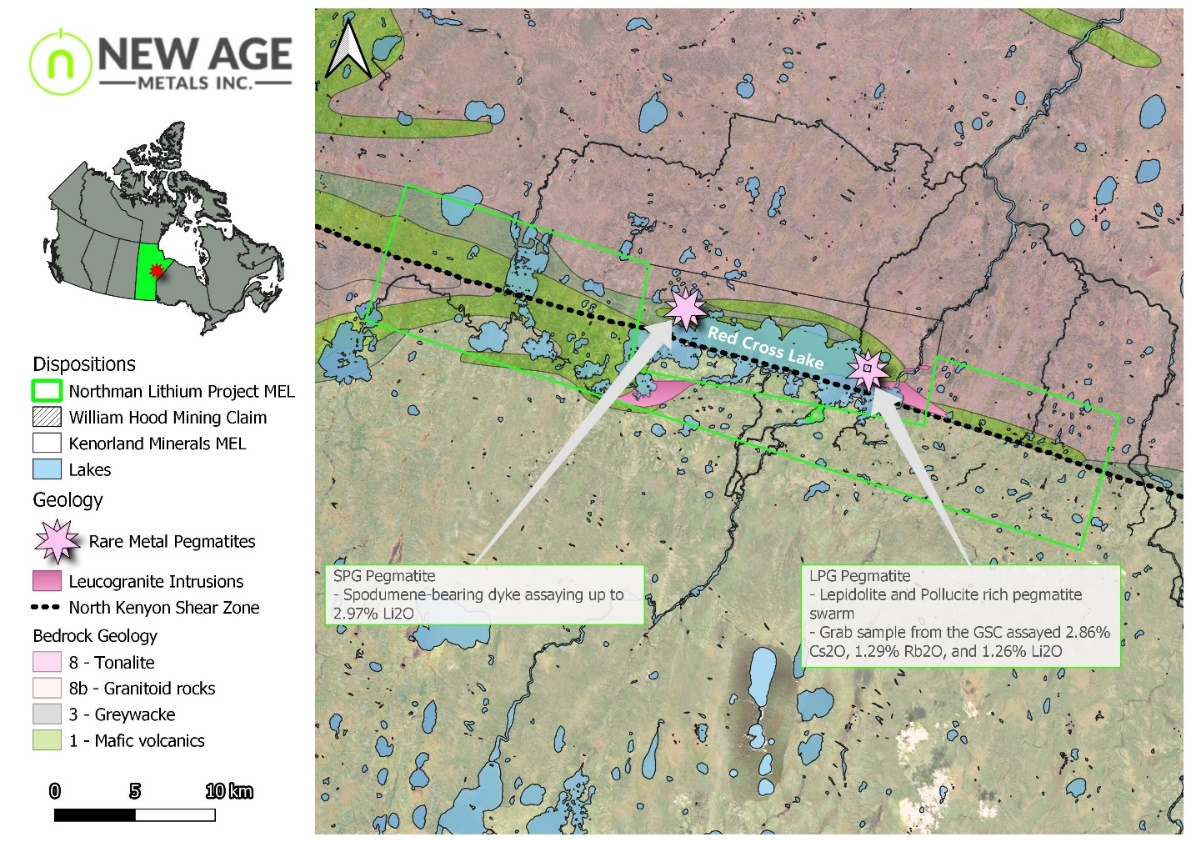
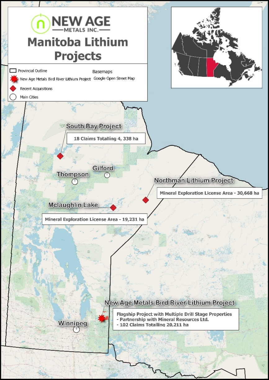
New Age Metals Inc. (TSXV:NAM) has reported news from its operations and exploration projects. The company has successfully acquired a mineral exploration license (MEL) area covering an impressive 30,668 hectares surrounding Red Cross Lake, Manitoba. This marks NAM’s third property acquisition of 2023, with the newly acquired Northman Lithium Project being a significant addition to its portfolio. The MEL covers an extensive 28 km stretch of the North Kenyon Shear Zone, which encircles an LCT pegmatite swarm found at Red Cross Lake.
Historical assays of the pegmatite have revealed up to 1.25% Li2O and 2.86% Cs2O (LPG pegmatite) and 2.97% Li2O (SPG pegmatite). The Northman Lithium Project is situated within the underexplored Oxford-Stull domain in Northern Manitoba’s Red Cross Lake greenstone belt, known for its highly fractionated lithium-bearing pegmatites. All claims related to this project are held by Lithium Canada Development, a 100% owned Lithium Division of New Age Metals.
Harry Barr, Chairman and CEO of New Age Metals Inc. commented in a press release: “It is fantastic to see our research efforts and diligence paying off with the addition of this highly prospective ground. While we work and develop our Southeast Manitoba projects through the joint venture with Mineral Resources Ltd., we intend to be a leader and prospect generator for green metals in Canada. Our three recent 100% owned project acquisitions now give us a large lithium focused portfolio with excellent exploration targets in Northern Manitoba. Together with our technical team from Axiom Exploration Group Ltd., we are currently working on a comprehensive go-forward exploration plan for these properties as we patiently await the snow to melt so our crew can get boots on the ground.”
Highlights from the Northman Lithium Project are as follows:
- Along trend of lithium bearing pegmatites documented at Red Cross Lake
- LPG Pegmatite:
- Lepidolite and Pollucite rich pegmatite swarm with 17 parallel and sheared dykes up to 4 meters in width over an area of ~50 meters
- Work by the Geological Survey of Canada in the 1960’s identified the rubidium and cesium potential of these pegmatites, with one sample assaying 2.86% CsO, 1.29% RbO, and 1.26% Li 1
- SPG Pegmatite:
- Spodumene-bearing dyke with grab samples assaying up to 2.97% LiO
- LPG Pegmatite:
- In terms of K/Rb ratios, the pegmatites in the Red Cross area are ranked with the most evolved spodumene pegmatites worldwide
- Large leucogranite intrusions within the MEL zone that occur up to 5 km long and attain a maximum width of 90 meters. Thin-section analysis of these units identified the presence of spodumene and quartz replacing petalite
- Property covers 30 km of strike extent of the North Kenyon Shear Zone, a regional-scale structure in which “the pegmatitic rocks are situated within, or closely adjacent to” 4,5
- Identified targets from regional magnetics that are analogous to those hosting rare-metal pegmatites at Red Cross Lake.
The above references an opinion and is for information purposes only. It is not intended to be investment advice. Seek a licensed professional for investment advice. The author is not an insider or shareholder of any of the companies mentioned above.
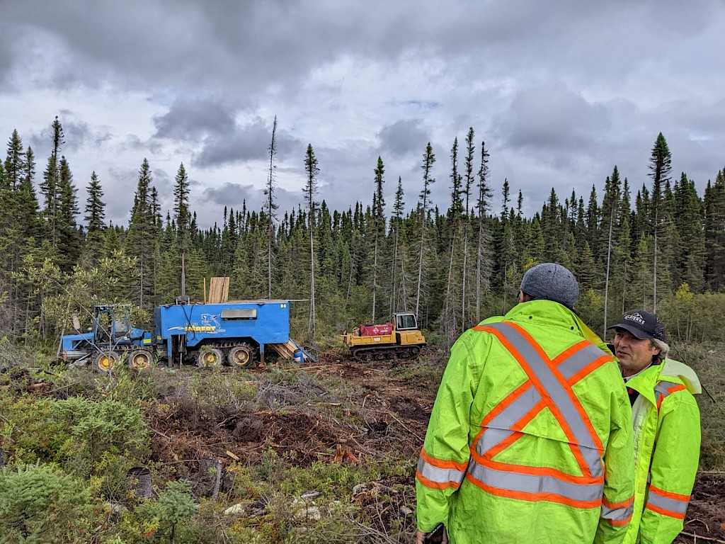
FE Battery Metals (CSE: FE) has released the findings of its 2023 drill program at its flagship Augustus Lithium Property in Quebec, Canada. The results of Drill Hole LC23-50 are particularly noteworthy, as they include multiple sections of lithium mineralization, including a 17.45-meter-wide section with 1.19% lithium oxide (Li2O) at a depth of 82.4 meters. This drill hole was intended to examine the eastward extension of LC21-16, which previously yielded positive results of 1.17% Li2O over 19 meters at a depth of 126 meters.
The company intends to follow up on these findings by conducting additional drilling and constructing 3D models of the lithium-bearing rock formations to gain a better understanding of the geometry of one of the main higher-grade lithium pegmatite zones.
Gurminder Sangha, CEO & Director, commented in a press release: “We are very excited to see such promising drill results at Augustus and are currently endeavouring to define the size and shape of the high-grade zones. With Quebec now a hard rock lithium hotspot, this is a significant milestone for our company. We look forward to further unlocking the potential of Augustus, which is located just a few kilometres from the now-operational North American Lithium Mine.”
Highlights from the results are as follows:
- The main lithium pegmatite zone (pegmatite intercept 4) in Hole LC23-50 is 17.45 m wide with average 5,558 parts per million (ppm) lithium (Li) or 1.19% Li2O at 82.4m drilled depth. In addition, there are anomalous values of other rare metals in this section such as beryllium (Be), cesium (Cs), niobium (Nb), and tantalum (Ta).
- Drill Hole LC23-50 intersected eight lithium pegmatite intercepts as follows:
- Pegmatite intercept 1 with average 1,915 ppm Li or 0.41% Li2O over 1.77 meters at 11.23 m drilled depth.
- Pegmatite intercept 2 with average 1,610 ppm Li or 0.35% Li2O over 2 meters at 25 m drilled depth.
- Pegmatite intercept 3 is a low-grade zone with average 917 ppm Li or 0.20% Li2O over 4.4 meters at 31m drilled depth.
- Pegmatite intercept 4 with average 5,558 ppm Li or 1.19% Li2O over 17.45 meters at 82.85m drilled depth.
- Pegmatite intercept 5 with average 5,099 ppm Li or 1.10% Li2O over 10 meters at 106m drilled depth. This intercept also has a 1.67 m section with 1,700 ppm cesium and 2,030 ppm chromium. Rubidium in two sections is over 5,000 ppm which is above the method detection limits.
- Pegmatite intercept 6 with average 6,625 ppm Li or 1.42% Li2O over 2 meters at 180m drilled depth.
- Pegmatite intercept 7 is a low-grade zone with average 244 ppm Li or 0.05% Li2O over 4 meters at 194m drilled depth.
- Pegmatite intercept 8 with average 3,146 ppm Li or 0.68% Li2O over 8.5 meters at 210m drilled depth.
- All pegmatites have anomalous values of other rare metals.
- All intersections reported are based on drilled width and have not been converted to the true width.
Drill hole LC23-50 was drilled at location 5367757.986 N, 287214.019E, UTM NAD 1983 Zone 18N, at azimuth 51.3 degrees and dip -49.4 with a drilled depth of 252 m. The drill hole was placed at the main Augustus zone.
The drill core is logged and sampled at the core shack using a rock saw. A core shack is built at the village of St-Dominique du Rosaire located about 50km from the Property for drill core logging, sample preparation and storage. For quality control and quality assurance (QA/QC), field duplicates, standards and blanks are being inserted at industry standard intervals. The samples were bagged and tagged using best practices and were delivered to Activation Laboratories (“ACTLABS”), Ancaster, Ontario for sample preparation and analyses using laboratory code Ultratrace 7 and sodium peroxide fusion (Na2O2) as summarized below. ACTLABS is an independent commercial, accredited ISO Certified Laboratory.
The above references an opinion and is for information purposes only. It is not intended to be investment advice. Seek a licensed professional for investment advice. The author is not an insider or shareholder of any of the companies mentioned above.
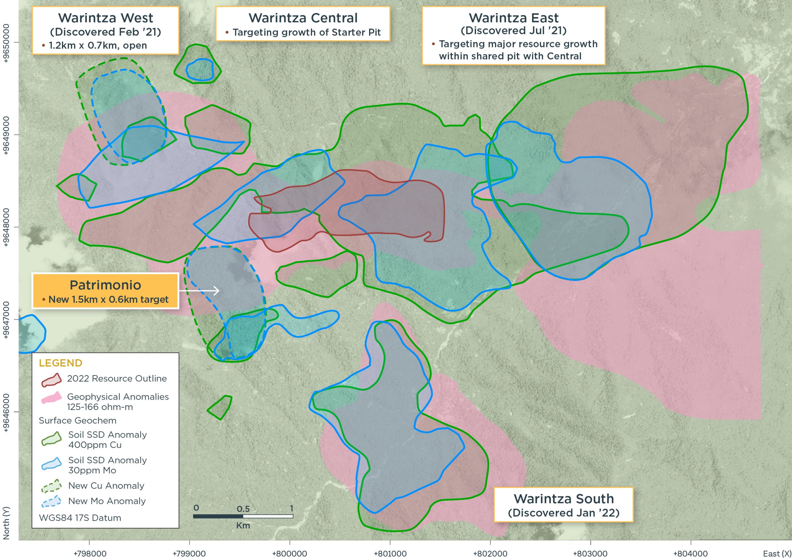
Solaris Resources (TSX:SLS) (OTCQB:SLSSF) has announced a new porphyry discovery at the Warintza porphyry cluster called Patrimonio. The company made the discovery during ongoing field work, immediately southwest of the Warintza Central deposit in southeastern Ecuador.
Mr. Jorge Fierro, Vice President, Exploration, commented in a press release: “As drilling continues to expand the MRE, we have conducted a program of reconnaissance mapping and sampling that extends into previously inaccessible areas. The discoveries made to date within the Warintza cluster were based largely on sampling work that dates back more than 20 years. The aim of this ongoing effort is to identify targets for high value growth, such as at Patrimonio, where we’ve discovered a sizeable porphyry target with potential for high grades close to surface in close proximity to our growing MRE.”
Highlights from the results are as follows:
- Patrimonio was discovered via reconnaissance mapping and sampling in an area that had not previously been accessed southwest of Warintza Central, with the northern extent of the target found just outside the Mineral Resource Estimate (“MRE”)¹ shell (refer to Figure 1)
- Patrimonio is defined by highly anomalous sampling over a 1.5km long x 0.6km wide area where outcropping porphyritic diorite displays intense, pervasive biotite alteration and stockwork veining on the western side of a major north-south fault adjacent to Warintza Central
- Rock chip samples from weathered outcrop at Patrimonio returned values of up to 1.6% copper (“Cu”) (averaging 0.18% Cu), 630 parts per million (“ppm”) molybdenum (“Mo”) (averaging 104 ppm Mo) and 0.16 grams per tonne (“g/t”) gold (“Au”) (averaging 0.1 g/t Au)
- Soil samples at Patrimonio average 764 ppm Cu and 89 ppm Mo, comparable in copper values to Warintza East (887 ppm Cu, 87 ppm Mo) and Warintza Central (816 ppm Cu, 288 ppm Mo), with lower molybdenum values than Central
- Together with high-level alteration assemblages observed in outcrop, this metal zonation implies Patrimonio is better preserved/less eroded than Central on the opposite side of the fault, but with similar stockwork veining suggesting the porphyry may be well mineralized
- Field crews have established locations for the construction of an initial four drilling platforms in the northern half of Patrimonio, with the first drill hole at the northernmost platform expected to commence later this month
- MRE drilling program continues: the 2022 MRE is based on drilling to the end of 2021, with ongoing drilling aimed at expanding the ‘Indicative Starter Pit’² and overall mineral resources
Patrimonio
Field crews have discovered conspicuous copper and molybdenum in outcrop (refer to Figures 2-5) where the mineralized rock is a porphyritic diorite that displays intense, pervasive biotite alteration and stockwork veining. This compares to Warintza Central where the host rock is a quartz monzodiorite stock, and Warintza East, where most of the mineralization is in a volcano-sedimentary sequence around a porphyry stock, with a second stock recently located to the south. At Warintza West, mineralization is hosted by dacite porphyry that intrudes diorite and granodiorite.
Quartz-molybdenum or “B-veins” that typically occupy the core of porphyries at Warintza, were encountered at surface at Patrimonio. The highest part of the Patrimonio target, exposed on a hilltop, contains galena and sphalerite in a relatively low-temperate alteration mineral assemblage that is typically located above and lateral to porphyries. The presence of these minerals implies that the porphyry has been minimally eroded and is well-preserved.
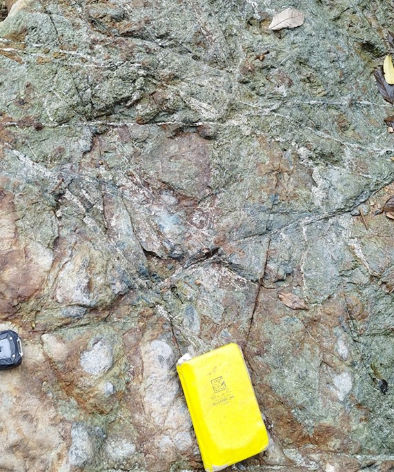
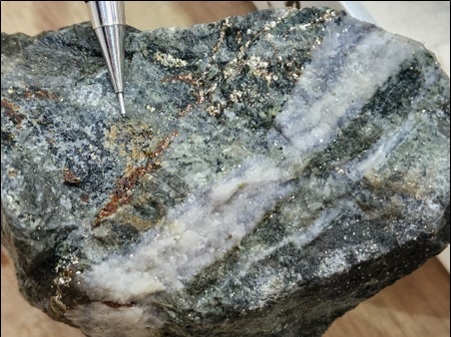
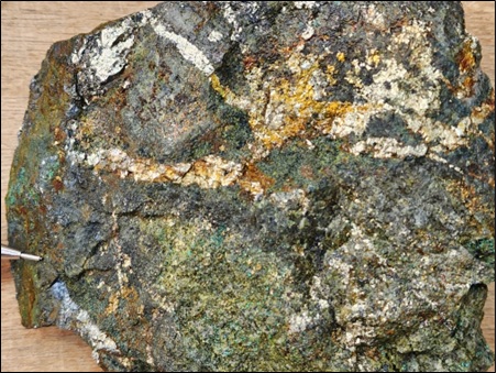
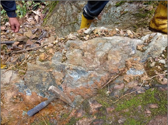
The above references an opinion and is for information purposes only. It is not intended to be investment advice. Seek a licensed professional for investment advice. The author is not an insider or shareholder of any of the companies mentioned above.
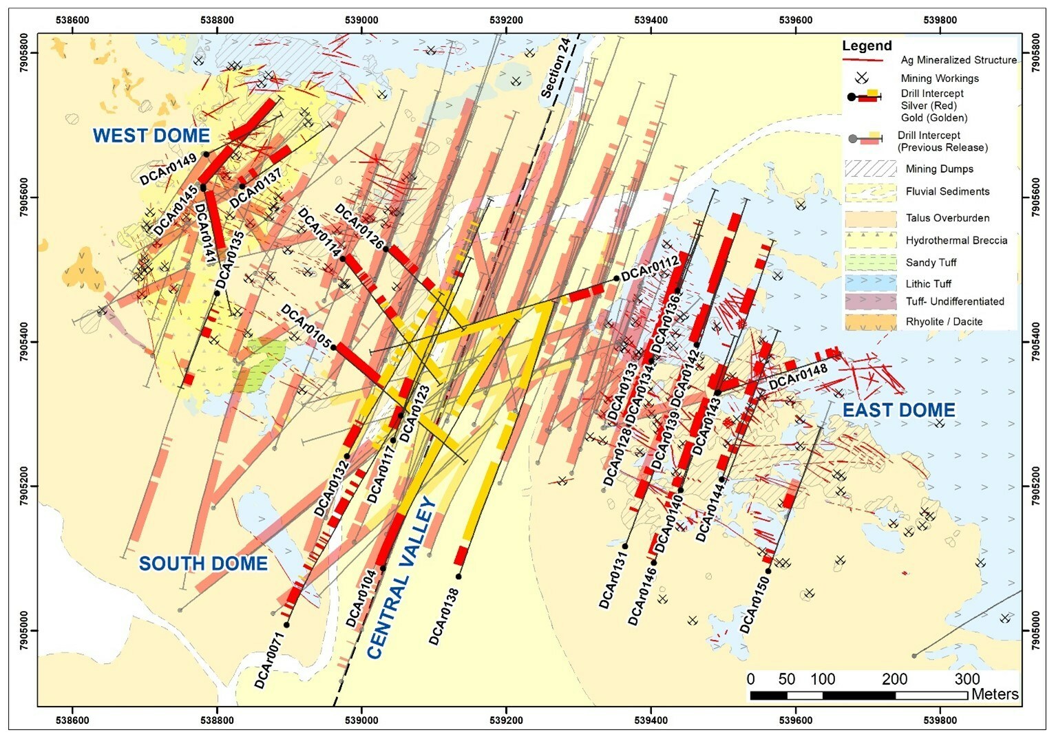
New Pacific Metals (TSX:NUAG) has announced the latest assay results of the 2022 drill program at its Carangas Silver-Gold Project, located in the Oruro Department of Bolivia. The company, along with its Bolivian partner, reported that assay results of all 115 drill holes drilled in 2022 have been received and released.
According to the detailed results and drill hole specifications listed in Tables 1 and 2, as well as in Figure 1, of the 29 holes, ten were deep holes drilled in different directions towards the Central Valley to define the limit of the gold mineralization system at depth. The drill results show that the gold system is open to the north and north-east directions with these targets currently being drill tested as part of the Company’s Q1 2023 drill program.
The remaining 19 holes were shallow and were drilled to define the near-surface silver mineralization. All nineteen holes intersected silver mineralization. These results demonstrate the significant potential of the Carangas Project for silver and gold mineralization.
In addition to the drilling activities, the results of an expanded 3D Bipole-Dipole IP-MT survey program completed in January 2023 have been received. The survey showed multiple chargeability anomalies outside the current area of drilling (seen in Figure 2). These new chargeability anomalies display a similar geophysical signature to those of the known silver-gold system and will be drill tested in future drilling campaigns.
The Carangas Project is a key project for New Pacific Metals Corp. and the latest assay results are an important milestone in the exploration and development of the project. With these positive results, the company is looking forward to future drilling campaigns and advancing the Carangas Project towards production.
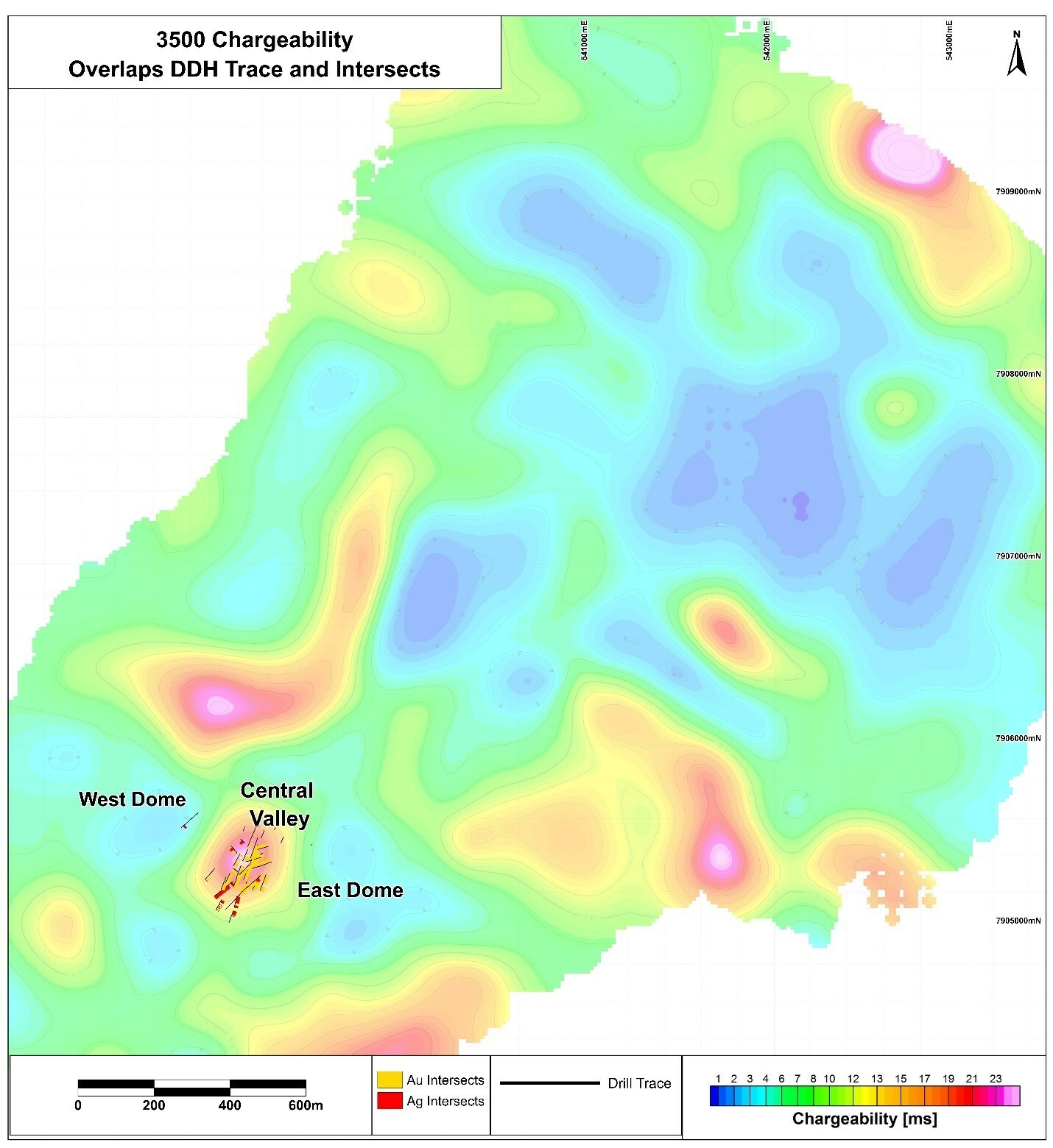
Highlights from the results are as follows:
DCAr0112 intersected a gold mineralization interval of 306.95 m at depth from 359.55 m to 666.5 m, grading 1.2 g/t Au and 26 g/t Ag, including 31.78 m (411.65 m to 443.43 m) grading 122 g/t Ag, 4.11 g/t Au and 0.15% Cu, and near surface silver mineralization intervals of 41.03 m (55.97 m to 97 m) grading 54 g/t Ag, 0.25% Pb and 0.57% Zn, and 75.1 m (108.7 m to 183.8 m) grading 27 g/t Ag, 0.24%Pb and 0.65% Zn.
DCAr0104 intersected a gold mineralization interval of 328.3 m (233.75 m to 562.05 m) grading, 1.07 g/t Au, 20 g/t Ag ,0.14% Pb, 0.25% Zn and 0.14% copper (“Cu”), and a near surface silver-lead-zinc mineralization interval of 228.25 m (5.5 m to 233.75 m) grading 21 g/t silver (“Ag”), 0.54% lead (“Pb”) and 1.23% zinc (“Zn”), immediately followed by. Two more gold mineralization intervals intersected at further depth, 15.77 m (652.17 m to 667.94 m) grading 0.44 g/t Au and 0.12% Cu, and 252 m (693 m to 945 m) grading 0.45 g/t Au and 0.13% Cu.
DCAr0105 intersected a gold mineralization interval of 476.3 m (324.7 m to 801 m) grading 0.75g/t Au including 43.62 m (510.38 m to 554 m) grading 3.19 g/t Au, and a near surface silver-lead-zinc mineralization interval of 293.94 m (5.16 m to 299.1 m) grading 37 g/t Ag, 0.57% lead (“Pb”) and 1.3% zinc (“Zn”), including 38.99 m (5.16 m to 44.15 m) grading 134 g/t Ag, 1.48% Pb and 2.51% Zn.
Highlights of drill results for shallow holes
DCAr0141 intersected a near surface silver-lead-zinc mineralization interval of 110.15 m (5.85 m to 116 m) grading 136 g/t Ag and 0.96% Pb, including 6.92 m (30.73 m to 37.65 m) grading 693 g/t Ag and 1.71% Pb, and 24.63 m (59.87 m to 84.5 m) grading 197 g/t Ag and 2.14% Pb. Multiple historical underground mining voids for a total length of 16.39 m were intersected in this hole.
DCAr0128 intersected a near surface silver-lead-zinc mineralization interval of 78.3 m (7.7 m to 86 m) grading 104 g/t Ag, 0.74% Pb and 0.59% Zn including 33 m (30.5 m to 60.5 m) grading 226 g/t Ag, 1.47% Pb and 0.93% Zn. In addition, further down the hole to the end of hole, multiple shorter silver-lead-zinc mineralization intervals were intercepted.
DCAr0134 intersected 111.85 m (114.4 m to 226.25 m) grading 52 g/t Ag, 0.25% Pb and 0.59% Zn including 17.94 m (198.96 m to 216.9 m) grading 197 g/t Ag, 0.49% Pb and 0.91% Zn.
Update on Q1 2023 Resource Drill Program
The Company’s 2023 15,000 m drill program at Carangas is close to being completed. The results from this drill program, together with the results from 2021 and 2022 drilling, will be used to estimate an inaugural mineral resource to be completed in the second quarter of 2023.
Expanded IP survey program
A pilot 3D Bipole-Dipole IP-MT survey program was completed in the drilled area of West Dome-Central Valley-East Dome in September 2022 (refer to the Company’s news release dated on November 14, 2022), revealing that the blind gold mineralization system at the Central Valley overlays the strongest chargeability anomaly under the young sediments of the Central Valley.
Encouraged by the success of the pilot 3D Bipole-Dipole IP-MT survey program, an expanded 3D Bipole-Dipole IP-MT survey program was carried out at Carangas by Southern Rock Geophysics S.A. of Chile from November 2022 to January 2023. This expanded IP program covers the entire Carangas Basin of 29 square kilometers, which is mostly covered by young sediments.
Multiple high chargeability anomalies with a similar signature to that of the Central Velley were identified in the expanded area outside of the drilled area (Figure 2). These new anomalies generally have weak or no chargeability response near surface, but high chargeability starts to show from 200 m depth to more than 800 m depth from surface. These deep high chargeability anomalies may be related to sulfide mineralization at depth, which may be related to rhyolite intrusive bodies, like those seen in the Central Valley. These anomalies, such as those to the north of the Central Valley (Figure 2), will be drill targets in future exploration programs.
| Table 1 Summary of Drill Intercepts | ||||||||||
| Hole_ID | Form | To | Length_m | Ag_g/t | Au_g/t | Pb_% | Zn_% | Cu_% | AgEq_g/t | |
| DCAr0071 | 33.22 | 44.35 | 11.13 | 16 | 0.01 | 0.10 | 0.36 | 0.01 | 32 | |
| 70.58 | 82.79 | 12.21 | 22 | 0.10 | 0.27 | 0.01 | 34 | |||
| 94.23 | 164.40 | 70.17 | 29 | 0.01 | 0.24 | 0.54 | 0.01 | 55 | ||
| 175.70 | 191.33 | 15.63 | 18 | 0.03 | 0.18 | 0.35 | 37 | |||
| 211.83 | 220.36 | 8.53 | 61 | 0.58 | 0.36 | 0.62 | 0.01 | 135 | ||
| 263.98 | 278.90 | 14.92 | 5 | 0.02 | 0.32 | 0.52 | 0.01 | 34 | ||
| 286.64 | 290.00 | 3.36 | 11 | 0.62 | 0.84 | 1.55 | 0.01 | 132 | ||
| 306.30 | 310.17 | 3.87 | 10 | 0.12 | 0.93 | 1.85 | 107 | |||
| 316.71 | 326.80 | 10.09 | 6 | 0.08 | 0.50 | 0.83 | 54 | |||
| 338.35 | 345.70 | 7.35 | 7 | 0.06 | 0.48 | 0.84 | 0.01 | 55 | ||
| 374.70 | 391.10 | 16.40 | 5 | 0.09 | 0.24 | 0.43 | 0.04 | 37 | ||
| 405.80 | 409.64 | 3.84 | 4 | 0.04 | 0.38 | 0.86 | 0.02 | 49 | ||
| 415.85 | 422.97 | 7.12 | 5 | 0.08 | 0.47 | 0.87 | 0.01 | 55 | ||
| 439.62 | 449.24 | 9.62 | 3 | 0.08 | 0.35 | 0.53 | 37 | |||
| 485.10 | 529.44 | 44.34 | 2 | 0.16 | 0.08 | 0.77 | 42 | |||
| 548.00 | 614.43 | 66.43 | 3 | 0.03 | 0.12 | 0.65 | 0.01 | 31 | ||
| 634.80 | 650.24 | 15.44 | 3 | 0.11 | 0.09 | 0.44 | 0.03 | 31 | ||
| 671.40 | 684.60 | 13.20 | 6 | 0.19 | 0.01 | 0.07 | 0.15 | 38 | ||
| 709.76 | 735.78 | 26.02 | 5 | 0.01 | 0.05 | 1.13 | 0.07 | 52 | ||
| 825.75 | 843.70 | 17.95 | 13 | 0.18 | 0.49 | 0.02 | 0.36 | 78 | ||
| 861.50 | 870.40 | 8.90 | 6 | 0.41 | 0.01 | 0.01 | 36 | |||
| 892.21 | 915.80 | 23.59 | 7 | 0.52 | 0.01 | 0.01 | 0.08 | 53 | ||
| 983.18 | 996.57 | 13.39 | 7 | 0.15 | 0.01 | 0.33 | 52 | |||
| 1047.82 | 1055.00 | 7.18 | 4 | 0.18 | 0.01 | 0.14 | 32 | |||
| 1067.00 | 1079.85 | 12.85 | 6 | 0.10 | 0.01 | 0.01 | 0.20 | 35 | ||
| 1090.48 | 1100.00 | 9.52 | 3 | 0.04 | 0.01 | 0.19 | 25 | |||
| DCAr0104 | 5.50 | 233.75 | 228.25 | 21 | 0.05 | 0.54 | 1.23 | 0.02 | 83 | |
| 233.75 | 562.05 | 328.30 | 20 | 1.07 | 0.14 | 0.25 | 0.14 | 123 | ||
| 652.17 | 667.94 | 15.77 | 3 | 0.44 | 0.01 | 0.03 | 0.12 | 48 | ||
| 693.00 | 945.00 | 252.00 | 3 | 0.45 | 0.01 | 0.13 | 49 | |||
| 957.30 | 1018.96 | 61.66 | 5 | 0.07 | 0.01 | 0.20 | 31 | |||
| DCAr0105 | 5.16 | 299.10 | 293.94 | 37 | 0.08 | 0.57 | 1.30 | 0.03 | 106 | |
| incl. | 5.16 | 44.15 | 38.99 | 134 | 0.01 | 1.48 | 2.51 | 0.01 | 262 | |
| 324.70 | 801.00 | 476.30 | 4 | 0.75 | 0.02 | 0.08 | 0.07 | 68 | ||
| incl. | 510.38 | 554.00 | 43.62 | 6 | 3.19 | 0.02 | 0.04 | 0.10 | 245 | |
| DCAr0112 | 55.97 | 97.00 | 41.03 | 54 | 0.01 | 0.25 | 0.57 | 0.01 | 81 | |
| 108.70 | 183.80 | 75.10 | 27 | 0.01 | 0.24 | 0.65 | 0.02 | 58 | ||
| 195.40 | 215.44 | 20.04 | 6 | 0.11 | 0.60 | 0.58 | 51 | |||
| 247.66 | 309.78 | 62.12 | 4 | 0.12 | 0.10 | 0.28 | 0.03 | 28 | ||
| 359.55 | 666.50 | 306.95 | 26 | 1.19 | 0.03 | 0.07 | 0.06 | 120 | ||
| incl. | 411.65 | 443.43 | 31.78 | 122 | 4.11 | 0.09 | 0.14 | 0.15 | 437 | |
| 694.98 | 722.50 | 27.52 | 2 | 0.18 | 0.00 | 0.25 | 24 | |||
| 750.00 | 775.00 | 25.00 | 5 | 0.17 | 0.06 | 0.78 | 0.04 | 49 | ||
| DCAr0114 | 0.00 | 119.70 | 119.70 | 42 | 0.60 | 1.22 | 0.01 | 101 | ||
| 135.50 | 141.35 | 5.85 | 22 | 0.07 | 0.23 | 32 | ||||
| 148.45 | 173.80 | 25.35 | 30 | 0.14 | 0.33 | 0.01 | 46 | |||
| 188.29 | 195.30 | 7.01 | 36 | 0.08 | 0.17 | 44 | ||||
| 206.90 | 212.20 | 5.30 | 49 | 0.02 | 0.12 | 0.26 | 0.01 | 63 | ||
| 230.90 | 262.34 | 31.44 | 8 | 0.03 | 0.32 | 0.73 | 0.01 | 45 | ||
| 313.00 | 350.18 | 37.18 | 2 | 0.02 | 0.16 | 0.47 | 0.01 | 25 | ||
| 358.65 | 382.64 | 23.99 | 5 | 0.30 | 0.12 | 0.64 | 0.07 | 59 | ||
| 395.48 | 458.67 | 63.19 | 4 | 0.07 | 0.20 | 0.63 | 0.03 | 38 | ||
| 468.70 | 528.43 | 59.73 | 10 | 0.31 | 0.08 | 0.20 | 0.06 | 47 | ||
| 539.91 | 548.60 | 8.69 | 5 | 0.39 | 0.05 | 0.24 | 0.08 | 50 | ||
| 558.40 | 562.65 | 4.25 | 4 | 0.68 | 0.02 | 0.11 | 0.05 | 61 | ||
| 571.18 | 576.90 | 5.72 | 4 | 0.02 | 0.35 | 0.88 | 0.01 | 45 | ||
| 591.30 | 623.70 | 32.40 | 3 | 0.12 | 0.13 | 0.72 | 0.01 | 41 | ||
| 646.09 | 648.94 | 2.85 | 0 | 2.47 | 0.00 | 0.03 | 177 | |||
| 666.50 | 678.43 | 11.93 | 2 | 0.34 | 0.00 | 0.01 | 0.11 | 38 | ||
| 684.20 | 706.85 | 22.65 | 2 | 0.49 | 0.01 | 0.01 | 0.03 | 41 | ||
| 713.92 | 824.20 | 110.28 | 4 | 0.98 | 0.01 | 0.01 | 0.17 | 92 | ||
| 840.00 | 854.00 | 14.00 | 10 | 0.67 | 0.01 | 0.01 | 0.45 | 105 | ||
| DCAr0117 | 45.18 | 137.96 | 92.78 | 23 | 0.03 | 0.31 | 0.64 | 0.04 | 60 | |
| 147.62 | 169.35 | 21.73 | 6 | 0.11 | 0.12 | 0.50 | 0.07 | 42 | ||
| 188.86 | 347.22 | 158.36 | 11 | 0.51 | 0.19 | 0.18 | 0.06 | 64 | ||
| 382.78 | 426.00 | 43.22 | 17 | 0.95 | 0.03 | 0.07 | 0.10 | 97 | ||
| 457.70 | 480.63 | 22.93 | 11 | 0.49 | 0.03 | 0.12 | 0.08 | 59 | ||
| 496.48 | 507.00 | 10.52 | 8 | 0.28 | 0.02 | 0.08 | 0.05 | 36 | ||
| 529.75 | 649.81 | 120.06 | 8 | 0.68 | 0.01 | 0.08 | 0.06 | 66 | ||
| 714.69 | 732.50 | 17.81 | 7 | 0.06 | 0.25 | 0.87 | 0.23 | 71 | ||
| DCAr0123 | 54.76 | 115.90 | 61.14 | 31 | 0.04 | 0.28 | 0.99 | 0.05 | 81 | |
| 124.50 | 284.32 | 159.82 | 11 | 0.11 | 0.42 | 0.97 | 0.05 | 68 | ||
| 330.13 | 393.67 | 63.54 | 14 | 0.60 | 0.03 | 0.12 | 0.02 | 63 | ||
| 417.59 | 434.12 | 16.53 | 12 | 0.20 | 0.06 | 0.17 | 0.22 | 56 | ||
| 487.45 | 502.30 | 14.85 | 2 | 0.11 | 0.05 | 0.35 | 0.03 | 27 | ||
| 513.42 | 517.55 | 4.13 | 9 | 2.58 | 0.12 | 1.23 | 0.01 | 237 | ||
| 544.75 | 548.91 | 4.16 | 5 | 0.22 | 0.85 | 1.19 | 0.00 | 85 | ||
| 574.77 | 577.43 | 2.66 | 4 | 0.29 | 0.37 | 0.99 | 0.02 | 71 | ||
| 590.38 | 597.14 | 6.76 | 3 | 0.11 | 0.36 | 0.90 | 0.01 | 53 | ||
| DCAr0126 | 19.10 | 188.06 | 168.96 | 40 | 0.37 | 1.19 | 0.01 | 92 | ||
| incl. | 31.20 | 58.07 | 26.87 | 120 | 0.99 | 4.03 | 0.04 | 288 | ||
| 196.70 | 201.05 | 4.35 | 14 | 0.04 | 0.26 | 0.57 | 0.00 | 43 | ||
| 223.30 | 229.18 | 5.88 | 3 | 0.05 | 0.37 | 0.76 | 0.00 | 43 | ||
| 238.00 | 296.43 | 58.43 | 5 | 0.02 | 0.34 | 0.71 | 0.00 | 40 | ||
| 395.95 | 491.00 | 95.05 | 3 | 0.09 | 0.14 | 0.52 | 0.03 | 34 | ||
| 522.97 | 545.15 | 22.18 | 9 | 0.22 | 0.05 | 0.30 | 0.12 | 48 | ||
| 568.00 | 579.17 | 11.17 | 8 | 0.68 | 0.07 | 0.35 | 0.01 | 71 | ||
| 589.15 | 601.00 | 11.85 | 13 | 0.81 | 0.00 | 0.04 | 0.08 | 80 | ||
| 627.03 | 629.95 | 2.92 | 2 | 1.02 | 0.00 | 0.03 | 0.03 | 78 | ||
| 638.41 | 646.85 | 8.44 | 11 | 1.06 | 0.00 | 0.01 | 0.09 | 97 | ||
| 699.00 | 848.00 | 149.00 | 3 | 0.80 | 0.00 | 0.02 | 0.09 | 70 | ||
| DCAr0128 | 7.70 | 86.00 | 78.30 | 104 | 0.74 | 0.59 | 0.01 | 146 | ||
| incl. | 30.50 | 63.50 | 33.00 | 226 | 1.47 | 0.93 | 0.01 | 301 | ||
| 100.80 | 103.80 | 3.00 | 9 | 0.13 | 1.59 | 0.01 | 66 | |||
| 120.00 | 148.80 | 28.80 | 17 | 0.17 | 0.62 | 43 | ||||
| 179.87 | 209.93 | 30.06 | 7 | 0.17 | 0.51 | 0.02 | 32 | |||
| 220.31 | 228.40 | 8.09 | 114 | 0.87 | 0.58 | 0.01 | 159 | |||
| 236.86 | 243.30 | 6.44 | 31 | 0.50 | 0.68 | 0.01 | 69 | |||
| 263.80 | 278.05 | 14.25 | 31 | 0.20 | 0.33 | 48 | ||||
| 282.55 | 288.55 | 6.00 | 3 | 0.57 | 0.41 | 34 | ||||
| DCAr0131 | 70.18 | 75.89 | 5.71 | 66 | 0.04 | 0.19 | 68 | |||
| 96.79 | 133.20 | 36.41 | 51 | 0.86 | 0.59 | 0.03 | 81 | |||
| 146.13 | 159.74 | 13.61 | 45 | 0.13 | 0.17 | 0.01 | 50 | |||
| 212.00 | 239.80 | 27.80 | 32 | 0.36 | 0.65 | 0.01 | 47 | |||
| 257.20 | 262.50 | 5.30 | 38 | 0.77 | 0.82 | 63 | ||||
| DCAr0132 | 35.50 | 128.56 | 93.06 | 28 | 0.11 | 0.40 | 0.93 | 0.05 | 83 | |
| 140.57 | 148.80 | 8.23 | 5 | 0.03 | 0.19 | 0.70 | 0.03 | 39 | ||
| 176.15 | 265.52 | 89.37 | 10 | 0.41 | 0.29 | 0.39 | 0.06 | 67 | ||
| 288.29 | 293.80 | 5.51 | 4 | 0.52 | 0.04 | 0.04 | 0.03 | 47 | ||
| 314.60 | 401.48 | 86.88 | 7 | 0.41 | 0.04 | 0.30 | 0.04 | 51 | ||
| 420.23 | 435.80 | 15.57 | 12 | 0.24 | 0.07 | 0.53 | 0.07 | 56 | ||
| 448.15 | 474.77 | 26.62 | 4 | 0.37 | 0.04 | 0.08 | 0.01 | 35 | ||
| 500.50 | 504.50 | 4.00 | 4 | 0.86 | 0.05 | 0.08 | 0.04 | 74 | ||
| 518.70 | 552.80 | 34.10 | 3 | 1.32 | 0.02 | 0.07 | 0.02 | 102 | ||
| 566.18 | 587.45 | 21.27 | 9 | 0.30 | 0.03 | 0.26 | 0.03 | 42 | ||
| 617.62 | 647.80 | 30.18 | 2 | 0.36 | 0.11 | 0.29 | 0.00 | 41 | ||
| 689.95 | 740.00 | 50.05 | 2 | 0.21 | 0.04 | 0.34 | 0.01 | 30 | ||
| DCAr0133 | 13.50 | 20.50 | 7.00 | 64 | 0.31 | 0.13 | 77 | |||
| 77.00 | 79.60 | 2.60 | 29 | 0.61 | 1.04 | 82 | ||||
| 104.95 | 112.21 | 7.26 | 16 | 0.43 | 1.20 | 0.01 | 70 | |||
| 122.22 | 185.26 | 63.04 | 26 | 0.13 | 0.47 | 0.01 | 47 | |||
| 196.78 | 225.40 | 28.62 | 15 | 0.22 | 0.51 | 0.04 | 42 | |||
| 259.70 | 261.00 | 1.30 | 174 | 0.13 | 0.38 | 0.05 | 195 | |||
| 273.38 | 277.26 | 3.88 | 39 | 0.10 | 0.29 | 51 | ||||
| 310.00 | 311.30 | 1.30 | 1200 | 3.64 | 2.94 | 0.04 | 1408 | |||
| DCAr0134 | 3.03 | 40.60 | 37.57 | 11 | 0.43 | 0.14 | 28 | |||
| 114.40 | 226.25 | 111.85 | 52 | 0.25 | 0.59 | 0.01 | 80 | |||
| incl. | 198.96 | 216.90 | 17.94 | 197 | 0.49 | 0.91 | 0.04 | 245 | ||
| DCAr0135 | 32.20 | 35.79 | 3.59 | 35 | 0.15 | 0.01 | 40 | |||
| 47.00 | 54.00 | 7.00 | 21 | 0.36 | 0.01 | 0.01 | 32 | |||
| 70.27 | 89.00 | 18.73 | 13 | 0.40 | 0.01 | 0.01 | 27 | |||
| 169.00 | 187.72 | 18.72 | 4 | 0.09 | 0.71 | 0.01 | 31 | |||
| DCAr0136 | 1.15 | 28.00 | 26.85 | 115 | 0.36 | 0.16 | 0.01 | 132 | ||
| 59.50 | 63.99 | 4.49 | 92 | 0.10 | 0.13 | 0.01 | 100 | |||
| 130.43 | 133.16 | 2.73 | 78 | 0.13 | 0.20 | 88 | ||||
| DCAr0137 | 1.28 | 11.50 | 10.22 | 14 | 0.48 | 0.04 | 0.01 | 30 | ||
| 25.33 | 35.80 | 10.47 | 19 | 0.21 | 0.02 | 26 | ||||
| 70.86 | 113.30 | 42.44 | 5 | 0.19 | 1.52 | 0.01 | 63 | |||
| 144.58 | 145.90 | 1.32 | 117 | 0.39 | 0.75 | 0.02 | 155 | |||
| DCAr0138 | 36.50 | 99.00 | 62.50 | 33 | 0.02 | 0.37 | 1.33 | 0.02 | 92 | |
| 125.00 | 403.28 | 278.28 | 6 | 0.13 | 0.30 | 0.80 | 0.02 | 52 | ||
| 450.40 | 530.49 | 80.09 | 4 | 0.81 | 0.06 | 0.23 | 0.04 | 74 | ||
| 546.47 | 571.00 | 24.53 | 2 | 0.61 | 0.02 | 0.03 | 0.05 | 52 | ||
| 648.05 | 902.00 | 253.95 | 11 | 1.00 | 0.01 | 0.07 | 0.03 | 87 | ||
| DCAr0139 | 6.20 | 7.40 | 1.20 | 89 | 0.14 | 0.08 | 96 | |||
| 14.10 | 35.92 | 21.82 | 12 | 0.28 | 0.23 | 28 | ||||
| 44.20 | 81.80 | 37.60 | 31 | 0.22 | 0.71 | 0.01 | 62 | |||
| 143.25 | 149.00 | 5.75 | 12 | 0.26 | 0.47 | 35 | ||||
| 158.67 | 208.09 | 49.42 | 17 | 0.24 | 0.72 | 0.01 | 49 | |||
| 231.50 | 253.20 | 21.70 | 34 | 0.26 | 0.28 | 0.02 | 52 | |||
| 292.60 | 298.72 | 6.12 | 30 | 0.07 | 0.11 | 36 | ||||
| DCAr0140 | 2.79 | 5.66 | 2.87 | 64 | 0.06 | 0.20 | 73 | |||
| 12.96 | 24.00 | 11.04 | 41 | 0.53 | 0.18 | 0.01 | 63 | |||
| 107.79 | 189.00 | 81.21 | 54 | 0.23 | 0.43 | 0.01 | 75 | |||
| 211.32 | 239.30 | 27.98 | 65 | 0.43 | 0.66 | 0.01 | 101 | |||
| 298.92 | 302.45 | 3.53 | 222 | 0.85 | 1.79 | 0.01 | 307 | |||
| DCAr0141 | 5.85 | 116.00 | 110.15 | 136 | 0.96 | 0.02 | 165 | |||
| incl. | 30.73 | 37.65 | 6.92 | 693 | 1.71 | 0.02 | 0.01 | 744 | ||
| incl. | 59.87 | 84.5 | 24.63 | 197 | 2.14 | 0.01 | 0.01 | 260 | ||
| DCAr0142 | 2.75 | 57.65 | 54.90 | 37 | 0.23 | 0.14 | 49 | |||
| 68.64 | 72.05 | 3.41 | 61 | 0.24 | 0.13 | 73 | ||||
| 122.00 | 218.70 | 96.70 | 36 | 0.15 | 0.25 | 49 | ||||
| incl. | 126.48 | 131.40 | 4.92 | 280 | 0.27 | 0.28 | 0.01 | 299 | ||
| 233.00 | 268.20 | 35.20 | 128 | 0.22 | 0.10 | 0.01 | 139 | |||
| incl. | 252.00 | 260.70 | 8.70 | 458 | 0.65 | 0.09 | 0.04 | 484 | ||
| DCAr0143 | 2.00 | 53.40 | 51.40 | 32 | 0.30 | 0.13 | 46 | |||
| 160.01 | 209.62 | 49.61 | 70 | 0.16 | 0.34 | 86 | ||||
| 252.52 | 270.60 | 18.08 | 67 | 0.20 | 0.33 | 0.01 | 85 | |||
| 278.00 | 279.33 | 1.33 | 420 | 0.74 | 0.09 | 0.04 | 449 | |||
| 291.00 | 299.62 | 8.62 | 59 | 0.11 | 0.15 | 68 | ||||
| DCAr0144 | 17.10 | 45.92 | 28.82 | 98 | 0.31 | 0.26 | 0.01 | 117 | ||
| 174.00 | 204.25 | 30.25 | 83 | 0.42 | 0.46 | 0.01 | 111 | |||
| 221.70 | 242.35 | 20.65 | 21 | 0.33 | 0.29 | 0.01 | 41 | |||
| 250.78 | 281.00 | 30.22 | 54 | 0.08 | 0.10 | 0.01 | 60 | |||
| DCAr0145 | 2.24 | 86.70 | 84.46 | 25 | 0.51 | 0.43 | 0.01 | 55 | ||
| 107.30 | 203.40 | 96.10 | 35 | 0.24 | 0.40 | 0.01 | 57 | |||
| incl. | 147.93 | 157.20 | 9.27 | 173 | 0.80 | 0.77 | 0.07 | 230 | ||
| DCAr0146 | 5.00 | 7.30 | 2.30 | 91 | 0.14 | 0.06 | 0.01 | 98 | ||
| 14.99 | 56.18 | 41.19 | 15 | 0.66 | 0.16 | 40 | ||||
| 111.57 | 122.15 | 10.58 | 25 | 0.20 | 0.37 | 0.01 | 44 | |||
| 130.54 | 143.00 | 12.46 | 12 | 0.19 | 0.41 | 0.01 | 32 | |||
| 154.70 | 169.64 | 14.94 | 102 | 0.14 | 0.11 | 0.01 | 110 | |||
| 190.75 | 245.95 | 55.20 | 20 | 0.20 | 0.39 | 0.01 | 39 | |||
| 263.20 | 304.60 | 41.40 | 7 | 0.27 | 0.40 | 29 | ||||
| DCAr0147 | 2.60 | 29.43 | 26.83 | 26 | 0.56 | 0.17 | 35 | |||
| 157.72 | 172.27 | 14.55 | 32 | 0.32 | 0.30 | 0.01 | 52 | |||
| 189.71 | 190.90 | 1.19 | 156 | 0.98 | 0.23 | 0.03 | 195 | |||
| 198.39 | 221.00 | 22.61 | 16 | 0.39 | 0.16 | 0.01 | 34 | |||
| 227.00 | 239.95 | 12.95 | 10 | 0.78 | 0.20 | 0.01 | 40 | |||
| 248.80 | 253.90 | 5.10 | 43 | 0.15 | 0.16 | 0.01 | 54 | |||
| 264.00 | 274.50 | 10.50 | 83 | 0.11 | 0.19 | 0.02 | 94 | |||
| DCAr0148 | 1.54 | 45.50 | 43.96 | 99 | 0.44 | 0.12 | 116 | |||
| 128.57 | 130.00 | 1.43 | 148 | 0.07 | 0.12 | 154 | ||||
| 140.50 | 161.00 | 20.50 | 56 | 0.16 | 0.46 | 0.01 | 77 | |||
| 201.74 | 210.50 | 8.76 | 26 | 0.39 | 0.59 | 0.05 | 62 | |||
| 222.50 | 235.57 | 13.07 | 104 | 0.44 | 0.13 | 0.02 | 123 | |||
| 241.65 | 247.43 | 5.78 | 31 | 0.28 | 0.15 | 0.01 | 46 | |||
| DCAr0149 | 52.91 | 108.56 | 55.65 | 5 | 1.07 | 0.47 | 0.02 | 54 | ||
| DCAr0150 | 14.45 | 25.90 | 11.45 | 14 | 0.45 | 0.07 | 0.01 | 30 | ||
| 34.52 | 40.90 | 6.38 | 10 | 0.33 | 0.10 | 0.01 | 24 | |||
| 53.53 | 56.15 | 2.62 | 29 | 0.65 | 0.23 | 0.01 | 56 | |||
| 127.49 | 155.00 | 27.51 | 5 | 0.30 | 0.97 | 47 | ||||
| Notes: |
| 1. Drill location, altitude, azimuth, and dip of drill holes are provided in Table 2 |
| 2. Drill intercept is core length, and grade is length weighted. True width of mineralization is unknown due to early stage of exploration without adequate drill data. |
| 3. Calculation of silver equivalent (“AgEq”) is based on the long-term median of the August 2021 Street Consensus Commodity Price Forecasts, which are US$22.50/oz for Ag, US$0.95/lb for Pb, US$1.10/lb for Zn, US$3.40/lb for Cu, and US$1,600/oz for Au. The formula used for the AgEq calculation is as follows: AgEq = Ag g/t + Pb g/t * 0.0029 + Zn g/t * 0.00335 + Cu g/t * 0.01036 + Au g/t * 71.1111. This calculation assumes 100% recovery. |
| 4. A cut-off of 20 g/t AgEq is applied to calculate the length-weighted intercept. At times, samples lower than 20 g/t AgEq may be included in the calculation of consolidation of mineralized intercepts. |
| Table 2 Summary of Drill Holes of Carangas Project | |||||||
| Hole_id | Easting | Northing | Altitude | Depth_m | Azimuth (°) | Dip (°) | Target |
| DCAr0071 | 538895.96 | 7905008.03 | 3906.95 | 1100.00 | 20 | -70 | |
| DCAr0104 | 539029.50 | 7905086.20 | 3904.89 | 1026.00 | 20 | -70 | CV |
| DCAr0105 | 538960.67 | 7905391.94 | 3916.03 | 902.00 | 130 | -72 | CV |
| DCAr0112 | 539352.10 | 7905487.62 | 3909.28 | 908.00 | 252 | -67 | CV |
| DCAr0114 | 538973.57 | 7905514.92 | 3947.33 | 854.00 | 140 | -75 | CV |
| DCAr0117 | 539043.40 | 7905263.38 | 3905.53 | 800.00 | 20 | -70 | CV |
| DCAr0123 | 539053.90 | 7905297.60 | 3905.74 | 668.00 | 20 | -64 | CV |
| DCAr0126 | 539033.23 | 7905528.51 | 3933.07 | 848.00 | 132 | -79 | CV |
| DCAr0128 | 539369.89 | 7905286.72 | 3930.55 | 301.00 | 20 | -45 | ED |
| DCAr0131 | 539364.20 | 7905116.80 | 3923.63 | 300.00 | 20 | -45 | ED |
| DCAr0132 | 538979.50 | 7905241.33 | 3905.14 | 740.00 | 27 | -70 | CV |
| DCAr0133 | 539386.84 | 7905335.33 | 3927.33 | 320.00 | 20 | -45 | ED |
| DCAr0134 | 539400.26 | 7905373.68 | 3934.41 | 296.00 | 20 | -45 | ED |
| DCAr0135 | 538799.93 | 7905467.20 | 4003.26 | 250.00 | 200 | -45 | WD |
| DCAr0136 | 539436.46 | 7905470.89 | 3926.88 | 206.00 | 20 | -45 | ED |
| DCAr0137 | 538834.77 | 7905615.12 | 4036.77 | 200.00 | 54 | -40 | WD |
| DCAr0138 | 539133.86 | 7905074.84 | 3906.25 | 920.00 | 20 | -66 | CV |
| DCAr0139 | 539436.36 | 7905310.09 | 3950.19 | 300.00 | 20 | -45 | ED |
| DCAr0140 | 539441.10 | 7905194.65 | 3947.27 | 325.00 | 20 | -45 | ED |
| DCAr0141 | 538780.93 | 7905611.80 | 4040.87 | 242.00 | 165 | -40 | WD |
| DCAr0142 | 539462.93 | 7905395.94 | 3944.99 | 302.00 | 20 | -45 | ED |
| DCAr0143 | 539492.94 | 7905329.81 | 3956.96 | 314.00 | 20 | -45 | ED |
| DCAr0144 | 539497.70 | 7905209.54 | 3964.78 | 311.00 | 20 | -45 | ED |
| DCAr0145 | 538780.49 | 7905615.05 | 4041.22 | 218.00 | 42 | -40 | WD |
| DCAr0146 | 539403.97 | 7905093.67 | 3933.66 | 320.00 | 20 | -45 | ED |
| DCAr0147 | 539478.82 | 7905140.94 | 3961.05 | 300.00 | 20 | -45 | ED |
| DCAr0148 | 539491.60 | 7905329.30 | 3956.95 | 250.00 | 74 | -45 | ED |
| DCAr0149 | 538785.39 | 7905659.65 | 4053.76 | 161.00 | 62 | -40 | WD |
| DCAr0150 | 539561.94 | 7905082.60 | 3984.52 | 299.00 | 20 | -45 | ED |
| Note: | 1. Drill collar coordinate system is WGS1984 UTM Zone 19S | ||||||
| 2. Coordinate of drill collar is picked with Real Time Kinematics (RTK) GPS | |||||||
| 3. CV – Central Valley; WD – West Dome; ED – East Dome | |||||||
The above references an opinion and is for information purposes only. It is not intended to be investment advice. Seek a licensed professional for investment advice. The author is not an insider or shareholder of any of the companies mentioned above.
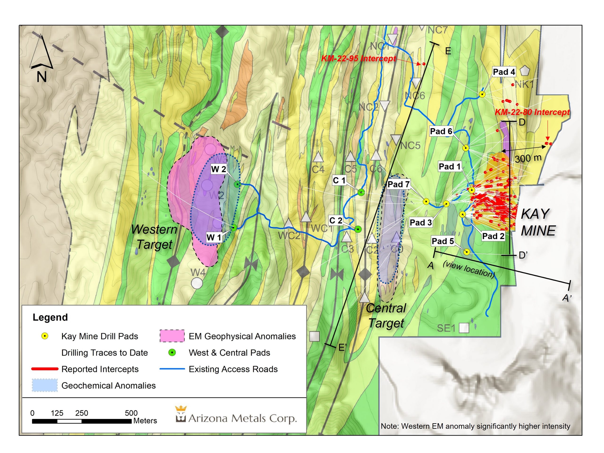
Arizona Metals (TSX:AMC) has announced new discoveries of copper-gold-zinc VMS mineralization in its Kay Mine Deposit in Arizona. The company’s step-out exploration drilling has intersected a potential new zone of mineralization located 600 m north and along strike of the Central Target EM anomaly. Hole KM-22-95 intersected 2.7 m grading 0.5% CuEq at a vertical depth of approximately 320 m. The discovery of clasts of massive sulphide mineralization in this interval is a positive indication of proximity to primary massive sulphide mineralization. Follow up drilling is planned to test for extensions of the mineralization encountered in this hole.
The company has also reported that extensional drilling at the northern edge of the Kay Mine Deposit has extended mineralization by 100 m north of hole KM-22-71A. Hole KM-23-97 intersected 8.8 m of 4.8% CuEq and confirmed the vertical continuity of high-grade mineralization in the 160 m between holes KM-20-11 and KM-21-19.
Arizona Metals has reported the results of six additional holes from the Kay Mine Deposit, including both infill and extensional holes.
The company commenced drilling at the Western Target in February 2023, with the first hole, KM-23-104, currently underway. The hole has been drilled to approximately 650 m west of pad W1 and to a vertical depth of 700 m below surface. After completion, a downhole electromagnetic survey will be conducted to test for extensions of conductors previously observed in both helicopter and ground-loop electromagnetic testing.
Arizona Metals is well-funded to complete its Phase 2 program at Kay Mine Deposit (budgeted at $1.6 million), with $53 million in cash as of Dec 31, 2022. The company plans to conduct an additional 76,000 meters of drilling in its Phase 3 program (budgeted at $32 million) to test numerous parallel targets heading west of the Kay Mine Deposit, as well as possible northern and southern extensions.
Marc Pais, CEO of Arizona Metals, commented in a press release: “The drill results reported today continue to demonstrate the expansion potential of the Kay Mine Deposit itself, and that it has the potential to be part of a much larger mineralized system. In January, we announced that VMS mineralization had been intersected approximately 300 metres north of the Kay Mine Deposit. At the Central Target, located 500 metres west of the Kay Mine Deposit, all the holes that have intersected the electromagnetic anomaly have encountered anomalous zinc and graphite mineralization.
We believe this style of mineralization is consistent with mineralization distal to a primary volcanic hydrothermal vent zone. Support for this model has come from hole KM-23-105, which intersected 2.7 m at 0.5% CuEq, 600 metres north of the Central EM anomaly and 400 metres west of the Kay Mine Deposit (see Fig 2). The presence of this mineralization demonstrates increasing proximity to a hydrothermal vent zone. We view the 600 metres between the Central Target EM anomaly and hole KM-23-105 as highly prospective for massive sulphide mineralization and are planning a number of drill holes to test this area. We are also pleased to report that drilling of the first hole at the Western Target is currently underway and we are now targeting the second hole in this area. Downhole electromagnetic surveying of the first hole is expected to commence shortly”.
Highlights from the results are as follows:
Recent drilling at the Kay Mine Deposit has focused mainly on step-out holes to probe the extent of mineralization.
Hole KM-22-97
- 8.8 m @ 4.8% CuEq and 1.5 m @ 1.3% CuEq
- Along the north edge about mid-way down the deposit, this hole extended mineralization ~100 m north of hole KM-22-71A and confirmed the vertical continuity of high-grade mineralization in the 160 m between holes KM-20-11 and KM-21-19.
Hole KM-22-98
- Three intervals, including 4.6 m @ 0.8% CuEq and 4.3 m @ 0.9% CuEq
- Drilled from pad 1 into the central upper part of the deposit, extending mineralization about 65 m upward into the gap between the upper North and upper South zones.
Hole KM-22-99
- 9.6 m @ 0.6% CuEq and 3.0 m @ 0.9% CuEq
- A step-out hole along the north edge of the deposit. Together with hole KM-22-97, extends mineralization about 160 m north of hole KM-22-71A in the upper middle portion of the deposit.
Hole KM-22-63B
- 1.5 m @ 0.5% Cu Eq
- Deep in the deposit, north of KM-22-63D
Hole KM-22-94
- Three intercepts: 17.7 m @ 0.7% CuEq, 3.2 m @ 1.1% CuEq, and 1.3 m @ 0.8% CuEq.
- This is a step-out hole deep in the deposit along the north edge, 33 m north of hole KM-21-27 and 55 m north of hole KM-22-57B.
Hole KM-22-94A
- Several intercepts, including 10.4 m @ 1.2% CuEq, and 3.4 m @ 2.1% CuEq.
- This hole wedged about 60 m below KM-22-94 and proved continuity between that hole and hole KM-21-51B.
Kay North Extension
Hole KM-22-80
- Two intervals: 5.6 m @ 0.9% CuEq, 3.0 m @ 0.5% CuEq
- Drilled from pad 6 to the east, north of the main Kay Mine Deposit. These intercepts are deep within the footwall of the deposit and are the easternmost intercepts. This suggests either potential for other deeper horizons or possible complex folding.
Hole KM-22-91
- 1.8 m @ 1.1% CuEq
- Drilled from pad 6 to the east. Extends mineralization about 150 m north of KM-22-87, which is located along the northern edge of drilled mineralization.
Central Target
Hole KM-22-95
- 2.7 m @ 0.5% CuEq from 432.8 m downhole. This is a mineralized intercept in a new area: 600 m along strike north from the north end of the Central EM anomaly, and 500 m west of the other drill intercepts in the pad 4 area.
- Drilled northwest from pad 4, to test a strong soil anomaly
- The mineralization is relatively Zn-rich (0.22% Cu, 0.12 g/t Au, 0.61% Zn) and is clearly distal. It lies about 10 m to 20 m downhole of and stratigraphically below the mafic-felsic contact on the east limb of the Central anticline.
- This interval shows mineralization along the prospective horizon far from any other known mineralization.
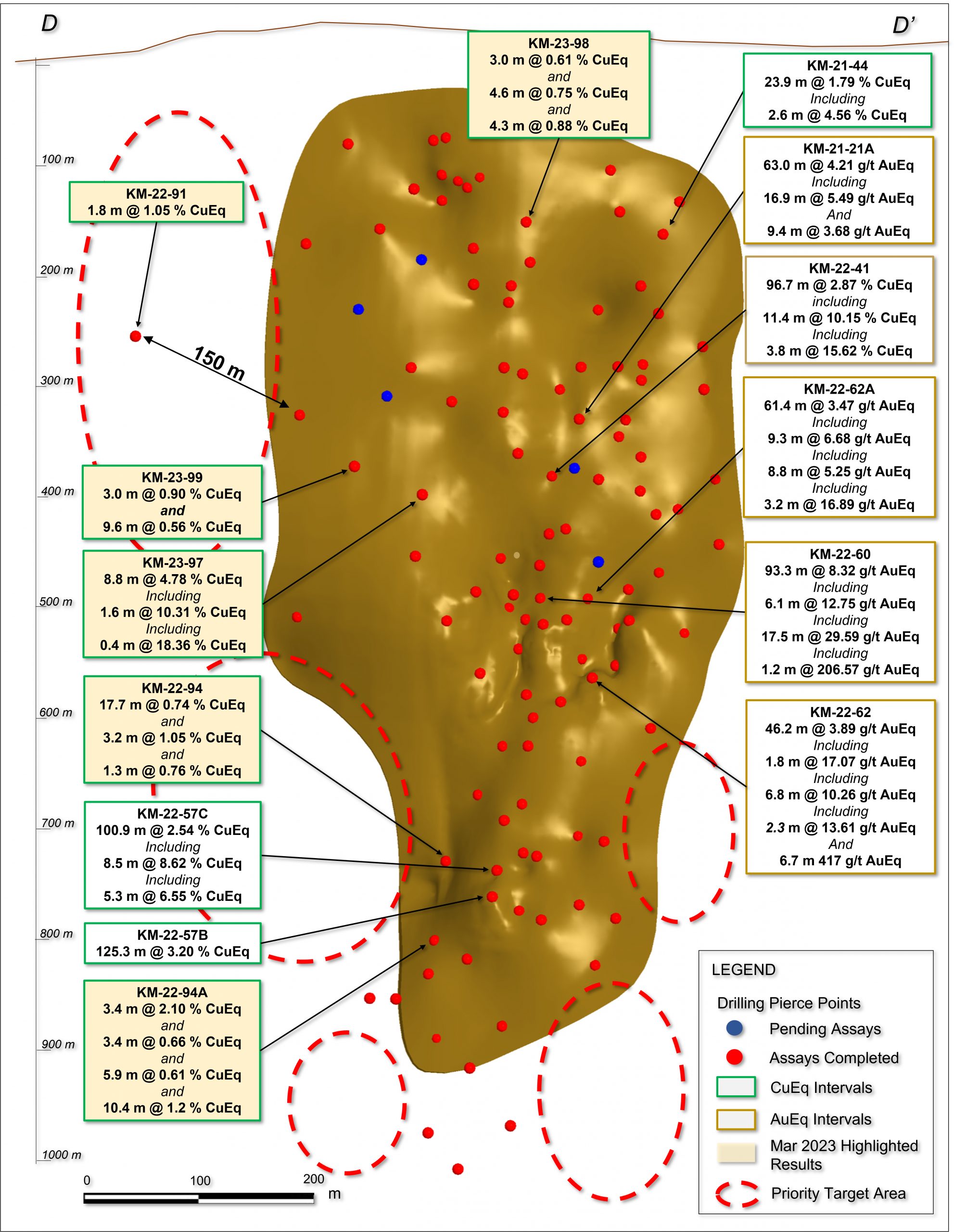
Kay Mine Project Phase 2 Drill Program Update
With the assayed holes released today, the Company has completed a total of 79,600 meters at the Kay Mine Project since inception of drilling. The Company is fully-funded to complete the remaining 3,800 meters planned for the Phase 2 program with the priority focus areas for upcoming drilling (shown in Figure 1 above) as well as an additional 76,000 meters currently planned for the upcoming Phase 3 program.
Table 1. Results of Phase 2 Drill Program at the Kay Mine Project, Yavapai County, Arizona announced in this news release.
| Analyzed Grade | Analyzed Metal Equivalent | Metal Equivalent | ||||||||||||
| Hole ID | From m | To m | Length m | Cu % | Au g/t | Zn % | Ag g/t | Pb % | Cu eq % | Au eq g/t | Zn eq% | Cu eq % | Au eq g/t | Zn eq% |
| KM-22-63A | no significant assays | |||||||||||||
| KM-22-63B |
890.3 |
891.8 |
1.5 |
0.10 |
0.47 |
0.43 |
15.0 |
0.08 |
0.68 |
1.12 |
1.77 |
0.54 |
0.89 |
1.41 |
| KM-22-63C | no significant assays | |||||||||||||
| KM-22-63D | no significant assays | |||||||||||||
| KM-22-78 | no significant assays | |||||||||||||
| KM-22-80 |
672.8 |
678.5 |
5.6 |
0.35 |
0.59 |
0.68 |
4.9 |
0.02 |
1.02 |
1.67 |
2.65 |
0.85 |
1.40 |
2.22 |
| KM-22-80 |
702.9 |
705.9 |
3.0 |
0.13 |
0.04 |
0.99 |
1.0 |
0.01 |
0.54 |
0.89 |
1.41 |
0.49 |
0.81 |
1.28 |
| KM-22-85 | no significant assays | |||||||||||||
| KM-22-90 | no significant assays | |||||||||||||
| KM-22-91 |
399.3 |
401.1 |
1.8 |
0.72 |
0.66 |
0.20 |
3.5 |
0.02 |
1.23 |
2.02 |
3.21 |
1.05 |
1.72 |
2.73 |
| KM-22-92 | no significant assays | |||||||||||||
| KM-22-94 |
797.4 |
815.0 |
17.7 |
0.73 |
0.04 |
0.06 |
3.1 |
0.01 |
0.81 |
1.33 |
2.11 |
0.74 |
1.22 |
1.93 |
| including |
797.4 |
798.7 |
1.4 |
1.43 |
0.03 |
0.02 |
3.7 |
0.02 |
1.49 |
2.44 |
3.87 |
1.37 |
2.25 |
3.58 |
| KM-22-94 |
829.4 |
832.6 |
3.2 |
0.54 |
0.75 |
0.48 |
6.9 |
0.06 |
1.25 |
2.05 |
3.26 |
1.05 |
1.71 |
2.72 |
| KM-22-94 |
854.5 |
855.8 |
1.3 |
0.76 |
0.09 |
0.02 |
2.0 |
0.00 |
0.84 |
1.37 |
2.18 |
0.76 |
1.25 |
1.99 |
| KM-22-94A |
829.1 |
832.4 |
3.4 |
2.18 |
0.03 |
0.07 |
5.2 |
0.05 |
2.27 |
3.73 |
5.91 |
2.10 |
3.44 |
5.47 |
| including |
829.1 |
829.7 |
0.6 |
9.43 |
0.10 |
0.27 |
22.0 |
0.23 |
9.82 |
16.09 |
25.54 |
9.08 |
14.88 |
23.61 |
| KM-22-94A |
850.1 |
853.4 |
3.4 |
0.63 |
0.11 |
0.02 |
2.4 |
0.02 |
0.73 |
1.20 |
1.90 |
0.66 |
1.08 |
1.71 |
| KM-22-94A |
858.9 |
864.9 |
5.9 |
0.62 |
0.02 |
0.02 |
2.3 |
0.01 |
0.67 |
1.09 |
1.74 |
0.61 |
1.01 |
1.60 |
| KM-22-94A |
871.9 |
882.2 |
10.4 |
1.21 |
0.09 |
0.05 |
3.6 |
0.01 |
1.31 |
2.15 |
3.42 |
1.20 |
1.97 |
3.13 |
| KM-22-95 |
432.8 |
435.6 |
2.7 |
0.22 |
0.12 |
0.61 |
4.1 |
0.02 |
0.57 |
0.94 |
1.48 |
0.50 |
0.83 |
1.31 |
| KM-22-96 | no significant assays | |||||||||||||
| KM-23-97 |
512.2 |
521.0 |
8.8 |
2.87 |
2.24 |
2.65 |
27.7 |
0.31 |
5.54 |
9.08 |
14.41 |
4.78 |
7.83 |
12.43 |
| including |
516.1 |
517.7 |
1.6 |
8.12 |
3.67 |
2.33 |
61.2 |
0.14 |
11.76 |
19.28 |
30.60 |
10.31 |
16.91 |
26.83 |
| including |
516.8 |
517.2 |
0.4 |
17.10 |
4.59 |
0.40 |
59.0 |
0.08 |
20.54 |
33.67 |
53.43 |
18.36 |
30.09 |
47.75 |
| KM-23-97 |
595.3 |
596.8 |
1.5 |
0.95 |
0.80 |
0.03 |
9.0 |
0.01 |
1.52 |
2.50 |
3.97 |
1.29 |
2.11 |
3.36 |
| KM-23-98 |
255.7 |
258.8 |
3.0 |
0.53 |
0.13 |
0.11 |
3.5 |
0.01 |
0.69 |
1.12 |
1.78 |
0.61 |
1.00 |
1.59 |
| KM-23-98 |
312.4 |
317.0 |
4.6 |
0.70 |
0.06 |
0.13 |
4.1 |
0.02 |
0.82 |
1.35 |
2.14 |
0.75 |
1.23 |
1.95 |
| KM-23-98 |
342.9 |
347.2 |
4.3 |
0.75 |
0.33 |
0.06 |
3.3 |
0.00 |
1.00 |
1.64 |
2.60 |
0.88 |
1.44 |
2.28 |
| KM-23-99 |
459.8 |
462.8 |
3.0 |
0.61 |
0.28 |
0.44 |
7.0 |
0.09 |
1.02 |
1.67 |
2.65 |
0.90 |
1.47 |
2.33 |
| KM-23-99 |
508.3 |
517.9 |
9.6 |
0.04 |
0.59 |
0.74 |
2.0 |
0.03 |
0.70 |
1.15 |
1.82 |
0.56 |
0.92 |
1.47 |
The true width of mineralization is estimated to be 50% to 99% of reported core width, with an average of 76%. (2) Assumptions used in USD for the copper and gold metal equivalent calculations were metal prices of $4.63/lb Copper, $1937/oz Gold, $25/oz Silver, $1.78/lb Zinc, and $1.02/lb Pb. Assumed metal recoveries (rec.), based on a preliminary review of historic data by SRK and ProcessIQ1, were 93% for copper, 92% for zinc, 90% for lead, 72% silver, and 70% for gold. The following equation was used to calculate copper equivalence: CuEq = Copper (%) (93% rec.) + (Gold (g/t) x 0.61)(72% rec.) + (Silver (g/t) x 0.0079)(72% rec.) + (Zinc (%) x 0.3844)(93% rec.) +(Lead (%) x 0.2203)(93% rec.). The following equation was used to calculate gold equivalence: AuEq = Gold (g/t)(72% rec.) + (Copper (%) x 1.638)(93% rec.) + (Silver (g/t) x 0.01291)(72% rec.) + (Zinc (%) x 0.6299)(93% rec.) +(Lead (%) x 0.3609)(93% rec.). Analyzed metal equivalent calculations are reported for illustrative purposes only. The metal chosen for reporting on an equivalent basis is the one that contributes the most dollar value after accounting for assumed recoveries.
Table 2. Full results of Phase 2 Drill Program at the Kay Mine Deposit, Yavapai County, Arizona.
| Analyzed Grade | Analyzed Metal Equivalent | Metal Equivalent | ||||||||||||
| Hole ID | From m | To m | Length m | Cu % | Au g/t | Zn % | Ag g/t | Pb % | Cu eq % | Au eq g/t | Zn eq% | Cu eq % | Au eq g/t | Zn eq% |
| KM-21-17 |
429.5 |
449.9 |
20.4 |
1.81 |
1.10 |
1.20 |
21.2 |
0.17 |
3.14 |
5.15 |
8.18 |
2.73 |
4.47 |
7.10 |
| including |
429.5 |
434.0 |
4.6 |
4.61 |
1.73 |
1.91 |
29.1 |
0.24 |
6.68 |
10.96 |
17.39 |
5.92 |
9.70 |
15.39 |
| including |
432.7 |
434.0 |
1.4 |
0.52 |
6.81 |
8.29 |
40.0 |
1.10 |
8.41 |
13.79 |
21.89 |
6.76 |
11.09 |
17.60 |
| KM-21-17 |
504.4 |
505.4 |
0.9 |
1.19 |
4.73 |
0.05 |
9.0 |
0.00 |
4.17 |
6.83 |
10.84 |
3.20 |
5.24 |
8.31 |
| KM-21-18 |
404.3 |
429.8 |
25.5 |
0.35 |
0.86 |
1.71 |
15.8 |
0.23 |
1.71 |
2.80 |
4.44 |
1.43 |
2.35 |
3.72 |
| including |
408.6 |
410.6 |
2.0 |
0.50 |
2.22 |
7.25 |
64.4 |
0.82 |
5.33 |
8.74 |
13.87 |
4.51 |
7.39 |
11.72 |
| including |
424.9 |
427.3 |
2.4 |
1.60 |
2.59 |
3.16 |
18.0 |
0.52 |
4.66 |
7.64 |
12.12 |
3.92 |
6.43 |
10.21 |
| KM-21-18A |
391.4 |
423.8 |
32.5 |
1.09 |
0.62 |
1.25 |
17.7 |
0.15 |
2.13 |
3.48 |
5.53 |
1.85 |
3.04 |
4.82 |
| including |
393.3 |
395.8 |
2.4 |
9.57 |
2.83 |
2.72 |
40.9 |
0.28 |
12.73 |
20.87 |
33.12 |
11.36 |
18.63 |
29.56 |
| KM-21-19 |
377.8 |
378.3 |
0.5 |
3.39 |
5.59 |
6.83 |
128.0 |
0.63 |
10.58 |
17.34 |
27.52 |
8.81 |
14.44 |
22.92 |
| KM-21-20 |
442.7 |
443.6 |
0.9 |
2.56 |
0.52 |
3.52 |
18.5 |
0.14 |
4.40 |
7.22 |
11.45 |
3.98 |
6.52 |
10.34 |
| KM-21-20 |
456.0 |
458.1 |
2.1 |
1.49 |
0.35 |
0.14 |
6.0 |
0.04 |
1.81 |
2.97 |
4.71 |
1.63 |
2.66 |
4.23 |
| KM-21-21 |
452.6 |
495.5 |
42.8 |
0.80 |
0.78 |
1.52 |
15.1 |
0.15 |
2.01 |
3.29 |
5.22 |
1.73 |
2.83 |
4.49 |
| including |
488.7 |
493.5 |
4.8 |
0.26 |
2.50 |
6.13 |
27.6 |
0.54 |
4.48 |
7.34 |
11.65 |
3.74 |
6.13 |
9.73 |
| KM-21-21A |
422.0 |
431.4 |
9.4 |
1.17 |
0.57 |
2.25 |
8.6 |
0.36 |
2.53 |
4.15 |
6.58 |
2.25 |
3.68 |
5.85 |
| KM-21-21A |
439.1 |
502.1 |
63.0 |
0.45 |
1.28 |
3.14 |
58.8 |
0.77 |
3.08 |
5.04 |
8.00 |
2.57 |
4.21 |
6.67 |
| including |
465.0 |
481.9 |
16.9 |
0.52 |
2.45 |
4.05 |
80.9 |
0.99 |
4.43 |
7.26 |
11.53 |
3.62 |
5.94 |
9.42 |
| KM-21-22 |
679.4 |
682.8 |
3.4 |
0.79 |
0.95 |
0.06 |
12.0 |
0.01 |
1.49 |
2.44 |
3.87 |
1.23 |
2.01 |
3.20 |
| KM-21-23 |
394.4 |
401.4 |
7.0 |
0.36 |
0.93 |
1.94 |
13.5 |
1.17 |
2.05 |
3.35 |
5.32 |
1.73 |
2.84 |
4.51 |
| KM-21-23 |
438.6 |
459.2 |
20.6 |
0.17 |
1.18 |
1.93 |
27.8 |
0.37 |
1.94 |
3.17 |
5.03 |
1.58 |
2.59 |
4.11 |
| KM-21-24 |
501.2 |
592.1 |
90.8 |
0.45 |
1.33 |
3.42 |
44.6 |
0.41 |
3.02 |
4.95 |
7.86 |
2.53 |
4.15 |
6.59 |
| including |
501.2 |
521.7 |
20.4 |
1.34 |
1.70 |
6.35 |
113.1 |
0.66 |
5.86 |
9.60 |
15.24 |
4.99 |
8.18 |
12.99 |
| including |
520.9 |
521.7 |
0.8 |
1.75 |
16.50 |
9.55 |
574.0 |
1.22 |
20.31 |
33.29 |
52.82 |
15.57 |
25.52 |
40.50 |
| including |
575.9 |
592.1 |
16.2 |
0.16 |
2.50 |
6.00 |
44.4 |
0.79 |
4.51 |
7.40 |
11.74 |
3.75 |
6.14 |
9.74 |
| including |
588.7 |
590.4 |
1.7 |
0.47 |
9.98 |
23.70 |
18.2 |
0.13 |
15.84 |
25.96 |
41.20 |
13.21 |
21.65 |
34.36 |
| KM-21-25 |
662.6 |
741.3 |
78.6 |
1.41 |
2.33 |
2.79 |
43.4 |
0.35 |
4.33 |
7.10 |
11.26 |
3.61 |
5.92 |
9.40 |
| including |
663.2 |
672.7 |
9.4 |
8.06 |
1.84 |
1.31 |
92.3 |
0.15 |
10.45 |
17.13 |
27.18 |
9.30 |
15.24 |
24.19 |
| including |
693.0 |
703.9 |
11.0 |
0.68 |
6.28 |
10.40 |
99.7 |
1.17 |
9.56 |
15.66 |
24.86 |
7.79 |
12.77 |
20.27 |
| KM-21-25A |
654.7 |
719.9 |
65.2 |
1.04 |
1.94 |
2.15 |
18.9 |
0.18 |
3.25 |
5.32 |
8.44 |
2.71 |
4.43 |
7.04 |
| including |
655.5 |
662.8 |
7.3 |
3.66 |
2.09 |
1.85 |
30.2 |
0.21 |
5.93 |
9.73 |
15.44 |
5.17 |
8.47 |
13.44 |
| including |
710.8 |
716.9 |
6.1 |
2.72 |
7.95 |
3.73 |
37.4 |
0.31 |
9.37 |
15.36 |
24.38 |
7.52 |
12.33 |
19.56 |
| KM-21-25B |
647.2 |
648.9 |
1.7 |
0.13 |
0.58 |
2.41 |
62.1 |
0.64 |
2.04 |
3.35 |
5.31 |
1.70 |
2.79 |
4.42 |
| KM-21-25B |
655.6 |
659.9 |
4.3 |
0.93 |
0.91 |
0.91 |
25.3 |
0.19 |
2.07 |
3.40 |
5.40 |
1.75 |
2.88 |
4.56 |
| KM-21-25B |
666.0 |
667.8 |
1.8 |
0.60 |
0.72 |
2.98 |
33.5 |
0.43 |
2.55 |
4.18 |
6.63 |
2.20 |
3.61 |
5.72 |
| KM-21-25B |
673.3 |
674.7 |
1.4 |
0.08 |
2.10 |
2.39 |
23.0 |
0.33 |
2.53 |
4.15 |
6.58 |
2.01 |
3.29 |
5.23 |
| KM-21-25B |
681.2 |
682.6 |
1.4 |
0.09 |
1.54 |
2.98 |
11.0 |
0.35 |
2.34 |
3.83 |
6.08 |
1.93 |
3.16 |
5.01 |
| KM-21-26 |
506.7 |
582.8 |
76.0 |
0.79 |
1.61 |
4.23 |
32.7 |
0.54 |
3.78 |
6.19 |
9.83 |
3.21 |
5.27 |
8.36 |
| including |
511.1 |
526.1 |
14.9 |
0.73 |
1.78 |
9.68 |
43.3 |
0.77 |
6.05 |
9.92 |
15.74 |
5.26 |
8.63 |
13.69 |
| including |
573.8 |
582.8 |
9.0 |
4.02 |
6.06 |
3.32 |
18.2 |
0.19 |
9.18 |
15.04 |
23.87 |
7.64 |
12.52 |
19.87 |
| KM-21-27 |
706.8 |
738.2 |
31.4 |
1.58 |
0.16 |
0.69 |
9.0 |
0.06 |
2.03 |
3.33 |
5.28 |
1.85 |
3.03 |
4.80 |
| KM-21-27 |
764.4 |
777.4 |
13.0 |
2.85 |
0.48 |
0.17 |
8.5 |
0.02 |
3.29 |
5.39 |
8.55 |
2.97 |
4.87 |
7.73 |
| KM-21-27A |
666.3 |
769.4 |
103.1 |
0.79 |
1.06 |
1.90 |
35.8 |
0.42 |
2.54 |
4.17 |
6.62 |
2.15 |
3.52 |
5.59 |
| including |
666.3 |
687.0 |
20.7 |
3.21 |
1.39 |
1.26 |
19.4 |
0.20 |
4.74 |
7.77 |
12.33 |
4.18 |
6.84 |
10.86 |
| including |
706.4 |
724.6 |
18.3 |
0.69 |
2.69 |
4.70 |
92.2 |
1.21 |
5.13 |
8.41 |
13.35 |
4.22 |
6.91 |
10.97 |
| including |
752.9 |
763.8 |
11.0 |
0.07 |
1.07 |
4.68 |
95.3 |
0.98 |
3.49 |
5.73 |
9.09 |
2.92 |
4.78 |
7.59 |
| KM-21-27B |
665.8 |
762.9 |
97.1 |
1.31 |
1.62 |
3.21 |
31.7 |
0.40 |
3.88 |
6.35 |
10.08 |
3.31 |
5.42 |
8.61 |
| including |
702.0 |
723.0 |
21.0 |
0.87 |
4.56 |
9.03 |
81.5 |
1.10 |
8.01 |
13.13 |
20.83 |
6.63 |
10.87 |
17.25 |
| including |
723.0 |
738.2 |
15.2 |
4.97 |
0.36 |
0.42 |
18.7 |
0.05 |
5.51 |
9.03 |
14.33 |
5.04 |
8.26 |
13.11 |
| KM-21-28 |
640.7 |
694.9 |
54.3 |
1.87 |
2.85 |
5.03 |
29.4 |
0.70 |
5.93 |
9.72 |
15.43 |
5.04 |
8.26 |
13.12 |
| including |
660.2 |
671.6 |
11.4 |
0.54 |
4.29 |
9.30 |
32.2 |
1.17 |
7.24 |
11.87 |
18.84 |
6.04 |
9.89 |
15.70 |
| including |
681.1 |
689.0 |
7.9 |
4.39 |
9.47 |
10.34 |
93.1 |
2.41 |
15.42 |
25.27 |
40.10 |
12.80 |
20.98 |
33.29 |
| including |
690.4 |
692.6 |
2.2 |
16.06 |
0.82 |
0.06 |
55.8 |
0.01 |
17.02 |
27.90 |
44.28 |
15.62 |
25.61 |
40.64 |
| KM-21-29 |
393.0 |
393.8 |
0.8 |
0.43 |
1.54 |
4.92 |
9.0 |
0.21 |
3.38 |
5.54 |
8.79 |
2.89 |
4.74 |
7.53 |
| KM-21-30 |
264.9 |
267.9 |
3.0 |
1.18 |
0.02 |
0.01 |
1.5 |
0.00 |
1.21 |
1.98 |
3.15 |
1.12 |
1.83 |
2.91 |
| KM-21-32 |
316.4 |
320.0 |
3.7 |
1.84 |
1.29 |
2.47 |
38.5 |
0.30 |
3.95 |
6.47 |
10.27 |
3.41 |
5.60 |
8.88 |
| KM-21-32 |
342.9 |
345.9 |
3.0 |
0.67 |
0.52 |
2.70 |
13.0 |
0.15 |
2.16 |
3.54 |
5.62 |
1.90 |
3.12 |
4.95 |
| KM-21-32 |
358.9 |
368.4 |
9.4 |
0.60 |
1.47 |
1.99 |
45.7 |
0.35 |
2.70 |
4.42 |
7.01 |
2.22 |
3.63 |
5.76 |
| KM-21-33 |
171.3 |
172.5 |
1.2 |
3.79 |
0.45 |
0.21 |
63.0 |
0.17 |
4.69 |
7.68 |
12.19 |
4.19 |
6.86 |
10.89 |
| KM-21-34 |
299.3 |
303.9 |
4.6 |
0.29 |
1.69 |
0.94 |
46.3 |
0.26 |
2.12 |
3.47 |
5.50 |
1.65 |
2.70 |
4.29 |
| KM-21-34 |
309.7 |
310.9 |
1.2 |
2.27 |
0.56 |
1.55 |
19.9 |
0.08 |
3.38 |
5.54 |
8.80 |
3.03 |
4.96 |
7.87 |
| KM-21-35 |
609.6 |
615.1 |
5.5 |
0.92 |
1.26 |
1.71 |
57.7 |
0.02 |
2.80 |
4.60 |
7.29 |
2.33 |
3.82 |
6.06 |
| including |
609.6 |
613.0 |
3.4 |
1.39 |
1.69 |
1.98 |
54.0 |
0.01 |
3.61 |
5.92 |
9.40 |
3.03 |
4.96 |
7.87 |
| KM-21-38 |
406.5 |
407.8 |
1.4 |
0.60 |
1.08 |
9.41 |
4.0 |
0.25 |
4.96 |
8.13 |
12.90 |
4.42 |
7.24 |
11.49 |
| KM-21-38 |
467.4 |
476.1 |
8.7 |
0.09 |
1.73 |
3.87 |
61.1 |
1.22 |
3.38 |
5.55 |
8.80 |
2.78 |
4.56 |
7.23 |
| including |
470.0 |
475.2 |
5.2 |
0.12 |
2.44 |
5.68 |
87.5 |
1.79 |
4.88 |
8.01 |
12.71 |
4.02 |
6.59 |
10.46 |
| KM-21-40 |
589.8 |
613.8 |
24.0 |
4.98 |
0.61 |
0.98 |
23.4 |
0.45 |
6.01 |
9.86 |
15.65 |
5.46 |
8.95 |
14.21 |
| including |
589.8 |
597.9 |
8.1 |
7.63 |
0.43 |
0.39 |
27.1 |
0.17 |
8.30 |
13.60 |
21.58 |
7.61 |
12.47 |
19.78 |
| KM-21-40 |
627.9 |
680.8 |
52.9 |
0.47 |
2.91 |
3.40 |
35.7 |
0.40 |
3.93 |
6.44 |
10.22 |
3.17 |
5.20 |
8.25 |
| including |
641.1 |
648.3 |
7.2 |
1.15 |
7.66 |
8.27 |
88.5 |
0.92 |
9.90 |
16.23 |
25.76 |
7.95 |
13.03 |
20.68 |
| including |
670.3 |
674.1 |
3.8 |
1.53 |
10.89 |
9.47 |
24.6 |
0.61 |
12.15 |
19.91 |
31.59 |
9.69 |
15.88 |
25.19 |
| KM-21-41 |
462.6 |
559.3 |
96.7 |
1.04 |
1.54 |
2.66 |
40.8 |
0.35 |
3.41 |
5.59 |
8.86 |
2.87 |
4.71 |
7.47 |
| including |
503.2 |
514.2 |
11.0 |
0.99 |
5.34 |
8.17 |
106.3 |
1.63 |
8.59 |
14.08 |
22.35 |
7.02 |
11.51 |
18.26 |
| including |
546.7 |
558.1 |
11.4 |
5.86 |
5.83 |
3.24 |
185.4 |
0.04 |
12.14 |
19.90 |
31.58 |
10.15 |
16.64 |
26.40 |
| including |
553.1 |
556.9 |
3.8 |
7.11 |
9.55 |
5.70 |
505.8 |
0.09 |
19.16 |
31.41 |
49.84 |
15.62 |
25.59 |
40.62 |
| KM-21-42 |
803.5 |
810.3 |
6.9 |
0.05 |
1.60 |
1.58 |
64.3 |
0.35 |
2.22 |
3.64 |
5.78 |
1.73 |
2.83 |
4.49 |
| KM-21-42 |
835.5 |
839.7 |
4.3 |
0.63 |
2.46 |
2.15 |
21.7 |
0.21 |
3.18 |
5.20 |
8.26 |
2.56 |
4.20 |
6.67 |
| KM-21-42 |
853.7 |
854.7 |
0.9 |
0.11 |
1.63 |
2.88 |
28.0 |
0.40 |
2.52 |
4.13 |
6.55 |
2.05 |
3.37 |
5.34 |
| KM-21-42A |
786.7 |
787.6 |
0.9 |
0.03 |
3.61 |
2.18 |
17.0 |
0.70 |
3.36 |
5.51 |
8.74 |
2.58 |
4.22 |
6.70 |
| KM-21-42A |
805.4 |
811.1 |
5.6 |
6.17 |
0.92 |
0.18 |
39.5 |
0.01 |
7.12 |
11.68 |
18.53 |
6.43 |
10.54 |
16.72 |
| including |
807.0 |
808.9 |
2.0 |
10.72 |
0.87 |
0.11 |
61.8 |
0.00 |
11.79 |
19.32 |
30.66 |
10.74 |
17.60 |
27.93 |
| KM-21-42A |
840.9 |
877.2 |
36.3 |
0.55 |
0.62 |
1.35 |
10.7 |
0.13 |
1.56 |
2.56 |
4.06 |
1.34 |
2.20 |
3.49 |
| KM-21-42B |
808.0 |
811.2 |
3.2 |
0.29 |
2.06 |
5.77 |
63.0 |
0.94 |
4.47 |
7.33 |
11.63 |
3.74 |
6.13 |
9.72 |
| KM-21-42B |
816.9 |
819.9 |
3.0 |
2.31 |
0.66 |
1.23 |
16.0 |
0.15 |
3.35 |
5.49 |
8.71 |
2.99 |
4.90 |
7.77 |
| KM-21-42B |
835.5 |
840.8 |
5.3 |
0.02 |
0.73 |
2.93 |
13.5 |
0.24 |
1.75 |
2.87 |
4.56 |
1.49 |
2.45 |
3.88 |
| KM-21-42C |
849.2 |
877.4 |
28.2 |
3.81 |
0.47 |
0.29 |
12.5 |
0.09 |
4.32 |
7.08 |
11.24 |
3.93 |
6.44 |
10.23 |
| including |
849.2 |
854.7 |
5.5 |
14.57 |
0.66 |
0.16 |
37.5 |
0.03 |
15.34 |
25.14 |
39.89 |
14.11 |
23.12 |
36.70 |
| including |
863.8 |
869.4 |
5.6 |
2.29 |
1.17 |
0.59 |
13.1 |
0.25 |
3.39 |
5.55 |
8.81 |
2.96 |
4.85 |
7.70 |
| including |
874.8 |
877.4 |
2.6 |
2.83 |
0.26 |
0.03 |
7.2 |
0.01 |
3.06 |
5.02 |
7.96 |
2.80 |
4.59 |
7.28 |
| KM-21-42C |
886.1 |
889.1 |
3.0 |
0.87 |
0.88 |
0.50 |
5.2 |
0.05 |
1.65 |
2.71 |
4.30 |
1.40 |
2.30 |
3.65 |
| KM-21-43 |
583.7 |
607.1 |
23.4 |
0.39 |
0.25 |
3.68 |
3.1 |
0.02 |
1.98 |
3.25 |
5.15 |
1.79 |
2.93 |
4.65 |
| including |
598.9 |
599.8 |
0.9 |
0.50 |
0.18 |
11.30 |
3.0 |
0.03 |
4.99 |
8.17 |
12.97 |
4.56 |
7.48 |
11.87 |
| KM-21-43 |
616.0 |
633.1 |
17.1 |
1.81 |
0.17 |
0.14 |
8.2 |
0.03 |
2.04 |
3.34 |
5.31 |
1.86 |
3.05 |
4.84 |
| including |
631.2 |
633.1 |
1.8 |
6.30 |
0.61 |
0.09 |
25.0 |
0.01 |
6.91 |
11.32 |
17.97 |
6.30 |
10.32 |
16.38 |
| KM-21-44 |
353.4 |
377.3 |
23.9 |
0.34 |
0.97 |
2.52 |
18.3 |
0.33 |
2.12 |
3.47 |
5.50 |
1.79 |
2.93 |
4.65 |
| including |
354.0 |
356.6 |
2.6 |
0.23 |
2.14 |
7.97 |
38.9 |
0.68 |
5.06 |
8.29 |
13.15 |
4.30 |
7.05 |
11.19 |
| KM-21-45 |
459.6 |
463.0 |
3.4 |
0.32 |
0.62 |
6.63 |
82.3 |
0.87 |
4.10 |
6.71 |
10.65 |
3.55 |
5.82 |
9.24 |
| including |
461.2 |
462.1 |
0.9 |
0.15 |
1.23 |
16.90 |
182.0 |
2.50 |
9.39 |
15.38 |
24.41 |
8.17 |
13.39 |
21.26 |
| KM-21-46 |
350.4 |
362.9 |
12.4 |
0.66 |
2.61 |
3.69 |
40.6 |
0.39 |
4.08 |
6.69 |
10.61 |
3.34 |
5.48 |
8.70 |
| including |
350.4 |
353.3 |
2.8 |
0.77 |
5.19 |
6.83 |
107.0 |
0.72 |
7.58 |
12.42 |
19.70 |
6.11 |
10.01 |
15.88 |
| KM-21-47 |
433.9 |
435.9 |
2.0 |
0.16 |
1.88 |
9.28 |
138.7 |
2.17 |
6.46 |
10.58 |
16.79 |
5.46 |
8.95 |
14.20 |
| KM-21-48 |
605.2 |
610.7 |
5.5 |
3.54 |
0.45 |
0.19 |
12.7 |
0.05 |
4.00 |
6.55 |
10.40 |
3.63 |
5.95 |
9.45 |
| KM-21-48 |
630.3 |
634.6 |
4.3 |
1.11 |
0.34 |
0.69 |
12.7 |
0.11 |
1.71 |
2.80 |
4.45 |
1.52 |
2.49 |
3.95 |
| KM-21-48 |
685.5 |
696.8 |
11.3 |
0.98 |
0.05 |
0.06 |
4.2 |
0.02 |
1.07 |
1.75 |
2.77 |
0.98 |
1.60 |
2.54 |
| KM-21-48 |
715.1 |
718.4 |
3.4 |
2.08 |
0.04 |
0.03 |
4.3 |
0.01 |
2.15 |
3.52 |
5.59 |
1.98 |
3.25 |
5.16 |
| KM-21-48 |
723.0 |
724.5 |
1.5 |
1.54 |
0.07 |
0.06 |
4.0 |
0.02 |
1.64 |
2.68 |
4.26 |
1.51 |
2.47 |
3.92 |
| KM-21-48 |
735.5 |
743.6 |
8.1 |
0.34 |
0.60 |
1.52 |
9.2 |
0.07 |
1.38 |
2.26 |
3.59 |
1.18 |
1.93 |
3.06 |
| KM-21-48A |
538.0 |
539.5 |
1.5 |
0.31 |
1.17 |
2.79 |
29.0 |
0.52 |
2.44 |
4.01 |
6.36 |
2.05 |
3.35 |
5.32 |
| KM-21-48A |
687.9 |
696.9 |
9.0 |
1.64 |
0.36 |
0.79 |
7.9 |
0.01 |
2.23 |
3.66 |
5.80 |
2.01 |
3.29 |
5.22 |
| including |
687.9 |
688.8 |
0.9 |
0.15 |
1.53 |
5.35 |
5.0 |
0.01 |
3.18 |
5.21 |
8.27 |
2.71 |
4.45 |
7.06 |
| including |
694.9 |
696.0 |
1.1 |
8.36 |
0.80 |
0.10 |
40.0 |
0.03 |
9.21 |
15.10 |
23.96 |
8.39 |
13.75 |
21.81 |
| KM-21-49 | lost hole | |||||||||||||
The true width of mineralization is estimated to be 50% to 99% of reported core width, with an average of 76%. (2) Assumptions used in USD for the copper and gold metal equivalent calculations were metal prices of $4.63/lb Copper, $1937/oz Gold, $25/oz Silver, $1.78/lb Zinc, and $1.02/lb Pb. Assumed metal recoveries (rec.), based on a preliminary review of historic data by SRK and ProcessIQ2, were 93% for copper, 92% for zinc, 90% for lead, 72% silver, and 70% for gold. The following equation was used to calculate copper equivalence: CuEq = Copper (%) (93% rec.) + (Gold (g/t) x 0.61)(72% rec.) + (Silver (g/t) x 0.0079)(72% rec.) + (Zinc (%) x 0.3844)(93% rec.) +(Lead (%) x 0.2203)(93% rec.). The following equation was used to calculate gold equivalence: AuEq = Gold (g/t)(72% rec.) + (Copper (%) x 1.638)(93% rec.) + (Silver (g/t) x 0.01291)(72% rec.) + (Zinc (%) x 0.6299)(93% rec.) +(Lead (%) x 0.3609)(93% rec.). Analyzed metal equivalent calculations are reported for illustrative purposes only. The metal chosen for reporting on an equivalent basis is the one that contributes the most dollar value after accounting for assumed recoveries.
Table 3. Full results to date of Phase 2 Drill Program at the Kay Mine Deposit, Yavapai County, Arizona. See Table 2 for width and metal equivalency notes.
| Analyzed Grade | Analyzed Metal Equivalent | Metal Equivalent | ||||||||||||
| Hole ID | From m | To m | Length m | Cu % | Au g/t | Zn % | Ag g/t | Pb % | Cu eq % | Au eq g/t | Zn eq% | Cu eq % | Au eq g/t | Zn eq% |
| KM-21-50 |
489.5 |
501.9 |
12.3 |
0.98 |
2.30 |
6.36 |
111.9 |
1.24 |
5.99 |
9.81 |
15.57 |
5.02 |
8.24 |
13.07 |
| including |
489.5 |
493.0 |
3.4 |
2.64 |
3.59 |
9.49 |
207.7 |
1.65 |
10.49 |
17.20 |
27.30 |
8.86 |
14.52 |
23.05 |
| KM-21-50 |
509.0 |
562.1 |
53.1 |
0.44 |
0.84 |
1.28 |
35.8 |
0.27 |
1.79 |
2.93 |
4.65 |
1.48 |
2.42 |
3.84 |
| including |
538.1 |
545.6 |
7.5 |
0.28 |
1.94 |
2.62 |
112.8 |
0.82 |
3.55 |
5.81 |
9.23 |
2.82 |
4.63 |
7.34 |
| KM-21-51B |
860.5 |
870.2 |
9.8 |
3.00 |
0.13 |
0.10 |
6.5 |
0.05 |
3.18 |
5.21 |
8.27 |
2.93 |
4.80 |
7.62 |
| including |
864.7 |
865.6 |
0.9 |
8.70 |
0.09 |
0.09 |
16.0 |
0.10 |
8.93 |
14.64 |
23.24 |
8.27 |
13.55 |
21.51 |
| KM-21-51B |
881.5 |
884.2 |
2.7 |
0.52 |
0.22 |
0.62 |
28.3 |
0.14 |
1.15 |
1.88 |
2.98 |
0.99 |
1.61 |
2.56 |
| KM-21-51B |
893.7 |
903.4 |
9.8 |
1.51 |
0.10 |
0.06 |
4.4 |
0.01 |
1.63 |
2.67 |
4.24 |
1.49 |
2.45 |
3.89 |
| including |
898.2 |
899.3 |
1.1 |
6.56 |
0.11 |
0.10 |
15.0 |
0.04 |
6.79 |
11.13 |
17.67 |
6.28 |
10.29 |
16.32 |
| KM-21-52 |
751.5 |
758.2 |
6.7 |
1.18 |
0.66 |
0.98 |
18.2 |
0.14 |
2.14 |
3.50 |
5.56 |
1.86 |
3.05 |
4.84 |
| KM-21-52 |
787.5 |
789.6 |
2.1 |
0.04 |
1.27 |
1.68 |
28.5 |
0.22 |
1.73 |
2.84 |
4.50 |
1.38 |
2.25 |
3.58 |
| KM-21-52A |
763.7 |
793.1 |
29.4 |
0.25 |
1.12 |
1.36 |
51.6 |
0.47 |
1.97 |
3.22 |
5.11 |
1.58 |
2.58 |
4.10 |
| including |
763.7 |
764.9 |
1.2 |
0.38 |
3.01 |
8.69 |
132.0 |
1.68 |
6.97 |
11.43 |
18.13 |
5.80 |
9.50 |
15.08 |
| including |
771.8 |
774.5 |
2.7 |
1.39 |
2.46 |
4.59 |
116.4 |
1.82 |
5.98 |
9.81 |
15.56 |
5.00 |
8.19 |
12.99 |
| including |
781.5 |
787.6 |
6.1 |
0.31 |
2.63 |
1.64 |
119.5 |
0.65 |
3.64 |
5.97 |
9.47 |
2.81 |
4.60 |
7.30 |
| KM-21-52A |
801.3 |
802.5 |
1.2 |
0.42 |
0.90 |
1.29 |
82.0 |
0.17 |
2.15 |
3.52 |
5.59 |
1.73 |
2.83 |
4.50 |
| KM-21-52A |
818.8 |
820.2 |
1.4 |
0.39 |
1.62 |
1.29 |
188.0 |
0.36 |
3.45 |
5.65 |
8.96 |
2.66 |
4.35 |
6.91 |
| KM-21-52A |
831.2 |
852.4 |
21.2 |
0.05 |
0.91 |
0.80 |
27.2 |
0.29 |
1.19 |
1.95 |
3.10 |
0.93 |
1.52 |
2.42 |
| including |
837.0 |
841.6 |
4.6 |
0.03 |
2.16 |
1.34 |
69.0 |
0.79 |
2.59 |
4.24 |
6.73 |
1.98 |
3.24 |
5.14 |
| KM-21-55 |
302.7 |
308.5 |
5.8 |
0.66 |
0.44 |
0.53 |
15.8 |
0.10 |
1.28 |
2.10 |
3.33 |
1.10 |
1.80 |
2.86 |
| KM-21-56 |
434.6 |
435.9 |
1.2 |
1.53 |
0.39 |
0.13 |
19.0 |
0.01 |
1.97 |
3.23 |
5.12 |
1.75 |
2.86 |
4.54 |
| KM-21-56 |
499.1 |
501.5 |
2.4 |
1.53 |
0.18 |
7.15 |
6.4 |
0.02 |
4.45 |
7.29 |
11.57 |
4.07 |
6.68 |
10.59 |
| including |
499.1 |
500.2 |
1.1 |
1.97 |
0.31 |
14.55 |
7.0 |
0.02 |
7.81 |
12.81 |
20.33 |
7.16 |
11.73 |
18.61 |
| KM-21-56 |
524.0 |
525.0 |
1.1 |
0.97 |
0.12 |
0.07 |
5.0 |
0.03 |
1.12 |
1.83 |
2.91 |
1.01 |
1.66 |
2.64 |
| KM-21-56 |
558.2 |
563.6 |
5.3 |
0.82 |
0.99 |
3.09 |
27.0 |
0.06 |
2.84 |
4.65 |
7.38 |
2.44 |
4.00 |
6.35 |
| KM-21-56 |
577.0 |
578.2 |
1.2 |
0.02 |
1.66 |
0.47 |
5.0 |
0.02 |
1.26 |
2.06 |
3.27 |
0.92 |
1.52 |
2.41 |
| KM-21-57 |
776.5 |
784.3 |
7.8 |
0.26 |
2.30 |
2.59 |
57.9 |
0.68 |
3.27 |
5.36 |
8.51 |
2.61 |
4.28 |
6.79 |
| including |
777.8 |
778.8 |
0.9 |
0.25 |
6.62 |
11.45 |
105.0 |
3.33 |
10.26 |
16.81 |
26.68 |
8.37 |
13.72 |
21.77 |
| KM-21-57 |
819.9 |
835.5 |
15.5 |
1.29 |
2.17 |
2.58 |
90.9 |
0.27 |
4.39 |
7.19 |
11.41 |
3.61 |
5.92 |
9.40 |
| including |
824.0 |
827.5 |
3.5 |
3.69 |
4.67 |
3.81 |
228.5 |
0.29 |
9.88 |
16.19 |
25.69 |
8.13 |
13.33 |
21.15 |
| KM-21-57 |
852.5 |
853.6 |
1.1 |
0.30 |
3.10 |
2.33 |
92.0 |
0.57 |
3.94 |
6.46 |
10.25 |
3.06 |
5.02 |
7.97 |
| KM-21-57A |
728.6 |
735.5 |
6.9 |
2.49 |
1.04 |
0.57 |
6.6 |
0.02 |
3.40 |
5.57 |
8.84 |
3.00 |
4.92 |
7.81 |
| KM-21-57A |
759.6 |
821.4 |
61.9 |
1.08 |
2.60 |
3.73 |
32.0 |
0.50 |
4.46 |
7.31 |
11.60 |
3.71 |
6.08 |
9.65 |
| including |
762.3 |
783.3 |
21.0 |
0.42 |
6.78 |
9.49 |
67.9 |
0.49 |
8.84 |
14.50 |
23.00 |
7.12 |
11.67 |
18.52 |
| KM-22-57B |
736.7 |
862.0 |
125.3 |
1.41 |
0.83 |
1.27 |
12.4 |
0.13 |
2.53 |
4.14 |
6.57 |
2.21 |
3.62 |
5.74 |
| including |
739.7 |
741.6 |
1.8 |
9.42 |
2.37 |
0.32 |
8.5 |
0.03 |
11.06 |
18.12 |
28.76 |
9.93 |
16.28 |
25.84 |
| including |
798.3 |
805.6 |
7.3 |
6.35 |
0.81 |
3.76 |
19.5 |
0.14 |
8.47 |
13.89 |
22.04 |
7.72 |
12.65 |
20.08 |
| KM-22-57C |
784.3 |
885.1 |
100.9 |
1.24 |
1.54 |
1.56 |
25.8 |
0.14 |
3.02 |
4.95 |
7.85 |
2.54 |
4.16 |
6.61 |
| including |
829.4 |
837.9 |
8.5 |
1.60 |
7.71 |
9.04 |
100.9 |
0.35 |
10.66 |
17.47 |
27.72 |
8.62 |
14.14 |
22.43 |
| including |
852.2 |
857.6 |
5.3 |
6.81 |
0.10 |
0.09 |
23.3 |
0.02 |
7.10 |
11.63 |
18.46 |
6.55 |
10.73 |
17.03 |
| KM-21-58 |
577.0 |
586.4 |
9.4 |
0.43 |
1.28 |
2.48 |
41.3 |
0.47 |
2.59 |
4.25 |
6.74 |
2.15 |
3.52 |
5.59 |
| KM-21-58 |
614.2 |
682.6 |
68.4 |
1.30 |
3.42 |
3.85 |
47.2 |
0.50 |
5.35 |
8.78 |
13.93 |
4.40 |
7.22 |
11.45 |
| including |
640.7 |
648.0 |
7.3 |
0.79 |
4.34 |
10.20 |
51.9 |
0.56 |
7.90 |
12.94 |
20.54 |
6.60 |
10.83 |
17.18 |
| including |
668.1 |
678.6 |
10.5 |
5.30 |
12.19 |
6.67 |
194.7 |
1.88 |
17.26 |
28.30 |
44.90 |
13.98 |
22.92 |
36.37 |
| including |
668.1 |
669.6 |
1.5 |
2.55 |
43.20 |
7.76 |
856.0 |
0.80 |
38.86 |
63.69 |
101.08 |
28.62 |
46.90 |
74.43 |
| KM-21-58A |
569.4 |
641.8 |
72.5 |
1.12 |
1.00 |
2.84 |
18.1 |
0.33 |
3.03 |
4.97 |
7.89 |
2.64 |
4.32 |
6.86 |
| including |
584.3 |
591.9 |
7.6 |
0.29 |
1.19 |
6.23 |
4.4 |
0.40 |
3.53 |
5.79 |
9.19 |
3.09 |
5.06 |
8.02 |
| including |
602.3 |
613.3 |
11.0 |
4.02 |
0.11 |
1.38 |
12.6 |
0.40 |
4.80 |
7.88 |
12.50 |
4.42 |
7.25 |
11.51 |
| including |
630.3 |
630.9 |
0.7 |
1.14 |
6.35 |
11.20 |
356.0 |
0.65 |
12.28 |
20.13 |
31.95 |
9.89 |
16.21 |
25.73 |
| including |
633.5 |
641.8 |
8.3 |
1.53 |
2.33 |
5.12 |
26.5 |
0.36 |
5.20 |
8.53 |
13.53 |
4.45 |
7.29 |
11.56 |
| KM-21-58A |
665.5 |
676.0 |
10.5 |
0.12 |
2.90 |
3.88 |
167.5 |
1.92 |
5.13 |
8.41 |
13.34 |
4.06 |
6.65 |
10.55 |
| including |
672.5 |
676.0 |
3.5 |
0.12 |
6.89 |
6.40 |
332.0 |
3.81 |
10.26 |
16.82 |
26.70 |
7.98 |
13.07 |
20.74 |
| including |
673.6 |
674.5 |
0.9 |
0.28 |
19.65 |
12.65 |
844.0 |
10.20 |
26.07 |
42.74 |
67.82 |
19.97 |
32.73 |
51.94 |
| KM-21-58B |
543.2 |
627.6 |
84.4 |
1.05 |
2.38 |
3.44 |
23.8 |
0.55 |
4.13 |
6.77 |
10.75 |
3.45 |
5.66 |
8.98 |
| including |
571.2 |
582.5 |
11.3 |
0.51 |
5.27 |
9.96 |
35.4 |
1.52 |
8.18 |
13.40 |
21.27 |
6.76 |
11.08 |
17.58 |
| including |
605.3 |
622.7 |
17.4 |
3.20 |
6.19 |
4.18 |
40.9 |
0.22 |
8.96 |
14.69 |
23.31 |
7.38 |
12.09 |
19.19 |
| including |
609.6 |
612.0 |
2.4 |
1.45 |
17.73 |
7.97 |
82.5 |
0.44 |
16.08 |
26.35 |
41.81 |
12.29 |
20.15 |
31.97 |
| KM-22-59A |
903.7 |
905.9 |
2.1 |
0.61 |
0.10 |
0.65 |
10.3 |
0.10 |
1.02 |
1.68 |
2.66 |
0.92 |
1.50 |
2.38 |
| KM-22-60 |
554.7 |
648.0 |
93.3 |
1.36 |
5.65 |
3.25 |
32.6 |
0.34 |
6.39 |
10.47 |
16.62 |
5.08 |
8.32 |
13.21 |
| including |
591.6 |
597.7 |
6.1 |
0.58 |
5.62 |
12.00 |
56.3 |
1.40 |
9.37 |
15.37 |
24.38 |
7.78 |
12.75 |
20.24 |
| including |
627.0 |
644.5 |
17.5 |
5.22 |
25.37 |
4.71 |
100.6 |
0.59 |
23.44 |
38.42 |
60.98 |
18.05 |
29.59 |
46.95 |
| including |
634.3 |
635.5 |
1.2 |
5.63 |
273.00 |
0.18 |
715.0 |
0.28 |
177.99 |
291.74 |
462.98 |
126.03 |
206.57 |
327.82 |
| KM-22-61 |
560.8 |
580.0 |
19.2 |
0.72 |
0.20 |
0.69 |
7.0 |
0.06 |
1.18 |
1.93 |
3.07 |
1.05 |
1.73 |
2.74 |
| KM-22-62 |
636.6 |
682.8 |
46.2 |
0.22 |
1.47 |
3.22 |
53.5 |
0.47 |
2.89 |
4.73 |
7.51 |
2.37 |
3.89 |
6.18 |
| including |
644.4 |
646.2 |
1.8 |
0.89 |
4.36 |
19.26 |
133.0 |
0.77 |
12.18 |
19.96 |
31.68 |
10.41 |
17.07 |
27.09 |
| including |
650.7 |
657.5 |
6.8 |
0.34 |
3.21 |
9.59 |
145.2 |
1.79 |
7.53 |
12.34 |
19.59 |
6.26 |
10.26 |
16.29 |
| including |
663.2 |
665.5 |
2.3 |
0.53 |
8.66 |
7.82 |
181.6 |
1.55 |
10.60 |
17.38 |
27.58 |
8.30 |
13.61 |
21.60 |
| KM-22-62 |
704.1 |
706.2 |
2.1 |
0.36 |
2.88 |
3.33 |
61.5 |
0.46 |
3.99 |
6.53 |
10.37 |
3.18 |
5.22 |
8.28 |
| KM-22-62A |
582.2 |
643.6 |
61.4 |
0.31 |
1.27 |
2.65 |
40.8 |
0.58 |
2.55 |
4.18 |
6.64 |
2.11 |
3.47 |
5.50 |
| including |
593.1 |
602.4 |
9.3 |
1.15 |
2.29 |
4.37 |
52.4 |
0.91 |
4.85 |
7.94 |
12.60 |
4.08 |
6.68 |
10.60 |
| including |
608.9 |
617.8 |
8.8 |
0.20 |
1.79 |
4.26 |
91.2 |
1.15 |
3.90 |
6.40 |
10.15 |
3.20 |
5.25 |
8.33 |
| including |
627.7 |
630.9 |
3.2 |
0.41 |
7.10 |
15.01 |
180.0 |
2.77 |
12.56 |
20.58 |
32.66 |
10.31 |
16.89 |
26.81 |
| KM-22-62A |
653.8 |
660.5 |
6.7 |
0.26 |
1.69 |
2.58 |
90.4 |
0.75 |
3.17 |
5.19 |
8.24 |
2.54 |
4.17 |
6.61 |
| KM-22-62B |
590.9 |
599.4 |
8.5 |
1.48 |
0.47 |
1.04 |
21.6 |
0.27 |
2.39 |
3.92 |
6.23 |
2.12 |
3.47 |
5.51 |
| KM-22-62B |
606.2 |
629.0 |
22.7 |
0.20 |
1.05 |
1.77 |
21.2 |
0.23 |
1.75 |
2.86 |
4.54 |
1.43 |
2.35 |
3.73 |
| including |
623.8 |
629.0 |
5.2 |
0.21 |
3.61 |
6.52 |
56.6 |
0.81 |
5.55 |
9.09 |
14.43 |
4.53 |
7.42 |
11.78 |
| KM-22-62C |
613.6 |
630.3 |
16.8 |
0.57 |
0.40 |
0.48 |
20.5 |
0.11 |
1.18 |
1.94 |
3.07 |
1.01 |
1.65 |
2.62 |
| KM-22-62C |
638.3 |
653.8 |
15.5 |
0.25 |
2.34 |
3.34 |
34.8 |
0.34 |
3.31 |
5.43 |
8.62 |
2.68 |
4.39 |
6.97 |
| including |
648.5 |
653.8 |
5.3 |
0.32 |
4.21 |
6.57 |
74.7 |
0.73 |
6.18 |
10.12 |
16.06 |
5.00 |
8.19 |
13.00 |
| KM-22-63 |
982.2 |
983.1 |
0.9 |
3.41 |
1.23 |
2.19 |
47.0 |
0.24 |
5.43 |
8.90 |
14.12 |
4.79 |
7.85 |
12.45 |
| KM-22-63A | no significant assays | |||||||||||||
| KM-22-63B |
890.3 |
891.8 |
1.5 |
0.10 |
0.47 |
0.43 |
15.0 |
0.08 |
0.68 |
1.12 |
1.77 |
0.54 |
0.89 |
1.41 |
| KM-22-63C | no significant assays | |||||||||||||
| KM-22-63D | no significant assays | |||||||||||||
| KM-22-64 |
317.4 |
325.5 |
8.1 |
1.13 |
0.09 |
2.30 |
14.3 |
0.08 |
2.20 |
3.60 |
5.72 |
2.00 |
3.27 |
5.20 |
| KM-22-65 |
334.4 |
337.1 |
2.7 |
1.39 |
0.06 |
0.34 |
7.0 |
0.03 |
1.62 |
2.65 |
4.21 |
1.48 |
2.43 |
3.86 |
| KM-22-66 |
384.4 |
414.8 |
30.5 |
1.00 |
0.11 |
0.09 |
3.0 |
0.01 |
1.13 |
1.85 |
2.94 |
1.03 |
1.69 |
2.68 |
| KM-22-67 |
340.2 |
345.9 |
5.8 |
0.38 |
0.06 |
0.55 |
4.4 |
0.09 |
0.69 |
1.13 |
1.79 |
0.62 |
1.02 |
1.61 |
| KM-22-68 |
407.2 |
408.7 |
1.5 |
1.71 |
0.49 |
0.08 |
8.4 |
0.06 |
2.11 |
3.46 |
5.49 |
1.88 |
3.08 |
4.89 |
| KM-22-68 |
435.9 |
446.5 |
10.7 |
0.54 |
0.18 |
0.29 |
4.3 |
0.04 |
0.80 |
1.31 |
2.08 |
0.71 |
1.17 |
1.85 |
| KM-22-69 |
342.0 |
343.6 |
1.6 |
1.19 |
0.87 |
0.96 |
25.7 |
0.06 |
2.30 |
3.78 |
5.99 |
1.97 |
3.24 |
5.14 |
| KM-22-70 | lost hole | |||||||||||||
| KM-22-71 |
631.2 |
648.5 |
17.3 |
0.53 |
0.16 |
0.21 |
9.6 |
0.01 |
0.78 |
1.28 |
2.03 |
0.69 |
1.12 |
1.78 |
| KM-22-71 |
657.8 |
668.6 |
10.8 |
3.18 |
0.35 |
0.16 |
22.6 |
0.01 |
3.64 |
5.96 |
9.46 |
3.29 |
5.40 |
8.57 |
| including |
657.8 |
661.4 |
3.7 |
6.75 |
0.28 |
0.09 |
30.9 |
0.02 |
7.20 |
11.81 |
18.74 |
6.61 |
10.83 |
17.19 |
| KM-22-71A |
554.3 |
561.4 |
7.2 |
0.39 |
0.22 |
0.64 |
10.3 |
0.22 |
0.90 |
1.47 |
2.34 |
0.78 |
1.29 |
2.04 |
| KM-22-72 |
637.6 |
660.2 |
22.6 |
0.34 |
0.38 |
1.15 |
13.0 |
0.27 |
1.18 |
1.93 |
3.06 |
1.01 |
1.66 |
2.63 |
| KM-22-72 |
669.3 |
671.3 |
2.0 |
0.17 |
2.15 |
4.15 |
23.1 |
0.56 |
3.38 |
5.55 |
8.80 |
2.79 |
4.57 |
7.25 |
| KM-22-73 | no significant assays | |||||||||||||
| KM-22-74 |
649.2 |
688.2 |
39.0 |
0.40 |
1.77 |
3.39 |
30.5 |
0.32 |
3.09 |
5.07 |
8.05 |
2.56 |
4.20 |
6.67 |
| including |
652.6 |
659.8 |
7.2 |
0.68 |
2.57 |
5.13 |
18.0 |
0.11 |
4.39 |
7.19 |
11.42 |
3.67 |
6.02 |
9.55 |
| including |
678.5 |
688.2 |
9.8 |
0.15 |
3.08 |
5.67 |
32.0 |
0.51 |
4.57 |
7.50 |
11.90 |
3.74 |
6.13 |
9.73 |
| KM-22-74 |
716.3 |
719.6 |
3.4 |
0.03 |
0.84 |
2.65 |
37.5 |
0.57 |
1.99 |
3.26 |
5.17 |
1.65 |
2.71 |
4.30 |
| KM-22-75 |
690.7 |
692.8 |
2.1 |
0.23 |
0.25 |
0.84 |
9.3 |
0.22 |
0.83 |
1.36 |
2.15 |
0.71 |
1.17 |
1.86 |
| KM-22-75 |
705.0 |
716.9 |
11.9 |
0.67 |
0.17 |
0.30 |
8.0 |
0.05 |
0.97 |
1.58 |
2.51 |
0.86 |
1.41 |
2.24 |
| KM-22-75 |
723.1 |
731.7 |
8.5 |
0.31 |
0.50 |
1.27 |
11.6 |
0.09 |
1.21 |
1.99 |
3.16 |
1.03 |
1.69 |
2.69 |
| KM-22-75 |
753.5 |
754.5 |
1.1 |
0.23 |
1.22 |
1.85 |
12.0 |
0.04 |
1.78 |
2.92 |
4.64 |
1.46 |
2.39 |
3.80 |
| KM-22-76 | no significant assays | |||||||||||||
| KM-22-77 | no significant assays | |||||||||||||
| KM-22-78 | no significant assays | |||||||||||||
| KM-22-79 |
667.8 |
673.8 |
5.9 |
0.11 |
0.52 |
1.03 |
6.9 |
0.23 |
0.93 |
1.52 |
2.42 |
0.77 |
1.27 |
2.02 |
| KM-22-79 |
681.8 |
689.8 |
7.9 |
2.12 |
1.38 |
3.14 |
47.2 |
0.27 |
4.61 |
7.55 |
11.98 |
4.00 |
6.55 |
10.40 |
| KM-22-80 |
672.8 |
678.5 |
5.6 |
0.35 |
0.59 |
0.68 |
4.9 |
0.02 |
1.02 |
1.67 |
2.65 |
0.85 |
1.40 |
2.22 |
| KM-22-80 |
702.9 |
705.9 |
3.0 |
0.13 |
0.04 |
0.99 |
1.0 |
0.01 |
0.54 |
0.89 |
1.41 |
0.49 |
0.81 |
1.28 |
| KM-22-81 |
813.8 |
822.4 |
8.5 |
0.10 |
0.22 |
0.69 |
15.5 |
0.11 |
0.65 |
1.07 |
1.69 |
0.54 |
0.89 |
1.42 |
| KM-22-81A |
847.7 |
852.8 |
5.2 |
0.03 |
0.19 |
2.04 |
46.2 |
0.48 |
1.40 |
2.29 |
3.64 |
1.19 |
1.94 |
3.09 |
| KM-22-81B |
801.8 |
805.6 |
3.8 |
9.60 |
1.81 |
1.83 |
44.6 |
0.23 |
11.81 |
19.36 |
30.72 |
10.65 |
17.45 |
27.70 |
| including |
802.7 |
804.2 |
1.5 |
14.80 |
2.75 |
2.06 |
53.0 |
0.28 |
17.75 |
29.10 |
46.18 |
16.03 |
26.27 |
41.69 |
| KM-22-81B |
815.0 |
816.0 |
0.9 |
0.93 |
0.56 |
0.49 |
28.0 |
0.21 |
1.72 |
2.82 |
4.48 |
1.47 |
2.41 |
3.83 |
| KM-22-81B |
821.6 |
823.0 |
1.4 |
0.02 |
0.03 |
1.92 |
28.0 |
0.40 |
1.09 |
1.78 |
2.83 |
0.95 |
1.56 |
2.47 |
| KM-22-81B |
836.5 |
837.3 |
0.8 |
0.05 |
0.74 |
0.69 |
15.0 |
0.46 |
0.99 |
1.62 |
2.57 |
0.79 |
1.29 |
2.04 |
| KM-22-81C |
751.5 |
754.7 |
3.2 |
1.14 |
0.43 |
0.56 |
19.6 |
0.07 |
1.79 |
2.94 |
4.66 |
1.57 |
2.57 |
4.08 |
| KM-22-81C |
775.9 |
784.0 |
8.1 |
0.21 |
0.13 |
1.01 |
18.8 |
0.22 |
0.88 |
1.44 |
2.29 |
0.76 |
1.25 |
1.99 |
| KM-22-81C |
787.0 |
788.5 |
1.5 |
0.03 |
2.02 |
1.80 |
30.0 |
0.39 |
2.27 |
3.73 |
5.92 |
1.77 |
2.91 |
4.61 |
| KM-22-82 |
226.5 |
228.0 |
1.5 |
0.14 |
0.07 |
1.58 |
5.4 |
0.53 |
0.95 |
1.55 |
2.46 |
0.85 |
1.40 |
2.22 |
| KM-22-82 |
301.8 |
304.2 |
2.4 |
1.18 |
0.37 |
0.13 |
2.6 |
0.02 |
1.48 |
2.42 |
3.84 |
1.32 |
2.16 |
3.42 |
| KM-22-83 | no significant assays | |||||||||||||
| KM-22-84 | no significant assays | |||||||||||||
| KM-22-85 | no significant assays | |||||||||||||
| KM-22-86 | lost hole | |||||||||||||
| KM-22-86A |
545.9 |
546.6 |
0.7 |
0.14 |
0.51 |
0.14 |
16.0 |
0.26 |
0.69 |
1.14 |
1.80 |
0.54 |
0.89 |
1.41 |
| KM-22-86A |
563.7 |
564.8 |
1.1 |
0.04 |
1.11 |
0.05 |
13.0 |
0.11 |
0.86 |
1.42 |
2.25 |
0.63 |
1.03 |
1.63 |
| KM-22-86A |
565.6 |
566.7 |
1.1 |
0.05 |
0.15 |
0.92 |
25.9 |
0.43 |
0.80 |
1.30 |
2.07 |
0.67 |
1.10 |
1.74 |
| KM-22-87 |
339.9 |
348.1 |
8.2 |
0.29 |
0.31 |
0.23 |
2.0 |
0.01 |
0.59 |
0.96 |
1.53 |
0.50 |
0.82 |
1.30 |
| including |
339.9 |
340.5 |
0.6 |
1.89 |
0.09 |
0.04 |
4.0 |
0.02 |
1.99 |
3.26 |
5.17 |
1.83 |
3.00 |
4.76 |
| KM-22-88 |
344.7 |
345.6 |
0.9 |
2.84 |
0.07 |
0.06 |
2.0 |
0.02 |
2.93 |
4.80 |
7.61 |
2.71 |
4.44 |
7.04 |
| KM-22-89 |
447.1 |
448.5 |
1.4 |
1.09 |
0.29 |
0.06 |
5.8 |
0.11 |
1.36 |
2.23 |
3.53 |
1.21 |
1.99 |
3.15 |
| KM-22-90 | no significant assays | |||||||||||||
| KM-22-91 |
399.3 |
401.1 |
1.8 |
0.72 |
0.66 |
0.20 |
3.5 |
0.02 |
1.23 |
2.02 |
3.21 |
1.05 |
1.72 |
2.73 |
| KM-22-92 | no significant assays | |||||||||||||
| KM-22-93 |
478.7 |
483.3 |
4.5 |
1.85 |
0.03 |
0.02 |
4.6 |
0.00 |
1.91 |
3.13 |
4.97 |
1.77 |
2.90 |
4.60 |
| KM-22-93 |
506.6 |
508.6 |
2.0 |
1.63 |
0.01 |
0.01 |
2.2 |
0.00 |
1.66 |
2.72 |
4.32 |
1.54 |
2.52 |
4.01 |
| KM-22-93 |
522.4 |
527.0 |
4.6 |
0.85 |
0.05 |
0.02 |
2.6 |
0.00 |
0.90 |
1.48 |
2.35 |
0.83 |
1.36 |
2.16 |
| KM-22-93 |
615.1 |
616.3 |
1.2 |
2.85 |
0.04 |
0.06 |
5.0 |
0.00 |
2.94 |
4.81 |
7.64 |
2.72 |
4.45 |
7.07 |
| KM-22-94 |
797.4 |
815.0 |
17.7 |
0.73 |
0.04 |
0.06 |
3.1 |
0.01 |
0.81 |
1.33 |
2.11 |
0.74 |
1.22 |
1.93 |
| including |
797.4 |
798.7 |
1.4 |
1.43 |
0.03 |
0.02 |
3.7 |
0.02 |
1.49 |
2.44 |
3.87 |
1.37 |
2.25 |
3.58 |
| KM-22-94 |
829.4 |
832.6 |
3.2 |
0.54 |
0.75 |
0.48 |
6.9 |
0.06 |
1.25 |
2.05 |
3.26 |
1.05 |
1.71 |
2.72 |
| KM-22-94 |
854.5 |
855.8 |
1.3 |
0.76 |
0.09 |
0.02 |
2.0 |
0.00 |
0.84 |
1.37 |
2.18 |
0.76 |
1.25 |
1.99 |
| KM-22-94A |
829.1 |
832.4 |
3.4 |
2.18 |
0.03 |
0.07 |
5.2 |
0.05 |
2.27 |
3.73 |
5.91 |
2.10 |
3.44 |
5.47 |
| including |
829.1 |
829.7 |
0.6 |
9.43 |
0.10 |
0.27 |
22.0 |
0.23 |
9.82 |
16.09 |
25.54 |
9.08 |
14.88 |
23.61 |
| KM-22-94A |
850.1 |
853.4 |
3.4 |
0.63 |
0.11 |
0.02 |
2.4 |
0.02 |
0.73 |
1.20 |
1.90 |
0.66 |
1.08 |
1.71 |
| KM-22-94A |
858.9 |
864.9 |
5.9 |
0.62 |
0.02 |
0.02 |
2.3 |
0.01 |
0.67 |
1.09 |
1.74 |
0.61 |
1.01 |
1.60 |
| KM-22-94A |
871.9 |
882.2 |
10.4 |
1.21 |
0.09 |
0.05 |
3.6 |
0.01 |
1.31 |
2.15 |
3.42 |
1.20 |
1.97 |
3.13 |
| KM-22-95 |
432.8 |
435.6 |
2.7 |
0.22 |
0.12 |
0.61 |
4.1 |
0.02 |
0.57 |
0.94 |
1.48 |
0.50 |
0.83 |
1.31 |
| KM-22-96 | no significant assays | |||||||||||||
| KM-23-97 |
512.2 |
521.0 |
8.8 |
2.87 |
2.24 |
2.65 |
27.7 |
0.31 |
5.54 |
9.08 |
14.41 |
4.78 |
7.83 |
12.43 |
| including |
516.1 |
517.7 |
1.6 |
8.12 |
3.67 |
2.33 |
61.2 |
0.14 |
11.76 |
19.28 |
30.60 |
10.31 |
16.91 |
26.83 |
| including |
516.8 |
517.2 |
0.4 |
17.10 |
4.59 |
0.40 |
59.0 |
0.08 |
20.54 |
33.67 |
53.43 |
18.36 |
30.09 |
47.75 |
| KM-23-97 |
595.3 |
596.8 |
1.5 |
0.95 |
0.80 |
0.03 |
9.0 |
0.01 |
1.52 |
2.50 |
3.97 |
1.29 |
2.11 |
3.36 |
| KM-23-98 |
255.7 |
258.8 |
3.0 |
0.53 |
0.13 |
0.11 |
3.5 |
0.01 |
0.69 |
1.12 |
1.78 |
0.61 |
1.00 |
1.59 |
| KM-23-98 |
312.4 |
317.0 |
4.6 |
0.70 |
0.06 |
0.13 |
4.1 |
0.02 |
0.82 |
1.35 |
2.14 |
0.75 |
1.23 |
1.95 |
| KM-23-98 |
342.9 |
347.2 |
4.3 |
0.75 |
0.33 |
0.06 |
3.3 |
0.00 |
1.00 |
1.64 |
2.60 |
0.88 |
1.44 |
2.28 |
| KM-23-99 |
459.8 |
462.8 |
3.0 |
0.61 |
0.28 |
0.44 |
7.0 |
0.09 |
1.02 |
1.67 |
2.65 |
0.90 |
1.47 |
2.33 |
| KM-23-99 |
508.3 |
517.9 |
9.6 |
0.04 |
0.59 |
0.74 |
2.0 |
0.03 |
0.70 |
1.15 |
1.82 |
0.56 |
0.92 |
1.47 |
Table 4. Results of Phase 1 Drill Program at the Kay Mine Deposit, Yavapai County, Arizona. The true width of mineralization is estimated to be 50% to 99% of reported core width, with an average of 80%.
| Analyzed Grade | Analyzed Metal Equivalent | ||||||||||
| Hole ID | From m | To m | Length m | Cu % | Au g/t | Zn % | Ag g/t | Pb % | Cu eq % | Au eq g/t | Zn eq% |
| KM-20-01 |
275.8 |
281.5 |
5.6 |
0.57 |
0.48 |
1.20 |
11.6 |
0.18 |
1.70 |
1.61 |
4.51 |
| including |
275.8 |
276.5 |
0.6 |
0.50 |
1.22 |
5.04 |
32.0 |
0.73 |
4.23 |
4.01 |
11.22 |
| including |
279.8 |
281.5 |
1.6 |
1.21 |
0.98 |
1.49 |
22.6 |
0.23 |
3.10 |
2.94 |
8.22 |
| KM-20-02 |
297.8 |
300.8 |
3.0 |
0.77 |
0.20 |
0.04 |
1.4 |
0.01 |
1.01 |
0.96 |
2.69 |
| KM-20-03 |
256.3 |
259.1 |
2.7 |
3.40 |
1.01 |
0.65 |
69.6 |
0.09 |
5.41 |
5.13 |
14.35 |
| including |
256.3 |
257.3 |
0.9 |
7.42 |
1.79 |
1.11 |
56.0 |
0.17 |
10.32 |
9.78 |
27.37 |
| KM-20-03 |
292.2 |
292.6 |
0.5 |
2.43 |
0.19 |
0.15 |
2.0 |
0.04 |
2.72 |
2.57 |
7.20 |
| KM-20-03 |
295.4 |
295.8 |
0.5 |
1.35 |
0.80 |
0.91 |
6.0 |
0.06 |
2.61 |
2.47 |
6.92 |
| KM-20-03A |
252.4 |
256.9 |
4.6 |
3.70 |
2.55 |
0.27 |
35.6 |
0.03 |
6.85 |
6.49 |
18.15 |
| including |
252.4 |
253.1 |
0.8 |
9.74 |
6.34 |
0.40 |
164.0 |
0.11 |
18.19 |
17.24 |
48.23 |
| KM-20-05 |
266.6 |
269.0 |
2.4 |
6.47 |
1.94 |
0.57 |
43.3 |
0.14 |
9.19 |
8.71 |
24.37 |
| including |
266.6 |
267.8 |
1.2 |
10.60 |
2.21 |
1.05 |
50.0 |
0.26 |
13.89 |
13.16 |
36.83 |
| KM-20-06 |
267.9 |
281.5 |
13.5 |
1.02 |
0.85 |
1.23 |
45.6 |
0.30 |
2.92 |
2.77 |
7.75 |
| including |
267.9 |
268.4 |
0.5 |
1.54 |
2.20 |
6.10 |
31.0 |
0.81 |
6.73 |
6.38 |
17.85 |
| including |
276.6 |
281.5 |
4.9 |
1.86 |
0.87 |
1.96 |
92.1 |
0.42 |
4.54 |
4.30 |
12.04 |
| including |
280.0 |
281.0 |
1.1 |
3.22 |
1.03 |
0.64 |
340.0 |
0.04 |
7.82 |
7.41 |
20.74 |
| KM-20-08 | abandoned, off target | ||||||||||
| KM-20-09 |
588.1 |
588.4 |
0.3 |
0.91 |
1.74 |
1.86 |
15.0 |
0.40 |
3.72 |
3.52 |
9.86 |
| KM-20-09 |
613.4 |
614.1 |
0.7 |
0.90 |
1.81 |
1.04 |
10.0 |
0.08 |
3.32 |
3.15 |
8.81 |
| KM-20-09 |
614.6 |
614.9 |
0.3 |
2.64 |
0.36 |
0.98 |
19.0 |
0.10 |
3.60 |
3.41 |
9.54 |
| KM-20-09 |
632.8 |
638.9 |
6.1 |
0.12 |
4.18 |
8.02 |
41.7 |
0.82 |
8.23 |
7.80 |
21.83 |
| including |
633.6 |
637.9 |
4.4 |
0.15 |
5.46 |
9.06 |
33.1 |
0.50 |
9.81 |
9.29 |
26.00 |
| including |
636.9 |
637.9 |
1.1 |
0.17 |
9.77 |
14.65 |
68.0 |
0.78 |
16.92 |
16.03 |
44.86 |
| KM-20-10 |
563.6 |
568.5 |
4.9 |
2.39 |
2.16 |
3.27 |
24.9 |
0.31 |
6.24 |
5.92 |
16.55 |
| including |
563.6 |
566.6 |
3.0 |
3.66 |
2.42 |
3.16 |
28.2 |
0.32 |
7.78 |
7.38 |
20.64 |
| including |
567.2 |
568.5 |
1.2 |
0.33 |
2.52 |
5.10 |
28.4 |
0.43 |
5.33 |
5.05 |
14.12 |
| KM-20-10 |
574.2 |
574.9 |
0.6 |
0.12 |
4.33 |
11.30 |
113.0 |
0.16 |
10.09 |
9.56 |
26.75 |
| KM-20-10 |
577.7 |
579.3 |
1.6 |
0.03 |
0.70 |
4.38 |
45.9 |
0.68 |
3.09 |
2.93 |
8.20 |
| KM-20-10 |
582.3 |
583.1 |
0.8 |
0.03 |
0.42 |
2.90 |
51.0 |
1.07 |
2.42 |
2.29 |
6.40 |
| KM-20-10A |
521.2 |
522.5 |
1.3 |
2.13 |
1.27 |
7.46 |
51.1 |
0.91 |
7.07 |
6.70 |
18.75 |
| KM-20-10A |
527.9 |
538.6 |
10.7 |
1.32 |
1.66 |
2.58 |
27.2 |
0.30 |
4.40 |
4.17 |
11.66 |
| including |
527.9 |
529.4 |
1.5 |
6.69 |
0.92 |
1.62 |
30.2 |
0.07 |
8.59 |
8.14 |
22.77 |
| including |
532.2 |
535.3 |
3.1 |
0.72 |
1.75 |
2.99 |
34.3 |
0.42 |
4.17 |
3.95 |
11.07 |
| including |
537.2 |
538.6 |
1.4 |
0.16 |
7.29 |
9.06 |
79.2 |
0.60 |
12.24 |
11.60 |
32.44 |
| KM-20-10B |
503.0 |
530.7 |
27.6 |
0.87 |
0.97 |
1.76 |
21.3 |
0.32 |
2.87 |
2.72 |
7.61 |
| including |
503.0 |
509.6 |
6.6 |
1.78 |
1.55 |
2.55 |
29.8 |
0.37 |
4.79 |
4.54 |
12.70 |
| including |
513.9 |
518.3 |
4.4 |
1.08 |
1.89 |
4.05 |
47.4 |
0.68 |
5.29 |
5.01 |
14.02 |
| including |
527.2 |
530.7 |
3.5 |
1.91 |
2.32 |
3.93 |
52.9 |
0.99 |
6.68 |
6.33 |
17.72 |
| KM-20-10C |
523.9 |
530.7 |
6.8 |
0.58 |
3.32 |
5.84 |
102.0 |
1.15 |
7.65 |
7.25 |
20.28 |
| including |
523.9 |
528.2 |
4.3 |
0.88 |
4.89 |
7.61 |
125.2 |
1.45 |
10.60 |
10.05 |
28.11 |
| including |
525.6 |
526.4 |
0.8 |
0.52 |
16.65 |
21.40 |
214.0 |
2.76 |
29.15 |
27.62 |
77.29 |
| KM-20-11 |
554.1 |
556.9 |
2.7 |
4.14 |
2.83 |
3.56 |
70.0 |
0.28 |
9.23 |
8.75 |
24.48 |
| KM-20-12 |
371.9 |
376.7 |
4.9 |
3.99 |
0.37 |
0.62 |
12.4 |
0.07 |
4.76 |
4.51 |
12.61 |
| including |
371.9 |
373.7 |
1.9 |
8.49 |
0.67 |
1.53 |
28.0 |
0.16 |
10.10 |
9.57 |
26.77 |
| KM-20-12 |
379.5 |
404.2 |
25.9 |
0.73 |
0.08 |
0.08 |
2.3 |
0.01 |
0.87 |
0.82 |
2.30 |
| KM-20-13 |
443.6 |
486.8 |
43.1 |
1.68 |
1.26 |
1.67 |
23.3 |
0.24 |
3.94 |
3.73 |
10.45 |
| including |
444.4 |
459.6 |
15.2 |
3.42 |
1.80 |
2.36 |
38.5 |
0.39 |
6.71 |
6.36 |
17.80 |
| including |
444.4 |
447.1 |
2.7 |
1.02 |
3.74 |
10.64 |
55.0 |
1.88 |
10.14 |
9.61 |
26.89 |
| including |
451.4 |
455.8 |
4.4 |
8.41 |
1.18 |
0.16 |
65.3 |
0.02 |
10.34 |
9.80 |
27.42 |
| KM-20-14 |
421.7 |
461.6 |
39.9 |
1.47 |
1.00 |
1.67 |
18.4 |
0.19 |
3.40 |
3.22 |
9.00 |
| including |
426.3 |
429.8 |
3.5 |
9.56 |
1.28 |
0.95 |
30.0 |
0.07 |
11.58 |
10.98 |
30.71 |
| including |
457.2 |
460.7 |
3.5 |
0.36 |
2.58 |
8.33 |
26.3 |
0.38 |
6.61 |
6.26 |
17.52 |
| KM-20-14A |
404.6 |
409.0 |
4.4 |
1.67 |
1.48 |
2.50 |
79.2 |
0.41 |
5.07 |
4.80 |
13.44 |
| including |
404.6 |
406.4 |
1.7 |
4.08 |
2.46 |
5.02 |
173.6 |
0.53 |
10.41 |
9.87 |
27.61 |
| KM-20-14A |
421.0 |
443.5 |
22.5 |
0.86 |
0.72 |
1.51 |
15.9 |
0.18 |
2.41 |
2.28 |
6.38 |
| including |
421.0 |
421.8 |
0.8 |
9.81 |
2.91 |
1.69 |
45.0 |
0.19 |
14.01 |
13.28 |
37.15 |
| including |
421.0 |
425.0 |
4.1 |
3.23 |
1.14 |
1.30 |
21.4 |
0.14 |
5.17 |
4.90 |
13.71 |
| KM-20-15 |
506.8 |
510.1 |
3.3 |
0.05 |
0.33 |
3.73 |
192.0 |
1.75 |
4.24 |
4.02 |
11.25 |
| KM-20-16 |
480.4 |
518.8 |
38.4 |
0.85 |
0.81 |
2.24 |
24.3 |
0.25 |
2.87 |
2.72 |
7.61 |
| including |
480.4 |
492.9 |
12.5 |
1.63 |
1.98 |
4.23 |
48.5 |
0.50 |
5.95 |
5.64 |
15.78 |
| including |
480.4 |
483.4 |
3.0 |
2.40 |
4.74 |
7.49 |
77.9 |
0.91 |
11.29 |
10.70 |
29.93 |
| including |
489.8 |
492.9 |
3.0 |
3.61 |
2.59 |
6.90 |
100.7 |
0.92 |
10.22 |
9.68 |
27.10 |
The above references an opinion and is for information purposes only. It is not intended to be investment advice. Seek a licensed professional for investment advice. The author is not an insider or shareholder of any of the companies mentioned above.
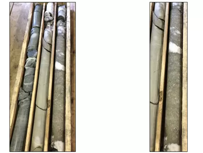
PJX Resources Inc. (TSXV:PJX) has discovered massive sulphide containing anomalous cobalt, copper, nickel, and silver in a quartz-dolomite gangue within metasediments. This mineralization appears to be similar in style to the mineralization found at the Black Butte copper-cobalt deposit, located to the south in Montana (refer to Photo-A and Fig. 1).
The discovery was made during the drilling of Mobile-MT electromagnetic (EM) and magnetic geophysical anomalies at the Lewis Ridge target in late 2022 on the Dewdney Trail Property. The mineralization is situated approximately 3 kilometres north of alkalic intrusive-related gold-copper-silver mineralization at PJX’s Estella Basin target, which was previously announced in the Sullivan Mining District and Vulcan Gold Belt of southeastern British Columbia, Canada.
John Keating, President of PJX commented in a press release: “This was the first phase of drilling to test EM and magnetic anomalies at the more than 2.5 km long and 1.5 km wide Lewis Ridge target area. Our initial thinking was that geophysics identified potential Sullivan-type zinc-lead-silver mineralization. However, drilling has discovered potential for sediment hosted copper-cobalt type deposits possibly similar to those that occur east of Butte, Montana. PJX plans to further explore and drill the Lewis Ridge copper-cobalt target area, and the previously announced new Estella Basin intrusive-related gold-copper-silver target area this year.”
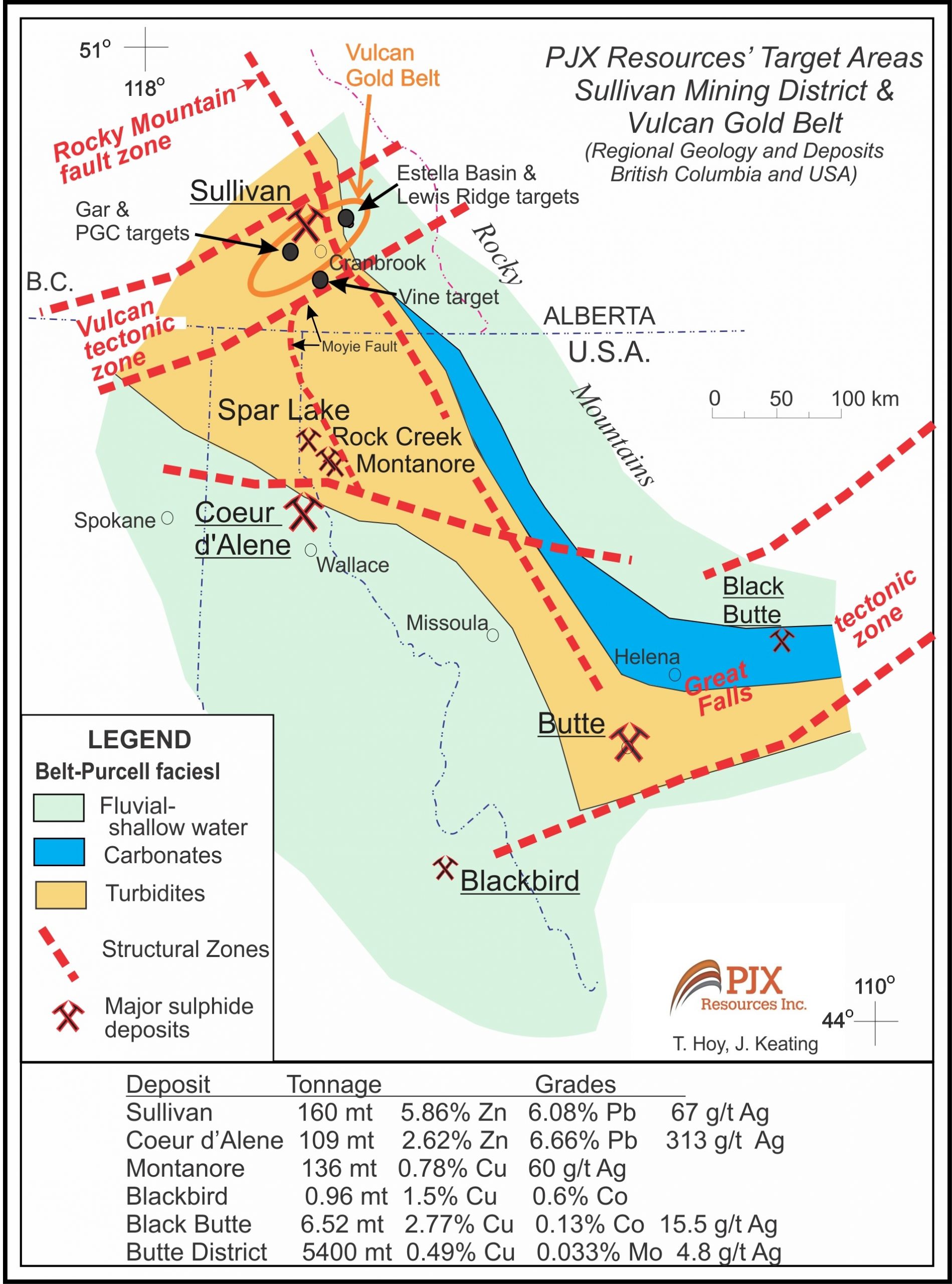
Background
Geology
- Four holes (LR22-01 to LR22-04) were drilled late last year at the Lewis Ridge target to test EM and magnetic anomalies defined by an airborne Mobile-MT (EM) and Magnetic survey flown for PJX by Expert Geophysics.
- Hole LR22-02 intersected massive sulphide mineralization consisting of fine to coarse grained pyrite that has a somewhat net-textured appearance and is fractured or brecciated possibly due to folding (see Photo A above).
- The 1.42 m wide (drill width) zone with 60% massive sulphide in quartz-dolomite gangue was intersected from 125.87m to 127.29 m down hole, and analyzed 644 ppm (0.06%) Co, 819 ppm (0.08%) Cu, 144 ppm Ni and 2.66 ppm (2.6 g/t) Ag.
- The sulphide zone appears bedding parallel and possibly stratabound similar to Black Butte massive pyrite mineralization containing Co, Cu, with anomalous Ni and Ag.
- Black Butte massive pyrite locally contains tennantite (arsenic mineral); Lewis Ridge massive sulphide has 1187 ppm arsenic.
- Black Butte occurs with black shales that are correlative with the middle Aldridge geological formation. Lewis Ridge target occurs at the base of locally black graphitic and/or calcareous silts and argillites of the middle Aldridge.
- Black Butte occurs in the Helena Embayment, a shallow water environment on the east side of the Belt-Purcell rift basin and east of the Butte intrusive related Cu-Molybdenum-Ag deposits. The Lewis Ridge target area is a shallow water environment on the east side of the Belt-Purcell basin, and east of the Sullivan sediment hosted Zn-Pb-Ag deposit (see Fig. 1).
- Black Butte mineralization is associated with an east-west fault called Volcano Valley. The east-west Kimberley Fault influenced the formation of the Sullivan Deposit. The Jackleg fault at Lewis Ridge may be the eastern extension of the Kimberley fault (see Fig 2) Volcano Valley, Kimberley and Jackleg are all considered to be transverse faults in the Belt-Purcell basin.
- Lewis Ridge Target occurs along a large north-south oriented west dipping overturned anticline, and at the equivalent geological time to the Sullivan deposit located about 25 km to the west (see Fig. 3).
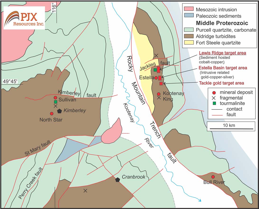
Geophysics – Drilling
- The Lewis Ridge zone with massive pyrite, and the overlying locally graphitic and/or calcareous sedimentary rocks are both conductive rock units. Their conductive nature help explain the large EM apparent conductivity geophysical anomaly. However, the 2 units, along with mafic sills intersected, are not magnetic and do not appear to account for magnetic anomalies (see Fig. 4).
- Cu-Co deposits also occur in Idaho. Pyrite is known to replace pyrrhotite in some of these deposits. Pyrrhotite is often magnetic. If the same type of replacement occurs at Lewis Ridge, then any pyrrhotite not replaced by pyrite may generate a magnetic anomaly.
- Hole LR22-01, drilled toward the northeast (Az 047, dip -75), intersected locally graphitic and calcareous sediments above the quartz-carbonate zone from 111.67-116.12 m. The 4.45m (drill width) zone contained minor sulphide veins and a weighted average analysis of 2410 ppm Cu with low Co, Ni, and Ag.
- Hole LR22-02, was drilled toward the southwest (Az 227, dip -80) from the same drill pad as LR22-01.
- Hole LR22-03, was also drilled toward the southwest (Az 227, dip -45) and encountered what appear to be west dipping faults and was abandoned when the hole was becoming stuck in a fault zone.
- Hole LR22-04, was drilled toward the northeast (Az 047, dip -80) to drill across the west dipping faults and test the large EM and somewhat coincident magnetic anomaly at depth (see Fig. 4 and 5). The 800 m hole drilled along the eastern limb of the overturned anticline fold and across a series of faults. This resulted in the hole remaining within the locally graphitic and/or calcareous sediment unit, and therefore did not test the potential horizon with cobalt and copper mineralization at depth that is stratigraphically lower.
The above references an opinion and is for information purposes only. It is not intended to be investment advice. Seek a licensed professional for investment advice. The author is not an insider or shareholder of any of the companies mentioned above.
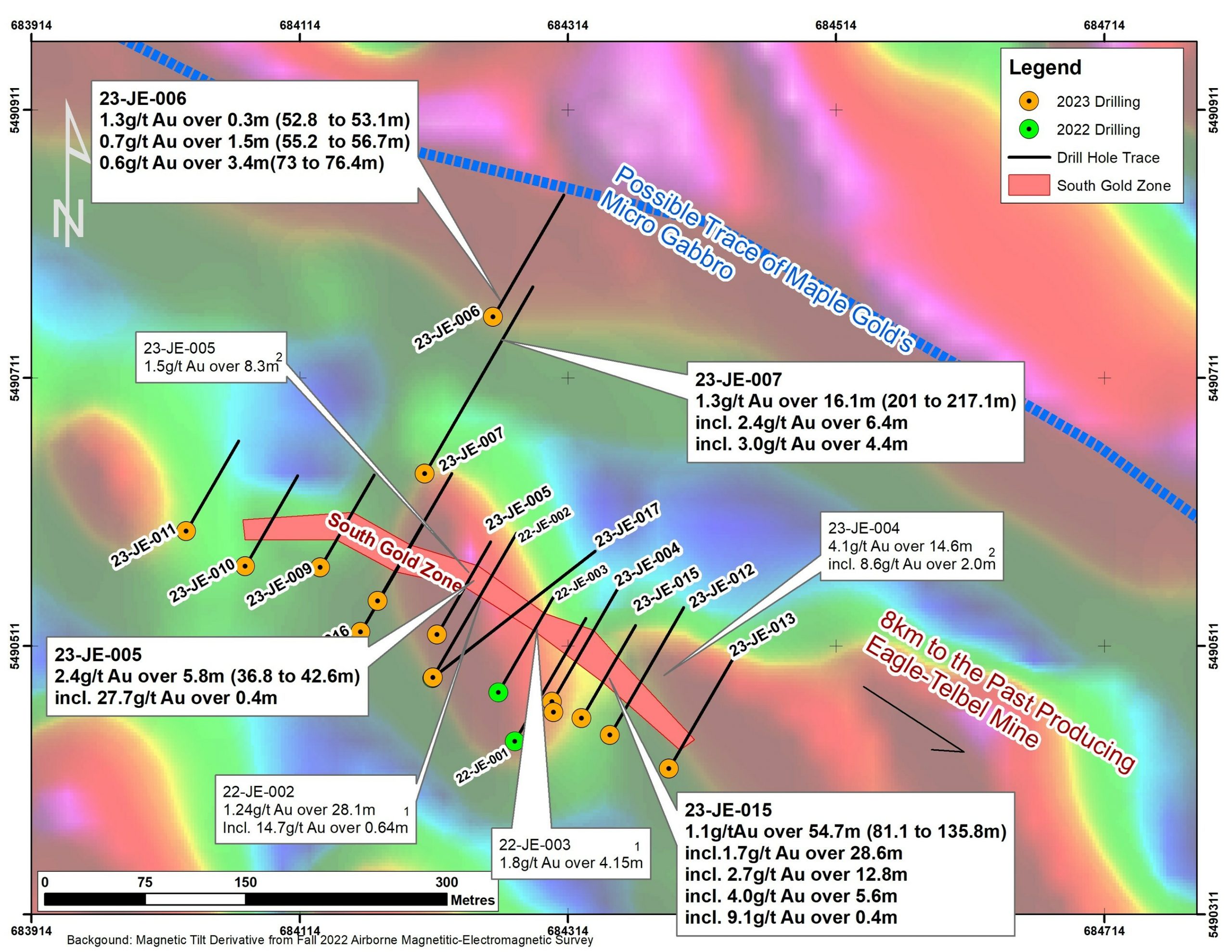
Orford Mining Corporation (TSXV:ORM) has announced exciting news for its Joutel Eagle Property, located in Quebec, as the company has potentially discovered a new gold-bearing horizon. The discovery was made 150 meters north of the South Gold Zone, and it is believed to hold a significant amount of gold.
The discovery was made through the recently drilled hole 23-JE-007, which reported 1.3 g/t Au over 16.1 meters from 201.0 meters. The hole also recorded higher-grade intervals of up to 4.5g/t Au over 1.1 meters. The area where the discovery was made had not been previously explored, and it provides a promising opportunity for further exploration in the region.
David Christie, President and CEO of Orford, commented, “The 2023 drill campaign on our Joutel Eagle property has proven that the property has tremendous potential value with the discovery of a new zone 150 metres to the north of the South Gold Zone. Drilling on the South Gold Zone continues to prove mineralized continuity along strike which was the main purpose of the program.”
In addition to the new discovery, hole 23-JE-015, drilled in the South Gold Zone, reported 1.10g/t Au over 54.7 meters. Higher-grade intervals of up to 9.1g/t over 0.4 meters were also found in this hole. This hole was drilled 25 meters southeast of the previously reported results from hole 23-JE-004, which recorded 14.6 meters of 4.1 g/t.
While the majority of assays from the 2023 drill program are still pending, these early results are very promising for the Joutel Eagle Property. It is important to note that all drilling intervals are down-hole lengths, and true thicknesses cannot be estimated with the information currently available.
The potential new gold-bearing horizon and the positive results from hole 23-JE-015 represent significant progress for Orford Mining Corporation in its efforts to explore the Joutel Eagle Property. These discoveries could lead to the identification of additional gold deposits, which could significantly increase the value of the property.
Located along the Casa-Berardi Structural Zone and the historical Eagle-Telbel Mine Trend in the Abitibi Greenstone belt, the Joutel Eagle Property has proven to be an excellent location for gold mining. Orford Mining Corporation has recently drilled a total of 14 holes and 2,535 meters in 2023 on the property, testing a 400-meter strike of the South Gold Zone.
Both the 20221 and preliminary 20232 drilling results Orford received to date have shown that the South Gold Zone holds higher-grade gold over wider intersections than had been previously reported. Holes 23-JE-007 and 23-JE-006 were drilled to test the possibility of parallel mineralized horizons to the north of the South Gold Zone and possible cross-structural corridors that could contribute to concentrating gold mineralization on the property.
The gold results obtained from these holes (Table 1) have successfully demonstrated the occurrence of additional gold mineralized zones in addition to the thick South Gold Zone results. The remaining assays are pending, and a full structural interpretation will be completed once all data has been received. This interpretation will help identify additional targets in the South Gold Zone, secondary targets associated with structures hosting higher grades oblique to the South Gold Zone, and other targets along strike and parallel to the South Gold Zone to the northwest and southeast along the Eagle mine horizon.
Table 1: Highlight of Joutel Eagle Drill hole assays received to date. All drilling intervals are downhole lengths. True thicknesses cannot be estimated with available information. Composited intervals are reported at a cut-off of 0.5g/t Au.
|
From (m) |
To (m) |
Interval (m) |
Gold (g/t) |
||
|
23-JE-004 |
100.3 |
114.9 |
14.6 |
4.1 |
Previously Reported February 21, 2023 |
|
including |
106 |
114.8 |
8.8 |
5.8 |
Previously Reported February 21, 2023 |
|
including |
112.8 |
114.8 |
2 |
8.6 |
Previously Reported February 21, 2023 |
|
including |
113.1 |
113.4 |
0.3 |
28.7 |
Previously Reported February 21, 2023 |
|
23-JE-004 |
128.8 |
158.9 |
30.1 |
1.1 |
Previously Reported February 21, 2023 |
|
including |
132.8 |
145.1 |
12.3 |
1.8 |
Previously Reported February 21, 2023 |
|
including |
134.5 |
138.9 |
4.4 |
2.9 |
Previously Reported February 21, 2023 |
|
including |
142.5 |
144.1 |
1.6 |
2.6 |
Previously Reported February 21, 2023 |
|
23-JE-005 |
36.8 |
42.6 |
5.8 |
2.4 |
NEW |
|
including |
41.5 |
42.8 |
1.3 |
10.9 |
NEW |
|
including |
42.3 |
42.7 |
0.4 |
27.7 |
NEW |
|
23-JE-005 |
53.6 |
56.9 |
3.3 |
2.1 |
NEW |
|
including |
54 |
55.1 |
1.1 |
5 |
NEW |
|
including |
54 |
54.7 |
0.7 |
6.2 |
NEW |
|
23-JE-005 |
85.6 |
93.6 |
8 |
1.5 |
Previously Reported February 21, 2023 |
|
including |
85.6 |
90.4 |
4.8 |
1.8 |
Previously Reported February 21, 2023 |
|
including |
85.6 |
86.5 |
0.9 |
4.6 |
Previously Reported February 21, 2023 |
|
23-JE-006 |
52.8 |
53.1 |
0.3 |
1.3 |
NEW |
|
23-JE-006 |
55.2 |
56.7 |
1.5 |
0.7 |
NEW |
|
23-JE-006 |
73 |
76.4 |
3.4 |
0.6 |
NEW |
|
23-JE-007 |
201 |
217.1 |
16.1 |
1.3 |
NEW |
|
including |
201 |
212 |
11 |
1.8 |
NEW |
|
including |
205.6 |
212 |
6.4 |
2.4 |
NEW |
|
including |
206 |
210.4 |
4.4 |
3.0 |
NEW |
|
including |
206 |
207.1 |
1.1 |
4.5 |
NEW |
|
23-JE-007 |
225.2 |
229.9 |
4.7 |
0.7 |
NEW |
|
including |
229.2 |
229.8 |
0.6 |
2.1 |
NEW |
|
23-JE-015 |
81.1 |
135.8 |
54.7 |
1.1 |
NEW |
|
including |
81.1 |
109.7 |
28.6 |
1.7 |
NEW |
|
including |
82.9 |
88.3 |
5.4 |
2 |
NEW |
|
and |
84.9 |
88.3 |
3.4 |
2.5 |
NEW |
|
including |
86.8 |
88.3 |
1.5 |
3.8 |
NEW |
|
including |
87.9 |
88.3 |
0.4 |
7.4 |
NEW |
|
and |
96.5 |
109.3 |
12.8 |
2.7 |
NEW |
|
including |
102 |
109.3 |
7.3 |
3.5 |
NEW |
|
including |
103.7 |
109.3 |
5.6 |
4.0 |
NEW |
|
including |
103.7 |
104.4 |
0.7 |
7.2 |
NEW |
|
including |
107.6 |
109.3 |
1.7 |
4.7 |
NEW |
|
including |
108.1 |
108.5 |
0.4 |
9.1 |
NEW |
Table 2: Status of Assay Results Received from the 2023 Joutel Eagle Drilling Program (SGZ=South Gold Zone)
|
Hole Number |
Assay Reported (%) |
Area |
|
23-JE-004 |
100 |
SGZ |
|
23-JE-005 |
100 |
SGZ |
|
23-JE-006 |
99.1 |
North Horizon |
|
23-JE-007 |
94.2 |
North Horizon |
|
23-JE-008 |
0 |
SGZ |
|
23-JE-009 |
0 |
SGZ |
|
23-JE-010 |
0 |
SGZ |
|
23-JE-011 |
0 |
SGZ |
|
23-JE-012 |
0 |
SGZ |
|
23-JE-013 |
0 |
SGZ |
|
23-JE-014 |
0 |
SGZ |
|
23-JE-015 |
50 |
SGZ |
|
23-JE-016 |
0 |
SGZ |
|
23-JE-017 |
0 |
SGZ |
Table 3: Joutel Eagle: South Gold Zone Drill Hole Coordinates (UTM NAD83 Zone 17)
|
Hole ID |
X |
Y |
Length (m) |
Azimuth |
Dip |
|
23-JE-004 |
684302 |
5490470 |
195 |
30 |
60 |
|
23-JE-005 |
684216 |
5490520 |
159 |
30 |
60 |
|
23-JE-006 |
684258 |
5490757 |
163 |
30 |
50 |
|
23-JE-007 |
684207 |
5490640 |
252 |
30 |
50 |
|
23-JE-008 |
684172 |
5490545 |
192 |
30 |
55 |
|
23-JE-009 |
684129 |
5490570 |
159 |
30 |
60 |
|
23-JE-010 |
684073 |
5490571 |
156 |
30 |
60 |
|
23-JE-011 |
684029 |
5490597 |
155 |
30 |
60 |
|
23-JE-012 |
684345 |
5490445 |
219 |
30 |
60 |
|
23-JE-013 |
684389 |
5490420 |
189 |
30 |
60 |
|
23-JE-014 |
684303 |
5490462 |
156 |
30 |
50 |
|
23-JE-015 |
684324 |
5490458 |
159 |
30 |
60 |
|
23-JE-016 |
684159 |
5490522 |
162 |
30 |
55 |
|
23-JE-017 |
684303 |
5490462 |
219 |
58 |
57 |
|
2535 |
Total m |
The above references an opinion and is for information purposes only. It is not intended to be investment advice. Seek a licensed professional for investment advice. The author is not an insider or shareholder of any of the companies mentioned above.
Solaris Resources Inc. (TSX:SLS) (OTCQB:SLSSF) has released assay results from several holes with the goal of expanding mineral resources and detecting a new, more concentrated porphyry center that could potentially extend to the south of the Warintza East discovery at the Warintza Project in southeastern Ecuador. The key findings, illustrated in Figure 1 and presented in Tables 1-2, are outlined below.
Mr. Jorge Fierro, Vice President, Exploration, commented in a press release: “Drilling to date confirms Warintza East as a significant porphyry deposit that adjoins Warintza Central and remains open for expansion, with a particular direction of focus to the south where extensional and step-out drilling is targeting higher grade mineralization associated with a newly identified southern porphyry center.”
Highlights from the results are as follows:
Warintza East was discovered in July 2021, with only eight holes completed prior to the cut-off for inclusion in the Warintza Central Mineral Resource Estimate (“MRE”)¹ in April 2022. Subsequent drilling has significantly expanded the dimensions of the deposit to the north, east and south, where it remains open. Recent drilling has now validated a southern vector toward stronger soil anomalism, identifying a second porphyry center producing higher grade mineralization and opening up further expansion potential in this direction.
- SLSE-23 was collared in the middle of the Warintza East drill grid and drilled north, returning 626m of 0.50% CuEq² from surface within a broader interval of 746m of 0.46% CuEq², expanding the footprint to the north where it remains open
- SLSE-24 was collared at the southeastern limit of the grid and drilled southwest into an open volume, returning 156m of 0.52% CuEq² from near surface within a broader interval of 410m of 0.30% CuEq², extending mineralization to the southwest where it remains open
- SLSE-20 was collared in the middle of the drill grid and drilled east, returning 292m of 0.45% CuEq² from surface within a broader interval of 900m of 0.30% CuEq², expanding the footprint to the east where it remains open
- SLSE-21 was collared at the southeastern limit of the grid and drilled east, returning 198m of 0.40% CuEq² within a broader interval of 1,040m of 0.33% CuEq² from surface, extending mineralization to the east where it remains open
- SLSE-25 was collared from a new central platform and drilled vertically with a small drill rig specifically used for infill purposes, returning 110m of 0.46% CuEq² from 32m depth within a broader interval, upgrading this area with near surface, high-grade mineralization
- Identification of a second porphyry center in SLSE-28, with visual interpretation suggesting potential for some of the strongest grades to date at Warintza East – the new porphyry center is located south of SLSE-22, which exited a weakly mineralized dyke into stronger mineralization over its final 40m, consistent with increased grades observed from SLSE-16 in this area (192m of 0.70% CuEq² from 350m depth within a broader interval of 712m of 0.45% CuEq² – refer to press release dated January 17, 2023)
Table 1 – Assay Results
| Hole ID | Date Reported | From (m) |
To (m) |
Interval (m) |
Cu (%) |
Mo (%) |
Au (g/t) |
CuEq² (%) |
| SLSE-25 | Apr 3, 2023 | 0 | 300 | 300 | 0.21 | 0.02 | 0.03 | 0.30 |
| Including | 32 | 142 | 110 | 0.35 | 0.02 | 0.03 | 0.46 | |
| SLSE-24 | 10 | 420 | 410 | 0.23 | 0.01 | 0.04 | 0.30 | |
| Including | 18 | 242 | 224 | 0.33 | 0.02 | 0.06 | 0.43 | |
| Including | 26 | 182 | 156 | 0.41 | 0.02 | 0.07 | 0.52 | |
| SLSE-23 | 0 | 746 | 746 | 0.36 | 0.02 | 0.04 | 0.46 | |
| Including | 0 | 626 | 626 | 0.40 | 0.02 | 0.05 | 0.50 | |
| SLSE-22 | 26 | 1080 | 1054 | 0.18 | 0.01 | 0.03 | 0.24 | |
| SLSE-21 | 0 | 1040 | 1040 | 0.26 | 0.01 | 0.04 | 0.33 | |
| Including | 92 | 290 | 198 | 0.33 | 0.01 | 0.04 | 0.40 | |
| SLSE-20 | 0 | 900 | 900 | 0.24 | 0.01 | 0.03 | 0.30 | |
| Including | 4 | 296 | 292 | 0.35 | 0.02 | 0.04 | 0.45 | |
| SLSE-16 | Jan 17, 2023 | 8 | 720 | 712 | 0.36 | 0.02 | 0.05 | 0.45 |
| Including | 76 | 184 | 108 | 0.46 | 0.02 | 0.06 | 0.57 | |
| Including | 350 | 542 | 192 | 0.59 | 0.02 | 0.07 | 0.70 |
Notes to table: True widths of the mineralized zone are not known at this time.
Table 2 – Collar Location
| Hole ID | Easting | Northing | Elevation (m) |
Depth (m) |
Azimuth (degrees) | Dip (degrees) |
| SLSE-25 | 801489 | 9648125 | 1170 | 300 | 0 | -90 |
| SLSE-24 | 801684 | 9648074 | 1221 | 722 | 250 | -65 |
| SLSE-23 | 801485 | 9648192 | 1170 | 748 | 0 | -80 |
| SLSE-22 | 801453 | 9647971 | 1234 | 1083 | 165 | -80 |
| SLSE-21 | 801684 | 9648074 | 1221 | 1071 | 90 | -82 |
| SLSE-20 | 801485 | 9648192 | 1170 | 905 | 90 | -65 |
| SLSE-16 | 801684 | 9648074 | 1221 | 845 | 225 | -45 |
| Notes to table: The coordinates are in WGS84 17S Datum. | ||||||
The above references an opinion and is for information purposes only. It is not intended to be investment advice. Seek a licensed professional for investment advice. The author is not an insider or shareholder of any of the companies mentioned above.
If you would like to receive our free newsletter via email, simply enter your email address below & click subscribe.
 Follow us on Twitter
 Become our facebook fan
CONNECT WITH US
Tweets
Tweet with hash tag #miningfeeds or @miningfeeds and your tweets will be displayed across this site.
MOST ACTIVE MINING STOCKS
Daily Gainers
 CMC Metals Ltd. CMC Metals Ltd. |
CMB.V | +900.00% |
 Eden Energy Ltd Eden Energy Ltd |
EDE.AX | +200.00% |
| GoviEx Uranium Inc. |
GXU.V | +42.86% |
| Eagle Nickel Ltd. |
ENL.AX | +41.67% |
| Citigold Corp. Limited |
CTO.AX | +33.33% |
| Mount Burgess Mining NL |
MTB.AX | +33.33% |
| Exalt Resources Limited |
ERD.AX | +31.94% |
| Casa Minerals Inc. |
CASA.V | +30.00% |
| Cariboo Rose Resources Ltd |
CRB.V | +28.57% |
| Belmont Resources Inc. |
BEA.V | +28.57% |