Solaris Resources (TSX:SLS) (OTCQB:SLSSF) has launched an extensive 2024 drilling and exploration program at its Warintza copper-gold project in southeastern Ecuador, aiming to substantially increase the current mineral resource estimate, make additional new discoveries, and advance infrastructure and engineering studies to further derisk what it hopes will become Ecuador’s next major mining operation.
With six drill rigs slated to be spinning by month’s end, Solaris is wasting no time following up on the successes of last year’s drilling efforts which outlined wide zones of high-grade mineralization over a 5km strike. The priority targets are the open-ended higher grade core at Warintza Central, extending the strike length and depth at the Warintza East discovery, and delineating an initial resource at the Warintza Southeast discovery made last fall.
An updated mineral resource estimate incorporating almost twice the results of the previous estimate is expected by late Q2. The additional data, especially from East and Southeast, could substantially increase the overall resource scale and grade. Warintza’s position among the ranks of major global copper projects may soon be cemented if this is the case.
But Solaris isn’t resting on this plan, with plans to keep drilling through the updated resource estimate and an aim of completing at least 30,000 additional meters focusing on further growth opportunities by yearend 2024. This includes tightening the drill pattern in some areas with room for optimization, as well as collecting data for preliminary metallurgical, geotechnical and hydrological studies to support future scoping and feasibility studies.
Systematic Regional Exploration Underway to Make Next Big Discovery
On a parallel track beyond the main Warintza deposits, field crews have mobilized to several earlier-stage regional targets with hopes of making Solaris’ next big porphyry discovery elsewhere on its large concession package outside of Warintza Central. Initial soil sampling and mapping programs over the past two years have revealed a number of intriguing copper-molybdenum anomalies that could indicate the presence of additional blind porphyries underlying the sandstone cover prevalent in the basin.
The immediate focus is on the Mateo prospect, where recent sampling outlined a sizable 3km x 1.4km copper-in-soils anomaly coincident with sandstone outcrops. Further infill soil sampling and possibly some initial geophysical surveys are planned over the coming months to refine the targets for an eventual maiden drill campaign later this year or early 2025. Several other early-stage regional targets are also on the agenda for Solaris’ exploration team.
Well-Funded for Full Campaign
With a recent $130 million strategic investment from China’s Zijin Mining Group now in hand, Solaris is well-funded to potentially ramp up and accelerate its plans over the next two years. In fact, beyond the six rigs currently operating, the company has targets to get as many as ten rigs spinning by the end of 2024 to systematically test the full breadth of what it has now in its crosshairs – a district-scale opportunity centered around Warintza but extending across its vast concession holdings in Ecuador.
Zijin identified world-class potential after taking a 15% stake in Solaris Resources, and, in addition to providing critical capital, Zijin also brings substantial technical expertise and experience to the table as one of China’s preeminent mining firms operating globally.
With renewed financial backing and drills now turning, Solaris Resources is intent on methodically unlocking the full promise of its Ecuadorian property package in 2024. The company’s near-term resource growth drilling, regional exploration campaigns, infrastructure studies, and new high-profile partnership with Zijin Mining set the stage for what could prove a potentially company-making year. Investors can likely expect a steady stream of news flow over the coming year, and further updates to this copper growth story.
The above references an opinion and is for information purposes only. It is not intended to be investment advice. Seek a licensed professional for investment advice. The author is not an insider or shareholder of any of the companies mentioned above.
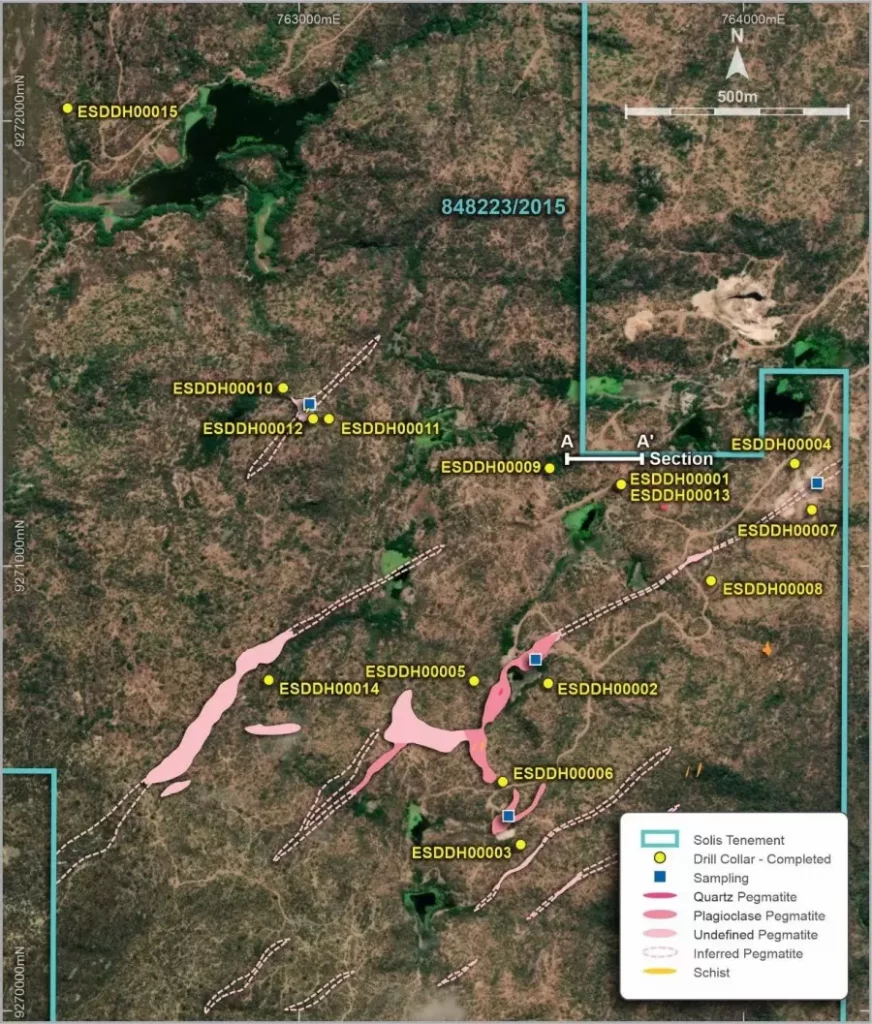
Solis Minerals (ASX:SLM) (TSXV:SLMN) (OTCQB: SLMFF) has announced an update on its recent drilling program at the Estrela and Mina Vermelha prospects in Borborema, Brazil.
The company completed 15 drillholes totaling 2,082 meters at the Estrela targets, testing six different pegmatite bodies down to depths of up to 204 meters below surface. Assay results received so far from the first four drillholes show no significant lithium values, with the highest assay being 0.07% Li2O over 1 meter from 89.2 to 90.2 meters downhole in ESDDH00001.
At the Mina Vermelha prospect, Solis completed eight drillholes (with one hole abandoned) totaling 1,609 meters, testing a 2 kilometer strike length of known pegmatites. Four drillholes have been assayed, again showing no significant lithium results.
The company states that all the major outcropping mineralized bodies at Estrela and Mina Vermelha have now been tested, and no further exploration drilling is planned in the near future.
In other exploration work, Solis reports that approximately 50% of a major regional geochemical soil sampling program has been completed by contractors GMT Exploration Services in the northern Borborema Province. So far, 270 samples have been submitted for analysis, with another 300 samples prepared and ready to be submitted. Assay results from the full program will help identify new drill targets within Solis’ extensive land holdings in the region. The sampling program is scheduled for completion in early 2024.
Solis is awaiting assay results in February 2023 for the remaining 16 drillholes from the recent Estrela and Mina Vermelha campaigns. Results from the regional soil sampling program are expected in March 2024.
The company says it continues to review other exploration projects for various minerals in Brazil and elsewhere. Further updates will be provided to the market when appropriate.
Solis Minerals Limited is a mineral exploration company focused on lithium and other energy metals in Brazil. The company holds over 710 square kilometers of mineral rights in the Borborema province of northeastern Brazil. Solis aims to develop a low-cost source of lithium concentrates to supply the growing demand from battery manufacturers and the electric vehicle industry.
Executive Director, Matthew Boyes, commented in a press release: “Drilling has now been completed and rigs are demobilising from the Borborema project area. The initial results have not met expectations from either Estrela or Mina Vermelha projects despite the early potential demonstrated by surface exploration and the proximity to known lithium bearing systems. Both projects represented a relatively low cost option for the company with funds directed predominantly into the drilling programs. This targeting funding has allowed us to efficiently evaluate the potential of the assets before committing to subsequent payments. Solis is continually evaluating new potential acquisitions, including opportunities in Borborema, Minas Gerais to the south, and expansion of our copper portfolio in Peru. This strategy of using earn-in option agreements will continue to be used, allowing exploration and drilling spending to be prioritised.”
Highlights from the results are as follows:
- Maiden drilling programmes now completed at both the Estrela and Mina Vermelha lithium pegmatite projects for a total 3,691m.
- Assays returned for the first eight holes reported no significant lithium from either project.
- Assays remain pending for final sixteen holes and will undergo review before a decision to recommence additional exploration.
- Solis continues to evaluate potential new project acquisitions.
- Solis remains well funded with circa AUD $7M in funds at the end of 2023.
The above references an opinion and is for information purposes only. It is not intended to be investment advice. Seek a licensed professional for investment advice. The author is not an insider or shareholder of any of the companies mentioned above.
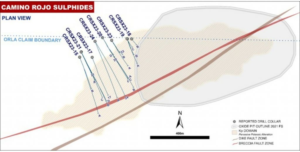
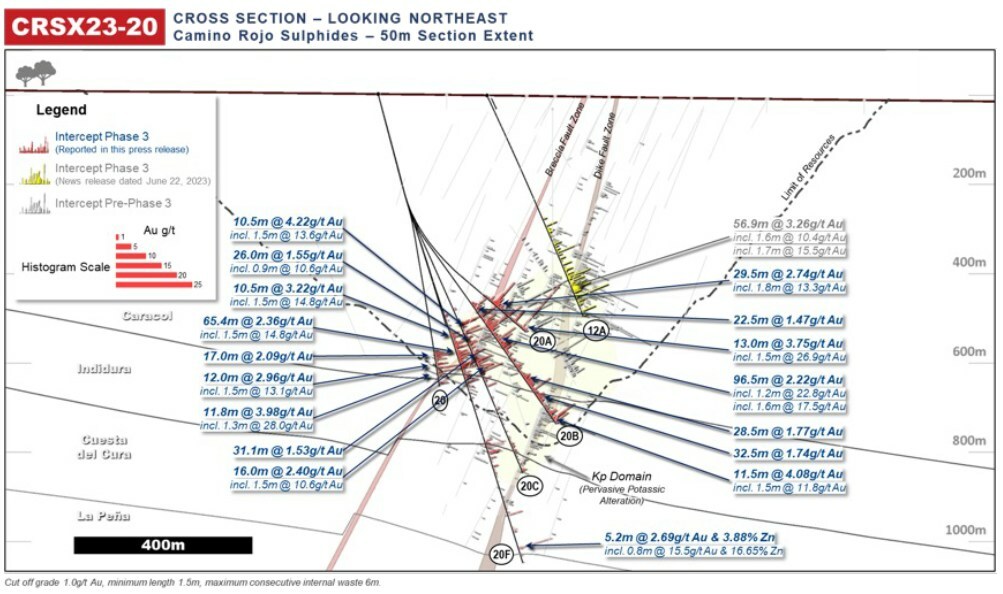
Orla Mining Ltd. (TSX:OLA) has provided an update on its 2023 exploration activities at the Camino Rojo Sulphides project in Zacatecas State, Mexico.
In 2023, Orla completed a 37,677-metre drill program focused on infilling higher grade portions of the current Camino Rojo Sulphides open pit mineral resource. The primary goals were to improve geological understanding of mineralization controls and test for depth extensions of sulphides below the existing resource, referred to as the Camino Rojo Extension target.
Sylvain Guerard, Orla’s Senior Vice President, Exploration, commented in a press release: “New drill results at Camino Rojo are revealing more about controls on mineralization and hinting at potential for significant expansion below the current Mineral Resource in the Camino Rojo Extension. This data is crucial for our upcoming underground resource estimation, enhancing our understanding of this important part of our growth pipeline.”
Previously on June 22, 2023, Orla released results from 15 of 56 holes from the Sulphides infill program. This news release presents results from an additional 23 drill holes, with assays pending from the remaining 18 holes expected over the coming weeks.
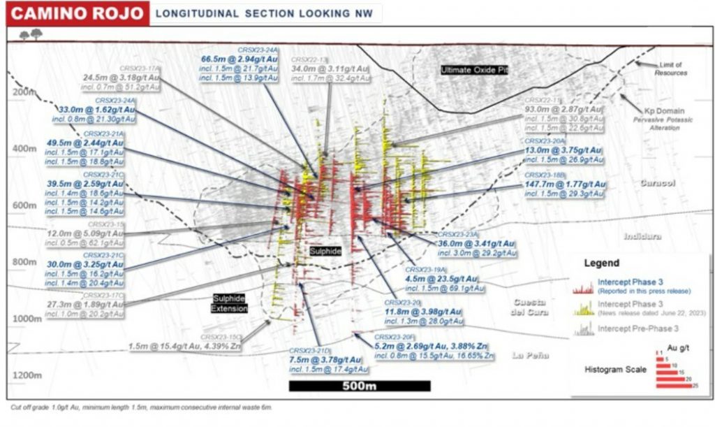
Overall, infill drilling has consistently intersected long downhole intervals exceeding 30 metres grading over 2.0 g/t gold. These results validate previous drilling and support the potential for underground mining. Recent highlights include high-grade intercepts over 0.7 to 3.0 metres exceeding 10 g/t gold, hosted within broader intervals grading over 2.0 g/t gold. These high-grade zones underscore the opportunity for more selective, high-value underground mining.
Looking ahead to 2024 exploration plans, Orla will shift focus to testing the extensive depth potential at Camino Rojo, including the Camino Rojo Extension target below the existing sulphides resource. A 30,000-metre drill program is planned to further investigate this compelling target.
Orla’s 2023 infill drilling has successfully improved geological knowledge and expanded prospective areas for sulphide mineralization at Camino Rojo. Pending final assays, the Company will evaluate results towards its goal of generating an initial underground mineral resource estimate. With positive results to date, Orla remains committed to unlocking the extensive exploration upside through systematic drilling in 2024 and beyond.
Highlights from the results are as follows:
- 3.41 g/t Au over 36m, incl. 29.2 g/t Au over 3.0 m,
- 2.94 g/t Au over 66.5 m, incl. 4.98 g/t Au over 16.5 m,
- 2.44 g/t Au over 49.5 m, incl. 4.59 g/t Au over 21.0 m, and
- 2.22 g/t Au over 96.5 m, incl. 3.24 g/t Au over 33.9 m
|
Camino Rojo Sulphides |
|
|
Hole CRSX23-17 incl. |
2.54 g/t Au over 68.5m 13.1 g/t Au over 1.5 m |
|
Hole CRSX23-19C: incl. and incl. and incl. |
2.08 g/t Au over 124.5 m 2.46 g/t Au over 60.0 m, and incl.11.7 g/t Au over 1.5 m 11.7 g/t Au over 3.0 m 3.11 g/t Au over 20.5 m |
|
Hole CRSX23-20B: |
2.22 g/t Au over 96.5 m incl. 3.24 g/t Au over 33.9 m incl. 12.8 g/t Au over 1.2 m and incl. 17.5 g/t over 1.6 m |
|
Hole CRSX23-20F: |
2.36 g/t Au over 65.4 m, incl. 2.77 g/t Au over 13.5 m, 2.86 g/t Au over 36.5 m and incl. 14.8 g/t Au over 1.5 m |
|
Hole CRSX23-21A: |
2.44 g/t Au over 49.5 m, incl. 4.59 g/t Au over 21.0 m, incl. 17.1 g/t Au over 1.5 m and incl. 18.8 g/t Au over 1.5 m |
|
Hole CRSX23-23A: |
3.41 g/t Au over 36m, incl. 5.94 g/t Au over 18.0m, and incl. 29.2 g/t Au over 3.0 m |
|
Hole CRSX23-24A: |
2.94 g/t Au over 66.5 m, incl. 4.98 g/t Au over 16.5 m incl. 21.7 g/t Au over 1.5 m and incl. 13.9 g/t Au over 1.5 m |
The above references an opinion and is for information purposes only. It is not intended to be investment advice. Seek a licensed professional for investment advice. The author is not an insider or shareholder of any of the companies mentioned above.
The McClean Lake uranium mine, located in the Athabasca Basin of northern Saskatchewan, is set to resume production in 2025 after operations were suspended in 2008 due to weak uranium prices. Joint venture partners Denison Mines and Orano Canada announced on Wednesday that mining activities will restart at the McClean North deposit, with an estimated 800,000 pounds of uranium output expected in 2025.
The McClean Lake mine is owned by the McClean Lake Joint Venture (MLJV), in which Denison Mines holds a 22.5% stake and Orano Canada, as operator, holds a 77.5% interest. The partners have continued exploration activities and invested in developing the patented Surface Access Borehole Resource Extraction (SABRE) mining method, which is designed to selectively extract high-grade uranium ore.
Preparations in 2024 will involve getting the existing SABRE mining infrastructure and equipment ready for continuous commercial operations. MLJV will also install eight pilot holes for the first mining cavities to be excavated.
Beyond 2025, the joint venture partners have identified the potential for around 3 million additional pounds of uranium production from 2026 to 2030, drawing from both the McClean North and Caribou deposits at the mine site.
The decision to restart operations reflects improving project and uranium market fundamentals, according to the companies. Alexander Pearce, a uranium analyst with BMO Capital Markets, noted the restart would help provide modest near-term cash flow for Denison as it develops the Wheeler River project.
Orano Canada President and CEO Jim Corman said the joint venture’s ability to capitalize on strengthening nuclear and uranium markets is due to long-term R&D investments enabling continued activities at McClean Lake.
The McClean Lake property, located approximately 750 km north of Saskatoon, consists of 4 mineral leases covering 1,147 hectares and 13 mineral claims over 3,111 hectares.
Uranium prices recently hit their highest levels in over 16 years, largely driven by major global producer Kazatomprom highlighting potential supply risks. This price resurgence is expected to incentivize restarts of idled uranium mining capacity globally.
Jim Corman, Orano Canada’s President and Chief Executive Officer, commented in a press release: “Our current ability to capitalize on the strengthening uranium and nuclear markets is the result of a long-term investment in R&D within Orano and the MLJV to secure continued activities at the McClean Lake operation well into the future. The groundwork we do over the course of 2024, is expected to put the MLJV in position to see SABRE in action and to commence production in 2025. It is anticipated that the McClean Lake mill will have sufficient capacity to process this ore, while continuing with committed planned production from Cigar Lake. It’s an exciting time for employees, partners, and the industry as we return to a focus on growth.”
David Cates, Denison’s President and Chief Executive Officer, also commented in the press release: “The restart of uranium mining at McClean Lake is a notable milestone for the MLJV and Denison. Mining at McClean Lake was suspended in 2008 in response to declining uranium prices. During the interim 15 years, the MLJV invested in the development of a proprietary mining method designed to selectively extract high-grade Athabasca Basin uranium ores from surface. The successful mining test of the SABRE method in 2021 provided the MLJV with important information about the productivity and cost of SABRE operations. This information suggests an incentive price meaningfully lower than current uranium prices, which has provided the JV with a strong basis to make a restart decision for mining at McClean Lake.
The McClean Lake mine first opened in 1999 and produced over 50 million pounds of uranium through its suspension in 2008. The planned restart marks a major step in re-establishing northern Saskatchewan as a key uranium mining region amid rising market demand.
The above references an opinion and is for information purposes only. It is not intended to be investment advice. Seek a licensed professional for investment advice. The author is not an insider or shareholder of any of the companies mentioned above.
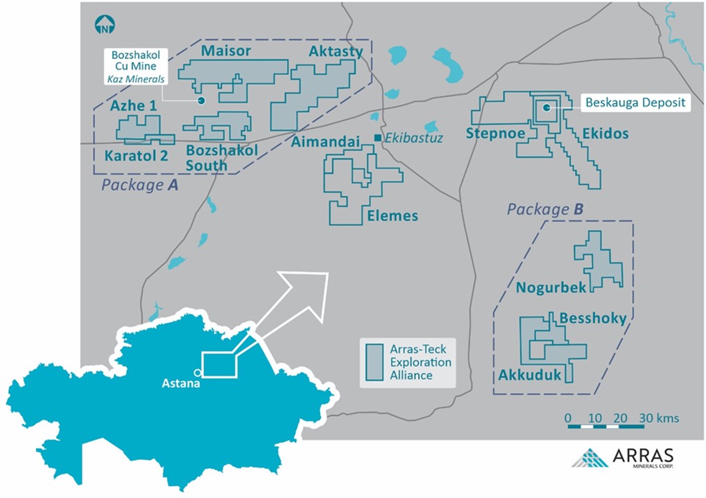
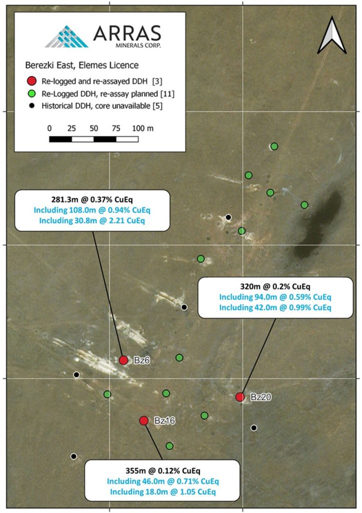
Arras Minerals (TSXV:ARK) has announced promising results from the re-analysis of samples from three historic diamond drill holes from the Berezski East project located within the Company’s Elemes exploration licence in northeastern Kazakhstan. The 425 square kilometre Elemes mineral exploration license, which hosts the Berezski East project, is located approximately 80 kilometres east of Arras Minerals’ flagship Beskauga copper-gold deposit and is not included in the Teck-Arras Strategic Exploration Alliance.
Tim Barry, CEO of Arras Minerals, commented in a press release: “The recent re-analysis program at Berezski East and Quartzite-Gorka has underscored the promising mineralizing system developing within our Elemes Licence. Our efforts over the past year have revealed a significant at-surface zone of mineralization, extending across a 5-kilometre strike, with potential expansions in every direction. To date, key areas of interest include “porphyry style” mineralization found at the Berezski East, Berezski Central, and Quartzite Gorka prospects, and “epithermal style” mineralization found at the Karagandy-Ozek prospect. Re-logging and re-assay of historic drill holes has verified intercepts of high-grade of mineralization often exceeding 100 meters in thickness and often starting from surface. It is also important to note that many of historical drill holes end in mineralization as most of the drilling was quite shallow, averaging between 200-300 meters in depth.”
The Elemes licence is situated within the highly productive Bozshakol-Chingiz metallogenic belt in northeastern Kazakhstan that also hosts KAZ Minerals’ large Bozshakol porphyry copper-gold mine located roughly 60 kilometers northwest of Berezski East. The Elemes license benefits from excellent infrastructure, including close proximity to Arras Minerals’ operational base in the nearby city of Ekibastuz. A paved highway and heavy rail lines lie within 15 kilometers of Berezski East, while 1100 KVA power lines run within 1 kilometer of the project area.
Between 2007 and 2010, the previous operators at Berezski East completed 19 diamond drill holes totaling 5,695 metres, with an average depth of 299.7 meters per hole. Mineralization at Berezski East remains open along strike and at depth based on the results of the historical drilling. Arras Minerals has acquired all available drill core and coarse rejects from the previous operators’ drilling campaigns and has relocated the materials to the Company’s core storage facility in Ekibastuz for detailed re-logging and analysis.
Arras Minerals’ technical team has re-logged the available historical drill core from Berezski East in order to systematically document lithology, structure, alteration, and mineralization characteristics. These core re-logging results, combined with the encouraging re-assaying of coarse rejects from historical drilling, have provided valuable insights into the geology and metallogenesis of the Berezski East mineral system.
The style of mineralization identified at Berezski East is interpreted by Arras geologists to represent part of a larger gold-rich porphyry copper-gold district within the Elemes licence area. Additional prospects identified to date on the Elemes property include Berezski Central, Quartzite Gorka, and Karagandy-Ozek.
The re-analysis work by Arras of coarse rejects from three historical drill holes at Berezski East confirms the presence of high-grade gold, copper and silver mineralization. Individual sample assays returned up to 18.0 grams per tonne (g/t) gold (Au), 1.01% copper (Cu) and 47.7 g/t silver (Ag).
The gold-rich mineralization at Berezski East consists of sheeted and stockwork quartz-magnetite-chalcopyrite-bornite veins with associated potassic alteration halos. Additional vein types identified include magnetite-only and quartz-chalcopyrite veins. Disseminated chalcopyrite, bornite and pyrite are also locally present. Late anhydrite and epidote-carbonate veins crosscut the earlier porphyry-style veins.
The Ordovician-aged host diorite intrusion is fine-grained, equigranular and typically highly magnetic. Pervasive potassic alteration (K-feldspar+quartz+magnetite+biotite) affects the diorite locally, overprinted by intermediate argillic alteration (illite+chlorite). An upper oxidized zone exhibits intense kaolinite-iron oxide alteration with minor supergene copper enrichment.
Results from a detailed high-resolution airborne magnetic survey by Arras, along with 3D inversion modeling of the magnetic data, reveal that the known mineralization at Berezski East lies on the margin of a strong northwest-trending magnetic high. This magnetic feature extends towards and links up with the Karagandy-Ozek epithermal gold prospect where Soviet-era exploration reportedly discovered high-grade gold mineralization in trenches. The airborne magnetic survey has greatly improved Arras’ understanding of the structural setting of Berezski East mineralization and has generated compelling new drill targets near known zones of porphyry and epithermal Au-Cu mineralization.
Arras is highly encouraged by the re-analysis results and new geologic insights from its comprehensive re-logging program on the historical drill core from the Berezski East project within the Company’s 100% owned Elemes license. The Company will incorporate these positive developments into upcoming exploration plans for the Elemes property. Arras’ technical team believes Berezski East and the broader Elemes license represent a major new gold-rich porphyry copper-gold district opportunity in northeastern Kazakhstan. Further drilling and exploration work is warranted based on the re-interpretation of the historic Berezski East data and the additional targets defined by the recent airborne magnetic survey. With its close proximity to excellent infrastructure, Berezski East highlights the untapped discovery potential remaining within Arras’ prospective project portfolio in this prolific but under-explored mineral belt.
- Bz6 – 108.0 meters (“m”) of mineralization grading 0.94 % CuEq or 1.33 /t AuEq (1.30 g/t gold (“Au”), 0.19 % copper (“Cu”) and 1.5 g/t silver (“Ag”)) starting at surface.
- Including 30.8 m grading 2.21 % CuEq or 2.66 g/t AuEq (3.14 g/t Au, 0.39 % Cu and 3.0 g/t Ag) starting at surface.
- Bz16 – 46.0 m of mineralization grading 0.71 % CuEq or 0.86 g/t AuEq (0.95 g/t Au, 0.17 % Cu and 0.8 g/t Ag) starting at 87.0 m depth down-hole.
- Including 18.0 m grading 1.05 % CuEq or 1.28 g/t AuEq (1.54 g/t Au, 0.17 % Cu and 0.7 g/t Ag) from 102.0 m depth down-hole.
- Bz20 – 94.0 m of mineralization grading 0.59 % CuEq or 0.71 g/t AuEq (0.81 g/t Au, 0.12 % Cu and 0.9 g/t Ag) starting at 199.0 m depth down-hole.
- Including 42.0 m grading 0.99 % CuEq or 1.20 g/t AuEq (1.43 g/t Au, 0.17 % Cu and 1.0 g/t Ag) from 227.0 m depth down-hole.
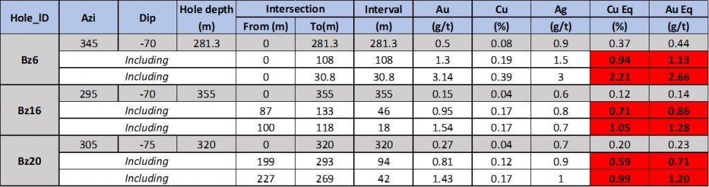
Notes: Copper Equivalent (“CuEq”) grades reported for the drill holes at Berezski East were calculated using the following formula: CuEq % = Copper (%) + (Gold (g/t) x 0.8264) + (Silver (g/t) x 0.0107). Gold Equivalent (“AuEq”) grades reported for the drill holes at Berezski were calculated using the following formula: AuEq g/t = Gold (g/t) + (Copper (%) x 1.2100) + (Silver (g/t) x 0.0129). Assumptions used for the copper and gold equivalent calculations were metal prices of US$3.00/lb. Copper, US$1,700/oz Gold, US$22/oz Silver, and metallurgical recoveries were assumed to be 90% for Cu and Au and 50% for Ag and Mo. Intervals are core-length and original core recovery is estimated to be > 90 %. Source: Arras Minerals
The above references an opinion and is for information purposes only. It is not intended to be investment advice. Seek a licensed professional for investment advice. The author is not an insider or shareholder of any of the companies mentioned above.
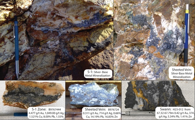
Blackwolf Copper and Gold (TSXV:BWCG) has announced results from its 2023 exploration programs at the Harry and Cantoo properties located in the prolific Golden Triangle region of British Columbia. The Cantoo property, situated 15 kilometres north of Hyder, Alaska and neighbouring the town of Stewart, BC, underwent its first-ever diamond drilling program this year. With 1,356 meters drilled in 3 holes, Blackwolf targeted the high-grade gold-silver-copper mineralization identified on surface that is related to the Jurassic-aged Premier porphyry intrusion.
Rob McLeod, Blackwolf’s Executive Chairman, commented in a press release: “Encountering Brucejack-style remobilized coarse electrum veins at Harry was the highlight of the 2023 program. Extensive multiphase sulphide-rich veining within a wide halo of strongly anomalous gold and silver is highly encouraging. Drilling in 2024 will target additional high-grade surface values and structural/geochemical traps located up dip from the high-grade veins. At Cantoo, geochemical vectoring and surface sampling are suggesting a northeast strike and steep dip to the wide veins; subsequent drilling will test this concept.”
Surface samples from Cantoo returned exceptional results including 29.2 g/t gold, 2,378 g/t silver, 4.35% copper and 7.24% zinc. The 2023 drilling intersected intense alteration zones bearing similarities to the nearby Premier deposit. The best drill intercept was 1.53 g/t gold over 1.5 meters in hole CT23-002. While significant precious metals values were not obtained, the results provide valuable insights into the structural geology at Cantoo, refining targeting for future drilling.
At the Harry property, located 30 kilometres north of Stewart, BC, Blackwolf conducted surface sampling and diamond drilling in 2023. A total of 99 surface grab samples and 1,741 meters of drilling in 7 holes were completed. The work defined two 1-kilometre-scale zones of intense quartz-sericite-pyrite alteration hosting lower-grade bulk-tonnage style gold mineralization. Surface samples returned up to 4.16 g/t gold and 9.71 g/t silver. Drilling intercepted a 150-meter trend of high-grade silver-lead-zinc veins at the Swann zone, including 0.47 g/t gold, 374 g/t silver, 5.34% lead and 1.41% zinc over 0.47 meters. The program also revealed potential for extensive high-grade gold mineralization related to the alteration halos, with a best drill intercept of 312 g/t gold and 101 g/t silver over 1 meter.
Blackwolf’s CEO, Morgan Lekstrom, also commented in the press release about the results: “Having successfully executed a program that stayed within budget, we have significantly expanded on previous results at the Harry Property, made a gold discovery, and gained a comprehensive understanding of the Cantoo Geology. This has led to a tremendous year for our initial drilling endeavors on both properties, and we are eager to build upon the discoveries at Harry and our newfound insights into the Cantoo Property. Mineralized occurrences at Harry have extended from the Swann Zone to several other mineralized occurrences across a 3-kilometer trend, adjacent to one of North America’s historically high-grade producers. Our company is fully funded to proceed with an extensive drill program on the Harry Property in 2024, and we have identified multiple areas where we anticipate further high-grade discoveries. With our enhanced understanding of Cantoo, we can now drill more efficiently and cost-effectively in pursuit of what we believe to be a significant new discovery. It’s important to remember that mines in the area are often discovered with over 100 drill holes, and with just 3 drill holes, we have obtained the information that uniquely positions us to expand our drilling at Cantoo and awaken this sleeping giant.”
The results from Cantoo and Harry have significantly advanced Blackwolf’s understanding of the geology and unveiled new high-grade precious and base metal discoveries. With numerous untested targets remaining, follow-up drilling and exploration work is being planned for 2024 to build on the insights gained during this first phase. Blackwolf is well positioned with its strategic foothold in the heart of the Golden Triangle to make further discoveries and unlock the potential of its portfolio.
Harry Property:
- Multiple Mineralization-Styles: Drilling and surface sampling have identified multiple mineralization styles, in all regions of the Property, particularly at the Swann Zone. Two major mineralization styles have been identified, including:
- The high-grade gold-silver veins contained in an extensive quartz-sericite-pyrite alteration package, as noted in surface sample 4.16 g/t Au and 9.71 g/t Ag, and subsequent in drilling 1.30 g/t Au and 2.90 g/t Ag over 2.0 meters and previously released results312 g/t Au and 101 g/t Ag, over 1.0 meter (refer to Blackwolf’s News release of October 30th, 2023).
- Multi-ounce silver base-metal veins with gold credits, as noted in surface sample 1,049 g/t Ag, 4.447 g/t Au, 1.521% Cu, 8.0% Pb, 1.55% Zn, and subsequent in drilling 374 g/t Ag, 5.34% Pb, 1.41% Zn over 0.47 meters.
- Multi-Zone Mineralization: The exploration effort has identified silver and base-metal occurrences, over a 3- kilometer trend, and two areas of intense quartz-sericite-pyrite alteration, each up to 1 kilometer in extent and associated with the previously released new high-grade visible gold vein discovery at the Swann Zone.
Cantoo Property:
- The surface exploration highlighted the high-grade mineralization with multiple scree samples from the mineralization above, as noted in samples 29.2 g/t Au, 2,378 g/t Ag, 4.345% Cu, 7.24% Zn, and 19.9 g/t Au and 7.92 g/t Ag.
- The initial drill program intersected porphyry-style alteration; strong zones of quartz-sericite alteration with sulphide mineralization. The strong mineralized alteration halos are analogue to the confirmed wide surface Cantoo vein mineralization outcropping in cliffs. The mineralization is closely associated with Jurassic-aged Texas Creek Intrusion suite as noted in mineralized interval in hole CT23-003 1.53 g/t Au and 1.01 g/t Au both over 1.5 metre. Further drilling to the southwest is needed to vector into high-grade shoots.
Table 1. Selected Surface Results from the 2023 Harry program
| Sample No. | Easting | Northing | Area | Au_ppm | Ag_ppm | Cu_% | Pb_% | Zn_% |
| B0017307 | 434380 | 6224629 | Harry | 1.001 | 57.72 | 0.010 | 1.650 | 0.116 |
| B976710 | 434366 | 6226621 | Harry | 1.346 | 4.45 | 0.003 | 0.049 | 0.025 |
| B976736 | 434150 | 6223754 | Harry | 1.07 | 11.38 | 0.003 | 0.325 | 0.069 |
| B976737 | 434141 | 6223695 | Harry | 4.16 | 9.71 | 0.003 | 0.083 | 0.021 |
| B976744 | 434122 | 6223527 | S-1 | 4.477 | 1049 | 1.521 | 8.000 | 1.550 |
| B976745 | 434118 | 6223566 | S-1 | 3.239 | 995 | 1.436 | 4.330 | 3.100 |
| B0012768 | 434023 | 6223880 | Saw Cut | 0.158 | 203 | 0.253 | 6.250 | 18.960 |
| B0012755 | 434054 | 6223721 | Sheeted Vein | 5.676 | 160 | 0.041 | 2.820 | 8.940 |
| B0012762 | 434045 | 6223642 | Sheeted Vein | 0.195 | 475 | 0.562 | 9.790 | 10.340 |
| B0012766 | 434032 | 6223680 | Sheeted Vein | 0.04 | 98.3 | 0.090 | 2.570 | 5.640 |
| B976717 | 434363 | 6226626 | Sheeted Vein | 0.077 | 3.72 | 0.103 | 0.017 | 1.290 |
| B976721 | 434165 | 6226380 | Sheeted Vein | 0.04 | 213 | 0.080 | 19.68 | 0.073 |
| B976724 | 434153 | 6226370 | Sheeted Vein | 0.311 | 714 | 0.663 | 14.190 | 16.830 |
| B0017303 | 434519 | 6224862 | Ursula | 0.86 | 92.03 | 0.049 | 3.610 | 4.910 |
| B0017305 | 434498 | 6224869 | Ursula | 1.756 | 21.68 | 0.016 | 0.524 | 0.234 |
| B0017306 | 434497 | 6224872 | Ursula | 1.083 | 11.02 | 0.006 | 0.082 | 0.016 |
Table 2. Swann Zone Drill hole Composites
| Hole-ID | Zone | From (meters) | To (meters) | *Length (meters) | Au (gpt) | Ag (gpt) | Pb (%) | Zn (%) | |
| H23-012 | Swann | 67.32 | 67.79 | 0.47 | 0.42 | 374.00 | 5.340 | 1.410 | |
| 118.10 | 118.89 | 0.79 | 1.62 | 2.79 | 0.014 | 0.001 | |||
| 160.00 | 161.00 | 1.00 | 0.46 | 14.77 | 0.265 | 2.470 | |||
| H23-013 | Swann | 55.00 | 55.50 | 0.50 | 0.15 | 12.08 | 1.30 | 0.2091 | |
| 93.00 | 96.10 | 3.10 | 0.33 | 13.05 | 0.057 | 0.127 | |||
| H23-014 | Swann | 66.00 | 67.00 | 1.00 | 0.07 | 1.09 | 0.019 | 0.267 | |
| 140.00 | 141.50 | 1.50 | 1.31 | 2.00 | 0.016 | 0.040 | |||
| 178.00 | 179.00 | 1.00 | 0.60 | 1.18 | 0.002 | 0.008 | |||
| H23-015 | Swann | 74.05 | 77.19 | 3.14 | 0.07 | 8.35 | 0.107 | 0.241 | |
| 191.42 | 192.45 | 1.03 | 0.68 | 1.27 | 0.009 | 0.012 | |||
| H23-016 | Swann | 223.00 | 224.00 | 1.00 | 2.01 | 4.00 | 0.010 | 0.002 | |
| H23-018 | Swann | 176.00 | 183.00 | 7.00 | 0.73 | 3.07 | 0.012 | 0.004 | |
| 176.00 | 193.00 | 17.00 | 0.41 | 5.97 | 0.004 | 0.08 | |||
| Inc. | 176.00 | 177.00 | 1.00 | 2.03 | 3.39 | 0.014 | 0.005 | ||
| Inc. | 181.00 | 183.00 | 2.00 | 1.30 | 2.895 | 0.014 | 0.005 |
* True widths are not known as there is not yet enough geological information.
Table 3. Selected Surface Assay Results from the 2023 Cantoo program
| Sample Number | Easting | Northing | Type | Au _ppm | Ag_ppm | Cu_% | Pb_% | Zn_% |
| B0011166 | 433890 | 6214868 | Float | 4.070 | 2.1 | 0.001 | 0.001 | 0.002 |
| B0011167 | 433880 | 6214859 | Float | 14.600 | 10.0 | 0.001 | 0.004 | 0.003 |
| B0011168 | 433801 | 6214830 | Float | 4.238 | 1.8 | 0.001 | 0.001 | 0.001 |
| B0011169 | 433801 | 6214830 | Float | 19.900 | 7.9 | 0.001 | 0.003 | 0.001 |
| B0011170 | 433773 | 6214845 | Float | 4.548 | 3.4 | 0.015 | 0.017 | 0.627 |
| B0011172 | 433807 | 6214839 | Float | 2.515 | 2.3 | 0.002 | 0.006 | 0.018 |
| B0011174 | 433889 | 6214870 | Float | 6.192 | 115.0 | 0.484 | 7.670 | 0.353 |
| B0011175 | 433001 | 6214866 | Float | 2.982 | 4.6 | 0.003 | 0.006 | 0.001 |
| B0011176 | 433912 | 6215138 | Float | 0.348 | 222.0 | 0.136 | 35.850 | 0.630 |
| B0011177 | 433919 | 6215145 | Float | 0.835 | 146.0 | 0.008 | 20.050 | 0.145 |
| B0011178 | 433919 | 6215168 | Float | 1.980 | 607.0 | 1.112 | 4.370 | 0.199 |
| B0011179 | 433919 | 6215168 | Float | 29.200 | 2378.00 | 4.350 | 0.527 | 7.240 |
| B0011301 | 433803 | 6214832 | Float | 4.482 | 2.1 | 0.000 | 0.001 | 0.000 |
| B0011302 | 433788 | 6214830 | Float | 9.903 | 6.4 | 0.001 | 0.003 | 0.004 |
| B0011303 | 433781 | 6214836 | Float | 5.582 | 1.8 | 0.000 | 0.001 | 0.001 |
| B0011304 | 433769 | 6214842 | Float | 5.720 | 2.4 | 0.001 | 0.001 | 0.000 |
| B0011305 | 433762 | 6214842 | Float | 7.005 | 3.4 | 0.002 | 0.002 | 0.001 |
Table 4. Cantoo drill hole Composites
| Hole-ID | From (meters) | To (meters) | *Length (meters) | Au (gpt) | Ag (gpt) | Cu (%) | Pb (%) | Zn (%) |
| CT23-001 | No Significant Results | |||||||
| CT23-002 | No Significant Results | |||||||
| CT23-003 | 433.00 | 434.50 | 1.50 | 1.53 | 5.58 | NC | NC | NC |
| 439.50 | 441.00 | 1.50 | 1.01 | 1.22 | NC | NC | NC | |
* True widths are not known as there is not yet enough geological information.
Table 5. Swann Zone Drill hole collar locations and orientations
| Hole-ID | Coordinate System | Easting | Northing | Elevation (m a.s.l) | Azimuth (Degrees) | Dip (Degrees) | Length (m a.s.l) |
| H23-012 | UTM_Zone9/NAD83 | 434390 | 6226542 | 890 | 215 | -50 | 249 |
| H23-013 | UTM_Zone9/NAD83 | 434390 | 6226542 | 890 | 240 | -50 | 250 |
| H23-014 | UTM_Zone9/NAD83 | 434390 | 6226542 | 890 | 230 | -60 | 250 |
| H23-015 | UTM_Zone9/NAD83 | 434390 | 6226542 | 890 | 215 | -60 | 251 |
| H23-016 | UTM_Zone9/NAD83 | 434312 | 6226610 | 862 | 215 | -50 | 242 |
| H23-017 | UTM_Zone9/NAD83 | 434312 | 6226610 | 862 | 230 | -50 | 246 |
| H23-018 | UTM_Zone9/NAD83 | 434312 | 6226610 | 862 | 250 | -50 | 251 |
Table 6. Cantoo drill hole collar locations and orientations
| Hole-ID | Coordinate System | Easting | Northing | Elevation (m a.s.l) | Azimuth (Degrees) | Dip (Degrees) | Length (m a.s.l) |
| *CT23-001 | UTM_Zone9/NAD83 | 433247 | 6214825 | 858 | 95 | -55 | 130.2 |
| CT23-002 | UTM_Zone9/NAD83 | 433244 | 6214839 | 860 | 95 | -55 | 676 |
| CT23-003 | UTM_Zone9/NAD83 | 433244 | 6214839 | 860 | 85 | -65 | 550 |
*Hole abandoned
The above references an opinion and is for information purposes only. It is not intended to be investment advice. Seek a licensed professional for investment advice. The author is not an insider or shareholder of any of the companies mentioned above.
Solaris Resources (TSX:SLS) (OTCQB:SLSSF) has announced the start of its 2024 drilling program at the Warintza copper-gold project in southeastern Ecuador. The company plans to have six drill rigs operating by the end of February as part of an aggressive exploration and resource expansion campaign this year.
The first drill rig has begun turning at the Warintza East zone, with a goal of significantly increasing the project’s mineral resource estimate. An updated estimate is expected in late Q2 2024, incorporating nearly double the previous meterage. Solaris aims to demonstrate major growth potential at the Warintza Central, East and Southeast zones within a common open pit shell.
Drilling will continue beyond the updated resource estimate, with a focus on further expanding mineralization and infill drilling covering at least 30 square kilometres. Additional permitted platform locations will enable optimized drill hole patterns. Some holes will serve the dual purpose of collecting data for metallurgical, geotechnical, and hydrogeological studies to support mine design.
Meanwhile, field exploration programs are underway to define new drill targets at prospective areas around the Warintza project. This includes follow-up sampling at the Mateo prospect, where previous soil sampling outlined a 3-kilometre by 1.4-kilometre copper-molybdenum anomaly surrounding a sandstone unit that may overlay a buried porphyry system.
On the financing side, Solaris has closed US$40 million in funding, including US$10 million in equity financing and the first US$30 million tranche of its previously announced US$80 million offtake debt facility. This financing package will support baseline exploration and development programs in 2024 and 2025.
Upon closing a recently announced C$130 million strategic investment by Zijin Mining Group Co. Ltd., Solaris plans to aggressively expand its drilling and exploration activities in 2024 and 2025. The company will aim to have ten drill rigs in operation and significantly increase regional exploration. Further details on infrastructure development and mine planning will follow in the coming months.
The above references an opinion and is for information purposes only. It is not intended to be investment advice. Seek a licensed professional for investment advice. The author is not an insider or shareholder of any of the companies mentioned above.
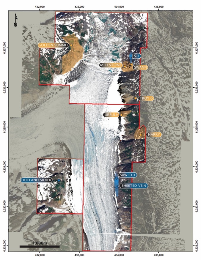
Gladiator Metals (TSXV:GLAD) has provided a comprehensive update on its ongoing drilling programs and exploration activities at the Whitehorse Copper Project located west of Whitehorse, Yukon, Canada. The company is targeting significant widths of unmined, high-grade copper-gold skarn mineralization along the historic Little Chief mine trend, which extends over 700 meters of strike length.
Gladiator CEO, Jason Bontempo commented in a press release: “Gladiator has commenced the first diamond drilling campaign at the Middle Chief Prospect since mine closure in 1982. The planned 10,000m diamond drilling is designed to test areas of high-grade copper skarn mineralization identified from its data compilation of historic drilling datasets at the Middle Chief target as well as near mine extensions to the historic Little Chief mine. These targets represent near surface areas of mineralization open in all directions with limited exploration or development away from historical underground infrastructure.”
The former Little Chief mining area was the largest historical producer in the Whitehorse Copper Belt, with approximately 8.54 million tons mined grading over 1.5% copper and 0.75g/t gold according to 1984 estimates by Watson. Production from the Little Chief open pit mine started in May 1967, with mining of the open pit completed by 1969. Underground mining development began in 1971 before operations ceased in 1982 due to low copper prices.
Gladiator’s review has identified excellent down-dip potential for the mineralization to continue in areas where limited or no drilling has been conducted to date. The mineralization remains open at depth and along strike from the historic Little Chief underground and open-cut mining operations.
Recent compilation of historic drilling data for the Little Chief mine has revealed a significant shallow mineralized zone measuring over 200 meters in length located only 120 meters below surface. This zone, named the Middle Chief target, appears to contain intact high-grade copper skarn mineralization based on the restricted extent of historical drilling. The compilation and 3D modelling of the Little Chief data is the first time the mineralization has been able to be visualized in three dimensions. This has provided Gladiator with clear open targets to potentially expand the known mineralization at Middle Chief and connect it to the historic Little Chief orebody which remains open in multiple directions.
Drilling commenced at Middle Chief on January 9, 2024 and will continue over the coming three months. The program consists of diamond core drilling with downhole electromagnetic (DHEM) surveys to identify extensions of the mineralization into untested areas. In contrast to selective historical sampling for only copper values, Gladiator will assay drill core and samples for a fuller range of credits including gold, silver and molybdenum.
The drill holes prefixed LCU-, D- and BC2 were collared from underground drives and declines providing access to the Little Chief mine workings. Therefore the reported downhole mineralized intercept depths do not represent true depths below surface.
At the Cowley Park copper-molybdenum skarn target, final assay results have now been received from Gladiator’s recently completed 4,000-meter diamond drill program. The results continue to demonstrate continuity of broad zones of shallow copper-molybdenum mineralization while also highlighting the potential for lower-grade envelopes to significantly expand the overall resource potential. The drilling confirms the width, grades and continuity of the previously targeted high-grade zones, with results including 15 meters at 2.36% copper and 13 meters at 2.06% copper.
The Cowley Park drill program was designed to test lateral extensions of known mineralization to aid planning of upcoming resource definition drilling. Most holes stepped out to the south and southeast of previous mineralization, such as hole 19-CP-08 which intersected 43.28m at 2.24% copper. A new zone of copper skarn was discovered 50 meters south of the main Cowley Park area, with an intercept of 10 meters at 1.23% copper. This illustrates the strong potential for further increasing the footprint of mineralization. The current drill-defined copper and molybdenum mineralization at Cowley Park remains open in all directions.
In addition to the extensive drilling, Gladiator is conducting a high-resolution drone airborne magnetic survey over the Little Chief mine trend. The survey data will be processed into a detailed 3D inversion model given the direct targeting potential of the magnetite-rich copper skarn mineralization.
Work to date, including assessment of early survey data, has identified over 30 regional drill-ready targets associated with copper-rich skarns along more than 35 kilometres of the contact between the Cretaceous Whitehorse Plutonic Suite and the older metasedimentary rocks of the Lewes River Group. This contact area is considered highly prospective but underexplored for further high grade copper +/- molybdenum +/- silver +/- gold mineralization.
The Whitehorse Copper Project encompasses the multiple past-producing skarn-hosted copper-gold deposits that occur along the deep-seated intrusive contact between the Whitehorse Plutonic Suite and Lewes River Group sediments. Gladiator is fully funded to continue its extensive drill programs and systematic exploration activities aimed at developing resources and expanding the known scope of copper-gold mineralization across its significant Whitehorse land package.
Highlights from the results are as follows:
- Gladiator plans to complete 10,000 metres of diamond drilling within the area, initially targeting Middle Chief, where a recent collation of historic data identified prospective unmined zones of mineralization, including:
- LCU-009: 49.83m @ 3.06% Cu from 70.26m
- LCU-017: 54.10m @ 2.05% Cu from 77.42m
- LCU-023: 33.99m @ 2.10% Cu from 148.89m, Incl. 15.24m @ 3.26%Cu
- LCU-503: 32.22m @ 2.11% Cu from 83.91m, Incl. 17.07m @ 3.47% Cu
- LCU-543: 13.72m @ 1.28% Cu from 66.14m and 41.15m @ 2.22% Cu from 87.48m
- LCU-610: 50.99m @ 1.87% Cu from 18.11m, Incl. 39.84m @ 2.19% Cu from 23.16m
- Drilling is planned to test:
- High grade copper skarn mineralization at Middle Chief that remains open in all directions. Unmined historic resources were established, and drilling completed just prior to the closure of the Little Chief mine in 1982, due to the prevailing low copper prices at the time.
- Compiled historical drilling data is limited to selective sampling and assaying for copper only. Gladiator intends to assay all future drilling and sampling for additional credits including Molybdenum, Silver and Gold which were proven contributors to the economics of historic operations.
| LCU-003: 53.56m @ 1.23% Cu from 88.54m LCU-009: 49.83m @ 3.06% Cu from 70.26m LCU-013 23.01m @ 2.07% Cu from 87.78m LCU-017: 54.10m @ 2.05% Cu from 77.42m LCU-023: 33.99m @ 2.10% Cu from 148.89m, Incl. 15.24m @ 3.26%Cu from 167.64m LCU-151: 32.92m @ 2.08% Cu from 86.87m LCU-371: 9.30m @ 4.73% Cu from 0m LCU-500: 22.52m @ 2.23% Cu from 79.86m LCU-503: 32.22m @ 2.11% Cu from 83.91m, LCU-528: 30.85m @ 1.68% Cu from 18.68m, LCU-542: 28.04m @ 1.84% Cu from 91.14m, |
LCU-543: 13.72m @ 1.28% Cu from 66.14m and 41.15m @ 2.22% Cu from 87.48m
LCU-550: 37.49m @ 1.90% Cu from 74.68m LCU-551: 24.9m @ 2.27% Cu from 93.97m LCU-571: 11.06m @ 3.79% Cu from 89.37m LCU-578; 30.17m @ 1.97% Cu from 31.09m LCU-580: 24.14m @ 1.86% Cu from 45.96m, LCU-604: 26.21m @ 1.86% Cu from 16.46m LCU-610: 50.99m @ 1.87% Cu from 18.11m, LCU-614: 38.22m @ 1.39% Cu from 10.24m, LCU-616: 37.79m @ 1.55% Cu from 21.34m, |
- CPG-017:
- 26m @ 1.49% Cu & 368 ppm Mo from 98m including 15m @ 2.36% Cu & 421ppm Mo from 104m and 4m @ 7.75% Cu & 686 ppm Mo from 110m.
- CPG-023:
- 13m @ 2.06% Cu and 1071 ppm Mo from 38m and
- 8m @ 1.05% Cu 513 ppm Mo from 79 m
- CPG-011D1:
- 58m @ 0.74% Cu & 1,245 ppm Mo from 81m, Including:
- 8m @ 1.65% Cu, 1,905 ppm Mo from 87m
- 12m @ 1.12% Cu & 605ppm Mo from 105m
- CPG-015:
- 17m @ 0.91% Cu from 42m, Incl. 3m @ 1.71 % Cu from 42m, 7m @ 1.45% Cu from 52m & 2m @ 3.77% Cu from 55m
- 31m @ 0.58% Cu, 642ppm Mo from 80m and
- 10m @ 1.23% Cu & 319ppm Mo from 204m
- CPG-016:
- 58m @ 0.62%Cu from 57m, Incl. 7m @ 1.99 % Cu & 867 ppm Mo from 78m
- CPG-019: 20m @ 0.82% Cu from 96m including 4m @ 2.62% Cu from 96m
- CPG-020D1: 47.2m @ 0.67% Cu from 132m
- CPG-026: 16m @ 1.06% Cu, 0.15ppm Au, 15.6 ppm Ag, and 487 ppm Mo from 106m
The above references an opinion and is for information purposes only. It is not intended to be investment advice. Seek a licensed professional for investment advice. The author is not an insider or shareholder of any of the companies mentioned above.
Carlyle Commodities (CSE:CCC) has completed a new diamond drill program at the Newton Gold Project located in British Columbia, Canada. The drill program totalled 840.3 metres across 7 drill holes and tested multiple high-priority targets with the goal of expanding the current mineral resource estimate.
Morgan Good, President and Chief Executive Officer, commented in a press release: “We are very pleased with this efficient 7-hole drill program and the professional work of our team. All holes successfully intersected our primary targets. We look forward to our results and continuing to advance the Newton project in 2024.”
Jeremy Hanson, VP of Exploration, also commented: “We are excited about the holes we completed, there was a lot of productive activity completed in a short time frame. The drill team tested a variety of high-potential targets where much of the core contained strongly altered rocks, disseminated and veined sulphides. We are certainly looking forward to our results and getting back on the ground.”
The Newton Gold Project contains an inferred mineral resource estimate dated June 13, 2022 of 861,400 ounces of gold and 4,678,000 ounces of silver at an average grade of 0.63 g/t gold using a 0.25 g/t gold cut-off grade across 42,396,600 tonnes.
The targets for the latest 7-hole drill program included surface geochemical anomalies, open mineralization from previous drilling, and mineralized volcanic and intrusive rocks. The intention was to potentially expand the existing inferred resource, identify new zones of mineralization, and test for higher-grade mineralization near surface.
All drill holes successfully intersected altered and mineralized lithologies including felsic and mafic volcanic rocks and quartz porphyry intrusions which host the gold mineralization at Newton. Sulphide minerals were also intersected which are commonly associated with gold mineralization at the project.
The Newton Gold deposit remains open in multiple directions with room to expand the resource size and grade. The current resource occupies just 7% of a broad induced polarization anomaly that measures the sulphide content of rocks. Areas for immediate follow-up include south and southwest of the current resource where previous drilling has intersected mineralized volcanics that are not part of the current resource. Extensions of the mineralization are also open down dip to the southwest.
The majority of the large sulphide-bearing altered area defined by historically induced polarization surveys remains underexplored. Previous limited drilling beyond the area of densest drilling to the northwest returned significant gold intersections indicating potential for additional resources.
All drill core samples have been sent to Bureau Veritas laboratories for analysis and assay results are expected within weeks. Once received the results will be incorporated into planning the next phase of exploration and drilling at the Newton Gold Project.
Highlights from the program are as follows:
- The Newton Gold Project is a large, bulk tonnage, low – to intermediate-sulphidation, epithermal gold deposit with nearly 35,000 m of drilling exploring and developing the historical resource, primarily between 2009-2012.
- Updated pit-constrained inferred mineral resource contains 861,400 oz of Au, and 4,678,000 oz of Ag with an average grade of 0.63 g/t Au, a cut off of 0.25 g/t Au throughout 42,396,600 tonnes.
- The Newton Gold Project encompasses more than 24,000 ha.
- The Updated Newton Resource Calculation occurs within an 800 x 400 m area defined by drilling to depths of approximately 500 m with majority of the holes not exceeding 300 m depth.
- Underlying the deposit, a large IP anomaly measures 4 km x 2 km and covers an area greater than 7 km2 – yet the existing inferred mineral resource occupies slightly over 0.5 km2 or just 7% of the anomaly.
- Gold and associated base metal mineralization precipitated in extensive zones of strong quartz-sericite alteration as well as in mafic volcanic and clastic sedimentary rocks and along fault and fracture zones.
- The alteration assemblages and metal associations at the Newton Gold Project are similar to the Blackwater gold project deposit of Artemis Gold Inc. (“Artemis“). The Blackwater gold project, which is in construction phase, is located approximately 185 km northeast of Newton, where it is one of Canada’s largest open-pitable gold deposits and one of the world’s largest environmental assessment approved gold development projects. Blackwater has a measured + indicated resource estimated at 11.7 million ounces Au and 122 million ounces of Ag.
Table 1 – Drill collar table
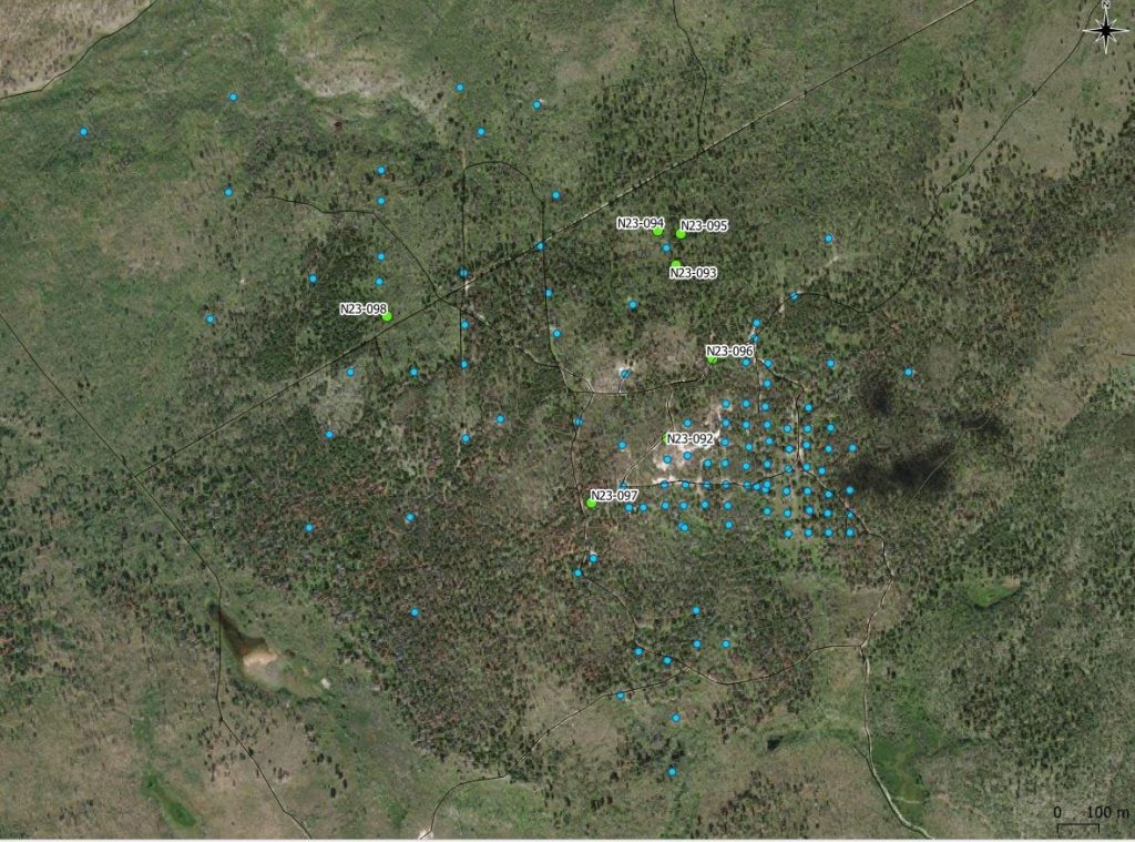
| Hole_ID | Easting | Northing | Elevation | Azimuth | Dip | Depth |
| N23-092 | 457108 | 5738816 | 1321 | 0 | -90 | 258 |
| N23-093 | 457130 | 5739235 | 1324 | 0 | -90 | 105 |
| N23-094 | 457086 | 5739318 | 1307 | 0 | -90 | 109 |
| N23-095 | 457142 | 5739312 | 1310 | 0 | -90 | 92 |
| N23-096 | 457218 | 5739009 | 1333 | 0 | -90 | 87 |
| N23-097 | 456925 | 5738660 | 1291 | 0 | -50 | 135 |
| N23-098 | 456430 | 5739111 | 1276 | 0 | -90 | 54 |
Hole N23-092
Hole N23-092 was drilled 50 metres north of hole 10016 where the inferred mineral resource remains open to the northwest along a broad corridor. The hole was drilled to a depth of 258 m and intersected strongly altered quartz feldspar porphyries intruding altered felsic volcanic rocks with disseminated and fracture-controlled pyrite.
Holes N23-093, N23-094, and N23-095
Holes N23-093, 94, and 95 were drilled approximately 350 – 450m north of the NI 43-101 inferred mineral resource boundary, around historical hole 10030. Hole 10030 intersected 24 metres of 0.83 g/t Au from 18.0 – 42.0 metres in propylitic altered mafic volcanics associated with an IP chargeability anomaly. As such, this area represents a potential higher grade near surface area of significant interest.
The Company drilled three holes around hole 10030, triangulating 50m step outs to the northeast, southwest, and northwest of this hole to investigate possible continuation of this mineralization. These holes were also plotted based on gold-in-soil geochemical anomalies and elevated IP chargeability anomalies proximal to hole 10030. All three holes intersected propylitic altered mafic volcanics with disseminated and fracture-controlled sulphides from surface to the approximate total depth of 100m in each hole.
Hole N23-096
Hole N23-096 was drilled more than 100 meters north of the inferred mineral resource where historic trenching, rock and soil sampling all returned significant gold values at surface. The hole was drilled to 87 metres and intersected very strongly altered felsic volcanics with disseminated and fracture-controlled sulphides to a depth of 24 metres. The hole cut altered mafic volcanics from 24 to the total length of 87 metres, including small metre scale felsic intrusive.
Hole N23-097
Hole N23-097 was drilled immediately west of the inferred mineral resource where mineralization is open and begins at surface, demonstrated in historic trenching and drilling. The hole was drilled to a depth of 135 metres and intersected strongly altered quartz feldspar porphyry with disseminated and fracture-controlled sulphides as pyrite – chalcopyrite ± sphalerite veinlets.
Hole N23-098
Hole N23-098 was drilled 750 meters northwest of the inferred mineral resource targeting a gold-in-soil geochemical anomaly proximal to historic drill holes that intersected felsic volcanics and quartz feldspar porphyry. This hole was drilled to 54.0 metres and intersected altered quartz feldspar porphyry with disseminate and vein hosted pyrite.
The above references an opinion and is for information purposes only. It is not intended to be investment advice. Seek a licensed professional for investment advice. The author is not an insider or shareholder of any of the companies mentioned above.
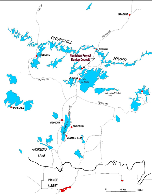
Arya Resources (TSXV:RBZ) has completed the first phase of exploratory drilling at its Dunlop nickel-copper project located approximately 45 km north of La Ronge. The drilling program, conducted between December 7-17, 2023, consisted of 8 drill holes totaling 1,045 meters.
The company focused drilling on targets identified at the East Zone of the historic Dunlop deposit. Visual inspection of the drill core indicates the presence of nickel and copper sulfide mineralization similar to that found in previous exploration campaigns between 1960-1980. The core is being processed at a facility in La Ronge before being sent to SRC Labs in Saskatoon for assay analysis.
Previous work outlined a historical resource of 18.11 million tonnes containing nickel, copper, chromium and cobalt. Approximately 12.83 million tonnes were considered viable for open pit mining with the remainder suitable for underground extraction. Historical grades ranged from 0.55% to 1.46% nickel and 0.15% to 0.39% copper.
Arya Resources is a mining and exploration company focused on critical minerals including gold, uranium, lithium and rare earth elements. The company’s shares trade on the TSX Venture Exchange under the symbol RBZ.
The Dunlop project is accessible via provincial highways and power infrastructure. Arya states it has obtained all necessary permits for exploration drilling. Assay results from the recent drill program are still pending.
Highlights from the program are as follows:
Table 1: Fall 2023 Drill Program; Dunlop Ni-Cu Project, Nemeiben Lake
| Hole # | UTM E | UTM N | Elevation (m) |
Az TN | Dip | Final Depth (m) |
| AR23-001 | 489275 | 6130814 | 400.9 | 0.0 | -50 | 200.0 |
| AR23-002 | 489275 | 6130867 | 396.7 | 0.0 | -50 | 155.0 |
| AR23-003 | 489222 | 6130867 | 397.1 | 0.0 | -55 | 164.0 |
| AR23-004 | 489325 | 6130845 | 395.6 | 0.0 | -50 | 140.0 |
| AR23-005 | 489325 | 6130900 | 390.5 | 0.0 | -50 | 119.0 |
| AR23-006 | 489225 | 6130918 | 390.4 | 0.0 | -55 | 125.0 |
| AR23-007 | 489275 | 6130945 | 390.7 | 0.0 | -55 | 65.0 |
| AR23-008 | 489275 | 6130945 | 390.7 | 0.0 | -70 | 74.0 |
Kevin Wells, P.Geo, a consulting geologist to the Company, is the independent qualified person as defined by National Instrument 43-101 – Standards of Disclosure for Mineral Projects for the technical disclosure contained in this news release.
The above references an opinion and is for information purposes only. It is not intended to be investment advice. Seek a licensed professional for investment advice. The author is not an insider or shareholder of any of the companies mentioned above.
![]()
Canadian junior exploration company Great Pacific Gold (TSXV:GPAC) recently announced exciting results from drilling at its Lauriston gold project located in the state of Victoria, Australia.
A reverse circulation (RC) drill hole at the Comet prospect intersected a high-grade zone of gold mineralization. Drill hole CRC07 returned an intercept of 5 meters grading 166 grams per tonne (g/t) gold from 95 meters depth. This includes an even higher grade interval of 2 meters at 413 g/t gold. Within this zone, assays returned 1 meter at 468 g/t gold and 1 meter at 358 g/t gold.
According to Great Pacific’s announcement, follow-up sampling was conducted on the alteration halo surrounding the high-grade mineralized zone. It was expected that this halo might return anomalous but sub-economic gold values. However, assays surprised by returning an interval of 1-meter grading 13 g/t gold.
With these new halo assays, the total mineralized interval from 95 meters depth has now expanded to 8 meters grading 106 g/t gold. This includes the previously announced high-grade section of 5 meters at 166 g/t gold, which contains the bonanza grades of 413 g/t over 2 meters.
The Comet prospect where this discovery was made exhibits geological characteristics typical of epizonal orogenic gold deposits. The style of mineralization and minerals present – gold-arsenic-antimony – is similar to the extremely high-grade Fosterville mine owned by Kirkland Lake Gold, located elsewhere in Victoria.
At Comet, mineralization occurs within the Comet fault zone, which trends westward and dips steeply. This structure cuts Ordovician-aged slate and sandstone units that display folding into a series of north-south striking concertina shapes. The high-grade gold discovery hole is situated close to the Comet anticline fold structure that has been mapped at surface in the project area. This anticline is considered important in controlling the localization of gold within the fault zone.
The structural setting at Comet bears many similarities to the depositional environment of Fosterville’s exceptional gold endowment. Much anticipation will await drill testing of this new discovery at depth and along trend.
Great Pacific states that a diamond drill rig is being mobilized to site to follow up this discovery made by RC drilling. Diamond drilling is slated to resume at the Comet prospect in late January or early February 2022. Diamond drilling will allow for more detailed sampling and analysis of the high-grade structure.
In other company news, Great Pacific announced the appointment of Dr. Chris Muller to its Board of Directors, replacing John Lewins who will continue serving in an advisory role.
Dr. Muller brings over 20 years of exploration experience to Great Pacific, from work spanning diverse geological environments in Papua New Guinea, Mongolia, China, Ghana, Indonesia and Thailand. He currently serves as Executive Vice President, Exploration for K92 Mining, a rapidly growing gold producer in Papua New Guinea.
Some career highlights for Muller include involvement in discovery of additional porphyry deposits at the world-class Wafi-Golpu project in PNG, and recognition of the Blue Lake porphyry deposit which is now PNG’s 5th largest.
At K92, Chris Muller and his exploration team were recently awarded the Thayer Lindsley Award from the Prospectors & Developers Association of Canada for the Kora North discovery, judged the best global mineral discovery of 2021.
Great Pacific also announced it has granted 6,690,000 restricted share units and 2,215,000 incentive stock options in conjunction with new appointments, including Muller to the board. The options are exercisable at $0.95 per share for a five-year term from the grant date.
With positive early drilling results from the Lauriston project and the strengthening of its exploration leadership, Great Pacific Gold appears poised for an active 2022 further testing its Australian gold properties. The company will be one to watch as this recent high-grade discovery is followed up.
| HoleID | East | North | Azimuth (deg.) |
Dip (deg.) | From (m) | To (m) | Downhole Interval (m) |
Au g/t |
| CRC007 | 263517 | 5850093 | 92 | -66 | 95 | 103 | 8 | 106 |
| includes | 95 | 100 | 5 | 166 | ||||
| includes | 96 | 98 | 2 | 413 |
The 8m intercept uses a 0.6 g/t Au cut-off grade and no internal waste. The 5m intercept uses a 1.0 g/t Au cut-off grade and no internal waste, while the higher-grade included intercept of 2m uses assays of greater than 350 g/t Au and no internal waste parameter. True widths are not known. Additional drilling is required to determine true widths. The assays are not capped.
The above references an opinion and is for information purposes only. It is not intended to be investment advice. Seek a licensed professional for investment advice. The author is not an insider or shareholder of any of the companies mentioned above.
Eloro Resources (TSX:ELO) has announced the final assay results from an 11-hole, 5,267.7-meter definition drill program at its Iska Iska silver-tin polymetallic project in southwestern Bolivia.
Tom Larsen, CEO of Eloro commented in a press release: “I am very pleased with the continuation of significantly higher-grade silver equivalent results from the latest definition drilling program, compared to the initial mineral resource estimate (“MRE”) starter pit area model as previously reported (see Eloro press release dated Oct 17, 2023). These new results highlight the potential to upgrade and expand the higher-grade resource in the Santa Barbara starter pit area. Tin is proving to be an important metal contributor to these upgraded silver equivalent results. This can enhance NSR values and increase tonnage in future MRE studies. As an example, Hole DSB-63 located in the Northeast section of the Santa Barbara starter pit area, recognized more as a Polymetallic (Ag-Zn-Pb) Domain, returned 0.51% tin over a 23.02-meter drill intercept with a total silver equivalent value of 205.57 g/t. There is more and more evidence of high temperature sulphidation centres being identified as feeders within the open pit area resulting in upgraded tin and silver values. Higher density definition drilling in the initial Santa Barbara open pit envelope is consistently proving up higher grades as drill density is improved.”
The drill program focused on upgrading and expanding the project’s higher-grade polymetallic inferred mineral resource, which contains an estimated 132 million tonnes grading 24.3 g/t silver, 1.11% zinc and 0.50% lead. This equates to 72.06 g/t silver equivalent at a net smelter return (NSR) cutoff of $25 per tonne. The net NSR value of this resource is $34.40 per tonne, which is 3.75 times the estimated operating cost of $9.20 per tonne.
Several holes also tested the adjacent tin-silver-lead domain, where high silver values have previously been obtained along with tin. Drill hole locations targeted areas to upgrade and expand the higher-grade zone along and across strike near the potential starter pit area.
Assay results confirm the drill program has expanded the higher-grade tin and silver zones, especially to the west where little previous drilling has occurred. This highlights the potential to expand the current mineral resource, particularly for tin.
Initially, the preliminary economic assessment planned for Iska Iska was to focus solely on the polymetallic resource, with tin as a major exploration target. However, the new drill results suggest potential to significantly expand the higher-grade tin resource west of the potential pit and incorporate it into the preliminary economic assessment.
The technical report for Iska Iska’s initial mineral resource estimate noted higher-grade areas are also the most thoroughly drilled. Improving drill density across the deposit could increase grades due to better sample density, which recent results suggest is likely.
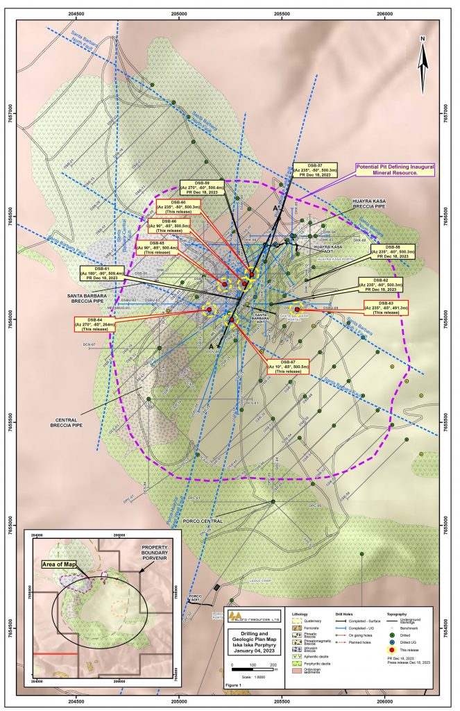
Dr. Osvaldo Arce, P.Geo. General Manager of Eloro’s Bolivian subsidiary Minera Tupiza S.R.L. and an expert on Bolivian mineral deposits also commented in the press release: “The definition drilling is confirming a strong high-grade Ag-Sn association, which is common in the southern Bolivian Tin Belt, including in large systems at Cerro Rico de Potosi, Animas-Siete Suyos-Chocaya and Tatasi deposits that occur along NW-SE striking structural corridors, the same geological environment that is present at Iska Iska. Recent drilling results have outlined upgraded tin and silver values from near surface down to at least 500m in vertical extent, principally in the sulphide zone. Geophysical information and deep drilling indicate that tin-silver mineralization may extend to depths of 1km or more. Tin mineralization in these zones has been remobilized and redeposited throughout the deposit by brecciation in favorable rock types, especially medium grained porphyritic dacite and intrusion breccia which are the most widespread lithologies at Iska Iska. Moreover, tin-polymetallic mineralization can be locally extensive/continuous as occurs in hole DSB-67, where 477m of the 500m drilled averages about 0.1% Sn, with almost no waste material. This high-grade continuous polymetallic mineralization forms commonly subhorizontal vein-parallel banding along north-northwest trending shear zones, indicating multiple episodes of fracture opening and mineral precipitation.”
Highlights from the results are as follows:
- Hole DSB-66 above also returned other well mineralized intersections including:
- 24.67g Ag/t, 1.08% Zn, 0.83% Pb and 0.08% Sn (94.46g Ag eq/t) over 86.39m, and
- 7.46g Ag/t, 2.51% Zn, 1.02% Pb and 0.06% Sn (129.90g Ag eq/t) over 74.85m
- Hole DSB-65 intersected 118.86g Ag/t*, 0.35% Zn, 0.35% Pb and 0.15% Sn (152.29g Ag eq/t*) over 81.28m including a very high-grade sample of:
- 5,080g Ag/t, 0.12 g Au/t, 0.26% Zn, 1.34% Pb, 1.53% Cu and 1.27% Sn (4,746.46g Ag eq/t) over 1.46m
- This very high-grade sample highlights the potential for Iska Iska to host extraordinary grades within the overall extensive mineralized system.
- Hole DSB-63, the eastern most hole in the definition drill program, intersected a significant Sn intersection of 23.37 g Ag/t, 1.77% Zn. 1.22% Pb and 0.51% Sn (205.57g Ag eq/t) over 23.02m. This area is in the Polymetallic (Ag-Zn-Pb) Domain where Sn values have typically been low. This suggests potential to extend the higher-grade Sn zone further east.
- The definition drill program has expanded both the higher-grade Sn and Ag zones especially to the west where there has been only limited previous drilling. These new data highlight the potential to upgrade and expand the mineral resource particularly by outlining a significant higher-grade Sn resource to include for consideration in the preliminary economic assessment (“PEA”).
Hole DSB-66 intersected several long well mineralized intervals as follows:
- 57.62g Ag/t, 1.26% Zn, 0.94% Pb and 0.12% Sn (139.94g Ag eq/t) over 136.11m from 137.75m to 273.86m including:
- 136.81g Ag/t, 2.00% Zn, 1.38% Pb and 0.17% Sn (255.19g Ag eq/t) over 34.77m from 187.64m to 222.41m
- 24.67g Ag/t, 1.08% Zn, 0.83% Pb and 0.08% Sn (94.46g Ag eq/t) over 86.39m from 288.92m to 375.31m including:
- 69.37g Ag/t, 0.41g Au/t, 1.88% Zn, 3.68% Pb and 0.32% Sn (272.27g Ag eq/t) over 6.08m from 307.15m to 313.23m,
- 23.59g Ag/t, 2.14% Zn, 1.57% Pb and 0.15% Sn (159.64g Ag eq/t) over 6.15m from 328.23m to 334.38m, and
- 99.40g Ag/t, 1.60% Zn, 1.06% Pb and 0.10% Sn (187.52g Ag eq/t) over 12.24m from 360.02m to 372.26m
- 7.46g Ag/t, 2.51% Zn, 1.02% Pb and 0.06% Sn (129.90g Ag eq/t) over 74.85m from 415.85m to 490.70m
- 10.80g Ag/t, 0.12 g Au/t, 4.96% Zn, 1.49% Pb and 0.06% Sn (229.62g Ag eq/t) over 16.86m from 430.99m to 447.85m
- 13.86g Ag/t, 4.20% Zn, 2.35% Pb and 0.34% Sn(277.75g Ag eq/t) over 7.76m from 457.31m to 465.07m
Hole DSB-65 collared 100m west of hole DSB-66 intersected the highest-grade silver sample intersected thus far at Iska Iska in an 80+m wide well mineralized zone as follows:
- 118.86g Ag/t, 0.35% Zn, 0.35% Pb and 0.15% Sn (152.29g Ag eq/t) over 81.28m from 353.49m to 434.77m including:
- 5,080g Ag/t, 0.12 g Au/t, 0.26% Zn, 1.34% Pb, 1.53% Cu and 1.27% Sn (4,746.46g Ag eq/t) over 1.46m from 362.53m to 363.99m
- Cutting of this very high Ag sample to 1,000g Ag/t based on a statistical probability plot yields a still high average for the 81.28m interval of 45.58 g Ag/t with an overall grade of 87.80 g Ag eq/t
- This very high-grade sample highlights the potential for Iska Iska to host extraordinary grades within the overall extensive mineralized system.
Hole DSB-67 collared 200m south-southwest of DSB-66 intersected a wide zone of mineralization grading 8.17 g Ag/t, 1.40% Zn, 0.48% Pb and 0.06% Sn (79.08g Ag eq/t) over 236.13m from 240.04m to 476.17m including higher grade zones of:
- 2.17g Ag/t, 0.16 g Au/t, 2.65% Zn, 0.52% Pb and 0.06% Sn (118.18g Ag eq/t) over 9.03m from 249.09m to 258.12m and
- 28.10g Ag/t, 4.25% Zn, 1.67% Pb and 0.17% Sn (245.05g Ag eq/t) over 19.45m from 434.06m to 453.51m
Hole DSB-60 intersected a 158.58m long zone of lower grade mineralization with higher-grade zones as follows:
- 16g Ag/t, 0.66% Zn, 0.41% Pb and 0.09% Sn (63.23g Ag eq/t) over 158.58m from 15.33m to 173.91m including:
- 23.31g Ag/t, 1.18% Zn, 0.56% Pb and 0.16%Sn (105.56 g Ag eq/t) over 6.16m from 34.99m to 41.15m and
- 115.54g Ag/t, 1.45% Zn and 1.67% Pb (201.17g Ag eq/t) over 4.54m from 139.32m to 143.86m
Hole DSB-63, the eastern most hole in the definition drill program, intersected a significant Sn intersection of 23.37 g Ag/t, 1.77% Zn. 1.22% Pb and 0.51% Sn (205.57g Ag eq/t) over 23.02m from 446.10m to 469.12m. This area is in the Polymetallic (Ag-Zn-Pb) Domain where Sn values have typically been low. This suggests potential to extend the higher-grade Sn zone further east.
Hole DSB-64, the southwestern most hole in the definition drill program, intersected 113.33g Ag/t and 0.12 g Au/t (110.97 g Ag eq/t) over 22.91m from 35.22m to 58.13m and 172.37 g Ag/t and 0.17% Pb% (161.78g Ag eq/t) over 13.46m from 135.83m to 149.29m. This hole was terminated at 240m due to faulting short of its planned depth of 500m.
| Table 1: Diamond Drill Results as of January 11, 2024, Santa Barbara Deposit, Iska, Iska |
||||||||||
| SANTA BARBARA DEFINITION DRILLING | ||||||||||
| Hole No. | From (m) | To (m) | Length (m) | Ag | Au | Zn | Pb | Cu | Sn | Ag eq |
| g/t | g/t | % | % | % | % | g/t | ||||
| DSB-60 | 15.33 | 173.91 | 158.58 | 16.00 | 0.04 | 0.66 | 0.41 | 0.03 | 0.09 | 63.23 |
| Incl. | 34.99 | 41.15 | 6.16 | 23.31 | 0.05 | 1.18 | 0.56 | 0.05 | 0.16 | 105.56 |
| Incl. | 56.29 | 65.40 | 9.11 | 12.95 | 0.04 | 0.95 | 0.57 | 0.02 | 0.24 | 103.35 |
| Incl. | 139.32 | 143.86 | 4.54 | 115.54 | 0.04 | 1.45 | 1.67 | 0.02 | 0.05 | 201.17 |
| 178.30 | 179.91 | 1.61 | 20.90 | 0.04 | 0.05 | 0.16 | 0.33 | 0.27 | 74.56 | |
| 184.41 | 185.96 | 1.55 | 41.00 | 0.23 | 0.09 | 0.04 | 0.31 | 0.24 | 84.44 | |
| 196.56 | 211.64 | 15.08 | 13.66 | 0.05 | 0.01 | 0.02 | 0.12 | 0.34 | 76.21 | |
| 217.59 | 223.68 | 6.09 | 15.22 | 0.03 | 0.93 | 0.02 | 0.01 | 0.19 | 81.42 | |
| 228.13 | 229.67 | 1.54 | 8.40 | 0.02 | 1.09 | 0.13 | 0.02 | 0.06 | 60.78 | |
| 240.25 | 243.25 | 3.00 | 53.30 | 0.14 | 0.18 | 0.01 | 0.08 | 0.08 | 68.41 | |
| 258.30 | 259.77 | 1.47 | 56.20 | 0.13 | 0.01 | 0.06 | 0.06 | 0.10 | 69.24 | |
| 265.84 | 268.83 | 2.99 | 56.23 | 0.03 | 0.07 | 0.09 | 0.12 | 0.11 | 74.36 | |
| 280.84 | 286.97 | 6.13 | 139.57 | 0.03 | 0.07 | 0.25 | 0.12 | 0.02 | 134.78 | |
| 302.01 | 306.51 | 4.50 | 135.36 | 0.03 | 0.18 | 0.17 | 0.11 | 0.24 | 174.44 | |
| 315.62 | 336.69 | 21.07 | 15.95 | 0.03 | 0.33 | 0.42 | 0.02 | 0.21 | 75.11 | |
| 353.25 | 359.30 | 6.05 | 77.11 | 0.35 | 0.24 | 0.32 | 0.26 | 0.44 | 165.36 | |
| 371.34 | 375.78 | 4.44 | 61.40 | 0.06 | 0.06 | 0.04 | 0.31 | 0.27 | 106.97 | |
| 458.92 | 463.72 | 4.80 | 25.11 | 0.05 | 0.03 | 0.01 | 0.07 | 0.18 | 56.96 | |
| 468.20 | 471.30 | 3.10 | 8.20 | 0.11 | 0.03 | 0.02 | 0.19 | 0.33 | 70.19 | |
| 474.34 | 475.91 | 1.57 | 4.80 | 0.16 | 0.04 | 0.02 | 0.56 | 1.06 | 202.69 | |
| DSB-63 | 33.75 | 35.25 | 1.50 | 5.60 | 0.01 | 0.01 | 3.38 | 0.00 | 0.12 | 105.60 |
| 67.09 | 79.28 | 12.19 | 5.15 | 0.01 | 0.84 | 0.63 | 0.01 | 0.01 | 50.68 | |
| 83.82 | 88.41 | 4.59 | 13.22 | 0.02 | 1.68 | 0.50 | 0.01 | 0.02 | 85.89 | |
| 97.49 | 103.51 | 6.02 | 7.13 | 0.01 | 0.94 | 0.27 | 0.00 | 0.01 | 47.54 | |
| 117.06 | 129.16 | 12.10 | 14.85 | 0.02 | 1.23 | 0.59 | 0.01 | 0.02 | 73.77 | |
| 197.04 | 219.80 | 22.76 | 8.30 | 0.09 | 1.32 | 0.39 | 0.02 | 0.01 | 65.18 | |
| 228.98 | 239.60 | 10.62 | 3.49 | 0.12 | 1.09 | 0.26 | 0.01 | 0.01 | 49.07 | |
| 257.63 | 260.56 | 2.93 | 6.82 | 0.05 | 1.68 | 0.34 | 0.00 | 0.01 | 74.06 | |
| 331.33 | 332.85 | 1.52 | 4.70 | 0.01 | 1.65 | 0.30 | 0.01 | 0.01 | 70.84 | |
| 344.91 | 346.43 | 1.52 | 7.40 | 0.64 | 1.85 | 0.29 | 0.02 | 0.01 | 79.75 | |
| 446.10 | 469.12 | 23.02 | 23.37 | 0.08 | 1.77 | 1.22 | 0.01 | 0.51 | 205.57 | |
| DSB-64 | 35.22 | 58.13 | 22.91 | 113.33 | 0.12 | 0.00 | 0.08 | 0.00 | 0.05 | 110.97 |
| 135.83 | 149.29 | 13.46 | 172.37 | 0.03 | 0.00 | 0.17 | 0.01 | 0.03 | 161.78 | |
| 159.89 | 167.39 | 7.50 | 75.91 | 0.06 | 0.00 | 0.17 | 0.01 | 0.10 | 88.68 | |
| 177.98 | 191.38 | 13.40 | 5.22 | 0.06 | 0.00 | 0.04 | 0.00 | 0.37 | 74.68 | |
| 209.43 | 212.34 | 2.91 | 7.31 | 0.04 | 0.00 | 0.01 | 0.00 | 0.55 | 109.77 | |
| 255.80 | 264.00 | 8.20 | 5.91 | 0.25 | 0.00 | 0.03 | 0.00 | 0.37 | 75.08 | |
Table 1 (con’t)
| Hole No. | From (m) | To (m) | Length (m) | Ag | Au | Zn | Pb | Cu | Sn | Ag eq |
| g/t | g/t | % | % | % | % | g/t | ||||
| DSB-65 | 17.95 | 22.46 | 4.51 | 190.56 | 0.16 | 0.00 | 0.06 | 0.00 | 0.22 | 210.39 |
| 74.18 | 108.83 | 34.65 | 36.45 | 0.01 | 0.35 | 0.03 | 0.08 | 0.05 | 54.09 | |
| 119.38 | 143.30 | 23.92 | 15.92 | 0.02 | 1.03 | 0.18 | 0.06 | 0.09 | 70.40 | |
| 167.56 | 173.57 | 6.01 | 6.01 | 0.01 | 1.04 | 0.16 | 0.02 | 0.04 | 53.72 | |
| 188.68 | 191.66 | 2.98 | 5.01 | 0.01 | 0.19 | 0.00 | 0.02 | 0.25 | 57.12 | |
| 211.21 | 212.67 | 1.46 | 5.00 | 0.01 | 0.66 | 0.05 | 0.01 | 0.62 | 143.90 | |
| 229.00 | 230.49 | 1.49 | 2.00 | 0.13 | 0.01 | 0.01 | 0.01 | 0.72 | 135.92 | |
| 244.25 | 245.78 | 1.53 | 45.00 | 0.02 | 0.04 | 0.01 | 0.19 | 0.14 | 67.42 | |
| 256.27 | 257.86 | 1.59 | 18.00 | 0.06 | 0.03 | 0.04 | 0.22 | 0.21 | 57.11 | |
| 268.44 | 274.47 | 6.03 | 4.45 | 0.04 | 0.04 | 0.03 | 0.00 | 0.28 | 58.54 | |
| 289.59 | 291.11 | 1.52 | 4.00 | 0.01 | 0.34 | 0.01 | 0.01 | 0.23 | 58.20 | |
| 294.19 | 306.70 | 12.51 | 68.35 | 0.10 | 0.02 | 0.04 | 0.17 | 0.18 | 94.41 | |
| 314.23 | 327.86 | 13.63 | 67.04 | 0.07 | 0.12 | 0.05 | 0.08 | 0.08 | 79.03 | |
| * | 353.49 | 434.77 | 81.28 | 118.86 | 0.03 | 0.35 | 0.35 | 0.05 | 0.15 | 152.29 |
| *Incl. | 362.53 | 363.99 | 1.46 | 5080.00 | 0.12 | 0.26 | 1.34 | 1.53 | 1.27 | 4746.46 |
| 445.27 | 500.40 | 55.13 | 12.87 | 0.02 | 0.45 | 0.33 | 0.01 | 0.19 | 69.06 | |
| Incl. | 448.33 | 454.33 | 6.00 | 37.40 | 0.01 | 0.85 | 1.75 | 0.02 | 0.63 | 219.35 |
| *cut | 353.49 | 434.77 | 81.28 | 45.58 | 0.03 | 0.35 | 0.35 | 0.05 | 0.15 | 87.80 |
| *cut | 362.53 | 363.99 | 1.46 | 1000.00 | 0.12 | 0.26 | 1.34 | 1.53 | 1.27 | 1156.06 |
| DSB-66 | 55.20 | 89.53 | 34.33 | 4.01 | 0.02 | 1.40 | 0.58 | 0.03 | 0.11 | 87.33 |
| Incl. | 83.73 | 89.53 | 5.80 | 1.73 | 0.07 | 2.34 | 1.14 | 0.02 | 0.23 | 153.05 |
| 112.22 | 124.22 | 12.00 | 10.92 | 0.01 | 1.32 | 0.87 | 0.03 | 0.23 | 119.07 | |
| 128.70 | 130.21 | 1.51 | 1.00 | 0.01 | 3.92 | 0.91 | 0.02 | 0.24 | 204.44 | |
| 137.75 | 273.86 | 136.11 | 57.62 | 0.02 | 1.26 | 0.94 | 0.02 | 0.12 | 139.94 | |
| Incl. | 187.64 | 222.41 | 34.77 | 136.81 | 0.03 | 2.00 | 1.38 | 0.02 | 0.17 | 255.19 |
| 288.92 | 375.31 | 86.39 | 24.67 | 0.04 | 1.08 | 0.83 | 0.01 | 0.08 | 94.46 | |
| Incl. | 307.15 | 313.23 | 6.08 | 69.37 | 0.41 | 1.88 | 3.68 | 0.03 | 0.32 | 272.27 |
| Incl. | 328.23 | 334.38 | 6.15 | 23.59 | 0.01 | 2.14 | 1.57 | 0.01 | 0.15 | 159.64 |
| Incl. | 360.02 | 372.26 | 12.24 | 99.40 | 0.02 | 1.60 | 1.06 | 0.03 | 0.10 | 187.52 |
| 415.85 | 490.70 | 74.85 | 7.46 | 0.03 | 2.51 | 1.02 | 0.01 | 0.06 | 129.90 | |
| Incl. | 430.99 | 447.85 | 16.86 | 10.80 | 0.12 | 4.96 | 1.49 | 0.02 | 0.06 | 229.62 |
| Incl. | 457.31 | 465.07 | 7.76 | 13.86 | 0.01 | 4.20 | 2.35 | 0.01 | 0.34 | 277.75 |
| DSB-67 | 0.00 | 8.80 | 8.80 | 9.14 | 0.05 | 0.00 | 0.13 | 0.00 | 0.38 | 81.25 |
| 39.30 | 72.63 | 33.33 | 18.18 | 0.03 | 0.00 | 0.06 | 0.00 | 0.19 | 52.14 | |
| 80.22 | 84.76 | 4.54 | 44.96 | 0.06 | 0.00 | 0.09 | 0.00 | 0.12 | 63.71 | |
| 99.82 | 143.38 | 43.56 | 47.01 | 0.03 | 0.10 | 0.41 | 0.07 | 0.08 | 70.03 | |
| 158.46 | 208.33 | 49.87 | 19.97 | 0.13 | 0.87 | 0.70 | 0.03 | 0.08 | 78.49 | |
| 212.91 | 215.94 | 3.03 | 2.01 | 0.10 | 0.90 | 0.52 | 0.02 | 0.04 | 53.08 | |
| 223.53 | 226.53 | 3.00 | 1.25 | 0.07 | 1.86 | 0.32 | 0.02 | 0.03 | 78.69 | |
| 240.04 | 476.17 | 236.13 | 8.17 | 0.05 | 1.40 | 0.48 | 0.01 | 0.06 | 79.08 | |
| Incl. | 249.09 | 258.12 | 9.03 | 2.17 | 0.16 | 2.65 | 0.52 | 0.02 | 0.06 | 118.18 |
| Incl. | 434.06 | 453.51 | 19.45 | 28.10 | 0.07 | 4.25 | 1.67 | 0.01 | 0.17 | 245.05 |
Note: True width is approximately 80% of core length. Silver equivalent (Ag eq) grades are calculated using 3-year average metal prices of Ag = US$22.52/oz, Zn = US$1.33/lb , Pb = 0.95/lb and Sn = US$12.20/lb, and preliminary metallurgical recoveries of Ag = 88%, Zn = 87%, Pb= 80% and Sn = 50%. Au and Cu assay results are provided as they are of potential economic interest however these values are not included in the Ag eq calculation as metallurgical recovery has not yet been established for these elements. In selecting intervals, a cutoff grade of 30 g Ag eq/t has been used. Lower grade material may be included in intersections where geological continuity is warranted.
| Table 2: Summary of Diamond Drill Hole Coordinates for Holes Reported at Iska Iska as of January 11, 2024. | |||||||
| SUMMARY DIAMOND DRILLING ISKA ISKA | |||||||
| Hole No. | Type | Collar Easting | Collar Northing | Elev | Azimuth | Angle | Hole Length (m) |
| Santa Barbara Surface Definition Drill Holes Reported | |||||||
| DSB-60 | S | 205356.5 | 7656220.6 | 4239.8 | 235° | -50° | 500.3 |
| DSB-63 | S | 205575.4 | 7656049.8 | 4111.7 | 235° | -65° | 491.3 |
| DSB-64 | S | 205145.0 | 7656048.0 | 4305.3 | 270° | -85° | 264.0 |
| DSB-65 | S | 205222.7 | 7656170.0 | 4315.4 | 90° | -85° | 500.4 |
| DSB-66 | S | 205318.0 | 7656172.0 | 4251.7 | 90° | -85° | 500.5 |
| DSB-67 | S | 205256.7 | 7655998.9 | 4264.1 | 10° | -85° | 500.5 |
| TOTAL | 2757.0 | ||||||
| S = Surface UG=Underground; collar coordinates in metres; azimuth and dip in degrees. Total drilling completed since the start of the program on September 20, 2020, is 103,198,5m in 148 drill holes (34 underground holes and 114 surface holes). | |||||||
The above references an opinion and is for information purposes only. It is not intended to be investment advice. Seek a licensed professional for investment advice. The author is not an insider or shareholder of any of the companies mentioned above.
Solaris Resources (TSX:SLS) has announced that it has entered into a subscription agreement with an affiliate of China’s Zijin Mining Group Co., Ltd. for a private placement of Solaris common shares. Under the terms of the agreement, Zijin will invest approximately $130 million into Solaris through the purchase of 28,481,289 common shares at a price of $4.55 per share. The deal values the shares at a 14% premium over Solaris’ closing share price of $3.99 on the Toronto Stock Exchange on January 10.
Mr. Daniel Earle, President & CEO, commented in a press release: “Zijin is one of the most successful major mining companies in the world. It boasts an unprecedented track record of growth from its origins operating a single gold mine in the early 1990s to becoming a global major operating in 16 countries with total revenue far in excess of its gold mining peers, including excepted top five-ranked copper production in 2024. We take tremendous pride in announcing our new strategic partnership with Zijin and look forward to leveraging its deep technical expertise and financial capacity in delivering the full potential of one of the last remaining greenfield copper districts at low elevation and adjacent to infrastructure available globally.”
Upon completion of the transaction, Zijin will own a 15% equity stake in Solaris on a fully diluted basis. The private placement proceeds will be used by Solaris to advance development of its Warintza copper-gold project in Ecuador and for general working capital purposes.
The share subscription agreement allows Zijin to nominate one member to Solaris’ board of directors as long as it maintains ownership of at least 5% of outstanding shares. Zijin will also have participation rights to buy additional Solaris shares to maintain its proportional holding.
Closing of the private placement remains subject to customary conditions and regulatory approvals, including from the Toronto Stock Exchange, Investment Canada, and Chinese authorities. Solaris expects the transaction to close by the end of Q1 2024. The newly issued shares will be subject to a statutory hold period.
Solaris was advised on the private placement by China International Capital Corporation Hong Kong Securities Limited and Minmetals Securities Co., Ltd. An early warning report will be filed by Zijin in accordance with Canadian disclosure rules.
The above references an opinion and is for information purposes only. It is not intended to be investment advice. Seek a licensed professional for investment advice. The author is not an insider or shareholder of any of the companies mentioned above.
Potássio do Brasil, a subsidiary of Brazil Potash, recently facilitated the participation of 18 athletes from the Autazes Runners team in the 5th edition of the Manaus International Marathon. The event, held in Manaus, Amazonas, featured races of varying distances, starting as early as 4 am.
The company’s involvement aimed to address the logistical challenges faced by the runners and to promote health and community engagement. This move aligns with Potássio do Brasil’s broader commitment to fostering sportsmanship and well-being in the region.
Adriano Espeschit, President of Potássio do Brasil, expressed his satisfaction in supporting the local athletes. “We, at Potássio do Brasil, believe that sport is a powerful tool to promote health and community cohesion. By supporting these athletes from the Autazes Runners team, we want to boost sport in the municipality of Autazes and inspire the people of Autazes to adopt an active and healthy lifestyle,” he said.
Transforming Autazes
This support has reportedly transformed the city’s sports culture. Caio Cruz, the coordinator of the Autazes Runners team, noted the increasing popularity of running in Autazes, attributing it to the efforts of Brazil Potash and their own developmental work. “Before, it was unusual to see people running. Today, if you pass by Avenida Vinte de Novembro, which is the main road in our city, at night, you will see a crowd of people running, all thanks to the work we are developing and now with the support from Potássio that they have provided to Autazes Runners. We just have to thank Potássio do Brasil for the support and encouragement they have given to our city and our team,” Cruz stated.
New Records, New Starts
Edivane Bessa, a member of the Autazes Runners team, acknowledged the significance of Brazil Potash’s repeated support, especially for amateur athletes like themselves. “This is not the first time that Potássio has supported us, which is very gratifying, as we are amateur athletes. Potássio has offered assistance to our group of athletes who are unable to come here from Autazes [Manaus]. So for us, it’s a privilege because we’re receiving this support that we didn’t have previously. Now, we will return even happier for having completed the routes and achieved our personal records from last year,” Bessa mentioned.
The company’s support for local sports is contributing to Autazes’ growing reputation as a supportive environment for sporting and physical activities, fostering a positive impact on the city’s health and lifestyle culture, all while continuing to develop the important Autazes Potash Project.
The above references an opinion and is for information purposes only. It is not intended to be investment advice. Seek a licensed professional for investment advice. The author is not an insider or shareholder of any of the companies mentioned above.
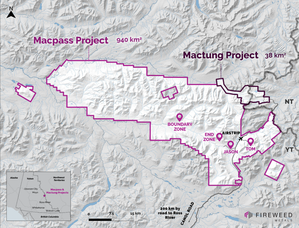
Junior exploration company Fireweed Metals (TSXV:FWZ) has announced new drill results from its 2023 exploration program at the Macmillan Pass Project in Yukon, Canada. The results include the best drill intersection to date from the Boundary Zone target, as well as other high-grade assay results.
Brandon Macdonald, CEO of Fireweed Metals, commented in a press release: “I am excited to start the year able to say that we have intersected our best-ever Boundary Zone drill intersection. We stepped out 140 m along strike from NB22-002 and NB23-007 and hit a spectacular intersection in NB23-028, further supporting our interpretation that there is a continuous high-grade feeder zone within the stratiform unit at Boundary Zone. We now have multiple wide and high-grade intersections that highlight the potential for another large zinc system within this exceptional critical minerals project.”
The mineralization encountered in the latest drill holes at Boundary Zone consists primarily of stratiform (layer-parallel) and massive sulphide zones containing zinc, lead and silver. The sulphide bodies occur over a 550-metre strike length and have been traced from near-surface to depths of at least 450 metres.
Drill hole NB23-028 intersected a broad zone of high-grade massive sulphides interpreted to be associated with a feeder system that supplied metals to the Boundary mineralized system. Additional stratiform massive sulphide zones were hit in holes NB23-022 and NB23-029.
According to Fireweed, step-out drilling has successfully extended the known stratiform sulphide zone down-dip. The tabular stratiform mineralized body ranges from 10 to 50 metres in true thickness. Extensive vein and breccia mineralization has also been encountered adjacent to the main sulphide zone.
In 2023, Fireweed completed a 22,500-metre drill program focused on the Boundary, Tom and Jason zones, as well as several metallurgical drill holes. The large program utilized directional drilling technology to maximize efficiencies.
Assays are still pending for numerous drill intersections from the Boundary Zone where visual inspections identified significant zinc and lead sulphide mineralization. Fireweed reports that step-out drilling has resulted in the visual identification of many wide intervals of sphalerite and galena.
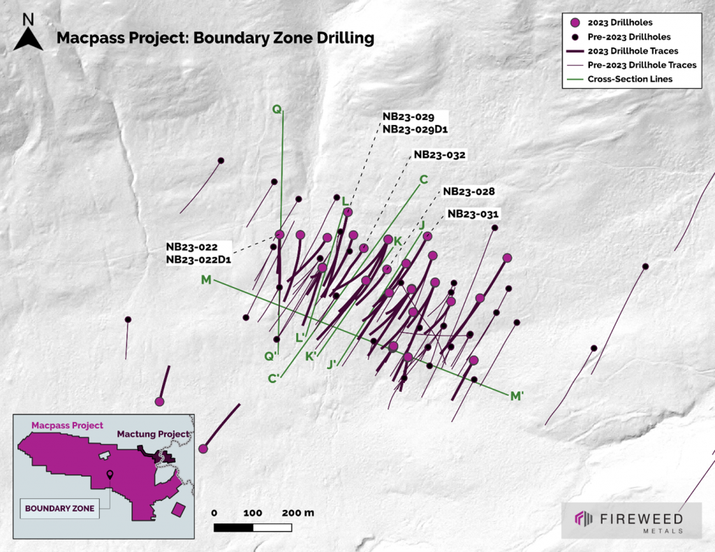
The drill results continue to support the interpretation that the mineralization at Boundary Zone consists of a laterally extensive stratiform sulphide layer. According to Fireweed, this tabular mineralized zone now measures 550 metres along strike and has been traced 450 metres down dip. It remains open in multiple directions.
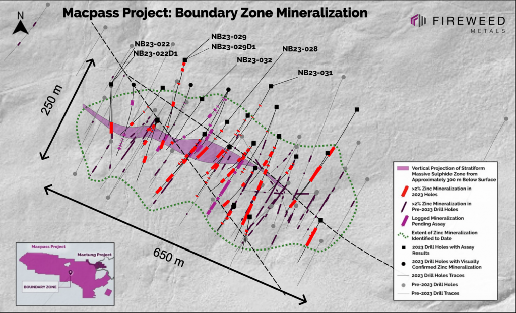
Highlights from the results are as follows:
- Best intersection drilled to date at Boundary Zone: hole NB23-028 intersected 143.95 m (50 m true width) grading 14.45% zinc, 1.15% lead, and 60.0 g/t silver, including 28.71 m (10 m true width) grading 25.52% zinc, 1.27% lead, and 91.3 g/t silver.
- Successful step-out holes continue to increase the extents of known zinc mineralization and demonstrate the high-grade tenor of the Boundary Zone mineralization.
- Hole NB23-022 intersected 66.11 m (18 m true width) grading 7.13% zinc, 0.97% lead, and 54.8 g/t silver.
- Assays are pending for 19 remaining drillholes including six more from Boundary Zone, and 11 holes from the Tom deposit, and two holes from the Jason deposit.
Table 1: Assay highlights for holes included within this release for the 2023 drilling program, Boundary Zone
| Drillhole | Interval | From (m) | To (m) | Interval Width (m) | Est. True Width (m) † |
Zinc (%) | Lead (%) | Silver (g/t) |
Bulk Density (t/m3) |
| NB23-022 | Primary | 282.65 | 348.76 | 66.11 | 18 | 7.13 | 0.97 | 54.8 | 4.47 |
| NB23-028 | Primary | 91.9 | 111.3 | 19.4 | N/A | 3.65 | 0.04 | 5.1 | 3.09 |
| NB23-028 | Including | 94.72 | 98.1 | 3.38 | N/A | 8.55 | 0.07 | 8.1 | 3.39 |
| NB23-028 | Primary | 196.1 | 203.8 | 7.7 | N/A | 9.95 | 0.04 | 12.7 | 2.86 |
| NB23-028 | Including | 197.6 | 202.3 | 4.7 | N/A | 14.23 | 0.06 | 17.9 | 2.91 |
| NB23-028 | Primary | 305.6 | 449.55 | 143.95 | 50 | 14.45 | 1.15 | 60.0 | 3.75 |
| NB23-028 | Including | 310.35 | 314.5 | 4.15 | 1.4 | 14.55 | 4.69 | 163.0 | 3.89 |
| NB23-028 | Including | 321.79 | 350.5 | 28.71 | 10 | 25.52 | 1.27 | 91.3 | 3.90 |
| NB23-028 | >Including | 327.6 | 337.74 | 10.14 | 3.5 | 32.72 | 1.34 | 109.8 | 4.06 |
| NB23-028 | Including | 420.31 | 439.61 | 19.3 | 6.7 | 19.06 | 1.12 | 62.7 | 4.00 |
| NB23-029 | Primary* | 24.14 | 51.95 | 27.81 | N/A | 4.28 | 0.06 | 11.9 | 3.08 |
| NB23-029 | Including* | 24.14 | 31.57 | 7.43 | N/A | 9.21 | 0.05 | 13.8 | 3.07 |
| NB23-029 | Primary* | 79.27 | 108.45 | 29.18 | N/A | 2.93 | 0.02 | 4.6 | 2.77 |
| NB23-029 | Primary | 238.82 | 255.44 | 16.62 | N/A | 8.74 | 0.03 | 11.1 | 3.09 |
| NB23-029 | Including | 239.82 | 245.44 | 5.62 | N/A | 18.39 | 0.06 | 23.6 | 3.49 |
| NB23-029 | Primary | 400.87 | 412.5 | 11.63 | Unknown | 7.49 | 1.66 | 34.7 | 3.14 |
| NB23-029 | Including | 402.82 | 408.38 | 5.56 | Unknown | 13.21 | 0.96 | 34.1 | 3.42 |
| NB23-029 | Primary | 514 | 519.76 | 5.76 | Unknown | 6.32 | 1.50 | 34.6 | 3.06 |
| NB23-029 | Primary | 580.43 | 618.83 | 38.4 | Unknown | 3.06 | 0.08 | 8.2 | 3.47 |
| NB23-029 | Including | 580.43 | 582.86 | 2.43 | Unknown | 11.91 | 0.36 | 26.6 | 4.39 |
| NB23-029 | Including | 601.94 | 604.88 | 2.94 | Unknown | 13.21 | 0.09 | 21.5 | 4.30 |
| NB23-029D1 | Primary | 416.75 | 437.5 | 20.75 | Unknown | 5.20 | 2.05 | 52.6 | 3.80 |
| NB23-029D1 | Including | 423.5 | 430 | 6.5 | Unknown | 8.43 | 3.27 | 82.3 | 4.17 |
| NB23-031 | Primary | 142.4 | 148.9 | 6.5 | N/A | 7.33 | 0.05 | 14.5 | 2.92 |
| NB23-031 | Primary | 235.57 | 240.16 | 4.59 | N/A | 7.33 | 0.02 | 7.7 | 3.23 |
| NB23-031 | Primary | 373.33 | 377.6 | 4.27 | N/A | 7.95 | 0.01 | 3.3 | 2.81 |
| NB23-032 | Primary | 412.55 | 430.92 | 18.37 | 8 | 4.25 | 0.14 | 12.7 | 3.27 |
| NB23-032 | Including* | 412.55 | 417 | 4.45 | 2 | 7.55 | 0.19 | 17.3 | 2.96 |
*denotes intervals with recovery of less than 85%. N/A: Not Applicable due to the variable shapes of breccia and vein mineralization.
† See “Data Verification” for a description of true width calculations
- Hole NB23-028 intersected a 143.95 m interval of stratiform massive sulphide grading 14.45% zinc, 1.15% lead, and 60.0 g/t silver with an estimated true width of approximately 50 m, including 28.71 m (estimated true width 10 m) of 25.52% zinc, 1.27% lead, and 91.3 g/t silver, further including 10.14 m (estimated true width 3.5 m) of 32.72% zinc, 1.34% lead, and 109.8 g/t silver. Two intervals of vein and breccia style mineralization were also intersected, 19.40 m grading 3.65% zinc and 5.1 g/t silver, and 7.70 m grading 9.95% zinc and 12.7 g/t silver.
- Hole NB23-022 intersected 66.11 m of stratiform massive sulphide with an estimated true width of 18 m grading 7.13% zinc, 0.97% lead, and 54.8 g/t silver, including 50.08 m (14 m true width) of 7.99% zinc, 1.12% lead, and 61.7 g/t silver.
- Hole NB23-29D1 is a directionally-cut secondary splay hole from NB23-029 and intersected 20.75 m of stratiform massive sulphide grading 5.20% zinc, 2.05% lead, and 52.6 g/t silver, including 6.50 m of 8.43% zinc, 3.27% lead, and 82.3 g/t silver. This intercept of stratiform mineralization correlates to a separate, distinct body from the primary tabular massive sulphide.
- NB23-029 intersected a 5.76 m interval of stratiform massive sulphide grading 6.32% zinc, 1.50% lead, and 34.6 g/t silver, as well as an 11.63 m interval of stratiform massive sulphide grading 7.49% zinc, 1.66% lead, and 34.7 g/t silver. Four intervals of vein and breccia style mineralization were also intersected: 27.81 m grading 4.28% zinc and 11.9 g/t silver; 29.18 m grading 2.93% zinc and 4.6 g/t silver; 16.62 m grading 8.74% zinc and 11.1 g/t silver; and 38.40 m grading 3.06% zinc and 8.2 g/t silver.
- Hole NB23-032 intersected 18.37 m of stratiform massive sulphide with an estimated true width of 8 m grading 4.25% zinc, 0.14% lead, and 12.7 g/t silver, including 4.45 m of 7.55% zinc, 0.19% lead, and 17.3 g/t silver with an estimated true width of 2 m.
- Hole NB23-031 intersected three zones of breccia and vein style mineralization: 6.50 m grading 7.33% zinc and 14.5 g/t silver; 4.59 m grading 7.33% zinc and 7.7 g/t silver; and 4.27 m grading 7.95% zinc and 3.3 g/t silver.
- Hole NB23-022D1 is a directional cut off NB23-022 and intersected a 2.50 m interval of sulphide mineralization grading 5.13% zinc, 0.43% lead, and 33.8 g/t silver.
- NB23-034 intersected 49 m of stratiform massive sulphide.
- NB23-035 intersected 15 m of stratiform massive sulphide.
- NB23-036 intersected 45 m of stratiform massive sulphide.
- NB23-037 intersected 110 m of feeder-proximal laminated to massive sulphide.
- NB23-038 intersected 13 m of stratiform massive sulphide.
Table 2: NB23-017, NB23-018, NB23-019, NB23-020, NB23-021, NB23-024, NB23-025, NB23-026, NB23-027, NB23-030 drill results
| Drillhole | Interval | From (m) | To (m) | Interval Width (m) | Est. True Width (m) ‡ | Zinc (%) | Lead (%) | Silver (g/t) | Bulk Density (t/m3) |
| NB23-022 | Entire Hole† | 0.00 | 386.00 | 386.00 | N/A | 1.84 | 0.26 | 15.5 | 3.04 |
| NB23-022 | Primary | 282.65 | 348.76 | 66.11 | 18 | 7.13 | 0.97 | 54.8 | 4.47 |
| NB23-022 | Including | 282.65 | 332.73 | 50.08 | 14 | 7.99 | 1.12 | 61.7 | 4.78 |
| NB23-022D1 | Entire Hole† | 0.00 | 448.00 | 448.00 | N/A | 0.07 | 0.02 | 1.5 | 2.76 |
| NB23-022D1 | Primary | 378.50 | 381.00 | 2.50 | N/A | 5.13 | 0.43 | 33.8 | 3.12 |
| NB23-028 | Entire Hole† | 0.00 | 477.00 | 477.00 | N/A | 5.65 | 0.43 | 23.3 | 3.15 |
| NB23-028 | Primary | 91.90 | 111.30 | 19.40 | N/A | 3.65 | 0.04 | 5.1 | 3.09 |
| NB23-028 | Including | 94.72 | 98.10 | 3.38 | N/A | 8.55 | 0.07 | 8.1 | 3.39 |
| NB23-028 | Primary | 196.10 | 203.80 | 7.70 | N/A | 9.95 | 0.04 | 12.7 | 2.86 |
| NB23-028 | Including | 197.60 | 202.30 | 4.70 | N/A | 14.23 | 0.06 | 17.9 | 2.91 |
| NB23-028 | Primary | 305.60 | 449.55 | 143.95 | 50 | 14.45 | 1.15 | 60.0 | 3.75 |
| NB23-028 | Including | 306.44 | 443.23 | 136.79 | 48 | 14.90 | 1.18 | 61.7 | 3.77 |
| NB23-028 | >Including | 310.35 | 314.50 | 4.15 | 1.4 | 14.55 | 4.69 | 163.0 | 3.89 |
| NB23-028 | >Including | 321.79 | 350.50 | 28.71 | 10 | 25.52 | 1.27 | 91.3 | 3.90 |
| NB23-028 | >>Including | 327.60 | 337.74 | 10.14 | 3.5 | 32.72 | 1.34 | 109.8 | 4.06 |
| NB23-028 | >Including | 420.31 | 439.61 | 19.30 | 6.7 | 19.06 | 1.12 | 62.7 | 4.00 |
| NB23-029 | Entire Hole† | 0.00 | 629.50 | 629.50 | N/A | 1.17 | 0.08 | 4.4 | 2.93 |
| NB23-029 | Primary* | 24.14 | 51.95 | 27.81 | N/A | 4.28 | 0.06 | 11.9 | 3.08 |
| NB23-029 | Including* | 24.14 | 31.57 | 7.43 | N/A | 9.21 | 0.05 | 13.8 | 3.07 |
| NB23-029 | Primary* | 79.27 | 108.45 | 29.18 | N/A | 2.93 | 0.02 | 4.6 | 2.77 |
| NB23-029 | Primary | 238.82 | 255.44 | 16.62 | N/A | 8.74 | 0.03 | 11.1 | 3.09 |
| NB23-029 | Including | 239.82 | 246.22 | 6.40 | N/A | 17.05 | 0.06 | 21.6 | 3.40 |
| NB23-029 | Including | 239.82 | 245.44 | 5.62 | N/A | 18.39 | 0.06 | 23.6 | 3.49 |
| NB23-029 | Primary | 400.87 | 412.50 | 11.63 | unknown | 7.49 | 1.66 | 34.7 | 3.14 |
| NB23-029 | Including | 400.87 | 412.00 | 11.13 | unknown | 7.79 | 1.66 | 35.3 | 3.15 |
| NB23-029 | Including | 402.82 | 408.38 | 5.56 | unknown | 13.21 | 0.96 | 34.1 | 3.42 |
| NB23-029 | Primary | 514.00 | 519.76 | 5.76 | unknown | 6.32 | 1.50 | 34.6 | 3.06 |
| NB23-029 | Including | 515.50 | 519.76 | 4.26 | unknown | 7.73 | 1.91 | 39.7 | 3.16 |
| NB23-029 | Primary | 580.43 | 618.83 | 38.40 | unknown | 3.06 | 0.08 | 8.2 | 3.47 |
| NB23-029 | Including | 580.43 | 582.86 | 2.43 | unknown | 11.91 | 0.36 | 26.6 | 4.39 |
| NB23-029 | Including | 601.94 | 604.88 | 2.94 | unknown | 13.21 | 0.09 | 21.5 | 4.30 |
| NB23-029D1 | Entire Hole† | 0.00 | 689.50 | 689.50 | N/A | 0.31 | 0.11 | 3.4 | 2.84 |
| NB23-029D1 | Primary | 416.75 | 437.50 | 20.75 | unknown | 5.20 | 2.05 | 52.6 | 3.80 |
| NB23-029D1 | Including | 423.50 | 430.00 | 6.50 | unknown | 8.43 | 3.27 | 82.3 | 4.17 |
| NB23-031 | Entire Hole† | 0.00 | 574.00 | 574.00 | N/A | 0.46 | 0.01 | 1.9 | 2.83 |
| NB23-031 | Primary | 142.40 | 148.90 | 6.50 | N/A | 7.33 | 0.05 | 14.5 | 2.92 |
| NB23-031 | Including | 142.40 | 147.40 | 5.00 | N/A | 8.76 | 0.06 | 16.5 | 2.96 |
| NB23-031 | Primary | 235.57 | 240.16 | 4.59 | N/A | 7.33 | 0.02 | 7.7 | 3.23 |
| NB23-031 | Primary | 373.33 | 377.60 | 4.27 | N/A | 7.95 | 0.01 | 3.3 | 2.81 |
| NB23-032 | Entire Hole† | 0.00 | 493.34 | 493.34 | N/A | 0.36 | 0.04 | 3.0 | 2.94 |
| NB23-032 | Primary | 412.55 | 430.92 | 18.37 | 8 | 4.25 | 0.14 | 12.7 | 3.27 |
| NB23-032 | Including* | 412.55 | 417.00 | 4.45 | 2 | 7.55 | 0.19 | 17.3 | 2.96 |
* Denotes intervals with recovery of less than 85%; N/A: Not Applicable due to the variable shapes of breccia and vein mineralization.
† Entire hole intervals contain large continuous sections of very low grade or not mineralized material (below 2% zinc)—intersections of continuous higher-grade material (>2% zinc) are listed as Primary and Included intervals and represent mineralized material.
‡ See “Data Verification” for a description of true width calculations
Table 3: 2023 Drilling Summary
| Drillhole | Length (m) | Zone | Significant Intersection | Type |
| NB23-001 | 460 | Boundary | Results disclosed Jul 26 | Step Out |
| NB23-002 | 351 | Boundary | Results disclosed Jul 26 | Step Out |
| NB23-003 | 418 | Boundary | Results disclosed Jul 26 | Step Out |
| NB23-004 | 432 | Boundary | Results disclosed Aug 22 | Step Out |
| NB23-005 | 234 | Boundary | Results disclosed Aug 22 | Step Out |
| NB23-006 | 373 | Boundary | Results disclosed Aug 22 | Step Out |
| NB23-007 | 461 | Boundary | Results disclosed Aug 22 | Step Out |
| NB23-008 | 385 | Boundary | Results disclosed Aug 22 | Step Out |
| NB23-009 | 67 | Boundary | Hole abandoned and redrilled as NB23-011 | Step Out |
| NB23-010 | 96 | Boundary | Results disclosed Oct 24 | Step Out |
| NB23-011 | 289 | Boundary | Results disclosed Oct 24 | Step Out |
| NB23-012 | 452 | Boundary | Results disclosed Oct 24 | Step Out |
| NB23-013 | 551 | Boundary | Results disclosed Oct 24 | Step Out |
| NB23-014 | 223 | Boundary | Results disclosed Oct 24 | Step Out |
| NB23-015 | 339 | Boundary | Results disclosed Oct 24 | Step Out |
| NB23-016 | 460 | Boundary | Results disclosed Oct 24 | Step Out |
| NB23-017 | 96 | Boundary | Results disclosed Nov 30 | Step Out |
| NB23-018 | 195 | Boundary | Results disclosed Nov 30 | Step Out |
| NB23-019 | 560 | Boundary | Results disclosed Nov 30 | Step Out |
| NB23-020 | 414 | Boundary | Results disclosed Nov 30 | Infill |
| NB23-021 | 442 | Boundary | Results disclosed Nov 30 | Infill |
| NB23-022 | 386 | Boundary | Results disclosed this release | Step Out |
| NB23-022D1 | 448 | Boundary | Results disclosed this release | Step Out |
| NB23-023 | 181 | Boundary | Results disclosed Nov 30 | Step Out |
| NB23-024 | 402 | Boundary | Results disclosed Nov 30 | Infill |
| NB23-025 | 580 | Boundary | Results disclosed Nov 30 | Step Out |
| NB23-026 | 111 | Boundary | Results disclosed Nov 30 | Step Out |
| NB23-027 | 396 | Boundary | Results disclosed Nov 30 | Infill |
| NB23-028 | 477 | Boundary | Results disclosed this release | Step Out |
| NB23-029 | 640 | Boundary | Results disclosed this release | Step Out |
| NB23-029D1 | 689 | Boundary | Results disclosed this release | Step Out |
| NB23-030 | 526 | Boundary | Results disclosed Nov 30 | Step Out |
| NB23-031 | 574 | Boundary | Results disclosed this release | Step Out |
| NB23-032 | 495 | Boundary | Results disclosed this release | Step Out |
| NB23-033 | 681 | Boundary | Narrow Zone Encountered | Step Out |
| NB23-034 | 580 | Boundary | Wide Zone Encountered | Step Out |
| NB23-035 | 552 | Boundary | Moderate Zone Encountered | Step Out |
| NB23-036 | 397 | Boundary | Wide Zone Encountered | Step Out |
| NB23-037 | 544 | Boundary | Wide Zone Encountered | Step Out |
| NB23-038 | 427 | Boundary | Moderate Zone Encountered | Step Out |
| TS23-001 | 143 | Tom North | Minor Mineralization Encountered | Step Out |
| TS23-002 | 182 | Tom North | Minor Mineralization Encountered | Step Out |
| TS23-003 | 299 | Tom West | Wide Zone Encountered | Step Out |
| TS23-004 | 369 | Tom West | Moderate Zone Encountered | Step Out |
| TS23-005 | 407 | Tom West | Moderate Zone Encountered | Step Out |
| TS23-006 | 137 | Tom West | Moderate Zone Encountered | Step Out |
| TS23-007 | 215 | Tom West | Moderate Zone Encountered | Step Out |
| TS23-008 | 428 | Tom West | Moderate Zone Encountered | Step Out |
| TS23-009 | 749 | Tom South | Wide Zone Encountered | Step Out |
| TS23-009D1 | 747 | Tom South | Wide Zone Encountered | Redrill |
| TS23-009D2 | 821 | Tom South | Wide Zone Encountered | Step Out |
| JS23-001 | 631 | Jason South | Narrow Zone Encountered | Step Out |
| JS23-001D1 | 665 | Jason South | Wide Zone Encountered | Step Out |
| BX23-001 | 219 | Boundary South | No significant mineralization | Exploration |
| BX23-002 | 144 | Boundary South | No significant mineralization | Exploration |
| KB23-001 | 368 | Kobuk | No significant mineralization | Exploration |
| KB23-002 | 284 | Kobuk | No significant mineralization | Exploration |
Table 4: Drill Hole Collar Information
| Drillhole | Zone | Length (m) | Easting | Northing | Elevation (m.s.l) | Azimuth (°) | Dip (°) |
| NB23-001 | Boundary | 460 | 422297 | 7010471 | 1185.86 | 211.99 | -76.42 |
| NB23-002 | Boundary | 351 | 422235 | 7010525 | 1194.57 | 214.06 | -70.22 |
| NB23-003 | Boundary | 418 | 422235 | 7010525 | 1194.57 | 213.40 | -78.00 |
| NB23-004 | Boundary | 432 | 422171 | 7010556 | 1203.00 | 213.91 | -78.08 |
| NB23-005 | Boundary | 234 | 422058 | 7010589 | 1207.95 | 199.63 | -49.74 |
| NB23-006 | Boundary | 373 | 422171 | 7010556 | 1203.00 | 215.44 | -70.02 |
| NB23-007 | Boundary | 461 | 422058 | 7010589 | 1207.95 | 206.37 | -86.43 |
| NB23-008 | Boundary | 385 | 422171 | 7010556 | 1203.00 | 215.83 | -60.07 |
| NB23-009 | Boundary | 67 | 422058 | 7010589 | 1208.67 | 198.54 | -75.41 |
| NB23-010 | Boundary | 96 | 422241 | 7010385 | 1150.41 | 212.28 | -45.00 |
| NB23-011 | Boundary | 289 | 422058 | 7010589 | 1208.67 | 201.59 | -75.40 |
| NB23-012 | Boundary | 452 | 422289 | 7010534 | 1200.90 | 211.75 | -69.90 |
| NB23-013 | Boundary | 551 | 422072 | 7010666 | 1233.59 | 214.94 | -77.68 |
| NB23-014 | Boundary | 223 | 422241 | 7010384 | 1150.86 | 213.68 | -70.83 |
| NB23-015 | Boundary | 339 | 422241 | 7010385 | 1150.41 | 213.36 | -84.00 |
| NB23-016 | Boundary | 461 | 422274 | 7010600 | 1216. 70 | 209.88 | -72.96 |
| NB23-017 | Boundary | 96 | 422279 | 7010359 | 1142.67 | 191.27 | -46.90 |
| NB23-018 | Boundary | 195 | 422279 | 7010359 | 1142.67 | 190.21 | -65.21 |
| NB23-019 | Boundary | 561 | 422289 | 7010534 | 1200.90 | 209.95 | -81.31 |
| NB23-020 | Boundary | 414 | 422465 | 7010510 | 1191.44 | 204.85 | -63.35 |
| NB23-021 | Boundary | 442 | 422391 | 7010500 | 1190.07 | 201.97 | -77.01 |
| NB23-022 | Boundary | 386 | 421948 | 7010672 | 1232.44 | 178.85 | -74.18 |
| NB23-022D1 | Boundary | 448 | 421948 | 7010672 | 1232.44 | 177.78 | -74.00 |
| NB23-023 | Boundary | 181 | 422449 | 7010351 | 1145.42 | 211.82 | -49.18 |
| NB23-024 | Boundary | 405 | 422348 | 7010550 | 1203.82 | 199.65 | -50.18 |
| NB23-025 | Boundary | 582 | 422343 | 7010620 | 1219.03 | 196.94 | -74.05 |
| NB23-026 | Boundary | 111 | 422449 | 7010351 | 1145.42 | 210.02 | -65.44 |
| NB23-027 | Boundary | 451 | 422348 | 7010550 | 1203.82 | 197.18 | -72.46 |
| NB23-028 | Boundary | 467 | 422222 | 7010587 | 1209.75 | 211.38 | -65.44 |
| NB23-029 | Boundary | 630 | 422124 | 7010731 | 1250.31 | 196.21 | -75.67 |
| NB23-029D1 | Boundary | 690 | 422124 | 7010731 | 1250.31 | 196.21 | -75.67 |
| NB23-030 | Boundary | 526 | 422535 | 7010614 | 1214.65 | 211.44 | -62.01 |
| NB23-031 | Boundary | 574 | 422329 | 7010671 | 1235.88 | 207.69 | -69.87 |
| NB23-032 | Boundary | 493 | 422165 | 7010640 | 1224.09 | 210.08 | -62.01 |
| NB23-033 | Boundary | 681 | 422228 | 7010663 | 1233.01 | 211.31 | -73.88 |
| NB23-034 | Boundary | 580 | 422138 | 7010674 | 1237.24 | 199.07 | -72.40 |
| NB23-035 | Boundary | 552 | 422228 | 7010663 | 1232.97 | 199.00 | -72.02 |
| NB23-036 | Boundary | 398 | 422289 | 7010534 | 1200.89 | 212.26 | -59.46 |
| NB23-037 | Boundary | 544 | 422228 | 7010663 | 1232.94 | 204.73 | -66.10 |
| NB23-038 | Boundary | 427 | 422001 | 7010675 | 1233.60 | 179.75 | -68.10 |
| TS23-001 | Tom North | 143 | 441761 | 7004226 | 1492.16 | 075.08 | -49.66 |
| TS23-002 | Tom North | 182 | 441761 | 7004226 | 1492.16 | 074.97 | -80.38 |
| TS23-003 | Tom West | 299 | 441676 | 7004024 | 1445.00 | 074.17 | -68.51 |
| TS23-004 | Tom West | 369 | 441694 | 7003884 | 1463.34 | 067.38 | -71.48 |
| TS23-005 | Tom West | 407 | 441761 | 7003770 | 1510.00 | 063.25 | -75.35 |
| TS23-006 | Tom West | 137 | 441779 | 7004076 | 1485.36 | 065.15 | -50.08 |
| TS23-007 | Tom West | 215 | 441779 | 7004076 | 1485.36 | 065.23 | -78.04 |
| TS23-008 | Tom West | 428 | 441816 | 7003717 | 1538.00 | 089.53 | -88.95 |
| TS23-009 | Tom South | 749 | 442363 | 7003106 | 1747.29 | 351.97 | -82.00 |
| TS23-009D1 | Tom South | 748 | 442363 | 7003106 | 1747.29 | 351.97 | -82.00 |
| TS23-009D2 | Tom South | 821 | 442363 | 7003106 | 1747.29 | 351.97 | -82.00 |
| JS23-001 | Jason South | 631 | 436722 | 7002304 | 1185.00 | 228.15 | -83.90 |
| JS23-001D1 | Jason South | 665 | 436722 | 7002304 | 1185.00 | 228.15 | -83.90 |
| BX23-001 | Boundary Expl. | 219 | 421752 | 7010127 | 1114.70 | 035.16 | -50.19 |
| BX23-002 | Boundary Expl. | 144 | 421637 | 7010243 | 1137.50 | 014.78 | -49.83 |
| KB23-001 | Kobuk | 368 | 418651 | 7012138 | 1311.00 | 006.19 | -51.12 |
| KB23-002 | Kobuk | 284 | 418754 | 7011620 | 1225.00 | 006.00 | -65.24 |
Coordinates listed in NAD83 UTM Zone 9N.
The above references an opinion and is for information purposes only. It is not intended to be investment advice. Seek a licensed professional for investment advice. The author is not an insider or shareholder of any of the companies mentioned above.
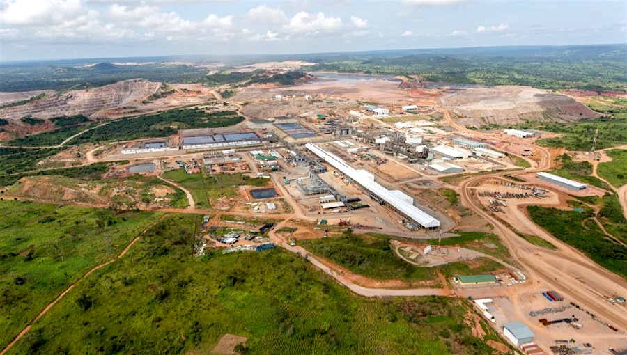
China Molybdenum Co. Ltd. (CMOC), a leading global mineral company headquartered in Beijing, produced 55,526 tons of cobalt in 2023, representing a 170% increase from 20,581 tons in 2022, according to a company filing on Thursday. This production level exceeds CMOC’s own guidance by over 20% and enables the company to surpass Glencore Plc (LON:GLEN) as the world’s largest cobalt producer.
Glencore, headquartered in Baar, Switzerland, had forecasted cobalt production of up to 42,000 tons in 2023. The company is scheduled to announce full 2023 production results next month. CMOC’s massive increase in output is largely attributed to the Kisanfu cobalt-copper mine in the Democratic Republic of Congo (DRC), which came online in the second quarter of 2022. The $1.8 billion Kisanfu mine is owned by CMOC’s Congolese subsidiary Tenke Fungurume Mining S.A. (TFM).
Along with rising production from Indonesia, CMOC’s increased cobalt supply has contributed to a substantial surplus in the cobalt market in 2023. This oversupply triggered a 30% drop in cobalt prices over the course of last year. By mid-2023, the mismatch between supply and demand had become so severe that Glencore began stockpiling surplus cobalt from its DRC operations in an effort to balance the market.
In addition to being the world’s top cobalt producer, CMOC is now one of the leading global copper producers. The company’s copper output jumped 51% to 419,539 tons in 2023. CMOC’s rising cobalt and copper production comes at a time when many miners are struggling to increase output to meet growing demand, especially for electric vehicle batteries.
Cobalt is a critical mineral used in lithium-ion batteries for electric vehicles, consumer electronics and energy storage systems. Approximately 70% of the world’s cobalt is mined in the DRC, a country plagued by political instability, human rights violations, child labour and other ethical concerns. Major multinational mining companies like Glencore and CMOC have faced scrutiny over their DRC operations.
Cobalt mining is dominated by large firms from China, Switzerland and Canada. Artisanal small-scale cobalt mining by hand is also common in the DRC, frequently under dangerous, unregulated conditions. The human rights watchdog Amnesty International has reported children as young as seven years old working in Congolese artisanal cobalt mines.
Technological advances and recycling may reduce future cobalt demand growth, but it remains an essential battery ingredient. As the electric vehicle market expands dramatically in the coming decades, ethical and sustainable cobalt sourcing from conflict-free mines will become increasingly important, as CMOC and other industry leaders continue to prove their operations are operating in a conflict-free manner.
The above references an opinion and is for information purposes only. It is not intended to be investment advice. Seek a licensed professional for investment advice. The author is not an insider or shareholder of any of the companies mentioned above.

Solaris Resources (TSX:SLS) (OTCQB:SLSSF) has made a series of new announcements for 2024 that set its plans for drilling, a new listing, and further progress at the Warintza Project. The company intends to list on the NYSE American Stock Exchange to give U.S. retail and institutional investors interested in Solaris expanded access to the stock. Solaris Resources will file a Form 40-F Registration Statement with the U.S. Securities and Exchange Commission prior to NYSE American listing. Subject to approval of the listing application and meeting all requirements, the company expects its shares to start trading on NYSE American in the first half of 2024.
In the second quarter of 2024, the company plans to release an updated mineral resource estimate for Warintza. The new estimate is expected to nearly double the drill meterage included compared to the previous estimate. It is anticipated to show major growth by expanding the deposit from extensional drilling at Warintza Central and Warintza East, and incorporating the recent Warintza Southeast discovery within a shared pit shell.
Solaris Resources also plans to commence its third phase of drilling at Warintza soon. This will include extensional drilling at Warintza East and Warintza Southeast where the deposits remain open. It also includes approximately 30 kilometres of infill drilling to further define mineral resources within the pit shell ahead of studies. Some holes will be extended to also provide technical data for mine design and planning.
Additional 2024 plans for Warintza exploration include a follow-up on the recent Patrimonio discovery. Initial reconnaissance holes there intersected 144 meters of 0.50% CuEq and 148 meters of 0.52% CuEq. Notably, these intercepts contained skarn mineralization whose source has not yet been found. Vectors for the mineralization trend northwest over 1 kilometer untested toward Warintza West, while the strongest soil anomalies at Patrimonio remain untested in the south.
The company also intends to revisit the El Trinche area forming Warintza Central’s southern low-grade margin. A near-surface high-grade intercept within a broader low-grade interval was interpreted as a dike, with orientations and alteration suggesting a potentially deeper, higher-grade system not yet located.
For regional exploration, fieldwork is planned to define drill targets at prospective areas from the program so far. These include Medio Camino, Clemente, Mateo, and Caya.
The company expects to finalize and submit the Environmental Impact Assessment for regulatory approval in the second half of 2024, after over three years of baseline monitoring and data collection. Follow-up programs for metallurgy, geotechnical and hydrogeological drilling will proceed under recently appointed COO Javier Toro through year-end, along with infrastructure, water, power and other studies.
The above references an opinion and is for information purposes only. It is not intended to be investment advice. Seek a licensed professional for investment advice. The author is not an insider or shareholder of any of the companies mentioned above.
Cascadia Minerals (TSXV:CAM) has recently disclosed the final results of its diamond drilling exploration in 2023 at the Catch Property, a wholly-owned asset situated in central Yukon, Canada. This property, extending over 117 square kilometres, is conveniently located just 10 kilometres from an all-season highway and powerline, falling within the traditional territory of the Little Salmon Carmacks First Nation.
Graham Downs, Cascadia’s President and CEO commented in a press release: “Following our successful 2023 exploration season we are eager to follow-up with an expanded program in 2024. We have already made a significant copper-gold discovery at the Diorite Zone (116.60 m of 0.31% copper and 0.30 g/t gold) and continue to be confident in the potential of the Main Zone due to the abundance of mineralization, and high-level alteration signatures in drill core. Our team is excited to commence the 2024 Diorite Zone expansion drill program and to continue exploring numerous untested targets throughout the recently enlarged property. Cascadia is very well positioned to provide significant shareholder value with continued 2024 exploration success. As a brand-new company with a meaningful new discovery, we look forward to getting the Cascadia story out to a broader audience in 2024.”
The Catch Property, earmarked for its potential mineral wealth, underwent its inaugural diamond drill campaign in 2023. The outcomes of this initial exploration were promising, leading Cascadia Minerals to acquire an additional 227 claims. This expansion increased the property’s size by 46 square kilometres, making the total area of exploration 117 square kilometres. The company is now gearing up for a follow-up drilling program, scheduled to start in the spring of 2024. The commencement of this program is subject to favourable snowfall conditions, with a targeted start around late April or early May.
The 2024 drilling agenda includes a minimum of 5,000 meters of diamond drilling. The primary focus will be on the Diorite Zone, particularly building upon the discovery hole CA-23-002. This hole yielded significant findings, including 116.60 meters of 0.31% copper and 0.30 g/t gold. The 2024 drilling efforts will aim at significant lateral and depth step-outs in regions exhibiting strong geophysical anomalies, with a specific focus on the potassic core of the system.
In 2023, drilling at the Diorite Zone was limited to the westernmost IP section line. This area revealed numerous outcrops with substantial copper grades coinciding with a chargeability anomaly at depth. A stronger IP anomaly located 300 meters east, in a region with limited outcrop exposure, is set to be the focal point of the 2024 drilling. The diamond drill, stationed on an undrilled pad in this eastern IP section, will start with several deep holes in this area, as well as undercutting the 2023 drill holes.
Additional exploration is planned at the Main Zone to further assess the mineralization and locate the bedrock source for future drilling guidance. New IP data will be collected between the Diorite and Main zones, an area where surface copper and gold mineralization was detected in 2023. Prospecting, mapping, and soil sampling will also be conducted across the expanded property to pursue newly identified anomalies and pinpoint additional targets.
The 2023 exploration at the Catch Property comprised five drill holes totalling 2,461.83 meters. The first two holes, drilled at the Diorite Zone, encountered basalt, diorite, and gabbro host rocks with mineralization associated with propylitic to sodic alteration. Copper and gold mineralization were noted along with quartz-carbonate ± pyrite-chalcopyrite veins and disseminated to blebby pyrite, pyrrhotite, and chalcopyrite. The remaining three holes at the Main Zone revealed broad zones of propylitic alteration and evidence of major structures. These holes suggested that mineralization may be emanating from a deeper source, as indicated by elevated copper and gold readings in several faults.
The property’s geology and mineralization point to a significant copper-gold ± molybdenum bearing porphyry system. The Catch area is predominantly composed of augite phyric basalt of the Semenof Formation, centred on a large regional magnetic high. The alteration and mineralization observed suggest the presence of a substantial mineral system, underpinned by secondary copper minerals like malachite, azurite, and tenorite, often found in association with gypsum at surface levels.
Highlights from the results are as follows:
- 2023 inaugural diamond drilling resulted in a copper-gold porphyry discovery at the Diorite Zone with Hole CA-23-002 intersecting 116.60 m of 0.31% copper and 0.30 g/t gold (see November 16 news release for details);
- Drilling at the Main Zone (holes CA-23-003 to -005), located 2 km north of the Diorite Zone, intersected high-level porphyry alteration and anomalous copper-gold values, but has not yet identified the source of extensive copper-gold mineralization in a localized landslide;
- Additional 227 contiguous claims recently staked to cover additional prospective ground, expanding the Catch property to 117 km2 in size;
- Drilling has yet to intersect significant potassic alteration, suggesting there is potential to discover higher copper and gold grades in untested areas in the core of the porphyry systems;
- Planning is underway for an early 2024 follow-up diamond drill program;
- Systematic property-wide soil sampling has identified numerous additional copper anomalies across the property, as far as 10 km away from the Diorite Zone; and
- Cascadia will be showcasing Catch core at the upcoming Vancouver Resource Investment Conference (Jan 21-22) and AME Roundup (Jan 22-25) in Vancouver
Table 1: 2023 Catch Assays Result Summary
|
Drill Hole |
From (m) |
To (m) |
Interval (m)* |
Copper (%) |
Gold (g/t) |
|
CA-23-001 |
14.00 |
347.87 |
333.87 |
0.13 |
0.04 |
|
incl. |
14.00 |
59.83 |
45.83 |
0.30 |
0.15 |
|
CA-23-002 |
80.00 |
515.00 |
435.00 |
0.16 |
0.09 |
|
incl. |
356.00 |
472.60 |
116.60 |
0.31 |
0.30 |
|
and incl. |
357.93 |
362.00 |
4.07 |
0.51 |
6.03 |
|
and incl. |
407.00 |
472.60 |
65.60 |
0.40 |
0.13 |
|
CA-23-003** |
205.64 |
209.00 |
3.36 |
0.15 |
0.05 |
|
and |
226.53 |
228.00 |
1.47 |
0.12 |
0.04 |
|
and |
274.00 |
275.00 |
1.00 |
0.16 |
0.29 |
|
CA-23-004** |
382.00 |
385.00 |
3.00 |
0.01 |
2.66 |
|
CA-23-005** |
No Significant Results |
||||
|
* The reported intervals are drilled thicknesses and true widths are unknown. |
|
** Newly reported holes in this release. |
Table 2: 2023 Catch Drill Hole Collars***
|
Drill Hole |
Zone |
Easting |
Northing |
Elevation |
Azimuth |
Dip |
Depth |
|
CA-23-001 |
Diorite |
482,726 |
6,859,800 |
735 |
130 |
-60 |
511.83 |
|
CA-23-002 |
Diorite |
482,702 |
6,859,958 |
772 |
130 |
-65 |
554.00 |
|
CA-23-003 |
Main |
482,848 |
6,861,850 |
1,034 |
040 |
-60 |
440.00 |
|
CA-23-004 |
Main |
482,845 |
6,861,848 |
1,030 |
200 |
-75 |
478.00 |
|
CA-23-005 |
Main |
482,518 |
6,861,580 |
900 |
040 |
-60 |
478.00 |
|
*** Easting and Northing are UTM co-ordinates in the NAD 83 datum, zone 8N. Azimuth is with respect to true north. |
The above references an opinion and is for information purposes only. It is not intended to be investment advice. Seek a licensed professional for investment advice. The author is not an insider or shareholder of any of the companies mentioned above.
Pan American Energy Corp. (CSE:PNRG) recently completed its Phase One drilling program at the Big Mack Lithium Project, situated about 80 kilometres north of Kenora, Ontario. This program, executed by Fullforce Diamond Drilling Ltd. with geological support from Axiom Exploration Group Ltd., concluded both within the scheduled time frame and under budget.
Jason Latkowcer, Chief Executive Officer, commented in a press release: “We are extremely pleased with the execution and results of our Phase One, 2023, drilling program. Completing the first leg of the program on time and under budget is a testament to the efficacy of our team and contractors. We are fully-funded to complete the planned follow-on exploration initiatives at the Project, including the Phase Two drill program and the related resource modelling and reporting, geophysics, and field prospecting programs.”
The focus of Phase One was on exploring targets identified through historical drilling, a UAV magnetic survey, and the company’s field prospecting in 2023. With the successful completion of this phase, American Energy Corp. is now preparing for Phase Two. This subsequent phase aims to continue investigating the potential mineralization of critical minerals at the site. The company anticipates that the extensive drilling undertaken in Phase One will enable it to estimate a mineral resource in accordance with National Instrument 43-101 – Standards of Disclosure for Mineral Projects upon completing Phase Two.
The Big Mack Lithium Project, located 2 kilometres east of Snook Lake Road and in proximity to Avalon’s Separation Rapids Big Whopper deposit, sits within an established mining lease. This region, with over three decades of exploration history, is also within the traditional land use area of the Wabaseemoong Independent Nations of Whitedog, Ontario, approximately 35 kilometres southwest of the project.
The site is known for hosting four Li-bearing pegmatites: the Big Mack pegmatite, Eleven Zone, Sprinkler Zone, and 6095 pegmatite. These pegmatites, linked to the Separation Rapids Pluton, are classified as zoned Complex Type, Petalite Subtype LCT Pegmatites. The Big Mack pegmatite, notable for being the largest petalite-bearing mass in the area, has been exposed over a significant area. Historical drilling efforts in 1998, 1999, and 2001 revealed mineralization extending along a strike length of about 150 meters and to a depth of 75 meters. The mineralization at the project site remains open for further exploration both at depth and along the strike.
Highlights from the results are as follows:
Phase One 2023 Drilling Program:
- Big Mack Pegmatite: Drilled 19 holes (including BM 23-001) totaling 1,984 meters resulting in the extension of the known pegmatite at depth.
- Eleven Zone: Drilled 7 holes totaling 879 meters resulting in the extension of the known pegmatite both at depth and along strike to the west.
- Drill Hole BM23-001 Result: Testing the interior section of the Big Mack Pegmatite, returned assay values of 1.13% Li2O over 27.98 m. For additional information regarding Drill Hole BM23-001 please see the Company’s news release dated December 12, 2023, filed on the Company’s SEDAR+ profile at www.sedarplus.ca.
Phase One 2023 Drilling Program Details:
- Commencement Date: Mobilization and drill start dates respectively: October 31st and November 3rd, 2023
- Shutdown Date: Drilling stop date and crew’s last day on site: December 14th and December 19th, 2023
- Total Number of Drillholes: 34 completed holes (BM23-001 to BM23-0034) and one abandoned hole (BM23-001A)
- Total Meters Drilled: 4,582 meters drilled in 2023
- Geochemical Assay Samples: A total of 2,337 samples have been taken across the 34 completed holes. Of these, 1,817 samples have been delivered to ALS Global for geochemical assays. The remaining 520 samples will be cut and submitted in early January, 2024.
| Drill Hole ID | Dip (°) | Azimuth (°) | Total Depth (m) | Core Size |
| BM23-001 | -45 | 180 | 66 | NQ |
| BM23-002 | -45 | 180 | 72 | NQ |
| BM23-003 | -45 | 180 | 135 | NQ |
| BM23-004 | -55 | 175 | 78 | NQ |
| BM23-005 | -46 | 195 | 102 | NQ |
| BM23-006 | -45 | 180 | 60 | NQ |
| BM23-007 | -45 | 180 | 60 | NQ |
| BM23-008 | -52 | 179 | 90 | NQ |
| BM23-009 | -45 | 358 | 174 | NQ |
| BM23-010 | -45 | 185 | 72 | NQ |
| BM23-011 | -45 | 180 | 84 | NQ |
| BM23-012 | -47 | 181 | 93 | NQ |
| BM23-013 | -48 | 180 | 108 | NQ |
| BM23-014 | -45 | 179 | 133 | NQ |
| BM23-015 | -58 | 178 | 180 | NQ |
| BM23-016 | -45 | 0 | 72 | NQ |
| BM23-017 | -45 | 0 | 72 | NQ |
| BM23-018 | -46 | 359 | 120 | NQ |
| BM23-019 | -46 | 359 | 162 | NQ |
| BM23-020 | -46 | 0 | 132 | NQ |
| BM23-021 | -47 | 359 | 180 | NQ |
| BM23-022 | -46 | 359 | 141 | NQ |
| BM23-023 | -46 | 179 | 156 | NQ |
| BM23-024 | -60 | 178 | 168 | NQ |
| BM23-025 | -46 | 179 | 111 | NQ |
| BM23-026 | -45 | 178 | 165 | NQ |
| BM23-027 | -50 | 40 | 300 | NQ |
| BM23-028 | -70 | 180 | 204 | NQ |
| BM23-029 | -45 | 200 | 201 | NQ |
| BM23-030 | -45 | 200 | 150 | NQ |
| BM23-031 | -45 | 200 | 150 | NQ |
| BM23-032 | -60 | 195 | 180 | NQ |
| BM23-033 | -45 | 250 | 129 | NQ |
| BM23-034 | -45 | 20 | 231 | NQ |
Table 1: Completed 2023 drill hole attributes
The above references an opinion and is for information purposes only. It is not intended to be investment advice. Seek a licensed professional for investment advice. The author is not an insider or shareholder of any of the companies mentioned above.
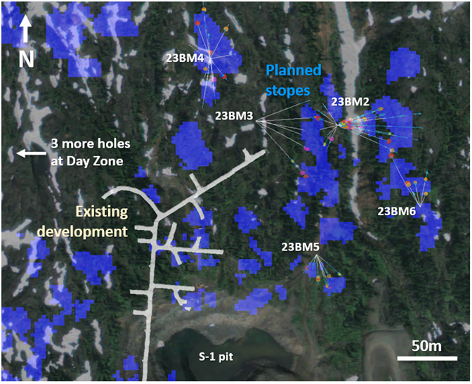
Ascot Resources (TSX:AOT) has reported the final set of assay results from its 2023 exploration drill program. This program was conducted at the company’s Premier Gold Project, which is situated on the Nisga’a Nation Treaty Lands within the Golden Triangle area of northwestern British Columbia, known for its mineral wealth. The announcement specifically relates to the Big Missouri deposit, located about six kilometres north of the Premier mill.
Derek White, President and CEO of Ascot Resources commented in a press release: “Our 2023 surface drilling program finished on a high note, with many planned stope shapes at Big Missouri being confirmed and, in some cases, expanded. We look forward to exploiting this material in the coming months and processing it at the Premier mill, where we anticipate starting pre-commissioning shortly. Similar confirmatory and expansion results were achieved in 2023 at the Prew Zone of the Premier Deposit, where underground access development is also being progressed. Overall, the 2023 drill program enhances our confidence in the geological model, which is all the more important as we become Canada’s next gold producer.”
The exploration drilling at Big Missouri, which forms part of the Premier Gold Project, took place from the beginning of August until the end of October 2023. During this period, a total of 72 holes were drilled from the surface, covering a cumulative length of 6,539 meters. The latest results come from 55 of these holes, spanning a distance of 5,293 meters. These holes were drilled from six different pads and included three holes at the Day Zone on the western side of Big Missouri Ridge.
The primary objective of this drilling exercise was to refine the shapes of various mining stopes. This was done by targeting additional pierce points and addressing gaps between stopes that resulted from previous drilling patterns. The drilling also aimed to explore extensions along the strike and up dip of the deposit. To provide a clearer understanding, the company included an overview of the drill hole locations (Figure 1), a summary of assay results (Table 1), and the coordinates for the drill pads (Table 2) in its report.
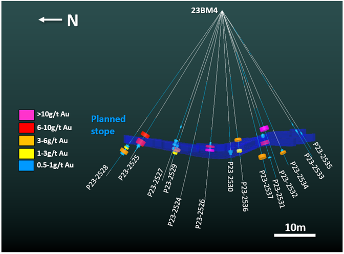
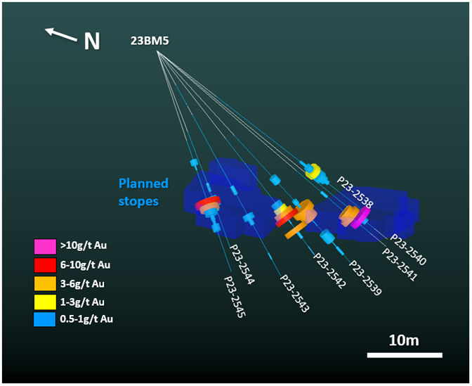
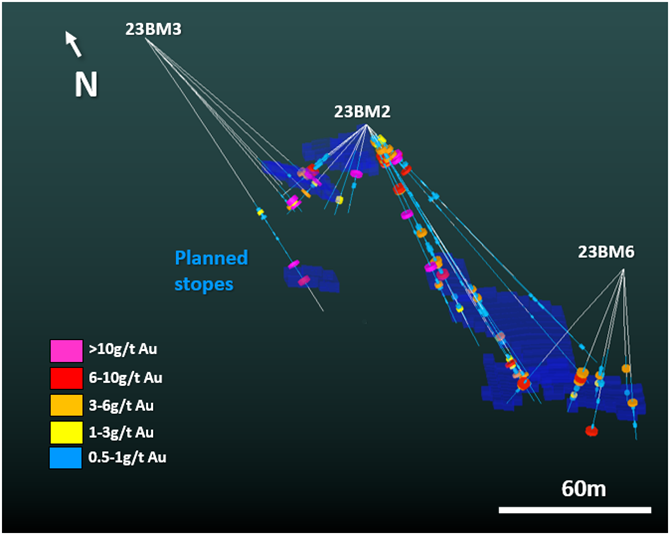
Figures 2 to 4 in the report provide cross-sectional views of the reported drill holes. Importantly, Figure 2 highlights a large stope shape that has been more precisely defined by the recent drilling. For instance, drill hole P23-2532 intersected a notable gold grade of 58.18 grams per ton (g/t) over a 1.99-meter section at a depth of 70.8 meters.
The Day Zone, situated on the western flank of the Big Missouri ridge, was a particular focus. Three drill holes, P23-2515 to 2517, were executed in this area. Previously, the company had identified gold mineralization over a 550-meter strike length at the Day Zone. The potential for further expansion was indicated by IP geophysics conducted in 2023, suggesting a possible extension of 800 meters. While the drilling did encounter gold grades as high as 7.7 g/t, these were not consistent, indicating that further exploration and drilling will be necessary. The next phase of exploration aims to investigate the 1,000-meter unexplored gap between the Day Zone and the Martha Ellen deposit to the northwest.
Concurrently, underground mine development is progressing at the Big Missouri site, particularly in areas targeted for stoping. These areas are included in the near-term mining plans of Ascot Resources, indicating that the company is moving forward with developing this part of the Premier Gold Project.
Highlights from the results are as follows:
- 58.18 g/t Au over 1.99m from a depth of 70.8m in hole P23-2532, including 77.45 g/t Au over 0.99m.
- 9.89 g/t Au over 6.94m from a depth of 22.7m in hole P23-2509B, including 51.00 g/t Au over 1.19m
- 8.26 g/t Au over 7.35m from a depth of 7.35m in hole P23-2506, including 30.88 g/t Au over 1.44m
- 8.26 g/t Au over 5.57m from a depth of 16.9m in hole P23-2499, including 15.75 g/t Au over 1.27m
Table 1 – Big Missouri drill results
| Hole # | Azimuth /dip |
From (m) |
To (m) |
Width (m) |
Au (g/t) |
Ag (g/t) |
| P23-2498 | -59/70 | 8.30 | 11.40 | 3.10 | 3.78 | 35.51 |
| incl. | 9.40 | 10.40 | 1.00 | 5.18 | 68.40 | |
| and | 19.45 | 23.20 | 3.75 | 7.43 | 25.97 | |
| incl. | 21.10 | 22.15 | 1.05 | 21.20 | 54.30 | |
| and | 100.30 | 108.10 | 7.80 | 3.15 | 6.34 | |
| and | 127.05 | 129.03 | 1.98 | 2.88 | 5.40 | |
| P23-2499 | -64/70 | 7.54 | 22.47 | 14.93 | 4.56 | 14.36 |
| incl. | 16.90 | 22.47 | 5.57 | 8.26 | 24.66 | |
| incl. | 21.20 | 22.47 | 1.27 | 15.75 | 62.70 | |
| and | 36.00 | 38.02 | 2.02 | 5.78 | 3.40 | |
| and | 57.68 | 59.44 | 1.76 | 3.26 | 6.50 | |
| and | 65.79 | 80.27 | 14.48 | 2.20 | 6.01 | |
| incl. | 69.79 | 71.79 | 2.00 | 3.24 | 6.10 | |
| and | 97.40 | 98.64 | 1.24 | 3.46 | 10.60 | |
| P23-2500 | -61/78 | 8.10 | 21.69 | 13.59 | 2.61 | 14.86 |
| incl. | 19.62 | 21.69 | 2.07 | 5.74 | 31.30 | |
| and | 39.82 | 48.00 | 8.18 | 1.25 | 5.66 | |
| and | 102.11 | 110.70 | 8.59 | 2.50 | 15.21 | |
| and | 122.70 | 126.69 | 3.99 | 2.94 | 4.86 | |
| incl. | 122.70 | 123.83 | 1.13 | 5.04 | 8.80 | |
| P23-2501 | -65/79 | 7.40 | 11.50 | 4.10 | 2.60 | 11.68 |
| and | 18.50 | 21.55 | 3.05 | 5.68 | 18.96 | |
| and | 34.30 | 36.00 | 1.70 | 6.89 | 5.80 | |
| and | 55.50 | 60.00 | 4.50 | 2.74 | 6.23 | |
| and | 74.05 | 82.87 | 8.82 | 4.24 | 17.29 | |
| and | 98.30 | 101.00 | 2.70 | 3.35 | 14.63 | |
| P23-2502 | -50/82 | 8.71 | 11.90 | 3.19 | 3.67 | 11.20 |
| and | 18.85 | 22.97 | 4.12 | 4.05 | 15.85 | |
| incl. | 20.69 | 21.81 | 1.12 | 8.27 | 17.20 | |
| and | 113.25 | 117.35 | 4.10 | 1.93 | 8.10 | |
| P23-2503 | -49/92 | 18.85 | 23.00 | 4.15 | 6.59 | 10.66 |
| incl. | 18.85 | 20.35 | 1.50 | 12.35 | 14.90 | |
| and | 43.55 | 46.50 | 2.95 | 2.69 | 5.98 | |
| P23-2504 | -60/100 | 12.34 | 18.84 | 6.50 | 4.22 | 7.06 |
| incl. | 17.20 | 18.84 | 1.64 | 6.96 | 10.10 | |
| and | 53.34 | 61.62 | 8.28 | 1.32 | 19.78 | |
| and | 97.48 | 101.24 | 3.76 | 1.57 | 68.56 | |
| and | 121.15 | 124.18 | 3.03 | 2.95 | 26.41 | |
| P23-2505 | -67/99 | 16.20 | 21.94 | 5.74 | 1.60 | 11.23 |
| and | 44.20 | 45.68 | 1.48 | 11.20 | 12.80 | |
| and | 70.20 | 71.95 | 1.75 | 10.80 | 10.60 | |
| and | 79.11 | 81.77 | 2.66 | 3.86 | 5.83 | |
| P23-2506 | -52/100 | 13.90 | 21.25 | 7.35 | 8.26 | 12.84 |
| incl. | 19.81 | 21.25 | 1.44 | 30.88 | 38.45 | |
| and | 26.40 | 27.40 | 1.00 | 8.67 | 8.30 | |
| and | 42.20 | 44.20 | 2.00 | 2.30 | 6.20 | |
| and | 111.65 | 112.56 | 0.91 | 1.88 | 18.20 | |
| P23-2507 | -59/108 | 9.12 | 18.68 | 9.56 | 1.99 | 6.35 |
| and | 26.24 | 29.52 | 3.28 | 1.25 | 10.73 | |
| and | 58.00 | 61.00 | 3.00 | 1.77 | 3.37 | |
| P23-2508 | -57/115 | 13.10 | 20.20 | 7.10 | 1.46 | 7.02 |
| and | 125.77 | 130.37 | 4.60 | 2.78 | 27.37 | |
| incl. | 127.26 | 128.37 | 1.11 | 5.11 | 71.70 | |
| P23-2509 | -42/213 | 35.18 | 37.29 | 2.11 | 3.87 | 6.80 |
| P23-2509B | -43/204 | 22.65 | 29.59 | 6.94 | 9.89 | 6.37 |
| incl. | 22.65 | 23.84 | 1.19 | 51.00 | 16.00 | |
| P23-2510 | -44/227 | 30.96 | 32.31 | 1.35 | 1.12 | 8.20 |
| P23-2511 | -44/257 | 31.40 | 39.36 | 7.96 | 3.84 | 9.05 |
| incl. | 31.40 | 33.77 | 2.37 | 7.36 | 15.47 | |
| P23-2512 | -44/290 | 31.44 | 37.00 | 5.56 | 9.30 | 38.96 |
| incl. | 34.40 | 35.53 | 1.13 | 18.25 | 39.30 | |
| P23-2513 | -43/307 | 30.40 | 33.75 | 3.35 | 1.69 | 5.07 |
| and | 36.75 | 39.75 | 3.00 | 1.67 | 7.60 | |
| P23-2514 | -42/325 | 34.35 | 36.00 | 1.65 | 2.47 | 8.20 |
| P23-2515 | -86/68 | 5.00 | 6.75 | 1.75 | 1.22 | 4.50 |
| P23-2516 | -43/72 | 55.17 | 65.53 | 10.36 | 2.02 | 4.30 |
| incl. | 64.38 | 65.53 | 1.15 | 7.72 | 20.40 | |
| P23-2517 | -59/72 | 42.40 | 44.40 | 2.00 | 1.55 | 0.90 |
| and | 50.40 | 52.16 | 1.76 | 1.14 | 1.90 | |
| P23-2518 | -51/70 | 91.90 | 93.20 | 1.30 | 0.84 | 7.80 |
| P23-2519 | -50/109 | 90.52 | 97.50 | 6.98 | 1.83 | 3.75 |
| incl. | 96.00 | 97.50 | 1.50 | 4.11 | 4.90 | |
| P23-2520 | -45/88 | 95.10 | 98.30 | 3.20 | 2.81 | 8.47 |
| incl. | 95.10 | 96.10 | 1.00 | 5.07 | 10.70 | |
| P23-2521 | -46/102 | 86.71 | 87.88 | 1.17 | 2.13 | 3.90 |
| P23-2522 | -45/118 | 91.94 | 96.00 | 4.06 | 11.05 | 28.71 |
| P23-2523 | -46/138 | 87.17 | 92.10 | 4.93 | 2.80 | 10.31 |
| and | 114.84 | 124.60 | 9.76 | 5.77 | 4.38 | |
| incl. | 114.84 | 116.00 | 1.16 | 32.90 | 9.70 | |
| P23-2524 | -75/304 | 87.48 | 89.50 | 2.02 | 0.79 | 2.90 |
| P23-2525 | -58/341 | 82.20 | 91.08 | 8.88 | 4.99 | 4.43 |
| P23-2526 | -84/360 | 75.08 | 80.20 | 5.12 | 7.55 | 10.64 |
| incl. | 79.08 | 80.20 | 1.12 | 23.60 | 17.70 | |
| P23-2527 | -70/357 | 77.71 | 83.40 | 5.69 | 2.46 | 4.06 |
| P23-2528 | -54/353 | 93.27 | 99.36 | 6.09 | 3.84 | 4.74 |
| P23-2529 | -63/28 | 82.94 | 88.24 | 5.30 | 2.92 | 4.50 |
| P23-2530 | -68/79 | 82.87 | 85.23 | 2.36 | 2.89 | 8.21 |
| P23-2531 | -71/142 | 73.76 | 79.76 | 6.00 | 3.79 | 3.43 |
| and | 87.24 | 87.80 | 0.56 | 2.85 | 7.50 | |
| P23-2532 | -71/169 | 70.81 | 72.80 | 1.99 | 58.18 | 33.86 |
| incl. | 70.81 | 71.80 | 0.99 | 77.45 | 46.45 | |
| P23-2533 | -58/173 | 81.08 | 83.86 | 2.78 | 1.61 | 6.30 |
| P23-2534 | -65/189 | 89.66 | 91.89 | 2.23 | 3.27 | 32.32 |
| P23-2535 | -55/189 | 87.79 | 89.21 | 1.42 | 1.65 | 2.00 |
| P23-2536 | -80/206 | 74.95 | 76.21 | 1.26 | 4.83 | 13.80 |
| and | 81.38 | 82.76 | 1.38 | 3.90 | 7.50 | |
| P23-2537 | -71/199 | 88.89 | 90.70 | 1.81 | 5.27 | 18.40 |
| P23-2538 | -41/130 | 43.95 | 49.00 | 5.05 | 2.75 | 14.63 |
| P23-2539 | -50/151 | 42.00 | 49.00 | 7.00 | 2.88 | 4.60 |
| incl. | 44.00 | 45.27 | 1.27 | 5.57 | 7.20 | |
| P23-2540 | -40/159 | 49.08 | 54.00 | 4.92 | 3.96 | 6.51 |
| incl. | 52.00 | 53.00 | 1.00 | 14.70 | 14.80 | |
| P23-2541 | -41/162 | 49.00 | 51.00 | 2.00 | 4.87 | 6.15 |
| P23-2542 | -50/177 | 40.00 | 45.00 | 5.00 | 4.35 | 6.10 |
| incl. | 41.00 | 42.00 | 1.00 | 9.65 | 4.60 | |
| P23-2543 | -53/195 | 30.52 | 32.31 | 1.79 | 1.75 | 2.10 |
| and | 36.88 | 39.07 | 2.19 | 2.45 | 4.76 | |
| P23-2544 | -60/204 | 30.60 | 33.60 | 3.00 | 2.63 | 3.50 |
| P23-2545 | -55/215 | 31.70 | 34.70 | 3.00 | 4.98 | 6.53 |
| P23-2546 | -48/332 | 99.00 | 103.29 | 4.29 | 4.85 | 24.29 |
| P23-2547 | -63/333 | 67.64 | 70.57 | 2.93 | 6.49 | 9.92 |
| and | 77.00 | 80.67 | 3.67 | 2.92 | 7.50 | |
| P23-2548 | -74/334 | 60.00 | 61.75 | 1.75 | 3.23 | 14.60 |
| and | 83.00 | 87.00 | 4.00 | 3.65 | 6.13 | |
| P23-2549 | -64/349 | 65.00 | 67.50 | 2.50 | 3.08 | 5.06 |
| and | 70.50 | 72.50 | 2.00 | 2.72 | 7.05 | |
| P23-2550 | -62/11 | 66.50 | 68.50 | 2.00 | 2.78 | 48.95 |
| P23-2551 | -76/24 | 70.00 | 73.50 | 3.50 | 2.76 | 5.14 |
| incl. | 70.00 | 71.00 | 1.00 | 5.00 | 5.00 | |
| and | 80.14 | 83.00 | 2.86 | 2.00 | 5.88 |
Note: True widths are estimated to be between 70% to 90% of reported interval widths.
Table 2 – Drill pad locations
| Pad # | UTM N | UTM E | Elevation (masl) | Hole no. |
| 23BM2 | 436671 | 6219676 | 998 | P23-2498 to P23-2514 |
| 23Day1 | 435816 | 6219437 | 926 | P23-2515 to P23-2517 |
| 23BM3 | 436577 | 6219681 | 1042 | P23-2518 to P23-2523 |
| 23BM4 | 436525 | 6219752 | 1050 | P23-2524 to P23-2537 |
| 23BM5 | 436647 | 6219528 | 971 | P23-2538 to P23-2547 |
| 23BM6 | 436766 | 6219582 | 965 | P23-2548 to P23-2551 |
The above references an opinion and is for information purposes only. It is not intended to be investment advice. Seek a licensed professional for investment advice. The author is not an insider or shareholder of any of the companies mentioned above.
As the mining industry grapples with the complex challenges of environmental responsibility and social license to operate, Potássio do Brasil, a subsidiary of Brazil Potash, is taking a proactive stance. On November 22nd, Davidson Aquino, the company’s financial director, actively participated in the “Workshop on Mine Closure” hosted by the Brazilian Mining Institute (Ibram) at the Mining Hub in Belo Horizonte. This two-day event served as a platform for industry stakeholders to collaborate on developing a comprehensive new planning guide for mine closure, encompassing the latest national regulations, international best practices, and practical considerations for implementation.
The workshop reviewed aspects of mine closure, dedicating panels to each of the following critical areas:
- Planning: Establishing a robust framework for mine closure right from the outset, ensuring seamless integration with the overall mining project and minimizing potential environmental and social impacts.
- Future Use: Exploring innovative and sustainable post-closure scenarios for reclaimed mine sites, fostering economic diversification and community engagement.
- Social License: Recognizing the importance of obtaining and maintaining community acceptance for mining operations, with mine closure playing a vital role in building trust and ensuring long-term project viability.
- Costs: Accurately estimating and effectively managing the financial implications of mine closure, ensuring adequate resource allocation and mitigating potential economic risks.
Aquino actively engaged in discussions, sharing the company’s own experiences and perspectives on mine closure, particularly in the context of the ambitious Autazes Potash Project. For Potássio do Brasil, mine closure is not just a regulatory requirement but a strategic imperative, and part of its commitment to sustainable mining practices.
The company’s vision for the Autazes Potash Project goes beyond resource extraction. The company is planning a mine operating in harmony with the sensitive Amazonian ecosystem, leaving behind a positive legacy even after operational activities end. This commitment is reflected in the company’s detailed mine closure plan, which includes the complete removal of all facilities and the meticulous reforestation of the used surface area, transforming the once-mined land into a thriving natural habitat.
Aquino’s participation in the Mining Hub workshop underscores Brazil Potash’s proactive approach to responsible mining, and the company’s active engagement in knowledge sharing and collaborative efforts to develop best practices in mine closure.
The updated “Mine Closure Guide” developed through this collaborative initiative has the potential to serve as a valuable roadmap for the entire Brazilian mining industry, guiding companies towards more sustainable and responsible practices. As the demand for ethically sourced minerals continues to rise, Brazil Potash’s commitment to responsible mine closure positions it as a leader in the industry.
The above references an opinion and is for information purposes only. It is not intended to be investment advice. Seek a licensed professional for investment advice. The author is not an insider or shareholder of any of the companies mentioned above.
In an interview with Global Business Reports, Adriano Espeschit, President of Brazil Potash, provided an update on the company’s potash project in Autazes, located 120 km from Manaus in the Amazonas state. This underground mine, accompanied by a beneficiation plant, is significant for Brazil, a country that currently imports 98% of its potash needs. The project aims to produce 20% of the national demand for potash, and Espeschit took the time to highlight exactly what makes The Autazes Potash Project so special for Brazil and the global potash market.
Project’s Reserve and Expansion Plans
The Autazes project boasts a substantial reserve, determined through extensive exploration involving 43 rows, each over 1,000 meters. These efforts have guaranteed a production lifespan of 23 years, with an annual output of 2.2 million tons. Additionally, there are plans for expansion, potentially doubling or even tripling production in future phases.
Local Impact and Workforce
Espeschit emphasized the project’s commitment to the local community. A key aspect of this commitment is the plan to employ 80% of the workforce from the local region. This strategy includes providing necessary training to locals, equipping them with the skills required to work in the project, thereby boosting local employment and skill development.
Environmental, Social, and Governance (ESG) Goals
The project’s alignment with ESG goals is a critical element of its design and operation. The mining area, previously deforested and used for cattle grazing, will see minimal surface impact due to the underground mining approach. This method significantly reduces environmental disturbances compared to open-pit mining. The project aims for responsible waste management, with plans to reuse or backfill waste material, leaving minimal environmental footprint. The closure plan includes leaving beneficial infrastructure, like roads and ports, for community use.
Importance for Brazilian Self-Sufficiency
The project is vital for Brazil’s agribusiness, which contributes about 28-30% of the country’s GDP and is heavily reliant on imported fertilizers. The National Fertilizer Plan, aiming to increase domestic production of potash to at least 2 million tons per year by 2030, is heavily dependent on the success of the Autazes project. This project is not only crucial for Brazil’s agricultural sector but also plays a significant role in the global context, considering the increasing food production demands.
Prospects for Brazil’s Mining Industry
Espeschit highlighted the immense opportunities in Brazil’s mining sector, underscoring the need for more exploration to understand the country’s geological potential. He cited the example of the country’s vast river basin and the untapped potential in various commodities, including lithium, where recent exploration has led to significant industry growth.
Financing Strategy
The construction of the project is planned to be executed on time and within budget. The financing strategy involves a mix of equity and external financing, with the latter expected to cover around 70% of the costs. Brazil Potash, listed on the NYSE, has a diverse international investor base. Discussions are ongoing with development banks from countries where the project’s suppliers are located, highlighting the project’s global economic connections.
For more information and to read the complete interview with Global Business Reports, click here.
The above references an opinion and is for information purposes only. It is not intended to be investment advice. Seek a licensed professional for investment advice. The author is not an insider or shareholder of any of the companies mentioned above.
If you would like to receive our free newsletter via email, simply enter your email address below & click subscribe.
 Follow us on Twitter
 Become our facebook fan
CONNECT WITH US
Tweets
Tweet with hash tag #miningfeeds or @miningfeeds and your tweets will be displayed across this site.
MOST ACTIVE MINING STOCKS
Daily Gainers
 CMC Metals Ltd. CMC Metals Ltd. |
CMB.V | +900.00% |
 Eden Energy Ltd Eden Energy Ltd |
EDE.AX | +200.00% |
| GoviEx Uranium Inc. |
GXU.V | +42.86% |
| Eagle Nickel Ltd. |
ENL.AX | +41.67% |
| Citigold Corp. Limited |
CTO.AX | +33.33% |
| Mount Burgess Mining NL |
MTB.AX | +33.33% |
| Exalt Resources Limited |
ERD.AX | +31.94% |
| Casa Minerals Inc. |
CASA.V | +30.00% |
| Cariboo Rose Resources Ltd |
CRB.V | +28.57% |
| Belmont Resources Inc. |
BEA.V | +28.57% |