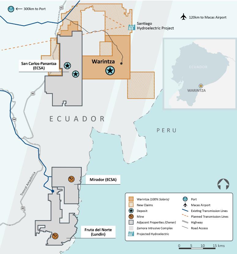
Solaris Resources (TSX: SLS)(NYSE:SLSR) has recently been awarded an option by Empresa Nacional Minera (ENAMI EP), Ecuador’s state-owned mining company, to acquire up to a 100% interest in 10 new exploration concessions. These concessions, covering approximately 40,000 hectares, are strategically located adjacent to the company’s existing Warintza Project and the San Carlos-Panantza porphyry copper-molybdenum deposits within the mineral-rich Zamora belt. This region is known for hosting some of Ecuador’s largest copper and gold mines to the south.
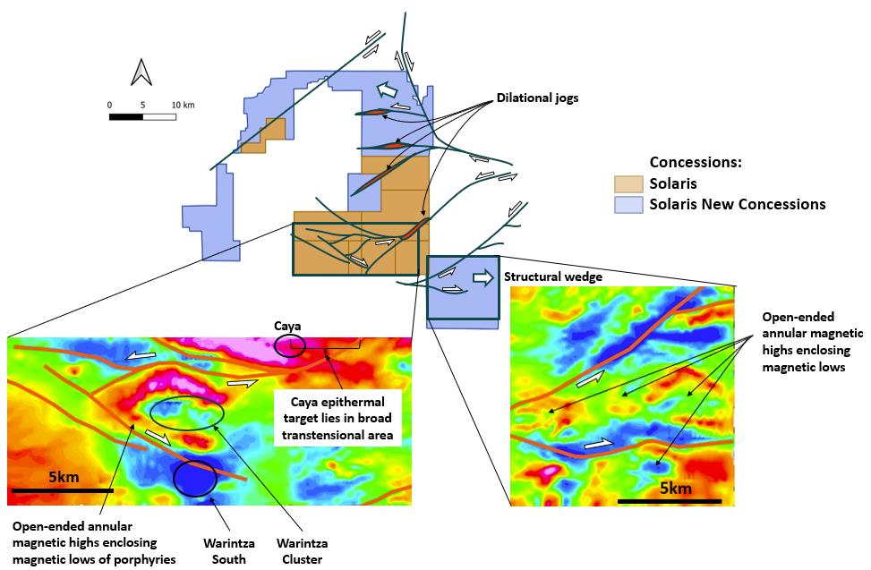
The newly acquired concessions are believed to hold significant potential for porphyry copper and epithermal gold deposits. This assessment is based on a comprehensive analysis of multiple layers of data, including Solaris’ extensive heliborne magnetic survey. The survey results, a portion of which is shown in Figure 2, reveal several promising indicators of mineral deposits.
Porphyry copper targets within the new concessions are characterized by open-ended annular magnetic highs surrounding magnetic lows and erosional depressions. These features are consistent with the outcropping deposits found within the Warintza porphyry cluster, suggesting a high likelihood of mineral presence.
Structural interpretation of the area supports the potential for epithermal gold deposits within dilational jogs and pull-apart basins. These geological settings are common for gold deposits in the Zamora belt and bear similarities to the Caya epithermal target, which was previously announced by Solaris in a press release dated April 23, 2024.
To expedite the exploration process, Solaris plans to deploy two field crews on the ground in May. These teams will begin conducting fieldwork to gather more detailed data and assess the mineral potential of the newly acquired concessions.
The terms of the agreement with ENAMI EP include an upfront payment of US$0.25 million, a proposed exploration program of up to US$25 million over the exploration phase, and the exclusive option for Solaris to acquire the claims from ENAMI EP at a price to be determined by independent experts. This agreement follows similar awards by ENAMI EP to subsidiaries of Barrick Gold Corporation and Hancock Prospecting Pty Ltd, which have committed to investing up to US$148 million in exploration programs in Ecuador.
Solaris’ acquisition of these new exploration concessions demonstrates the company’s commitment to expanding its presence in Ecuador’s thriving mining sector. With the promising potential for porphyry copper and epithermal gold deposits, Solaris is well-positioned to capitalize on the region’s mineral wealth and contribute to the country’s economic growth.
As fieldwork commences and more data becomes available, the mining industry and investors alike will be closely monitoring Solaris’ progress in unlocking the value of these new exploration concessions.
The above references an opinion and is for information purposes only. It is not intended to be investment advice. Seek a licensed professional for investment advice. The author is not an insider or shareholder of any of the companies mentioned above.
Brazil Potash through its wholly-owned subsidiary Potasssio do Brasil, has been granted three additional Installation Licenses (LIs) by the Amazon State Environmental Protection Agency (IPAAM) for the construction of the Autazes Potash Project in Autazes, located 112 km from Manaus. The licenses, issued on April 26th, cover the construction of a river port on the Madeira River, a stockpile at the port, and the drilling of two water collection wells. This brings the total number of LIs issued for the project to four out of an anticipated eleven, with the remaining licenses expected to be granted in the near future.
President of Potássio do Brasil, Adriano Espeschit, commented in a press release: “With Installation Licenses being granted for the mine, port, port stockpile and two water collection wells the Company is ready to start construction activities in the field, with the mobilization of personnel and equipment, within the areas foreseen and approved by the environmental agency.”
The first LI, allowing for the construction of mine shafts and underground workings, was issued on April 8th at an event attended by various government officials, including Amazon State Governor Wilson Lima, IPAAM President Juliano Valente, and representatives from the Mura indigenous people.
The new river barge port, situated near the village of Urucurituba in Autazes, will have a capacity of 2.4 million tons of potash, surpassing the combined capacity of the existing ports in the Northern Arc (Itacoatiara, Vila do Conde, and Santarém), which currently handle around 1.7 million tons of imported fertilizers in the Amazon Basin. The potash produced at the Autazes Potash Project will be primarily targeted at domestic farmers in Brazil.
Potassio do Brasil has complied with the United Nations International Labor Organization Convention (ILO-169), which requires free, prior, informed, and good-faith consultation with indigenous populations. The Autazes Potash Project was approved by more than 90% of the 34 villages out of a total of 36 that comprise the Mura people of Autazes, significantly exceeding the thresholds set by the Mura, which required 60% participation in the vote with support from at least 60% of the people voting.
Following the issuance of the first LI, Brazil Potash has initiated activities to implement the Autazes Potash Project, including the preparation of detailed engineering studies, a comprehensive review of the activity schedule, and quotations for critical path services. The company has also started drilling a second geotechnical hole approximately 1,000 meters deep to gather essential technical information for shaft sinking and construction.
Additionally, Brazil Potash has begun receiving resumes from individuals interested in working on the Autazes Potash Project through a dedicated page on the company’s website. Within three weeks, hundreds of expressions of interest have been received, demonstrating the strong community interest in participating in the project’s construction. Potential suppliers of goods and services can also submit their information through the company’s website, and presentations on the Autazes Potash Project are planned for the coming weeks to facilitate the contracting process for products and services during the construction and anticipated 25-year operation phases.
The above references an opinion and is for information purposes only. It is not intended to be investment advice. Seek a licensed professional for investment advice. The author is not an insider or shareholder of any of the companies mentioned above.
Abitibi Metals (CSE:AMQ) has announced the successful completion of the first phase of its maiden drill program at the B26 Polymetallic Deposit. The drill program, which is part of a larger, fully funded 50,000-metre campaign planned for 2024 and 2025, aims to advance the understanding of the deposit and test its open-pit potential.
The B26 Polymetallic Deposit is located within the renowned Abitibi Greenstone Belt, a region known for its rich history of base and precious metal production, including the Detour and Casa Berardi Mines. The project comprises 66 claims covering an area of 3,328 hectares in the Eeyou Istchee Baie-James territory. Abitibi Metals secured an option agreement with SOQUEM Inc., a subsidiary of Investissement Québec, on November 16th, 2023, which grants the company the right to earn an 80% interest in the project over a period of 7 years.
Jonathon Deluce, CEO of Abitibi Metals, commented in a press release: “We are thrilled with these initial results of our maiden drill program at the B26 Polymetallic Copper Deposit. We had initially planned to drill 2,750 metres but with the continued success in drilling and support from our shareholders, we expanded our maiden program to 13,500 metres, larger than our initial total program for 2024. The significance of this program cannot be understated. Part of our thesis when we optioned B26 was to assess the potential open-pit component that could be added to the historical underground resource. Our strategy for this maiden program was to primarily concentrate on high-priority targets within the Main Deposit to a depth of 300 metres, and the results from #293, #294, #300 and #301, which identified significant near-surface high metal factor zones, support our thesis of assessing the open-pit potential at B26 further. With the recently completed financing bringing our total treasury to approximately $19 million, we are well-positioned to build on this maiden program with a further 36,500 metres to be drilled into 2025. I look forward to sharing the remaining results in the coming weeks as we prepare for the next phase of drilling in the Spring of 2024.”
Phase 1 of the drill program consisted of 44 diamond drill holes, totaling 13,502 metres. This initial phase is part of a larger, fully funded 50,000-metre program that the company plans to complete between 2024 and 2025. Assay results from the first 10 holes have already been released, with results from the remaining 34 holes expected to be announced in the coming weeks, once the data has been received and compiled.
Abitibi Metals’ strategy for developing the B26 Deposit in 2024 is centered around five key milestones:
- Expansion of the Drill Program: Building upon the 13,500 metres completed in Phase 1, the company plans to drill an additional 16,500 metres in 2024, contributing to the overall goal of 50,000 metres by 2025.
- Updating the Internal Resource Estimate and 3D Geological Model: The company recently announced its first 3D model of the project, which integrates data from the maiden drill program with over 115,000 metres of historical drilling conducted by SOQUEM. This updated model represents a significant advancement in understanding the geological controls of mineralization within the deposit and is expected to improve confidence in an updated internal mineral resource estimate currently underway.
- Conducting a Gravity Survey: To further enhance the understanding of the deposit’s geology, Abitibi Metals plans to conduct a Gravity Survey grid covering extensions of the VMS contact. This survey will help model the mafic-felsic contacts and sulphide-rich environment, aiding in the targeting of new mineralized extensions and satellites at shallow to moderate depths (300 to 600 metres). The company believes that an integrated geophysics approach could lead to additional discoveries on the property.
- Evaluation of Assay Preparation Protocols: Addressing the recommendations made by SGS in the 2018 resource estimate, Abitibi Metals has implemented a series of assaying protocols to control QAQC issues from the outset of the project. These adjustments include finer crushing of samples (95% passing 1.7 mm) and pulverizing a larger 1 kg split down to 106 µm (150 mesh). The company believes these measures will help to better evaluate higher-grade areas of the deposit, as demonstrated by the results of drillhole 1274-24-293, which highlight the potential for grade increases within specific areas.
- Assaying Historical Unassayed Core: The 2018 resource estimate by SGS identified 8,300 metres of historical unassayed core within the mineralized corridor. Abitibi Metals intends to assay these identified areas to refine the deposit model and better delineate the boundaries of the mineralization.
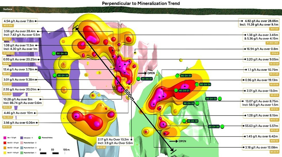
In addition to the ongoing work at the B26 Deposit, Abitibi Metals is also conducting drilling at the nearby Beschefer Gold Project, located just 7 km to the northeast. As of April 22, 2024, the company has completed 5 holes totaling 1,679 metres in the East Zone, which has historically yielded high-grade gold intercepts, including 55.63 g/t gold over 5.57 metres and 13.07 g/t gold over 8.75 metres. The company is on track to complete a total of 2,975 metres across 10 holes at the Beschefer Project.
The B26 Polymetallic Deposit represents a significant opportunity for Abitibi Metals to develop a copper, zinc, gold, and silver resource in a region with a rich mining history. The deposit has a strike length of 1 km and a depth extent of 0.8 km, both of which are open to expansion. With year-round road access and a power line running through the project, Abitibi Metals is well-positioned to advance the exploration and development of this promising asset.
As the first public company to have the option to earn into the B26 Deposit, Abitibi Metals is committed to delivering shareholder value through an aggressive exploration approach. The fully financed 50,000-metre drill program, spanning 2024 and 2025, will focus on advancing the historical 2018 resource while simultaneously testing the deposit’s open-pit potential.
With the successful completion of Phase 1 drilling and assay results pending for the remaining 34 holes, Abitibi Metals is poised to make significant strides in understanding the B26 Polymetallic Deposit. The company plans to recommence drilling activities in early June, once the winter break-up concludes and Phase 2 targeting is finalized. As the exploration program progresses, investors and stakeholders can expect regular updates on the company’s advancements and discoveries at this exciting project in the heart of the Abitibi Greenstone Belt.
Highlights from the results are as follows:
- B26 Main Deposit: 36 holes were completed, totalling 10,469.5 metres, to evaluate the open pit potential and potential up-dip near-surface extensions of the Main Deposit to the north and infill gaps in the model.
- Satellite West: 5 holes were completed, totalling 1,716 metres, targeting the geometric continuity of a potential satellite zone 500 metres to the west of the Main Deposit.
- Eastern Extension: 3 holes were completed, totalling 1,317 metres, targeting the expansion of the main deposit to the east where 2.45% Cu Eq over 26.7 metres, including 4.74% CuEq over 11.7 metres (1274-14-167) was intercepted in historical drilling.
- Phase 1 highlight intervals to date include:
-
- #1274-24-293: 2.6% CuEq over 37.0 metres beginning at 106 metres depth, including 6.3% CuEq over 10.6 metres
- #1274-24-294: 2.5% CuEq over 61.3 metres beginning at 128.6 metres depth, including 11.4% CuEq over 10.6 metres
- #1274-24-300: 5.35% CuEq over 8.1 metres beginning at 251.5 metres depth
- #1274-24-301: 1.47% CuEq over 97.5 metres beginning at 30.5 metres depth, including 3.9% CuEq over 21.9 metres
- Historical 2018 resource prepared by SGS Canada Inc. for SOQUEM Inc. that includes 254 holes over 115,311 meters, advancing the asset to a significant resource that includes, across all categories, 400 million pounds of copper, 286,000 ounces of gold, and significant zinc silver exposure.
- B26 Historical Resource Summary1 (2018)
-
- Indicated: 6.97 Mt at 2.94% Cu Eq (1.32% Cu, 1.80% Zn, 0.60 g/t Au and 43 g/t Ag)
- Inferred: 4.41 Mt at 2.97% Cu Eq (2.03% Cu, 0.22% Zn, 1.07 g/t Au and 9 g/t Ag)
- Historical drilling by SOQUEM has established the continuity down to a vertical depth of 800 meters and the deposit remains open at depth and laterally with strong historical intercepts including:
-
- 2.32% Cu Eq over 89.5 metres (1274-13-117)
- 3.05% Cu Eq over 48.1 metres (1274-16-224)
- 8.95% Cu Eq over 11.5 metres (1274-14-152)
- The B26 deposit is situated within 7 km of the historical Selbaie Mine, a Polymetallic Deposit with a variety of mineralization styles and element combination, that had a historical resource of 56.9 Mt @ 0.87% Cu, 1.85% Zn, 0.55 g/t Au, 39 g/t Ag (CONSOREM 2012). Reference to this nearby property is for information only, and there are no assurances that the Company will achieve the same results at the B26 Deposit.
The above references an opinion and is for information purposes only. It is not intended to be investment advice. Seek a licensed professional for investment advice. The author is not an insider or shareholder of any of the companies mentioned above.
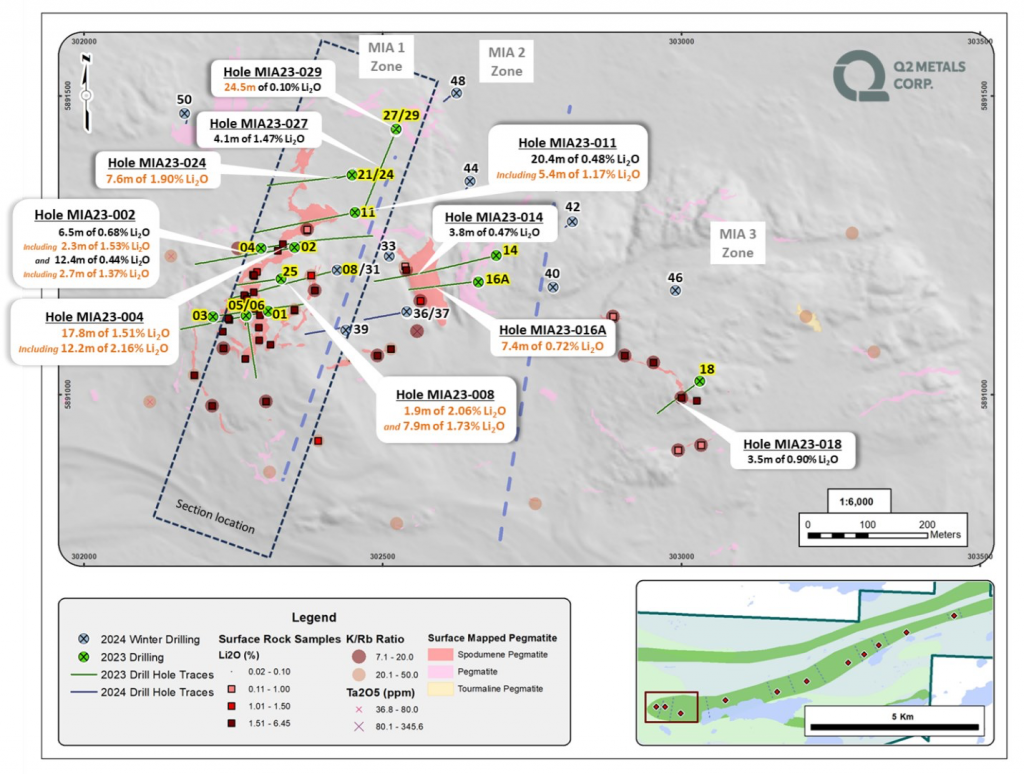
Q2 Metals (TSXV:QTWO) recently reported the core assay results from its first drill program, which took place in the fall of 2023 at its wholly owned Mia Lithium Property in the Eeyou Istchee James Bay Territory of Quebec. The property spans over 8,668 hectares.
The inaugural drilling focused on the Mia Lithium Exploration Trend, approximately 10 kilometers long, situated 22 kilometers from the Billy Diamond Highway. This location is near major hydro-powerline and all-season road infrastructure, enhancing the site’s accessibility and potential development viability.
Neil McCallum, VP Exploration, commented in a press release: “Core assay results received to date indicate our 2023 drill program was successful in confirming spodumene mineralization in the pegmatites at the Mia Property. Using innovative targeting methods, our 2023 drill program on the Mia Trend has revealed that pegmatites are in some cases complex and variably mineralized at depth and in other cases, such as at Mia-1/2 and Carte, the pegmatite bodies have a simple geometry and consistent mineralization. We are very encouraged with these first drill results and believe we have only just begun to unlock the potential of the Mia Property.”
The Mia Trend features a series of sub-parallel pegmatite intrusions, including 11 zones where spodumene mineralization has been demonstrated. These pegmatite bodies vary significantly in thickness, ranging from a few meters to more than 20 meters in some instances.
The drilling campaign involved 31 drill holes totaling about 5,601 meters. Operations were conducted using two rigs; one rig focused on the main Mia 1, 2, and 3 zones, drilling 17 holes, while the other rig worked on the Carte Zone with eight holes and tested other parts of the Mia Trend with six holes across zones Mia 7, 8, and 9.
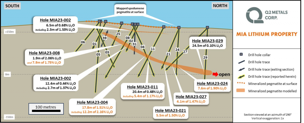
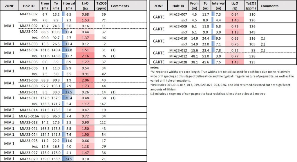
The most significant findings came from the Mia Zone, where the pegmatite zone showed continuous spodumene mineralization. This zone is characterized by a gentle northward dip, with mineralization thickness ranging between 8 and 20 meters. The pegmatite extends approximately 600 meters east-west and about 375 meters north-south, and it remains open to expansion to the west, east, and north.
In the Carte Zone, drilling confirmed spodumene mineralization as well. The mineralized pegmatite in this area surfaces and dips gently to the northwest. It ranges from 5.8 to 7.3 meters in thickness and stretches approximately 170 meters in a northeast-southwest direction, with intersections down to a depth of about 65 meters.
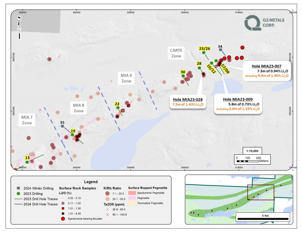
These findings underscore the potential for additional discoveries within the larger Mia Trend, considering the wide spacing of between 500 meters and 2.8 kilometers between drill holes. This initial exploration suggests the presence of significant lithium-bearing mineral resources, which could play a crucial role in supporting the growing demand for lithium, primarily driven by the electric vehicle and battery storage markets.
Highlights from the results are as follows:
- Confirmed presence of wide spodumene-mineralized pegmatites containing high grade intervals at the Mia and Carte zones:
- Mia Zone – 17.8 m at 1.51% Li2O, including 12.2 m of 2.16% Li2O (MIA23-004)
- Carte Zone – 7.3 m at 0.94% Li2O, including 4.4 m of 1.40% Li2O (MIA23-007)
- Continuity of mineralization at the Mia 1 & 2 zones.
- Core assay results remain to be reported for the 20 drill holes from the Company’s approximately 3,085 m Winter 2024 Drill Program.
The above references an opinion and is for information purposes only. It is not intended to be investment advice. Seek a licensed professional for investment advice. The author is not an insider or shareholder of any of the companies mentioned above.
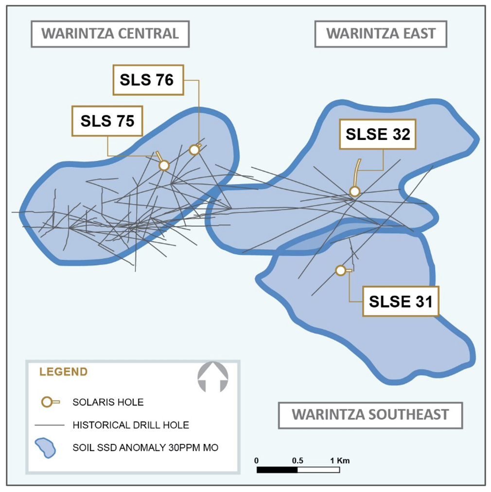
Solaris Resources (TSX:SLS) (NYSEAMERICAN:SLSR) has shared the initial results from its 2024 drilling efforts and provided an update on exploration at its Warintza Project in southeastern Ecuador. These early results include intersections of 150 meters of 0.67% copper equivalent (CuEq) within a broader section of 384 meters of 0.51% CuEq, and another segment measuring 284 meters of 0.53% CuEq starting near the surface.
The drilling operations, which intensified during the first quarter despite the rainy season, are part of a large-scale plan to both expand and upgrade the mineral resources at the project. With six rigs currently operating across multiple zones including Warintza Central, East, and Southeast, the company expects the drilling to continue throughout the year. This effort is also accompanied by exploratory drilling at the newly discovered Patrimonio site and regional exploration at the promising Caya epithermal gold target.
In terms of the 2024 drilling campaign specifics, January saw 700 meters drilled, which increased to 1,800 meters in February and 3,800 meters in March. The company anticipates reaching 5,200 meters by the end of April. Overall, Solaris plans to complete at least 30 kilometers of drilling this year, with an updated report on mineral resources expected by the end of June.
Solaris has secured the necessary funds for its 2024 and 2025 exploration programs through an offtake financing package announced in December last year. As of the end of 2023, the company reported having around US$39 million in cash and equivalents. It expects an additional US$40 million from its financing activities, further bolstered by a strategic investment finalized in January 2024. However, the details of this investment are still under review by Canadian regulators.
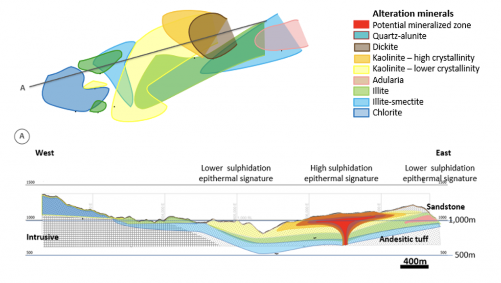
In addition to its drilling program, Solaris is also focusing on the Caya epithermal gold target. Recent field work at this site has highlighted a 5 km by 3 km gold anomaly located northeast of Warintza East. Soil samples have outlined a significant area of gold and other pathfinder elements indicative of epithermal mineral deposits. The alteration patterns and mineral assemblages found at Caya suggest a high-sulfidation epithermal system, a style of mineralization known for hosting significant gold deposits.
The exploration team has recently expanded its soil sampling grid to include areas affected by historical artisanal mining, which could offer insights into the broader mineral potential of the region. The company plans to use additional spectral analysis to better understand the alteration patterns in the volcanic sediment layers covering the target area. Further details on these findings are expected to be reported in June.
Highlights from the results are as follows:
- SLS-76 was collared on the northeastern limit of the Northeast Extension zone and drilled northwest, returning 150m of 0.67% CuEq¹ within a broader interval of 384m of 0.51% CuEq¹, before the hole was terminated in lower grade mineralization
- SLSE-31 was collared on the southern margin of Warintza Southeast and drilled east to the ~300m depth capacity of the KD-200 rig, returning 284m of 0.53% CuEq¹ from near surface, with the final 10m averaging 0.75% CuEq¹ and remaining open for extension drilling with a larger rig
- SLS-75, drilled northeast from a new 200m step-out platform at Northeast Extension zone, returned 26m of 0.52% CuEq¹ and 46m of 0.66% CuEq¹ within a low-grade section from surface with a post-mineral dyke before a final 62m mineralized interval averaging 0.51% CuEq¹
- SLSE-32 was collared on the northern margin of Warintza East and drilled north, returning 380m of 0.31% CuEq¹ from surface within a broader interval of 634m of 0.27% CuEq¹ where the hole cut the contact of the primary host lithology with bordering lower grade volcanic rock
- Exploration drilling is underway at Patrimonio to follow up on the discovery holes (144m of 0.50% CuEq¹ and 148m of 0.52% CuEq¹, respectively – refer to press release dated September 12, 2023) while field crews expand sampling coverage over the highest grade part of the anomaly to the south and down-dip of the replacement mineralization to locate the potential porphyry source
- Regional exploration programs are underway at the promising Caya epithermal gold target, located 6km to the northeast of Warintza East, where field crews are expanding sampling and alteration mapping to the west to cover an area where evidence of historical artisanal mining has been identified
- Funded for 2024 and 2025 programs with the offtake financing package announced in December, with plans to aggressively expand activities and consolidate the surrounding district with funds from closing the strategic investment announced in January
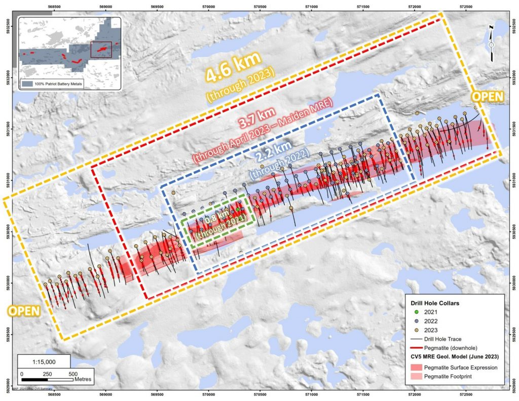
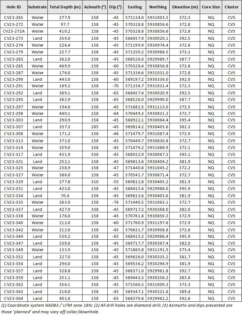
Patriot Battery Metals (TSX:PMET) has reported detailed results from its 2023 drilling activities at the CV5 Spodumene Pegmatite located on its wholly owned Corvette Property in the Eeyou Istchee James Bay region of Quebec. The Corvette Property lies approximately 13.5 km south of the Trans-Taiga Road and powerline infrastructure, an advantageous position for logistical support.
In 2023, the company completed drilling in 42 new holes at the CV5 Spodumene Pegmatite, which previously had a maiden mineral resource estimate (MRE) of 109.2 million tonnes at 1.42% Li2O. These holes included both infill drilling aimed at increasing the density of data within the previously drilled area and new drills that extended the known area of the pegmatite body. By the end of the year, the pegmatite had been traced over a strike length of 4.6 km. Notably, this pegmatite remains open for further exploration both along its strike and at depth.
Darren L. Smith, Vice President of Exploration for the Company, commented in a press release: “The 2023 drilling at CV5 has more than doubled the spodumene pegmatite’s strike from 2.2 km at the end of 2022, to 4.6 km at the end of 2023 and remains open. To put this further into perspective, the maiden mineral resource estimate for CV5 – announced July 2023 – covered only ~3.7 km of this strike length and highlights the deposit’s growth potential over time. While much work has been done, in many respects it feels like we are only just beginning to unlock the potential at Corvette.”
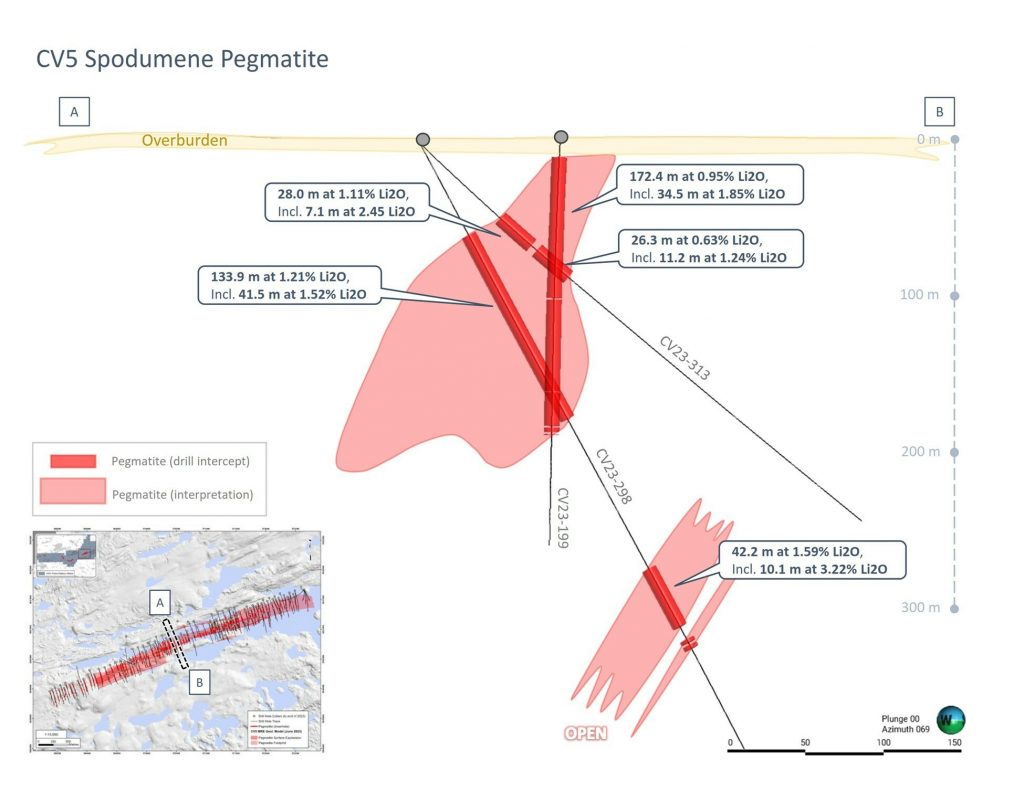
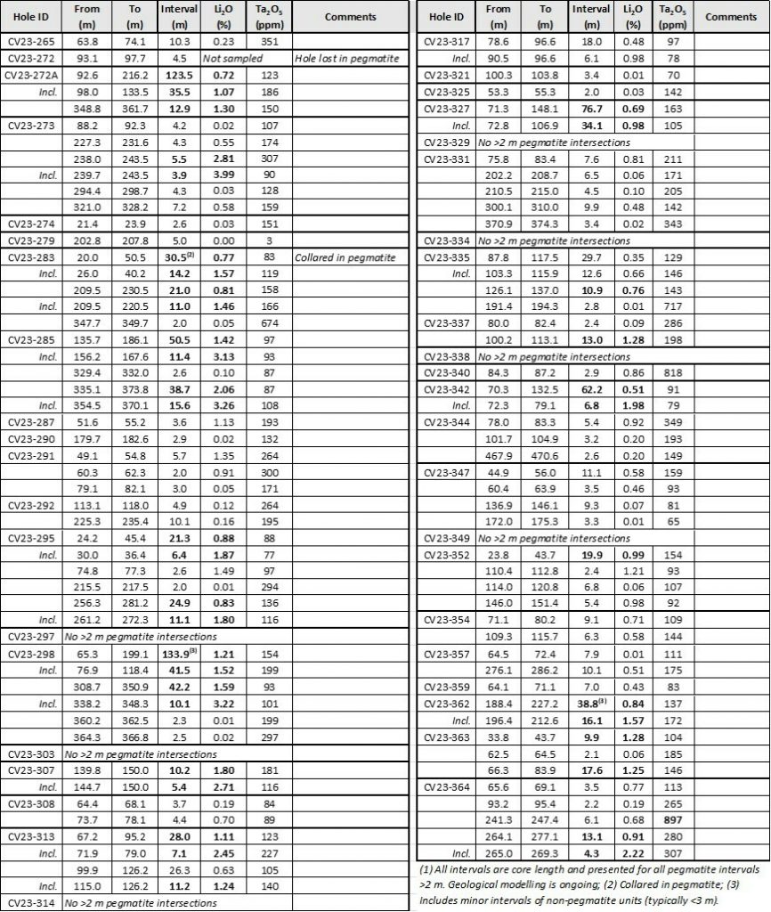
The drilling results highlighted several areas of very high-grade lithium concentrations. Specifically, drill holes CV23-298 and CV23-285 returned significant sub-intervals with grades of 3.22% Li2O over 10.1 meters and 3.26% Li2O over 15.6 meters, respectively. These high-grade results are crucial as they confirm the central area of CV5’s potential outside of the previously identified Nova Zone.
Further west, the primary pegmatite body appears to have split into two sub-parallel trending bodies, both showing ongoing mineralization. This includes a drill result from hole CV23-273, which found 3.9 meters at 3.99% Li2O, and from the most westerly hole drilled in 2023, CV23-364, which returned 13.1 meters at 0.91% Li2O, including a higher-grade section of 4.3 meters at 2.22% Li2O.
The proximity of CV5 and another pegmatite on the property, CV13, which are now known to be approximately 2.9 km apart, represents a prospective corridor that has yet to be fully tested by drilling. This corridor is also aligned with a local structural and magnetic trend, adding to its prospectivity.
Overall, in 2023, the company drilled a substantial 78,213 meters across the property, focusing largely on CV5 and CV13. The results from the winter 2024 drill program, which included 62,518 meters of drilling, are still pending. This program aimed to continue detailed exploration and data collection, particularly at CV5, to upgrade the resource classification from inferred to indicated, thereby enhancing the project’s potential for development.
Looking ahead, Battery Metals Inc. plans to release an updated MRE for the Corvette Project by the third quarter of 2024. This update will incorporate all drilling data up to April 2024 and is expected to boost confidence in the resource estimates at both CV5 and CV13, supporting ongoing development studies. The forthcoming MRE update aims not just to integrate new data but to advance the resource category at CV5, a step forward in moving the project towards development.
Highlights from the results are as follows:
- Strong assay results over wide intervals from infill drilling at CV5.
- 133.9 m at 1.21% Li2O, including 41.5 m at 1.52% Li2O; and 42.2 m at 1.59% Li2O, including 10.1 m at 3.22% Li2O (CV23-298).
- 50.5 m at 1.42% Li2O, including 11.4 m at 3.13% Li2O; and 38.7 m at 2.06% Li2O, including 15.6 m at 3.26% Li2O (CV23-285).
- High-grade intercepts at CV23-298 and 285 are located further west and outside of the previously delineated Nova Zone.
- Assays and the continuity of mineralization along CV5’s western extension are encouraging and situated outside of the June 2023 mineral resource estimate (“MRE”).
- 30.5 m at 0.77% Li2O, including 14.2 m at 1.57% Li2O; and 21.0 m at 0.81% Li2O, including 11.0 m at 1.46% Li2O (CV23-283) – collared in pegmatite.
- 21.3 m at 0.88% Li2O, including 6.4 m at 1.87% Li2O; and 24.9 m at 0.83% Li2O, including 11.1 m at 1.80% Li2O (CV23-295).
- Through 2023, CV5 mineralization has been traced by drilling over a 4.6 km strike length and remains open along strike at both ends and to depth.
- The 2024 winter drill program (now complete), totaled 62,518 m (166 holes), including 50,961 m (121 holes) at CV5, and 11,557 m (45 holes) at CV13 (with first assays to be reported shortly).
- Since discovery (fall 2021) through to the recently completed 2024 winter drill program, the Company had completed 134,129 m (369 holes) at CV5, of which only 56,461 m (166 holes) were included in the June 2023 MRE.
- An updated MRE in Q3 2024 will focus on upgrading the resource category at CV5 and include a maiden resource at CV13, incorporating all drilling through to April 2024.
- 133.9 m at 1.21% Li2O, including 41.5 m at 1.52% Li2O; and 42.2 m at 1.59% Li2O, including 10.1 m at 3.22% Li2O (CV23-298).
- 50.5 m at 1.42% Li2O, including 11.4 m at 3.13% Li2O; and 38.7 m at 2.06% Li2O, including 15.6 m at 3.26% Li2O (CV23-285).
- 123.5 m at 0.72% Li2O, including 35.5 m at 1.07% Li2O; and 12.9 m at 1.30% Li2O, (CV23-272A).
- 76.7 m at 0.69% Li2O, including 34.1 m at 0.98% Li2O (CV23-327).
- 30.5 m at 0.77% Li2O, including 14.2 m at 1.57% Li2O; and 21.0 m at 0.81% Li2O, including 11.0 m at 1.46% Li2O (CV23-283) – collared in pegmatite.
- 21.3 m at 0.88% Li2O, including 6.4 m at 1.87% Li2O; and 24.9 m at 0.83% Li2O, including 11.1 m at 1.80% Li2O (CV23-295).
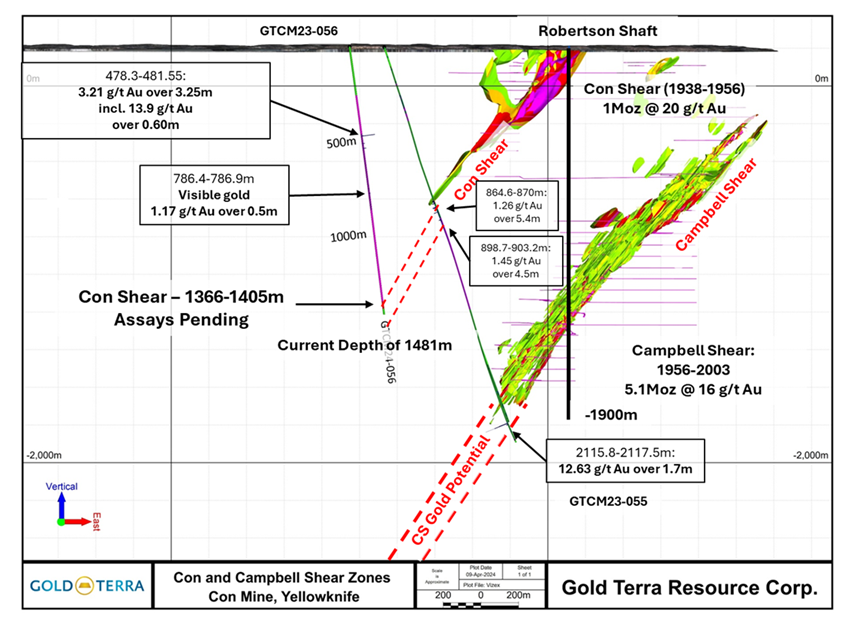
Gold Terra Resource Corp. (TSXV:YGT) has reported details on the progress of deep drilling operations at the Con Mine. The focus of the reported results includes drill hole GTCM24-056, initiated in early February, aiming at the Campbell Shear below the Con Mine workings, which historically produced over 5.1 million ounces of gold at an average grade of 16 grams per tonne. Notably, the drilling intersected the Con Shear, a secondary shear structure with historical production figures of 1 million ounces at 20 grams per tonne gold, between depths of 1366 and 1405 meters, as outlined in the company’s October 21, 2022, technical report.
Chairman and CEO, Gerald Panneton, commented in a press release: “Hole GTCM24-056 is now progressing well on its way to intersecting our prime target, the Campbell Shear, which produced 5.1 million ounces of gold at an average grade of 16 g/t. The Con shear intersection and the gold bearing quartz veining in the granite higher up in GTCM24-056 confirm the untested endowment of gold in this hanging wall area. The under-explored Campbell Shear and subsidiary shear zones such as the Con shear illustrate the large potential to find multiple gold deposits in gold camps such as Timmins, Red Lake, Cadillac/Larder Lake and Val d’Or, and as in these most prolific and highest-grade gold camps, that component is what attracted Gold Terra to explore this highly potential area.”
This particular hole uncovered new gold mineralization with concentrations up to 13.90 grams per tonne over a 0.60-meter section within the granite host rock of the Con Shear at multiple depths ranging from 478.30 meters to 546 meters and again at 748 meters. The exploration took place on the Con Mine Option Property (CMO), located about one kilometer west of the primary Campbell Shear target. As per the conditions outlined in the property option agreement with Newmont Corporation, Gold Terra has an option to fully acquire the CMO Property.
The intersection with the Con Shear featured intense silicification of mafic volcanic and intermediate intrusive rocks, with a substantial quartz vein present at the contact zone. The sheared zones exhibited a mix of white to smoky grey quartz veins filled with pyrite, with shearing noted as intermittent but notably strong where present.
Gold Terra’s exploration drilling began in volcanic rocks before reaching a granitic intrusive from 261 meters down to 1340 meters. This zone is believed to represent a mineralized stock adjacent to the historical Con Mine gold systems, a feature common in the Yellowknife Greenstone Belt. The granitic zone showed varied quartz vein densities with associated siliceous alteration and scattered mineral occurrences including pyrite, arsenopyrite, sphalerite, galena, pyrrhotite, and tourmaline.
Assays from this granitic host have reported significant gold values from the intervals between 478 and 546 meters, with further samples currently being analyzed to ensure comprehensive evaluation. As the drill continues to deeper levels, results up to a downhole depth of 875 meters have been processed, while deeper samples remain pending.
This drilling effort is part of a larger 2024 campaign aiming to expand upon the initial Mineral Resource Estimate (MRE) reported in September 2022, which accounted for 109,000 ounces of indicated gold and 432,000 ounces of inferred gold up to 400 meters below the surface along a two-kilometer stretch of the Campbell Shear. This MRE is detailed in the October 2022 technical report available on Gold Terra’s website and SEDAR.
The report also mentioned the Yellowknife Lithium Project (YLP), noting that exploration activities in 2023 led to the identification of several spodumene-bearing pegmatites with lithium grades reaching up to 4.2% Li2O. However, Midas Minerals Ltd (ASX:MM1) has decided to withdraw from the corresponding option agreement with Gold Terra.
Highlights from the results are as follows:
| Hole ID | From (metres) | To (metres) | Length (metres) | g/t gold (Au) | ||
| GTCM24-056 | 476.30 | 481.55 | 3.25 | 3.21 | ||
| GTCM24-056 | Incl. | 479.80 | 480.40 | 0.50 | 13.90 | |
| GTCM24-056 | 510.20 | 520.50 | 1.30 | 1.23 | ||
| GTCM24-056 | 544.00 | 546.00 | 2.00 | 2.17 | ||
| GTCM24-056 | Incl. | 545.50 | 546.00 | 0.50 | 6.89 | |
Solaris Resources (TSX:SLS)(NYSEAmerican:SLSR) and the Shuar communities of Warints and Yawi have recently signed an updated Impact and Benefits Agreement (IBA) for the Warintza Project. This agreement signifies a step forward in the project’s evolution, reflecting its continued growth and advancement.
The IBA is a key part of Solaris’ Community Social Relations (CSR) program, recognized as a leading practice within the Ecuadorian mining industry. It guarantees the Shuar communities’ backing for Warintza throughout all stages, from exploration and development to production. Importantly, the agreement also formalizes commitments to several key areas.
First, that Solaris Resources will uphold the social and cultural practices of the Shuar communities. Second, the company will take steps to minimize or eliminate any negative impacts the project may have. This could include environmental or social disruptions. To maximize community participation in the project, Solaris will provide opportunities for employment, education, and skills training. The agreement also includes financial benefits for the Shuar communities.
The Warintza Project is expected to deliver significant advantages to local communities. These include job creation and business development opportunities. The project will also improve access to appropriate healthcare, including emergency services. Additionally, the agreement includes measures to develop community infrastructure and provide educational and skills training programs.
The updated IBA also fosters greater involvement from the Shuar communities in the project’s development. This collaboration establishes a framework to address shared concerns regarding the project’s impact on their lives and the well-being of their communities.
Beyond local benefits, the Warintza Project is anticipated to generate tax revenue for the Ecuadorian government. Solaris has reiterated its commitment to operating sustainably and responsibly by minimizing environmental impact and maintaining open communication with local communities.
Ms. Sonsoles García, Minister of Production, Foreign Trade, Investment and Fisheries, commented, “We value this initiative of Solaris because it strengthens positive community relations and provides for the integration of the local population in productive and sustainable activities. This allows the inclusion of a traditionally displaced population, which is a priority for us. It is also aligned with the priority we have as a National Government of territorial development and good use and management of resources.”
Mr. Daniel Earle, President & CEO, commented, “The signing of this updated IBA builds on the foundation of good faith dialogue and trust that led to the formation of a Strategic Alliance partnership with our host communities and original IBA in 2020. This marks a significant milestone in the social advancement of the Warintza Project through our pioneering Participatory Mining model for sustainable resource development.”
Mr. Agustin Kayuk, leader of the Shuar Warints Center and member of the Board of Directors of the Strategic Alliance, commented, “The signing of this updated IBA strengthens the working relationship with Solaris and brings greater opportunities for the development of our communities. The decision is supported by a permanent relationship with the Company based on mutual respect and transparent dialogue, as well as a history of positive impacts generated for our people. We look forward to continuing our relationship and playing an integral role in the advancement of the Project.”
Mr. Vicente Froilan Juank, leader of the Shuar Yawi Center and also a member of the Board of Directors of the Strategic Alliance, commented, “The updated IBA brings further support and new opportunities for our people. When Warintza advances, our communities advance with it. Since the signing of the inaugural IBA in 2020, and with the help of the Ecuadorian state, the local impacts in job creation, community infrastructure, and development of programs in health, education, skills training, entrepreneurship, and innovation have been evident in our daily lives.”
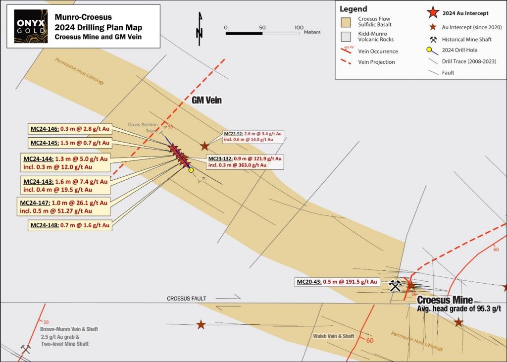
Assay Results for GM Vein
- 26.09 g/t Au over 1.0 m in hole MC24-147, including
- 51.27 g/t Au over 0.5 m
- 7.39 g/t Au over 1.6 meters in hole MC24-143, including
- 19.46 g/t Au over 0.4 m
- 5.00 g/t Au over 1.3 meters in hole MC24-144, including
- 11.98 g/t Au over 0.3 m
Table 1 – Assay Results From First 6 Holes Completed At The GM Vein
| Drill Hole | From (m) |
To (m) |
Length (m) |
Au (g/t) |
| GM Vein Discovery | ||||
| MC24-143 | 52.90 | 54.50 | 1.60 | 7.39 |
| Including | 53.20 | 53.60 | 0.40 | 19.46 |
| MC24-144 | 50.60 | 51.90 | 1.30 | 5.00 |
| Including | 51.30 | 51.60 | 0.30 | 11.98 |
| MC24-145 | 48.80 | 50.30 | 1.50 | 0.68 |
| MC24-146 | 48.50 | 48.80 | 0.30 | 2.84 |
| MC24-147 | 57.70 | 58.70 | 1.00 | 26.09 |
| Including | 58.20 | 58.70 | 0.50 | 51.27 |
| MC24-148 | 60.40 | 61.10 | 0.70 | 1.59 |
| *Note — Drill Intercepts are 70-100% of true width. Averages are length-weighted using a 0.5 g/t gold cut-off and a maximum of 10 m of internal dilution. Ian Cunningham-Dunlop, P.Eng., Executive vice president for Onyx Gold and a qualified person as defined by Canadian National Instrument 43-101, has reviewed and verified the information within this table. | ||||
Bank of America (BofA) analysts are bringing attention to a shift in the copper market. According to them, copper prices are set to rise substantially by 2026. The expected increase is due to the metal’s decoupling from traditional market cycles, driven by the global energy transition and technological advancements. This phenomenon should see copper stop following the broader commodity market trends in the coming quarters and hold on to a bullish trend in the coming years.
The April 8, 2024 report by BofA, co-authored by commodity strategist Michael Widmer, points out the central issue of tight copper mine supply which is putting a strain on refined production. There are not enough new mine projects to meet the demand, and this is starting to have a noticeable effect on the market. The primary concern highlighted in the report is the increasing cost of capital for mines and the slow pace at which copper prices are catching up. These factors are pushing copper into a significant market deficit, expected to reach 324,000 tonnes this year, and growing to a massive 743,000 tonnes by 2026.
Currently, copper prices are already showing a sharp increase. Over just two months, the price surged by over 15% to $9,419.50 per tonne as of April 8, nearing a 15-month high. This uptick follows disruptions in mine production that led to the shutdown of refined copper capacity at several Chinese smelters, which account for a substantial part of global production. As of the latest trading, copper was at $9,363 per tonne. The record price for copper was set in May 2021 when it hit $10,747.50 per tonne. This peak was due to intense demand from China coupled with supply disruptions caused by the COVID-19 pandemic. Despite these potential supply issues, the demand for copper is only growing. This is driven by investments in green technologies, a recovering global economy, the restocking of supplies, and the anticipation of potential rate cuts.
The relevance of copper in renewable energy technologies, electric vehicles (EVs), and infrastructure development is particularly critical. Its essential role in these areas makes it a key component in the shift towards a more sustainable global economy. The reliance on copper for these technologies exacerbates the impact of any supply shortfalls. BofA has also pointed out China’s considerable influence in the copper market, emphasizing that the country’s investment decisions, especially regarding green technologies, have a substantial effect on global copper demand. However, even if China were to reduce its green investments, which could theoretically ease demand pressures, the supply constraints would still drive bullish price trends.
The forecast from Bank of America has raised the alarm for the mining industry, which is currently facing the dual challenge of meeting the growing demand for copper while contending with increased capital costs and supply constraints. The projected deficits and surging prices are a wake-up call for an industry that must balance the urgency of exploration and development with the financial realities of bringing new mines online.
The impact of these market dynamics is far-reaching. Mining companies are now under immense pressure to ramp up exploration and fast-track the development of new mines. However, exploration is a time-intensive and risky investment, with no guarantee of discovery. It involves extensive geological surveys, regulatory hurdles, and significant capital before any potential returns can be realized. The industry is also grappling with aging mines, where the easy-to-reach copper has already been extracted. This require more sophisticated and expensive extraction techniques to tap into lower-grade ores.
Companies might need to invest more in technology that can improve the efficiency of existing operations, reduce the environmental impact, and potentially discover new deposits. This might include the use of artificial intelligence in geological data analysis, remote sensing technologies for exploration, and automation in mining operations. The forecasted rise in copper prices also has the potential to reshape the geographic landscape of copper mining. Countries that have untapped copper resources may find themselves at the forefront of new mining endeavors, which could shift the current centers of copper production.
For now, traders will be watching copper futures closely for signs of any change or acceleration in momentum, and over the long-term, investors have already begun moving back into copper exploration equities as they have bottomed out since the market sell-off in early 2023.
Standard Uranium (TSXV:STND) has recently completed its first round of drilling at the Atlantic Project, located in the eastern Athabasca Basin, northern Saskatchewan. The project spans over 3,061 hectares and initial reports indicate that all drill holes showed signs of anomalous radioactivity. This area is known for its uranium potential, hosting numerous occurrences of the element along an 18 km east-west trending conductive exploration trend.
Sean Hillacre, Standard Uranium’s VP of Exploration, commented in a press release: “Intersecting anomalous radioactivity across all five drill holes targeting a completely untested area on the Atlantic project is extremely encouraging. The results from this program have confirmed the presence of a significant structural framework on the property providing the ideal conditions for high-grade unconformity-related uranium mineralization. The scale and intensity of deformation in the basement rocks we drilled this season is highly prospective and paired with the radioactivity and hydrothermal alteration intersected in the overlying sandstone, we are just in the beginning of uncovering the compelling story on the first of many target areas on Atlantic.”
The drilling was part of a partnership with ATCO Mining Inc., which holds the option to acquire a 75% interest in the Atlantic Project over the next three years. This recent drilling activity is part of the effort to meet the first year’s minimum exploration expenditure as required under the terms of the option agreement.
In 2022, a detailed ground gravity survey was conducted on the western portion of the claim block, which identified multiple subsurface density anomalies. These anomalies suggest the presence of significant hydrothermal alteration zones, potentially important for uranium deposition. These findings led to the targeted drilling activities this winter.
The drill program specifically aimed to follow up on findings from a 2016 drill hole by Denison Mines, which had identified significant uranium mineralization. This winter’s drilling focused on a region defined by a large density-low anomaly, which coincides with electromagnetic (EM) conductors and a regional fault, all suggesting a highly prospective target area for uranium.
The samples collected from the drilling have been sent to SRC Geoanalytical Laboratories in Saskatoon for a comprehensive range of tests including multi-element analysis and uranium assays. The laboratory, recognized for its adherence to international standards, also tested for additional elements like boron and performed specialized assays to determine the uranium content directly.
To ensure the accuracy and reliability of the assay results, Standard Uranium implemented rigorous quality assurance and quality control measures, including the insertion of blanks, standard reference materials, and repeat samples into the testing sequence.
Moreover, samples showing clay alteration have been forwarded to Rekasa Rocks Inc. for advanced analysis using Short Wavelength Infrared Reflectance. This will help in identifying the specific types of clay minerals present, which is critical in understanding the geochemical environment of the uranium mineralization.
The results of these geochemical assays are eagerly awaited and will be disclosed following a detailed review by Standard Uranium’s technical team. This ongoing work at the Atlantic Project is a crucial step in exploring and potentially developing this promising uranium resource in Saskatchewan.
Neil McCallum, director of Standard Uranium and Atco Mining, also commented: “I am very encouraged with the magnitude of the structure and alteration that has been encountered thus far. Combined with the anomalous radioactivity, we’re setting the stage for more success on the project. We are already planning the next steps, so having this information will be an incredible addition to our exploration model.”
Highlights from the results are as follows:
- Inaugural Success: Anomalous radioactivity (>300 cps) was intersected in all five of the Company’s inaugural drill holes at the Atlantic Project, coinciding with prospective structural zones and favorable alteration including dravite-rich clays.
- Sandstone & Basement-Hosted Radioactivity: Multiple zones of elevated radioactivity linked to the sub-Athabasca unconformity and basement structural zones were intersected, indicating a uranium-fertile system.
- Verified Targets: Massive structural disruption confirmed in the sandstone column and multiple wide (>10 metres) brittle-reactivated graphitic shear zones confirm the main interpreted electromagnetic (“EM”) corridor on the western claim block which was not reached by previous operators. The inaugural program results have confirmed the Company’s exploration thesis on the Project, highlighting a uranium-fertile system with several kilometres of still untested strike length across the Project.
- Hydrothermal U Input: Uranium: Thorium (“U:Th”) ratios >3:1 measured with the handheld RS-125 Super-Spec suggest hydrothermal uranium input focused along structures.
- On Time & Under Budget: Completion of 3,316 metres within 5 drill holes, surpassing meterage expectations both on time and under budget.
- Follow Up Targets & Next Steps: Atlantic holds significant upside for discovery along the untested portions of the E-W conductor system. Supplementary geophysical surveys over the central claim blocks will provide further target areas for phase II and III drilling, along with the additional untested gravity low anomalies on the western block identified in 2022.
Table 1. Atlantic winter 2024 drill hole collar summary. Easting and Northing coordinates are reported in UTM Zone 13N, NAD83 datum; EOH = end of hole; m.a.s.l. = metres above sea level.
| DDH | Easting | Northing | Elevation (m.a.s.l.) | Azimuth (°) | Dip (°) | EOH (m) |
| ATL-24-001 | 519790 | 6498261 | 412 | 344.80 | -69 | 599 |
| ATL-24-002 | 519828 | 6498570 | 394 | 336.90 | -67 | 641 |
| ATL-24-003 | 520190 | 6498305 | 396 | 338.20 | -74 | 588 |
| ATL-24-004* | 519851 | 6498546 | 388 | 336.20 | -74 | 60 |
| ATL-24-004A | 519851 | 6498546 | 388 | 336.20 | -74 | 657 |
| ATL-24-005* | 519936 | 6498584 | 398 | 335.90 | -69 | 111 |
| ATL-24-005A | 519936 | 6498584 | 398 | 336.40 | -69 | 660 |
* Restarted due to difficult ground conditions.
Table 2. Atlantic winter 2024 drill hole radioactivity summary. Scintillometer readings are taken from down-hole depths, gamma probe peaks are corrected survey depths.
| DDH | From (m) | To (m) | Width (m) | Lithology | RS-125 Scintillometer | 32GR Gamma Probe | |||
| Min | Max | Avg. | Peak | Depth (m) | |||||
| ATL-24-001 | 520.5 | 521.0 | 0.5 | Sandstone | 170 | 360 | 265 | 337 | 518.55 |
| ATL-24-001 | 521.5 | 522.0 | 0.5 | 130 | 310 | 220 | |||
| ATL-24-001 | 523.5 | 524.0 | 0.5 | 160 | 340 | 250 | |||
| ATL-24-002 | 509.0 | 509.5 | 0.5 | Sandstone | 200 | 590 | 395 | 1,204 | 506.27 |
| ATL-24-003 | 505.0 | 505.5 | 0.5 | Sandstone | 160 | 280 | 220 | 323 | 506.59 |
| ATL-24-003 | 558.0 | 558.5 | 0.5 | Basement | 110 | 280 | 195 | ||
| ATL-24-004A | 530.0 | 530.5 | 0.5 | Basement | 100 | 560 | 330 | 1,082 | 530.18 |
| ATL-24-004A | 544.5 | 545.0 | 0.5 | 140 | 360 | 250 | |||
| ATL-24-004A | 550.0 | 550.5 | 0.5 | 140 | 370 | 255 | |||
| ATL-24-005A | 493.0 | 493.5 | 0.5 | Sandstone | 120 | 310 | 215 | 647 | 490.99 |
| ATL-24-005A | 494.5 | 495.0 | 0.5 | 180 | 450 | 315 | |||
| ATL-24-005A | 496.5 | 497.0 | 0.5 | 140 | 310 | 225 | |||
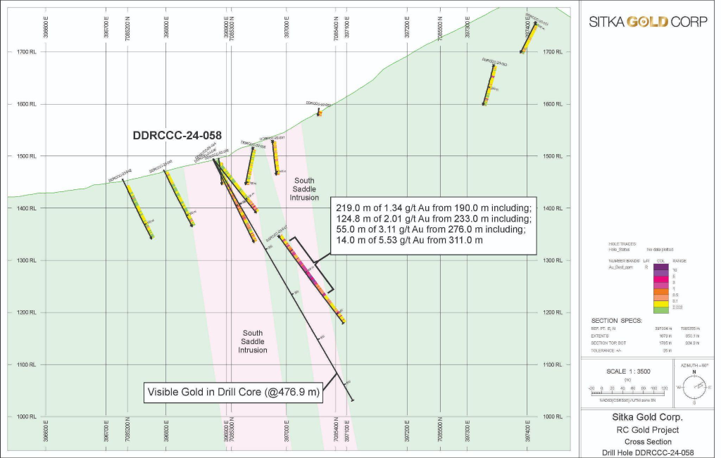
Sitka Gold (TSXV:SIG) has recently reported a significant finding in its 2024 winter diamond drilling program at the RC Gold Project in Yukon’s Tombstone Gold Belt. The company has drilled a total of 1085.1 meters this year, aiming for a total of 15,000 meters. The second drill hole of 2024, designated DDRCCC-24-58 or Hole 58, located 70 meters north of the prior hole DDRCCC-24-057, has shown visible gold within sheeted veining in megacrystic quartz monzonite intrusive rock. This hole reached a depth of 534.9 meters with specific geological orientations.
This drilling activity is part of a wider exploration program focusing on expanding and understanding the mineralization at the RC Gold Project. Notably, Hole 58 aimed to explore the extension of mineralization previously identified, confirming the continuity of high-grade mineral zones. The drill hole intersected two broad zones of quartz monzonite and feldspar porphyry within a geological formation known for hosting gold, with visible gold observed at significant depths.
Sitka Gold’s exploration goals for 2024 include further delineating the mineralization within the Clear Creek Intrusive Complex area, where the Blackjack and Eiger gold deposits are located. Both deposits are currently open in all directions, indicating potential for further expansion. The winter drilling phase has been completed, with plans to resume after a short break due to spring thaw conditions in Yukon.
Cor Coe, Director and CEO of Sitka Gold, commented in a press release: “Observations of visible gold within significant intervals of megacrystic quartz monzonite (intrusive rock) in the first two step out drill holes of our winter diamond drilling campaign at RC Gold are very encouraging and further support that robust gold mineralization remains persistent in this area, which is still open in all directions. These successful step outs show that mineralization encountered in Hole 47 continues in Hole 57 and 58 and demonstrates the significant potential to expand higher grade gold mineralization to the south and southeast of the current Blackjack deposit, which remains open in all directions, and we are eagerly awaiting the assay results. Our team has done a wonderful job getting an early start on the planned 15,000 metre diamond drilling program for this year. As the only company drilling in the Tombstone Gold Belt this winter, the advantages of having proximity to existing infrastructure, including year-round road access, are hard to ignore and bode well for current and future development of RC Gold. The Blackjack gold deposit is a strong example of the geological potential of the district-scale and still largely underexplored land package where over 1.3 million ounces of gold has been defined and nine outcropped intrusions associated with gold mineralization have been identified to date. With a gold resource that is poised for significant growth and several additional high priority intrusion-related gold targets across the 386 square kilometre property, Sitka is very well positioned to capitalize on a strengthening gold market as we continue with our fully funded 2024 diamond drilling program at RC Gold.”
The RC Gold Project represents a substantial land package within Yukon’s notable gold mining region. Located between two significant mining operations, the project boasts access and infrastructure conducive to mining activities. In early 2023, Sitka Gold announced an initial mineral resource estimate for the RC Gold Property, highlighting the potential of the Blackjack and Eiger deposits for open-pit mining and heap leaching, with promising gold recovery rates.
This development underscores the potential of the RC Gold Project in contributing to the understanding and exploitation of Yukon’s mineral wealth. Sitka Gold’s ongoing exploration efforts aim to further uncover the extent of mineralization, with the ultimate goal of developing a viable mining operation.
RC Gold Inferred Mineral Resource Estimate
| COG g/t Au | Blackjack Zone | Eiger Zone | Combined | ||||||
| Tonnes 000’s | Au g/t | 0z Au 000’s | Tonnes 000’s | Au g/t | 0z Au 000’s | Tonnes 000’s | Au g/t | 0z Au 000’s | |
| 0.20 | 35,798 | 0.80 | 921 | 32,523 | 0.45 | 471 | 68,321 | 0.63 | 1,391 |
| 0.25 | 33,743 | 0.83 | 900 | 27,362 | 0.50 | 440 | 61,105 | 0.68 | 1,340 |
| 0.30 | 31,282 | 0.88 | 885 | 22,253 | 0.55 | 393 | 53,535 | 0.74 | 1,279 |
| 0.35 | 29,065 | 0.92 | 860 | 17,817 | 0.60 | 344 | 46,882 | 0.80 | 1,203 |
| 0.40 | 26,975 | 0.96 | 833 | 14,506 | 0.66 | 308 | 41,481 | 0.86 | 1,140 |
Notes
1. Mineral resource estimate prepared by Ronald G. Simpson of GeoSim Services Inc. with an effective date of January 19, 2023. Mineral Resources are classified using the 2014 CIM Definition Standards.
2. The cut-off grade of 0.25 g/t Au is believed to provide a reasonable margin over operating and sustaining costs for open-pit mining and processing
3. Mineral resources are constrained by an optimised pit shell using the following assumptions: US$1800/oz Au price; a 45° pit slope; assumed metallurgical recovery of 85%; mining costs of US$2.00 per tonne; processing costs of US$8.00 per tonne; G&A of US$1.50/t.
4. Mineral resources are not mineral reserves and do not have demonstrated economic viability.
5. Totals may not sum due to rounding.
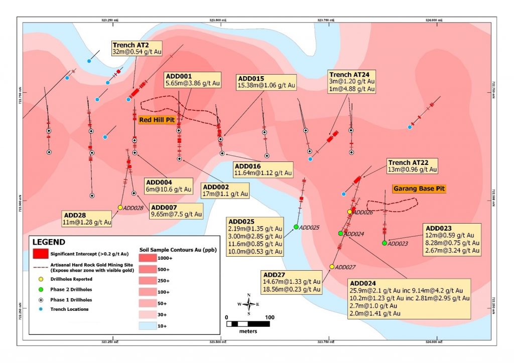
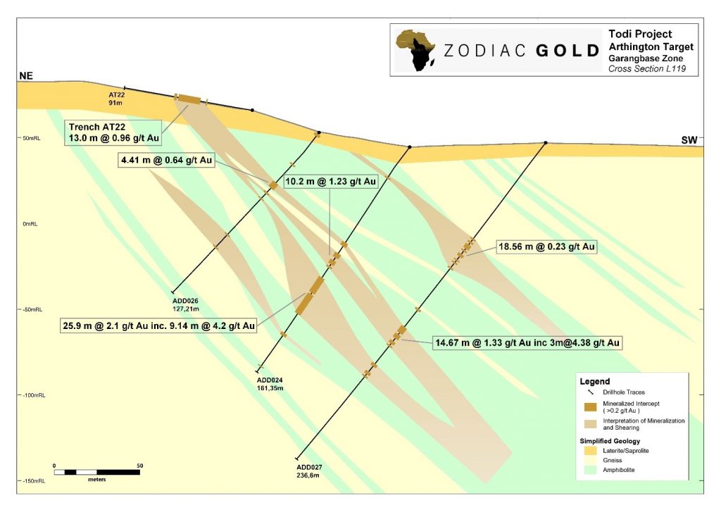
Zodiac Gold (TSXV:ZAU) has announced additional positive results from its ongoing Phase II Drill Program at the Arthington Target, located within their Todi gold project in Liberia, West Africa.
The Arthington Target is situated on an 18.5 km long mineralized trend and is one among five high-priority targets within the company’s expansive Todi project. In 2022, a Phase I program identified gold mineralization in 20 out of 22 drill holes.
David Kol, President & CEO of Zodiac Gold, commented in a press release: “The mineralization that we’ve found in all six of the Phase II drill holes that we’ve announced to date is very exciting. We are committed to continue to advance our exploration efforts further along strike to increase resource potential in the Arthington target. We are excited to see the future results over the coming weeks.
The Phase II program, currently underway, targets 2,000 meters of drilling focused on specific zones within Arthington. Earlier in 2024, the company reported positive results from the first three drill holes.
This latest update details findings from three additional holes (ADD026, ADD027, and ADD028). All three intercepted multiple zones of gold mineralization hosted within shear zones, confirming the extension of mineralization down-dip.
These drill holes revealed shear-hosted gold with intercepts cutting through several shallowly dipping mineralized zones. The mineralized zone spans over 1,000 meters along strike and reaches depths of 180 meters vertically, indicating a sizable gold footprint.
Particularly notable were mineralized structures identified in holes ADD027 (14.67 meters at 1.33 g/t Au) and ADD028 (11.00 meters at 1.28 g/t Au), suggesting strong potential for further mineralization.
The ongoing drilling program aims to extend the strike length of the Arthington Shear Zone to at least 2,400 meters, encompassing additional zones currently being drilled. The distinct mineralized intervals in all three recent holes reinforce the significant potential of the Arthington Target and the Todi Project as a whole.
Highlights from the results are as follows:
Table 1: Significant Intercepts at the Arthington Target
| Hole ID | From (m) | To (m) | Interval (m) | Average Au (g/t) |
| ADD026 | 1.10 | 2.82 | 1.72 | 0.39 |
| ADD026 | 38.80 | 43.21 | 4.41 | 0.64 |
| ADD026 | 46.36 | 47.60 | 1.24 | 1.05 |
| ADD026 | 51.15 | 52.00 | 0.85 | 1.91 |
| ADD026 | 90.00 | 91.00 | 1.00 | 0.94 |
| ADD027 | 70.44 | 89.00 | 18.56 | 0.23 |
| ADD027 | 122.80 | 124.10 | 1.30 | 1.26 |
| ADD027 | 136.33 | 151.00 | 14.67 | 1.33 |
| ADD027 | 164.00 | 166.00 | 2.00 | 0.64 |
| ADD027 | 170.00 | 174.00 | 4.00 | 0.70 |
| ADD028 | 116.00 | 118.00 | 2.00 | 0.46 |
| ADD028 | 125.00 | 128.00 | 3.00 | 0.35 |
| ADD028 | 195.00 | 206.00 | 11.00 | 1.28 |
| Significant intersections have been determined as intervals above 0.2 g/t Au and a maximum of 2m of consecutive samples below 0.2 g/t Au. Intervals are drilled rather than true thicknesses. | ||||
Table 2: Collar Information for the Reported Holes
| Hole ID | Easting (UTM WGS 84 29N) |
Northing (UTM WGS 84 29N) |
Elevation (m) |
Azimuth | Dip (degrees) |
Depth (m) |
| ADD026 | 323798 | 722473 | 53 | 20 | -52 | 127.21 |
| ADD027 | 323757 | 722346 | 47 | 20 | -52 | 236.60 |
| ADD028 | 323267 | 722483 | 59 | 15 | -60 | 227.75 |
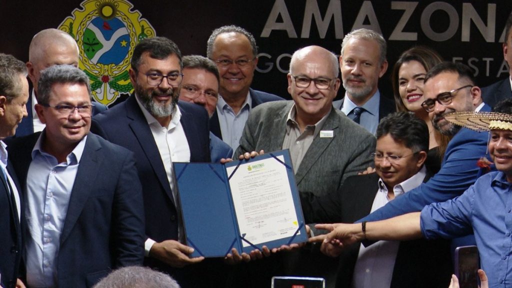
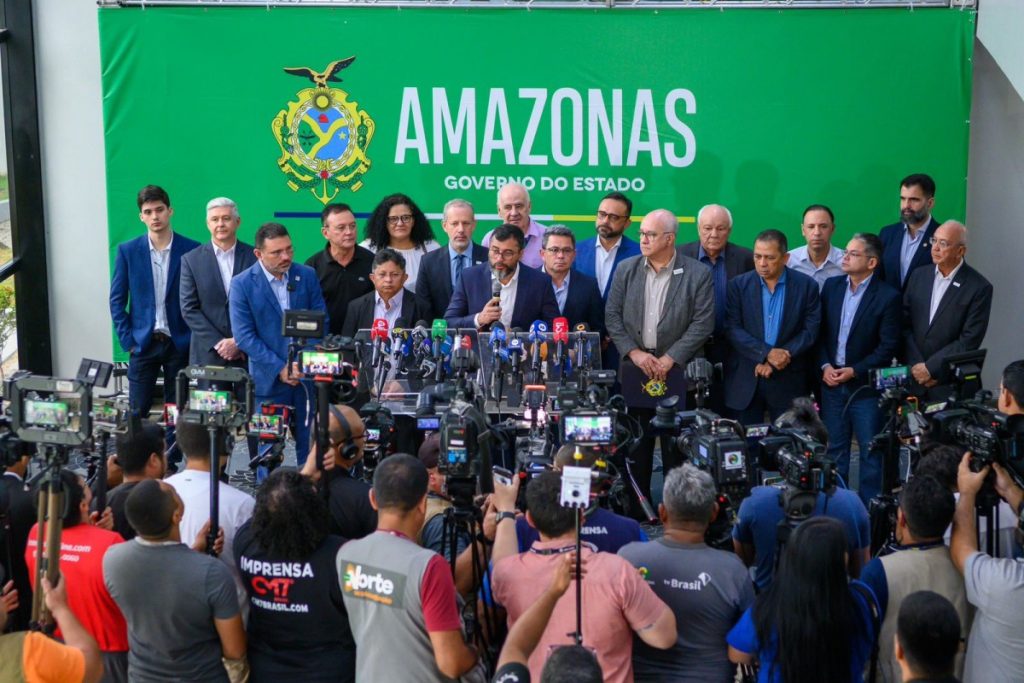
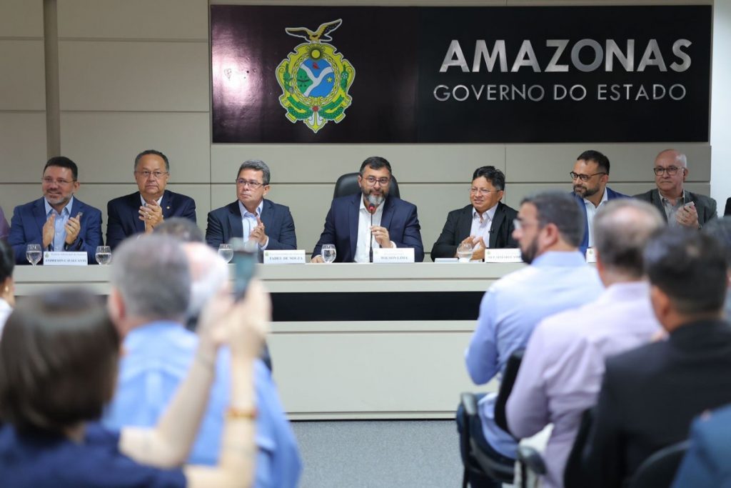
Governor Wilson Lima, on Monday, April 8, 2024, delivered the first environmental license for the Autazes Potash Project managed by Brazil Potash in the municipality of Autazes, located 113 kilometers from Manaus. This decision marks the end of a 15-year waiting period, initiating a project expected to majorly boost the local and national economy. During its installation phase, the project is anticipated to create 2,600 direct jobs. Once operational, it’s projected to generate over 17,000 direct and indirect jobs, making it an important contributor in Brazil’s job market.
Wilson Lima commented at an event at the State Government headquarters: “The implementation of an activity like this generates social indicators, quality of life for indigenous people, work opportunities, employment, income, advances in sanitation, water supply, asphalting of branches, education, health, in short, what It’s important so you can have a better place to live.”
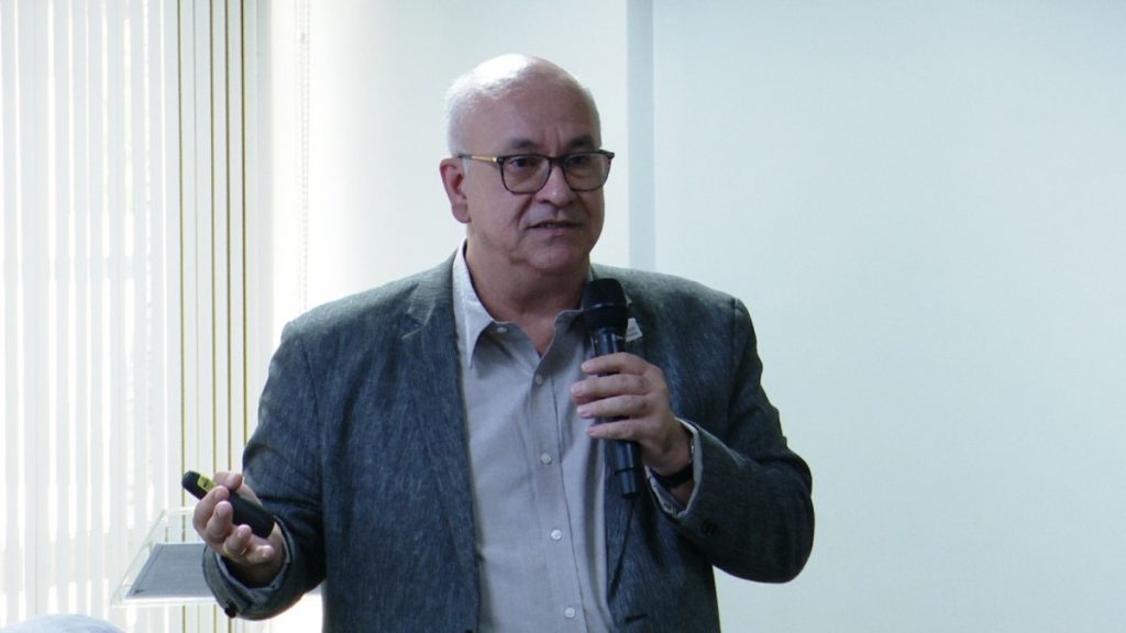
President of Potássio do Brasil, Adriano Espeschit, stated: “Today we can say that Amazonas has a sustainable mining project, starting with this event. With this installation license, we will ensure that it moves forward and that these numbers and results become reality as quickly as possible. Thank you very much to the entire State Government team.”
The project, focusing on the exploration of potassium, a critical raw material for fertilizer production, aims to fulfill 20% of Brazil’s national demand. This initiative could significantly reduce the country’s reliance on imported ore. Potassium from this project will not only support Brazilian agriculture but also contribute to global food security, as stated by Raul Jungmann, the director-president of the Brazilian Mining Institute (Ibram).
“Brazil’s agricultural sector feeds approximately 1 billion inhabitants on the face of the earth. This means that we will reduce our external dependence on this mineral, which is decisive for our production”, stated Jungmann, who sent Ibram’s Director of Relations, Alexandre Valadares, to represent him at the event.
Potássio do Brasil, the company behind this venture, plans to invest US$2.5 billion in the project, with R$1 billion already spent. The construction of the manufacturing plant alone, expected to take 4 and a half years, will provide 2,600 direct jobs. The operation phase will offer 1,300 direct jobs and an additional 16,000 indirect jobs, with an emphasis on employing local workers, aiming for up to 80% local labor use.
The environmental aspect has been a significant consideration. Granted by the National Mining Agency to Potássio Brasil in 2009, the project promises to be among the most environmentally friendly potash explorations globally. This includes low carbon emissions and minimal surface impact due to the high-tech, 800-meter-deep underground mining techniques.
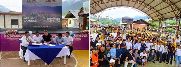
The event, attended by various government and local officials, emphasized the project’s benefits for the Mura people and the entire Amazonas population. The project has gained approval from local communities, including the indigenous Mura ethnic group, and is committed to environmental and social responsibilities. This includes infrastructure investments, social and environmental programs, and workforce training.
“Our people come from a lot of struggles and a lot of race. Now, we are here facing this historic moment. This venture comes to benefit us and has been expected for many years. We followed all the protocols, we complied with all the rules and from now on I only hope for much success for our indigenous people”, said the coordinator of the Mura Indigenous Council, Kleber Mura.
A 165 km long power transmission line and a 12-kilometer road reconstruction are part of the infrastructure development plans. Additionally, a large port for ore transportation and support for family farming with 2% of Potassium Chloride production are also planned. These efforts aim to provide extensive benefits to the Amazonas population, ranging from job creation and income generation to regional infrastructure development and environmental preservation.
“Ipaam’s role is to ensure that all licensing requirements are met as long as it authorizes the activity. It is a historic milestone for the State Government, because it enables an economic matrix that, I point out that after the Manaus Free Zone, is the second biggest ‘boom’ in the economy of Amazonas”, said the director-president of Ipaam, Juliano Valente.
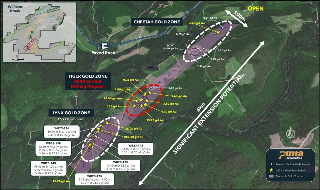
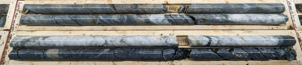
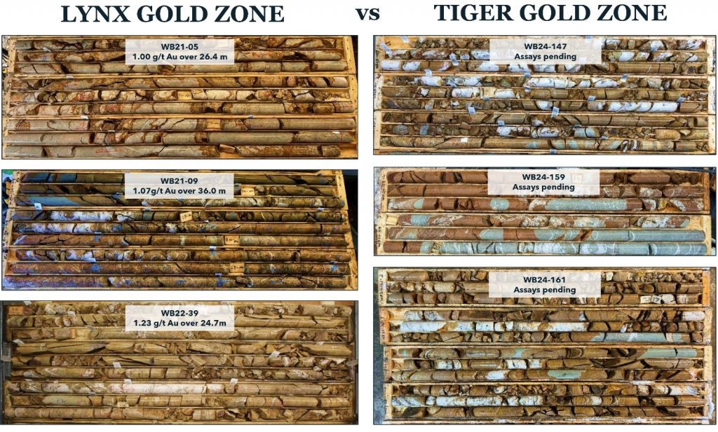
Puma Exploration (TSXV:PUMA) recently shared updates on its drilling activities at the Tiger Gold Zone (TGZ) within the Williams Brook Gold Project in Northern New Brunswick. The company owns 100% of this project and has initiated a 2,000 meters drilling program targeting the gold zone discovered last year. The aim is to explore the northeast extension of the gold mineralized corridor from the Lynx Gold Zone (LGZ) over a 1.5 km stretch and to potentially widen this zone. Initial observations from the drilling cores have been positive, leading to an expansion of the drilling program.
Marcel Robillard, President and CEO of Puma Exploration, commented in a press release: “We are thrilled with what we see in the first 800 metres drilled so far at Tiger. The core exhibits the same pervasive alteration and mineralization characteristic of the Lynx Gold Zone. This further supports our belief that we are dealing with a large gold system and that the Lynx Gold Zone extends at least 1.5 kilometres along strike. Following these observations, we have expanded our drilling program by adding scouting drill holes along another 2-kilometre extension. With our exploration program fully funded, our focus is to grow the scale and resource along the Lynx Gold Trend in 2024.”
The drilling at TGZ is designed in a shallow fan pattern to examine the mineralization beneath the surface gold veins, which were identified through trenching and mapping in the previous year. This effort seeks to understand the factors controlling gold mineralization in the area and how the TGZ integrates into the company’s existing structural and lithological models. It’s important to note, however, that grab samples, which are part of the exploration process, are selective and might not accurately reflect the overall metal content of the mineralized zones.
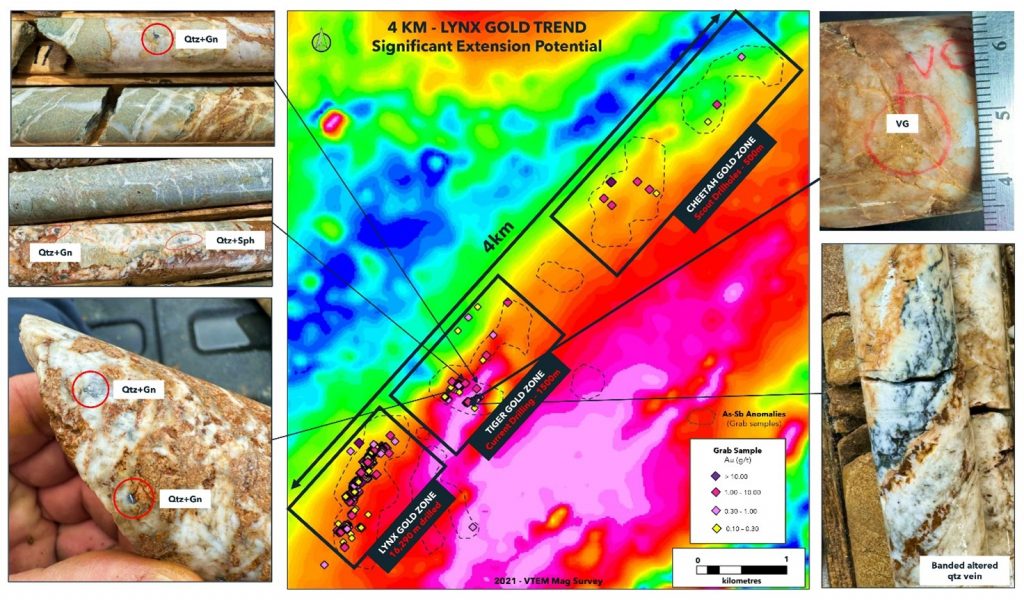
Previous geophysical and geochemical surveys have pointed out several target areas along the Lynx Gold Trend. Limited trenching conducted by earlier operators followed these surveys. Last year, Puma uncovered another promising gold area named the Cheetah Gold Zone (CHGZ), revealing 6.69 grams per tonne (g/t) gold from its initial trenching and sampling.
The TGZ, located 350 meters from the LGZ, was expanded through surface exploration work along the Lynx Gold Trend in 2023. This work confirmed gold mineralization over a stretch exceeding 1.5 km, with four significant mineralized quartz veins yielding high-grade gold results, including assays of 19.90 g/t and 14.50 g/t gold. These findings confirm the continuity of high-grade gold mineralization within the hydrothermal alteration corridor observable at the surface. The exploration program has also verified that the gold mineralized corridor extends to shallow depths at Tiger, remaining open along its strike and depth.
The area of the Tiger Gold Zone now covers 400 meters by 180 meters. Gold here is primarily found in quartz veins, which range from drusy to massive, and are accompanied by minor carbonate and sulphides like chalcopyrite, sphalerite, galena, and malachite. This mineralization pattern is similar to the high-grade veins previously discovered at the Lynx Gold Zone. Notably, these quartz veins are located at the juncture between different rock types, including volcanic and sedimentary units and a significant mafic unit, indicating a complex geological setting conducive to gold deposition.
Highlights from the results are as follows:
- Fifteen (15) holes with depths from 25 to 150 m have been completed for a total of 875 metres.
- The holes were drilled 425 metres from the Lynx Gold Zone (Figure 1).
- All holes intersected the targeted favourable gold-bearing horizon of quartz veins / stockwork in altered sediment and gabbro units.
- Visible gold was observed in hole WB24-151 in a quartz vein in altered gabbro (Figure 2).
- The same pervasive alteration corridor characteristic of the LGZ is observed at Tiger (Figure 3).
The above references an opinion and is for information purposes only. It is not intended to be investment advice. Seek a licensed professional for investment advice. The author is not an insider or shareholder of any of the companies mentioned above.
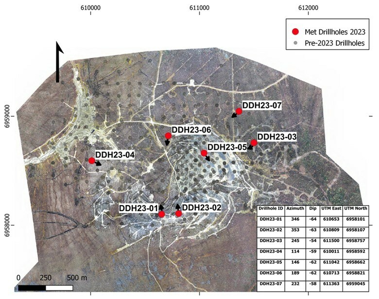
Western Copper and Gold (TSX:WRN) has announced the commencement of a metallurgical testing program for its wholly-owned Casino Copper-Gold Project. The program, which was prepared by Western’s Technical and Sustainability Committee, consisting of members from Western, Rio Tinto Canada Inc., and Mitsubishi Materials Corporation, will utilize fifteen composite samples obtained from core acquired during the company’s 2023 drill program.
The 2023 drill program, which was also designed by the Technical and Sustainability Committee, consisted of seven holes totaling 2,244 meters in length, with individual holes ranging from 130 meters to 556 meters. The drill holes were strategically located within the current pit boundaries to provide a diverse range of grades, host rocks, and mineralogy for the metallurgical testing program. Additionally, the drill holes were selected with the goal of converting indicated resources to measured status.
The drill results continue to highlight the significance of the Core Zone, where relatively higher grades are encountered. This is exemplified by DDH23-05, which intersected 158.5 meters of supergene mineralization, partially oxidized, with a copper equivalent grade of 0.82%. Furthermore, DDH23-04, located approximately one kilometer west of the Core Zone, and DDH23-06, situated at the northwest edge of the Core Zone, intercepted 86.0 meters of 0.56% copper equivalent and 174.0 meters of 0.52% copper equivalent, respectively, in the supergene zone.
The fifteen composite samples, representing both supergene and hypogene mineralization at various grades, will undergo comminution and flotation tests to produce a definitive concentrate from each composite. The results from this testing will be instrumental in developing a more comprehensive geometallurgical model of the deposit. The test program is being conducted at ALS Metallurgy in Kamloops, British Columbia, under the supervision of personnel from Western, Rio Tinto Canada Inc., and Mitsubishi Materials Corporation.
The launch of the metallurgical testing program marks a significant step forward for Western Copper and Gold Corporation in advancing the Casino Copper-Gold Project. The program’s findings will provide valuable insights into the project’s potential and contribute to the ongoing development and optimization of the mining operation. The collaboration between Western, Rio Tinto Canada Inc., and Mitsubishi Materials Corporation in overseeing the drill and metallurgical programs demonstrates the strong partnership and shared commitment to the success of the Casino project.
As the metallurgical testing program progresses, Western Copper and Gold Corporation is expected to provide further updates on the results and their implications for the Casino Copper-Gold Project. The company remains focused on advancing the project while prioritizing sustainability and working closely with its partners to maximize the value of this significant copper-gold resource.
Highlights from the program are as follows:
Table 1: 2023 drill program results
|
Zone3 |
From |
To |
Length |
Cu (%) |
Au (g/t) |
Mo (%) |
Ag (g/t) |
CuEq1 |
|
DDH23-01 |
||||||||
|
CAP |
0.0 |
100.2 |
100.2 |
0.02 |
0.28 |
0.011 |
2.3 |
0.28 |
|
Supergene |
100.2 |
244.2 |
144.0 |
0.19 |
0.31 |
0.008 |
2.3 |
0.46 |
|
SUS |
100.2 |
244.2 |
144.0 |
0.19 |
0.31 |
0.008 |
2.3 |
0.46 |
|
HYP |
244.2 |
400.0 |
155.8 |
0.08 |
0.13 |
0.002 |
1.0 |
0.19 |
|
DDH23-02 |
||||||||
|
CAP |
3.2 |
72.2 |
69.0 |
0.02 |
0.25 |
0.006 |
1.4 |
0.22 |
|
Supergene |
72.2 |
229.0 |
156.8 |
0.21 |
0.32 |
0.013 |
1.9 |
0.50 |
|
SOX |
72.2 |
92.5 |
20.3 |
0.11 |
0.25 |
0.006 |
1.5 |
0.31 |
|
SUS |
92.5 |
229.0 |
136.5 |
0.22 |
0.33 |
0.014 |
1.9 |
0.52 |
|
HYP |
229.0 |
556.0 |
327.0 |
0.17 |
0.21 |
0.016 |
1.2 |
0.38 |
|
DDH23-03 |
||||||||
|
CAP |
22.1 |
25.1 |
3.0 |
0.06 |
0.10 |
0.002 |
0.7 |
0.14 |
|
Supergene |
25.1 |
109.5 |
84.5 |
0.24 |
0.22 |
0.006 |
1.5 |
0.43 |
|
SOX |
25.1 |
42.6 |
17.5 |
0.19 |
0.19 |
0.003 |
1.3 |
0.34 |
|
SUS |
42.6 |
109.5 |
66.9 |
0.26 |
0.23 |
0.006 |
1.6 |
0.45 |
|
HYP |
109.5 |
528.0 |
418.5 |
0.18 |
0.23 |
0.018 |
2.4 |
0.43 |
|
DDH23-04 |
||||||||
|
CAP |
4.7 |
56.6 |
51.9 |
0.04 |
0.15 |
0.021 |
1.9 |
0.25 |
|
Supergene |
56.6 |
142.6 |
86.0 |
0.30 |
0.20 |
0.027 |
2.4 |
0.56 |
|
SUS |
56.6 |
142.6 |
86.0 |
0.30 |
0.20 |
0.027 |
2.4 |
0.56 |
|
DDH23-05 |
||||||||
|
CAP |
5.6 |
72.0 |
66.4 |
0.03 |
0.21 |
0.031 |
1.0 |
0.31 |
|
Supergene |
72.0 |
230.5 |
158.5 |
0.37 |
0.41 |
0.039 |
1.6 |
0.82 |
|
SOX |
72.0 |
159.0 |
87.0 |
0.39 |
0.39 |
0.043 |
1.5 |
0.84 |
|
SUS |
159.0 |
230.5 |
71.5 |
0.35 |
0.44 |
0.032 |
1.9 |
0.79 |
|
DDH23-06 |
||||||||
|
CAP |
8.5 |
20.5 |
12.0 |
0.07 |
0.40 |
0.010 |
2.2 |
0.41 |
|
Supergene |
20.5 |
194.5 |
174.0 |
0.21 |
0.36 |
0.013 |
1.6 |
0.52 |
|
SOX |
20.5 |
86.5 |
66.0 |
0.25 |
0.53 |
0.013 |
2.0 |
0.69 |
|
SUS |
86.5 |
194.5 |
108.0 |
0.18 |
0.25 |
0.012 |
1.4 |
0.41 |
|
HYP |
194.5 |
256.8 |
62.3 |
0.06 |
0.07 |
0.011 |
0.6 |
0.16 |
|
DDH23-07 |
||||||||
|
CAP |
– |
– |
– |
– |
– |
– |
– |
|
|
Supergene |
34.2 |
77.1 |
42.9 |
0.22 |
0.18 |
0.006 |
1.3 |
0.39 |
|
SUS |
34.2 |
77.1 |
42.9 |
0.22 |
0.18 |
0.006 |
1.3 |
0.39 |
|
HYP |
77.1 |
130.3 |
53.2 |
0.24 |
0.25 |
0.014 |
1.8 |
0.48 |
|
1CuEq metal prices: $US 3.60/lb Cu, $US 1700/oz Au, $US 14/lb Mo, $US 22/lb Ag with no adjustment for metallurgical recovery. |
|
2Widths are core length, not true width of mineralized intersection |
|
3CAP – leached cap, SUS – supergene sulphide, SOX – supergene oxide, HYP – hypogene |
The above references an opinion and is for information purposes only. It is not intended to be investment advice. Seek a licensed professional for investment advice. The author is not an insider or shareholder of any of the companies mentioned above.
If you would like to receive our free newsletter via email, simply enter your email address below & click subscribe.
 Follow us on Twitter
 Become our facebook fan
CONNECT WITH US
Tweets
Tweet with hash tag #miningfeeds or @miningfeeds and your tweets will be displayed across this site.
MOST ACTIVE MINING STOCKS
Daily Gainers
 CMC Metals Ltd. CMC Metals Ltd. |
CMB.V | +900.00% |
 Eden Energy Ltd Eden Energy Ltd |
EDE.AX | +200.00% |
| GoviEx Uranium Inc. |
GXU.V | +42.86% |
| Eagle Nickel Ltd. |
ENL.AX | +41.67% |
| Citigold Corp. Limited |
CTO.AX | +33.33% |
| Mount Burgess Mining NL |
MTB.AX | +33.33% |
| Exalt Resources Limited |
ERD.AX | +31.94% |
| Casa Minerals Inc. |
CASA.V | +30.00% |
| Cariboo Rose Resources Ltd |
CRB.V | +28.57% |
| Belmont Resources Inc. |
BEA.V | +28.57% |