Carolina Rush (TSXV:RUSH) has recommenced drilling operations at its Brewer Gold-Copper Project in South Carolina. This move follows the completion and analysis of the first seven holes from the Phase IV drilling program. The renewed drilling efforts aim to further explore and delineate the mineralized zones within the property, with a particular focus on the recently identified Tanyard Breccia Zone.
Focus on the Tanyard Breccia Zone
The current phase of drilling concentrates on the Tanyard Breccia Zone, a new discovery located to the south of the historic Brewer Mine. This zone was highlighted in a news release by the company on February 28, 2024. Initial assay results from the area have confirmed the presence of a mineralized breccia body, characterized by significant gold-copper mineralization. This mineralization is hosted within a zone of intense quartz-pyrophyllite alteration, a geological environment typically associated with precious metal deposits.
Higher grade gold concentrations have been identified within discrete zones of highly silicified, pyritic breccia. The company has planned an additional four drill holes in the Tanyard area to target concealed mineralization beneath the maar sedimentary sequence. These new holes will also seek to extend the high-grade gold-telluride mineralization encountered in a previous drill hole (hole 21), which reported a significant intersection of 2.5 meters at 169 grams per ton (g/t) of gold.
Extension of Historic Drill Hole B21C-016
In addition to the new drill holes in the Tanyard Breccia Zone, Carolina Rush has announced plans to deepen a previously drilled hole (B21C-016) located in the northwest part of the property. This hole, which was initially drilled to a depth of 380 meters, is situated approximately 500 meters northwest of the historic Brewer pit.
The decision to deepen this hole stems from the discovery of strong quartz-pyrophyllite alteration with gusano textures near the bottom of the initial drill. These features, coupled with elevated molybdenum levels, suggest the potential presence of a primary porphyry copper system. To explore this possibility, the company will extend the hole by an additional 200 meters, bringing its total depth to nearly 600 meters. The results from this extended drilling are anticipated to provide further insights into the property’s mineral potential.
Recent Drill Results
The company has also released new results from two recent drill holes, B24C-031 and B24C-032. These holes confirmed the presence of the Tanyard Breccia, although they reported low gold values from the periphery of the structure. Despite the lower gold content, the confirmation of the breccia body’s presence is seen as a positive indicator for the ongoing exploration efforts.
Samples, typically 1.5 meters in length, were sawn in half, with one-half sent for analysis and the other half retained for future reference. The samples were sent to ALS Laboratory in Twin Falls, Idaho, where they underwent drying, crushing, and pulverization before being analyzed for gold content using fire assay methods with atomic absorption (AA) finish. For samples containing greater than 10.0 g/t gold, a gravimetric finish was applied. Multielement analyses were conducted using ICP-MS following a four-acid digestion, with specific methods employed for samples containing over 1.0% copper.
The resumption of drilling at the Brewer Gold-Copper Project marks a significant step in Carolina Rush’s ongoing exploration efforts in South Carolina. With a focus on the newly discovered Tanyard Breccia Zone and the potential extension of mineralization in other parts of the property, the company is poised to further understand the mineral potential of this historically significant mining area. As the drilling progresses, Carolina Rush anticipates gaining deeper insights that could shape the future development of the Brewer project.
The above references an opinion and is for information purposes only. It is not intended to be investment advice. Seek a licensed professional for investment advice. The author is not an insider or shareholder of any of the companies mentioned above.

MiningFeeds recently had the opportunity to sit down with George Bee, the CEO of U.S. Gold Corp. (NASDAQ:USAU), for an in-depth discussion about his career, the strategic direction of U.S. Gold Corp., and the exciting prospects of the CK Gold Project in Wyoming. George Bee, with his extensive background in the mining industry, offers a wealth of knowledge and experience that has helped guide U.S. Gold Corp. through critical stages of development. The following is an unfiltered view of our conversation, capturing George’s insights as he delves into the past, present, and future of U.S. Gold Corp. and the mining industry.
From Retirement to U.S. Gold Corp: A New Chapter
After a long and successful career with Barrick, where he played an important role in the development of the Goldstrike mine in Nevada, and contributing to some of the most prolific gold trends in mining history, George Bee decided to come out of retirement. When asked what compelled him to take on a new challenge with U.S. Gold Corp., he replied:
“There’s only so much skiing and outdoor activities you can do before thinking, ‘I should use my accumulated experience!’ I sat on a number of boards and was involved in some consulting when I met Luke Norman, our Executive Chairman and co-founder of the company. We were looking at something totally unrelated to US Gold and he then asked me to look at what was then called Copper King. The project looked dead simple, in a great jurisdiction and had good economic potential. I said, ‘that’s easy to develop and can be done on a fast-track basis.’ So, the moral of the story is to be careful what you say, you might get handed the keys, which is what happened.”
The CK Gold Project’s Economic Viability and Resource Expansion
The CK Gold Project has drawn considerable interest for its gold and copper production profile in a mining friendly state. However, beyond that is the potential for resource expansion and how by-product waste rock might factor into the project’s economics. In putting it all together, Bee emphasized the practical methodology U.S. Gold Corp. has taken in demonstrating the project’s viability:
“There was some skepticism about the project since it has a modest grade and sits alongside the Curt Gowdy State Park in southeast Wyoming. Before expanding the potential of the deposit, we had to first show that there was a compelling economic incentive to develop the project, and secondly demonstrate that we could get the project permitted. In December 2021 we published our prefeasibility study which showed, on the basis of the copper and gold in the deposit, robust economics evaluated at $1,625/oz gold and $3.25/lb copper. By September 2022 we had completed 2-years of environmental baseline studies and prepared a Mine Operating Permit (MOP) application and submitted it to the Wyoming Department of Environmental Quality – Land Quality Division (DEQ-LQD). In May 2024 we received conditional approval to proceed with the project, having already received another key permit approval, the Industrial Siting Permit, in June of 2023.”
Bee further elaborated on the future potential of the project, hinting at additional resources yet to be explored:
“We know that we have additional resources at depth and the orebody bottoms out in mineralization. There is also a trend to the southeast of the project that warrants additional exploration. The strategy has been to conserve treasury at a time when funds have been difficult to come by without excessive dilution and focus on what we have already defined. There is upside in the resource and we will pursue that in due course.”
“Not All Ounces Are Created Equal”: Insights from the SME Conference
During the recent SME (Society for Mining, Metallurgy & Exploration) conference in New York, George Bee delivered a keynote speech on the notion that “not all ounces are created equal.” He used his extensive experience in various mining projects worldwide to illustrate this point:
“Having worked on remote projects high up in the Andes in South America, the point I was making is that if a project is not close to infrastructure, has no power supply nearby, needs to transport, house and feed personnel, hold large inventories of critical spares to maintain the operation, then there better be higher grade reserves with higher economic margin to support the development. I was able to show the juxtaposition between some of the projects that I have been involved with and the CK Gold Project to demonstrate that the location is vastly superior to other similar projects. We are in a stable jurisdiction with no political risk, we know the rules of the game through established statutes governing the activity, the infrastructure is second to none, people can work and go home after their shift, and we are well supported locally by contractors who are well equipped to serve our needs. The point is that an ounce of gold on top of a mountain in the Andes is not the same as an ounce 20-miles outside of Cheyenne, Wyoming in terms of its economic potential. There are also the technical factors associated with the metallurgical recovery of that ounce but I believe you see my point.”
The Strategic Importance of Rail Proximity
The CK Gold Project stands out for its gold and copper potential and for the strategic opportunities presented by its waste rock. The proximity to rail infrastructure could play a crucial role in maximizing the economic benefits of this by-product, as Bee explains:
“Our current plan and permit are centered around the recovery of gold and copper into a copper gold concentrate, producing around 160 tons per day. This can be trucked away without much impact to the local road infrastructure. In looking at on-site material to support the construction of the project, we found that the ‘waste’ rock that we will have to move and set aside to get at the copper and gold ore is a superior aggregate resource. Our current plans show that we set the waste aside and reclaim and revegetate that waste in piles created adjacent to the open pit. Once we have accounted for the rock that we need to build roads, stabilize tailings and other on-site needs, it’s estimated there will be more than 35 million tons in the piles to be reclaimed. Our neighbors, in a quarry 3-miles to our south, mine rock with no gold or copper in it and sell it at the gate for around $20/ton. What we want to explore is putting the rock we have set aside to beneficial use. It would be a win-win scenario since the State will receive a royalty payment, the mine can sell the rock which we have already paid to mine, we reduce our reclamation footprint and area of impact, and the fuel and energy expended to remove the rock would offset the energy needed to produce the rock someplace else if we put the rock to good use.”
Bee continued to highlight the significance of rail proximity for the project’s long-term success:
“The issue is that it is a bulk commodity. While we could move a fair amount by road with the necessary impacts mitigated, it would be much better to move the rock to market by rail. This lowers impacts, extends the commercial area that could be served, and increases the amount that could be sold. Our focus is getting the copper and gold mine up and running. Commercializing the waste rock is an opportunity and the proximity of rail to the site provides a great deal of potential. This is a matter for further planning, discussion with the locals and a permitting exercise.”
Wyoming’s Resource Tradition
Wyoming’s longstanding tradition as a resource state has also influenced the CK Gold Project’s development. Bee compared Wyoming to other jurisdictions he has worked in, highlighting the unique advantages the state offers:
“Wyoming has a population of almost 600,000 people and relies in large part on the revenues generated from the resource sector. Coal, oil, gas, trona, uranium resources are all recovered to help the economy and keep taxes low in the State. Coal mining has been a stalwart activity, but it is coming under pressure as coal-fired power generating stations age and are not replaced as society contends with concerns over emissions. Being well versed in regulating and managing the resource sector, Wyoming is an excellent jurisdiction with regulators, politicians, and people who realize the need for and benefits of the resource sector. The laws and statutes are well understood so an investor knows the ‘rules of the game’ and the regulators are knowledgeable, experienced, and motivated to support the resource sector. The CK Gold Project will be the first ‘hard rock’ mine permitted and brought into production in many years and offers a diversification in the resource sector in Wyoming at a time when coal production is diminishing. This allows US Gold Corp. to benefit from an established support sector for the mining with contractors, labor, and services looking for new opportunities.”
Reflecting on his experience in different parts of the world, Bee noted:
“I have worked in many different jurisdictions with differing levels of political stability, regulatory framework, and experience with the resource sector. I can attest to the fact that Wyoming is ready, willing, and able to support environmentally sound, responsible mining. This is not the case elsewhere and it’s quite frustrating especially in North America with its large land mass, well endowed with mineral wealth. The federal government, provinces and states tout their resource opportunities but often make it so difficult to actually bring those resources into production.”
Local Economic Benefits and Unique Project Attributes
The CK Gold Project is not just another mining operation; it will provide substantial benefits to the local economy and resource profile, receiving strong support from the community. Bee highlighted several factors that make this project unique and advantageous for the region:
“Again, Wyoming is a resource state, and the areas in which we are located are familiar with mining activity. There is a large active quarry (Granite Canyon Quarry) some 3-miles to our south, so people are aware of the activity. Located in southeast Wyoming, there is a greater tolerance of the resource sector. This would be totally different if the project was close to Yellowstone National Park or Jackson Hole. Being situated close to both the Interstate I-25 and I-80 means that the project is well served and an easy drive from Gillette, WY, Denver CO, and Salt Lake City UT, all centers where contractor and equipment support for the mining sector can be readily found. Not having to build a man-camp and long-distance transport, with a locally well-trained workforce that can live in the area around Cheyenne, are all huge factors in our favor as we compete for labor and talent.”
Bee also discussed the significant financial contributions the project is expected to make to the state, further solidifying its local support:
“Additionally, being on State land and operating under a lease with the State, several tens of millions of dollars will be paid in royalties, earmarked for K through Grade12 education, in addition to more than $88 million in taxes. We truly believe that the project will be a huge win for the local area providing good jobs and significant revenues.”
Looking to the future, Bee emphasized the positive legacy that the CK Gold Project could leave for the community:
“Furthermore, with an eye to the future and the positive legacy that we hope to leave when the mining is concluded, we believe that we can provide additional water storage for the city of Cheyenne obviating the need to increase the existing reservoir capacity in the Granite and Crystal Lakes in Curt Gowdy State Park. Eventually, Cheyenne needs more water storage to meet the growing needs of the city as it thrives. Water brought over from the Snowy Range west of Laramie is stored in the reservoirs in Curt Gowdy Park. Using the exhausted pit would avoid the need for a huge civil project to increase the reservoir capacity and the disruptions to the recreation facilities around the park. The reclaimed mine site could even be an extension to the park.”
Looking Ahead, Near Term Catalysts
As U.S. Gold Corp. continues to advance the CK Gold Project, updates to the prefeasibility study (PFS) have become a critical focus, especially in light of recent market changes. George Bee shared his expectations for where the updated PFS will reveal improvements:
“We obviously see that the initial gold and copper prices used at $1,625/oz and $3.25/lb, respectively, will be far outstripped by current prices. Conservatively, our evaluations at $2,000/oz gold and $4.00/lb copper, when the current prices are well in excess of those numbers, suggest significantly more revenue from production. This will be offset to some extent by increased costs due to inflation and higher capital costs since 2021. We believe that the margin will be preserved if not improved. Additionally, we continue to work on improvements and enhancements to the plan, and this is besides the aggregate opportunity.”
Looking forward to 2024, Bee identified several near-term catalysts that will drive the CK Gold Project closer to development:
“Now that we have established the criteria and commitments associated with our permit approval, we can finalize the facility designs and incorporate those into our PFS. We are also looking at a trade-off on some alternative flotation technology which purports better recovery from less equipment than our conventional flot cells in our current estimate. An updated PFS will show the direction we are taking and identify the opportunities that we hope to capitalize on for our feasibility study. Additionally, we hope to reveal partnership and/or financing avenues which demonstrate a pathway to completing development without excessive dilution to our shareholders.”
The Keystone Gold Project – Nevada
While the CK Gold Project remains the primary focus, U.S. Gold Corp. has not forgotten about the Keystone gold project, located just 11 miles south of Barrick-Newmont’s second largest gold operation in Cortez Hills. George Bee discussed the potential of Keystone and how the company plans to tap into it:
“The CK Gold Project has been our intense focus for the last few years, consuming our attention and treasury. We have done some low-cost remote work covering our 20-sq. mile Keystone property. The satellite imagery showed some anomalies in areas beyond our current primary targets. A field inspection and some grab samples revealed additional areas of mineralization and, as yet, additional exploration opportunities. We are very excited about the prospects for Keystone which we believe to have similarities and analogies to the multi-million-ounce Nevada Gold Cortex Complex. The reality though is that the appetite for exploration funding simply has not been there until recently, hence our pivot to the CK Gold Project. Keystone’s time will come and it is potentially a ‘game changer’ but needs several tens of millions of exploration dollars to do it justice. We will be pursuing Keystone in due course.”
In a candid assessment of U.S. Gold Corp’s current market valuation, Bee expressed his belief that the company is significantly undervalued given its assets and progress:
“Well you may have heard this from a number of entities but we truly believe, ‘we are significantly undervalued’ in the market. The current market does not seem to be a ‘normal’ market and the whole sector, not just US Gold Corp. is suffering. Typically proven and probable ounces in the ground should trade around $250 per ounce, implying a value of $360 million, just for the CK Project. The fact that we have a permit to develop the project and have essentially taken away that huge element of risk, should have us trading at around 50% of our NPV. At $325 million identified in our 2021 PFS, that should put USAU north of $150 million market capitalization on CK alone.”
Despite the current market challenges, Bee remains optimistic about the company’s future:
“And yet we are sitting around the $60 million mark, which speaks to a strange dynamic in the market. This being the case, we continue to ‘move the ball down the field’ towards development and the generation of free cash flow to form a stable, low risk project in a great jurisdiction. ‘Build it and they will come’ is the adage that comes to mind. Additionally, we continue to pursue avenues to realize value for our exceptional exploration assets. Stay tuned!”
Our discussion gave a more comprehensive look at U.S. Gold Corp’s strategic direction, the exciting potential of the CK Gold Project, and the challenges and opportunities facing the company. George Bee’s extensive experience and insights provide a clear understanding of why U.S. Gold Corp. is set for success, even in the face of recent short-term market volatility. As the company moves forward with its projects, the mining industry will be keeping a close eye on its progress, eagerly awaiting the next chapter in U.S. Gold Corp’s journey.
The above references an opinion and is for information purposes only. It is not intended to be investment advice. Seek a licensed professional for investment advice. The author is not an insider or shareholder of any of the companies mentioned above.

Westhaven Gold (TSXV:WHN) has provided an update on its ongoing activities at the Shovelnose gold property, located 30 kilometers south of Merritt, British Columbia. The Shovelnose property, which spans 41,623 hectares within the Spences Bridge Gold Belt (SBGB), is currently the focus of an extensive exploration campaign.
Gareth Thomas, President & CEO, commented in a press release: “Our “boots on ground” exploration approach this summer has identified what we feel could be the southeastern extent of Vein Zone One some 6 kilometres away from the South Zone. The discovery of banded mercury-bearing high level epithermal quartz makes us believe we are at the top of a completely preserved epithermal system at Certes. We look forward to drilling Certes and other high-priority targets in the coming weeks.”
The summer and fall phases of the 2024 drill campaign have commenced, targeting seven new high-priority areas within the property. Westhaven plans to conduct 4,000 meters of diamond drilling to test targets at several key sites, including Line 6 North, Line 6-MIK, CSAMT-3, Romeo, and three different locations along the Certes Trend. Each of these targets has been identified through a combination of prospecting, mapping, sampling programs, and a comprehensive review of geological, geochemical, and geophysical data gathered over the past two years.
The primary area of interest is the Shovelnose Corridor, a significant trend of multielement pathfinder anomalies that stretches over 11 kilometers across the property. This corridor extends into newly acquired claims to the southeast, where initial studies indicate less erosion has occurred. This suggests that a larger portion of the epithermal system may be preserved, potentially leading to further discoveries in the area.
Detailed Exploration Targets
The exploration efforts at Shovelnose are focused on specific targets, each chosen based on previous data and promising geological features.
– Line 6 North: This target will explore potential contacts of a rhyolite dome and related structural elements, which could be the source of broad, lower-grade gold mineralization found in earlier drilling.
– Line 6/Mik: Drilling will investigate a 500-meter-long gold-in-soil anomaly, located southwest of the Franz-FMN-South Zone mineralization. This area is believed to be influenced by geophysically inferred structures.
– CSAMT-3: Follow-up drilling will take place here after hole SN24-412 revealed molybdenum-rich silica-healed breccias and multiple zones of quartz-calcite veinlets, suggesting the presence of high-grade gold-silver mineralization nearby.
– Romeo: This site will test a pathfinder element halo identified through geochemical sampling, situated within a mapped zone of hydrothermal brecciation supported by intersecting structures found in geophysical data.
– Certes Trend: This 3-kilometer-long concentration of pathfinder elements will be explored in three areas spaced approximately 1 kilometer apart. The northwest end, central part, and southeastern extent of the Certes Trend will each be targeted for drilling, focusing on identifying and evaluating potential controlling structures.
Spring Drill Results and Ongoing Exploration
Westhaven is also reporting the results of 10 drill holes from the spring phase of the 2024 campaign, completed between March and June. These results, along with ongoing exploration data, have informed the current summer and fall drilling efforts. The location and access to the Shovelnose property allow for year-round drilling, enabling Westhaven to maintain continuous exploration activity.
The above references an opinion and is for information purposes only. It is not intended to be investment advice. Seek a licensed professional for investment advice. The author is not an insider or shareholder of any of the companies mentioned above.

Radius Gold (TSXV:RDU) has announced the initial results of its ongoing exploration program at the Plata Verde silver project in Chihuahua, Mexico. The company is working in partnership with Minera San Julian, S.A. de C.V., a subsidiary of Fresnillo plc, one of the world’s largest producers of silver. The project is focused on identifying bulk minable, underground silver resources in the historic Plata Verde mines.
Bruce Smith, CEO/President of Radius Gold commented in a press release: “We are excited to continue drilling at Plata Verde, particularly with the results from PV-09. The decision to extend the drill program reflects our commitment to fully explore and unlock the potential of this project.”
The first batch of assay results from the drill program at Plata Verde has been received, providing critical data on the potential of the site. The initial drilling phase included four holes, labeled PV-01 to PV-04, totaling approximately 900 meters. These were drilled on the eastern side of the valley, where multiple zones of low-grade silver mineralization were encountered. However, these results suggested limited potential for an economically viable discovery in this area of the eastern silver mantos.
The exploration team also drilled several holes on the western side of the valley, where the results have been more promising. Drill holes PV-05 through PV-08 revealed a greater thickness of the basaltic host rock, coupled with improved visual signs of mineralization. These developments have generated optimism among the exploration team, although the assay results for these holes are still pending.
The most recent hole, PV-09, was drilled further northwest and intersected a wider section of the basaltic host rock. This hole revealed the most visually attractive mineralization seen in the drilling program to date. Given these encouraging findings, Radius Gold and its joint venture partner, Minera San Julian, have decided to extend the drilling program. Three additional drill holes will be added to test the further extension of the promising target zone in the western area of the valley.
Radius Gold Inc. has a portfolio of exploration projects in Mexico and Guatemala, managed through strategic partnerships that allow the company to conserve its treasury. The company is actively seeking new investment and project acquisition opportunities globally. Radius is a member of the Gold Group of companies, led by Simon Ridgway. More information on Radius Gold can be found on their website or through SEDAR Plus.
The ongoing exploration at Plata Verde represents a key part of Radius Gold’s strategy to discover and develop significant silver resources in partnership with industry leaders like Fresnillo. As the drill program progresses, the company anticipates further updates on assay results and the potential for a major silver discovery at this historic site.
The above references an opinion and is for information purposes only. It is not intended to be investment advice. Seek a licensed professional for investment advice. The author is not an insider or shareholder of any of the companies mentioned above.

New Destiny Mining (TSXV:NED) has provided an update on its 2024 exploration program at the Treasure Mountain project, located near Princeton, British Columbia. The company has completed six drill holes so far, totaling 1,060 meters, within the Railroad area of the property, which is known for copper-silver mineralization.
The most recent drilling, designated as Hole 6 (TMN24-06), targeted a significant magnetic anomaly identified in regional survey data. This anomaly, centered just north of the Railroad zone, measures approximately one kilometer in diameter and is believed to be caused by an intrusion at depth. The drilling aimed to investigate the potential for a mineralized porphyry intrusive that could serve as the source for the copper mineralization observed in the Railroad zone.
Hole 6 intersected a mineralized zone extending from 19.33 meters to 26.93 meters, with a total thickness of 7.6 meters. This zone contained disseminated, veinlet, and breccia-hosted chalcopyrite and pyrite, with mineral content estimated at 1-2% for each mineral. Adjacent to this mineralized zone, the drill encountered a 7.3-meter interval of altered porphyry dike. The hole reached a total depth of 429.3 meters, intersecting multiple altered felsic porphyry dikes along the way. A total of 24 intervals, or 70.6 meters (16% of the hole), consisted of altered felsic porphyry, supporting the presence of porphyry intrusive related to the magnetic anomaly.
Hole 6 was strategically drilled beneath a known copper soil anomaly that was identified during a 2015 soil survey. This anomaly extends to the limit of the survey and includes copper values as high as 730 ppm. The data from Hole 6 confirms that the copper mineralization and porphyry intrusives are related to the magnetic anomaly detected in the survey.
Following Hole 6, New Destiny Mining is moving forward with drilling Hole 7, which targets another area of anomalous copper in soils, with values reaching up to 112 ppm. This site is located southeast of the Railroad adits. The area had previously remained untested due to swampy conditions that hindered trenching efforts in 2019. However, visible malachite copper mineralization in a nearby road cut has further justified this drill target.
The Treasure Mountain property spans 10,819 hectares and is situated 38 kilometers west of the Copper Mountain mine in Princeton. The property holds potential for critical minerals in porphyry copper-molybdenum deposits, as well as gold-quartz vein and polymetallic silver-rich vein deposits. The company emphasized that while historical records have been reviewed, further work is required to verify their accuracy.
The above references an opinion and is for information purposes only. It is not intended to be investment advice. Seek a licensed professional for investment advice. The author is not an insider or shareholder of any of the companies mentioned above.

Giant Mining (CSE:BFG) has successfully completed the second core drill hole, MHB-31, at the Majuba Hill Porphyry Copper Deposit in Pershing County, Nevada. The hole, reaching a depth of 1,086 feet (331 meters), is part of the company’s ongoing diamond core drilling program aimed at refining the geological model of the Majuba Hill deposit.
David Greenway, CEO of Giant Mining, commented in a press release: “We are very pleased with the progress of our drilling program at Majuba Hill, particularly with the successful completion of MHB-31 at a depth of 1,086 feet. The drilling is proceeding exceptionally well, thanks to the drillers, the hard work and dedication of Buster and his geological team. We look forward to receiving the lab results from ALS Global Services, which will further our understanding of the deposit and its potential.”
MHB-31, drilled by Big Sky Exploration, LLC from Eureka, Nevada, has undergone preliminary logging, sampling, and tagging on-site. The downhole survey confirmed that the hole maintained the intended 310° azimuth and -50° inclination throughout its depth. This consistency is crucial for the accuracy of the data being gathered, which is central to the company’s efforts to enhance the precision of its resource evaluation.
The core samples from MHB-31 have been transported to Woods Process Services, LLC for sawing and processing. Subsequently, they were sent to ALS Global Services in Elko, Nevada, for a comprehensive laboratory analysis. These steps are part of Giant Mining’s broader strategy to collect high-quality data that will lead to a more precise understanding of the Majuba Hill deposit’s size, structure, and mineralization. This refined geological model is expected to improve the accuracy of mineralization grades and tonnage estimates, thus reducing uncertainties and strengthening confidence in the project’s potential.
The drill core samples are sawn in half lengthwise, with one half placed in labeled cloth sample bags for analysis. ALS Labs is tasked with analyzing the samples for copper, gold, silver, and 33 other elements. Gold is determined using the Au-AA23 method, which involves a fire assay with an AAS finish on a 30-gram split. Copper, silver, and the remaining elements are analyzed using the ME-ICP61 method, which involves a four-acid digestion and ICP-AES assay. Approximately 10% of the submitted samples include drill duplicates and copper-gold-porphyry commercial standard reference material pulps, ensuring the reliability of the analysis. The remaining pulps and sample rejects will be retrieved from ALS Labs for further review.
The above references an opinion and is for information purposes only. It is not intended to be investment advice. Seek a licensed professional for investment advice. The author is not an insider or shareholder of any of the companies mentioned above.

Aston Bay Holdings (TSXV:BAY) and American West Metals have announced progress in their ongoing drilling activities at the Storm Copper Project on Somerset Island, Nunavut. The two companies, which have formed a 20/80 unincorporated joint venture to manage the project, are advancing toward a crucial phase in the exploration program. With Aston Bay retaining a free carried interest until a mining decision is made following a bankable feasibility study, the project continues to show promising results.
Thomas Ullrich, Chief Executive Officer of Aston Bay, commented in a press release: “It is encouraging once again to report excellent results from the ongoing drilling at Storm. The assays match the visual estimates previously reported by the on-site geologists, confirming excellent continuity of mineralization within the known zones as well as expanding those zones with step-out intercepts. The very large but little explored Central Graben holds considerable upside for potential new discoveries. The stratigraphic layer that hosts the copper mineralization outcropping at Storm is hidden beneath barren cover rock in the graben, and the faults that define the graben are the same plumbing system for the copper-bearing fluids that we believe cause the mineralization we see at the surface elsewhere. All the pieces are in place for potential additional mineralization, and it is all within reach of geophysics and the drill.”
The drilling program at Storm has now completed 100 reverse circulation (RC) drill holes and 12 diamond drill holes, totaling over 15,500 meters during 2024. This marks a substantial advancement toward the planned 20,000 meters of drilling for the year. The first batch of assays from the summer phase of the drilling program has been received, focusing on the Cyclone and Chinook Deposits, with more results expected in the coming weeks.
Operations are ongoing with two RC rigs and one diamond drill rig currently active at the site. The RC drill rigs are focusing on resource delineation and exploration activities, particularly at the Cyclone Deposit, while also extending drilling to the regional targets, including the Tempest Prospect. Meanwhile, the diamond drill rig has started deep exploration drilling, targeting a potentially extensive copper horizon at depth. Previous drilling in these areas has intersected copper grades up to 2.7% Cu, indicating the potential for significant discoveries.
The discovery of copper mineralization at deeper levels could be a game-changer for the Storm Project. It suggests not only the possibility of new copper-bearing horizons but also the potential for significant lateral extensions of known deposits. The results from the Cyclone Deposit, in particular, are promising, with assays confirming thick, near-surface bodies of copper sulfide mineralization.
The Cyclone Deposit’s drilling program aims to expand and infill an upcoming maiden mineral resource estimate, currently under construction to CIM standards. The assay results received so far indicate consistent copper grades, underscoring the high-grade mineralization’s lateral continuity. Moreover, significant thicknesses of copper mineralization, exceeding 1% Cu, have been intersected outside the previously known zones, suggesting substantial resource expansion potential to the southwest of the deposit.
The mineralization observed in these drill holes is characterized by intense vein- and fracture-style copper sulfide deposits within the fractured dolomite of the Allen Bay Formation. Chalcocite is the dominant copper sulfide mineral, with minor amounts of bornite and chalcopyrite present on the margins and within veins. The continuity of this mineralization, particularly within drill holes SR24-011 and SR24-021, is a positive indicator for potential resource growth in the Cyclone area.
One drill hole of particular interest, SR24-009, was drilled approximately 80 meters southwest of the Cyclone Deposit, reaching a downhole depth of 120.4 meters. This hole intersected a total of 39.7 meters of chalcopyrite-dominant mineralization, with a particularly intense zone averaging 6.4% Cu over 1.6 meters. This drill hole has highlighted the potential for additional copper mineralization to the southwest of Cyclone and in other underexplored areas of the Central Graben.
The Central Graben, which features large fault blocks of prospective rock displaced downward relative to the surrounding areas, remains scarcely explored. The faults within this block either host or are closely associated with the majority of the copper mineralization at Storm. With the Allen Bay stratigraphic horizon covered by barren Douro formation at the surface, there is significant potential for concealed copper mineralization at depth within the Central Graben.
As the 2024 drill program progresses, the results continue to affirm the high-grade nature of the copper deposits at Storm, while also pointing to substantial untapped potential in underexplored areas. The ongoing exploration and assay analysis will be crucial in shaping the future of the Storm Copper Project, potentially paving the way for further resource expansion and development in Nunavut.
The above references an opinion and is for information purposes only. It is not intended to be investment advice. Seek a licensed professional for investment advice. The author is not an insider or shareholder of any of the companies mentioned above.

Silver North Resources Ltd. (TSXV:SNAG) has released an update on its ongoing 2024 exploration activities at the Tim silver property in the Yukon. The property, currently operated by Coeur Mining, Inc. (NYSE:CDE), has seen significant progress since the beginning of the year. Coeur is funding and overseeing the 2024 exploration program as part of an option agreement with Silver North.
Rob Duncan, VP Exploration for Silver North, commented in a press release: “We are extremely pleased with Coeur’s progress to date at Tim. Given that the Wolf Fault has been identified in several historic trenches, in the current drillholes and anomalous soil geochemistry over a cumulative strike length of >2 km, we believe that the Tim project displays the necessary characteristics of a potentially productive CRD system. We are eagerly awaiting the analytical results from this program, which are expected to be received in October.”
As of now, more than 1,300 meters of diamond drilling has been completed across four drill holes. This drilling effort commenced in late June, focusing on exploring the potential for Carbonate Replacement Deposit (CRD) mineralization at the Tim Property. The exploration targets include both stratiform (manto) and structural (chimney) styles of CRD.
The drilling is primarily focused on the Wolf Fault, a significant geological structure that trends northwest and dips steeply to the southwest. The Wolf Fault runs parallel to the Kechika Fault, a major regional structure that extends from the Silvertip land package, through Tim, and into Silver North’s recently acquired Veronica Project. Notably, large conductivity anomalies identified through SkyTEM airborne geophysical surveys are associated with the Wolf Fault. Historical exploration efforts have also uncovered silver mineralization and heavily oxidized fault breccias in trenches along this fault.
All four drill holes completed to date have intersected the highly oxidized Wolf structure or its parallel splays. The Wolf Fault is known to juxtapose the Kechika phyllite and argillites with the Rosella Limestone Formation, which is considered a prospective geological horizon. At greater depths, parallel structures within the Boya Formation’s argillites, located beneath the Rosella limestones, have also been identified.
The geological and structural features observed in the drilling campaign include key indicators typically associated with significant CRD mineralization, similar to those found at the Silvertip deposits. These include fugitive calcite veining that fluoresces in UV light, displaying the characteristic “barbeque” pink and orange fluorescence, and the recrystallization of host limestones. These findings suggest that the Wolf Fault target at Tim could potentially be part of a productive CRD system.
Coeur Mining plans to complete a total of six drill holes, totaling approximately 2,200 meters of drilling. In addition to the ongoing drilling efforts, Coeur will conduct two additional detailed airborne geophysical surveys across the entire Tim property. These surveys will include magnetic and radiometric surveys, along with a Mobile MT survey designed to detect conductive features at greater depths than the recent SkyTEM survey.
The 2024 exploration program represents an expansion from the initial plans and is expected to conclude by early September. The work is being conducted by Coeur’s exploration team based at the Silvertip site, in accordance with the terms of the option agreement with Silver North.
Under this agreement, Coeur has the right to earn a 51% interest in the Tim Property by completing a minimum of $3.15 million in additional exploration expenditures and making cash payments totaling $275,000 to Silver North by December 31, 2026. Coeur can further increase its interest to 80% by making additional cash payments of $100,000 per year in 2027 and 2028, completing a positive feasibility study, and informing Silver North of its intention to develop a mine at Tim by December 16, 2028. The 2024 exploration program alone requires Coeur to invest a minimum of $700,000.
The Tim Property is accessible via a 25-kilometer, 4×4 road extending from the Silvertip Mine Road, ensuring logistical ease for the ongoing exploration efforts.
The above references an opinion and is for information purposes only. It is not intended to be investment advice. Seek a licensed professional for investment advice. The author is not an insider or shareholder of any of the companies mentioned above.

Endurance Gold (TSXV:EDG) has provided an update on its ongoing exploration activities at the Reliance Gold Project, located near Gold Bridge, British Columbia. The company has completed five diamond drill holes, with a sixth currently in progress, in the Imperial Zone. These efforts have expanded the known extent of the Imperial Zone at depth and to the northwest by approximately 100 meters.
The Reliance Gold Project, positioned 4 kilometers east of Gold Bridge and 10 kilometers north of the historic Bralorne-Pioneer Gold Mining Camp, is part of a broader exploration program for 2024. This program aims to drill up to 10,000 meters, focusing on expanding the gold zones discovered within the Royal Shear, both at depth and along its strike.
Since early July, Endurance Gold has drilled 1,854 meters across five holes in the northwestern extension of the Royal Shear. Each of these holes has intersected the targeted horizon, expanding the Imperial Zone with significant step-outs to the northwest. Previous drilling in this area had yielded promising results, including 8.98 grams per tonne (gpt) gold over 9.3 meters and 17.28 gpt gold over 4.2 meters from holes DDH23-065 and DDH23-066, respectively.
The sixth drill hole, currently active, has reached a depth of 180 meters and is targeting deeper extensions of the Imperial Zone, particularly beneath the previously drilled DDH24-084. The company expects assay results for the completed drill holes to begin arriving in late August or early September.
In addition to the drilling at Imperial, Endurance Gold has prepared additional drill roads to facilitate deep drilling in both the Imperial and Eagle areas. Following the completion of the current drill hole at Imperial, the company plans to test the Royal Shear target zone between the Imperial and Eagle zones.
Further work on the project includes refining 3D modeling and developing an inaugural mineral resource estimate. Endurance Gold has engaged Marc Jutras of Ginto Consulting Inc. for this purpose. Additionally, results from a LiDAR survey covering the entire property, including the Olympic Target area, have been received and will assist in advancing Olympic area exploration towards drill targets. The company has also completed further geochemical surface sampling and prospecting, which has led to the identification of additional targets in the Upper Eagle area.
The drill core from these operations was logged and evaluated on-site under the supervision of a geologist. Samples were collected, with one half of the core sent for analysis while the other half was retained for future studies. All samples have been submitted to ALS Global in North Vancouver, BC, for comprehensive analysis, including four-acid digestion and ICP-MS analysis for 48 elements, as well as gold analysis using FA ICP-AES finish. The company monitors quality control through the insertion of blanks, certified standards, and pulp duplicates into the sample stream.
The ongoing exploration at the Reliance Gold Project is part of Endurance Gold’s broader strategy of acquiring, exploring, and developing high-potential mineral properties in North America, with the goal of discovering world-class deposits. The project is being supervised by Darren O’Brien, Vice President of Exploration for Endurance Gold, who has reviewed and approved the latest updates. The company anticipates continued progress in its exploration efforts, with further results expected in the coming months.
The above references an opinion and is for information purposes only. It is not intended to be investment advice. Seek a licensed professional for investment advice. The author is not an insider or shareholder of any of the companies mentioned above.

Loncor Gold (TSX:LN) has announced the resumption of drilling operations at its Adumbi gold project, as well as at four additional exploration targets within its Imbo exploitation license. The company, which holds an 84.68% attributable interest in the project, has successfully mobilized drilling equipment and personnel to the Adumbi camp. This move marks a significant step forward for Loncor’s flagship project, which is located approximately 220 kilometers from the Kibali Gold Mine, one of Africa’s largest gold mines, jointly owned by Barrick Gold and AngloGold Ashanti.
Loncor’s Chief Executive Officer, John Barker, commented in a press release: “The imminent drilling below Adumbi’s 3.66 million ounce “in pit” resource has the potential to push the high-grade deposit aggressively towards Tier 1 status. The drilling has been made possible by the cash raised by the Cdn$13.5 million asset sale announced in December 2023, without recourse to equity holders.”
The drilling campaign at Adumbi will focus on an 11,000-meter deep drilling program, utilizing two core rigs. This phase of the project aims to explore the potential below the existing open pit, where Loncor has already delineated an indicated mineral resource of 1.88 million ounces of gold, graded at 2.08 grams per tonne (g/t) Au over 28.185 million tonnes. In addition, an inferred mineral resource of 1.78 million ounces of gold, graded at 2.65 g/t Au over 20.83 million tonnes, has also been identified within a $1,600 per ounce open pit shell.
The company has stated that the Adumbi resource remains open at depth, with the Banded Ironstone Formation (BIF), the host rock, increasing in thickness as exploration moves deeper. According to a December 19, 2023 press release, Loncor estimates that the underground exploration target below the $1,600 per ounce pit shell could range between 8.9 million tonnes and 9.6 million tonnes, with grades of 4.7 g/t Au to 4.9 g/t Au, reaching depths of up to 800 meters. These estimates are, however, conceptual in nature, as there has not yet been sufficient exploration to define a mineral resource at these depths, and it remains uncertain whether further exploration will result in the delineation of such a resource.
The planned drilling program includes fifteen proposed intersections below the pit shell, aimed at outlining an inferred underground mineral resource. Of these, six intersections will be wedged off nine deeper holes to save time and reduce costs.
In addition to the Adumbi project, Loncor has also mobilized a core rig to undertake initial scout drilling on four exploration targets located 8 to 13 kilometers southeast of Adumbi. These targets, situated across the Imbo River at Imbo East, include Esio Wapi, Museveni, Mungo Iko, and Paradis. Previous geological mapping, soil geochemical analysis, rock chip sampling, and channel sampling of old colonial trenches and artisanal workings have identified significant mineralized trends in these areas. The initial drill program will consist of 12 holes totaling 2,400 meters to test these targets.
The estimation of the Adumbi underground exploration target’s tonnage and grade was carried out by Loncor’s independent geological consultants, Minecon Resources and Services Limited. The consultants used a 3-dimensional model constructed from cross-sectional and horizontal flysch plans of the geology and mineralization to assist in constraining the geological model. The underground exploration target has been estimated to a maximum depth of 800 meters below the surface.
The above references an opinion and is for information purposes only. It is not intended to be investment advice. Seek a licensed professional for investment advice. The author is not an insider or shareholder of any of the companies mentioned above.

Solaris Resources (TSX:SLS)(NYSEAmerican:SLSR) has released new drill results from its ongoing 60,000-meter, eight-rig drilling program at the Warintza Project in southeastern Ecuador. The company’s recent efforts have extended near-surface, high-grade mineralization in several directions, notably to the north, northwest, and southeast of the existing Mineral Resource Estimate (MRE).
The ongoing drilling campaign primarily focuses on open lateral extensions of mineralization. Infill drilling is also being carried out to upgrade mineral resources and convert areas previously considered waste. The main open vectors for expansion are to the northwest, southwest, and southeast.
A series of drill holes from a step-out platform have shown significant extensions of mineralization to the northwest, revealing high-grade deposits near the surface. This mineralization trend intersects a tabular granodiorite unit, which both separates and underlies the Central deposit from Warintza West. The area to the northwest also includes a large, undrilled molybdenum soil anomaly.
Key drill results from this region include:
- SLS-86 (drilled southwest) returned 57 meters of 1.11% Copper Equivalent (CuEq) within 105 meters of 0.88% CuEq from near surface.
- SLS-84 (drilled west) showed 69 meters of 0.82% CuEq within 102 meters of 0.64% CuEq from near surface.
- SLS-82 (drilled east) recorded 69 meters of 0.77% CuEq within 249 meters of 0.38% CuEq from surface.
In response to these findings, Solaris has constructed additional step-out platforms to further explore the potential of this anomaly and its connection to the Warintza West and Central deposits. Drilling is currently ongoing from the first platform, positioned approximately 1.3 kilometers northwest of SLS-86. Similar efforts are being made with platforms to the southwest, which are expected to contribute to a potential major expansion of the MRE, significantly enlarging the pit.
In addition to the northwest exploration, extensional drilling on the northern edge of the MRE has successfully extended mineralization further north. Infill drilling within this area has also been productive, with hole SLS-83 converting previously undefined waste within the pit.
Significant drill results from this northern region include:
- SLS-87 (drilled northwest) recorded 33 meters of 0.81% CuEq within 114 meters of 0.38% CuEq from surface.
- SLS-81 (drilled northeast) returned 165 meters of 0.54% CuEq within 327 meters of 0.33% CuEq from surface.
- SLS-80 (drilled east) showed 191 meters of 0.43% CuEq from near surface.
Further south, extensional drilling in the southeast sector of the project has extended mineralization, with potential for further exploration up to 600 meters within a large 0.8km x 0.8km undrilled molybdenum soil anomaly. Notably, hole SLSE-42 returned 300 meters of 0.57% CuEq within 359 meters of 0.53% CuEq from surface, reinforcing the growth potential in this area.
At Warintza East, located to the northeast, additional drilling has encountered lower-grade mineralization in several holes (SLSE-37 to SLSE-43). These results, however, are still important as they serve to convert previously undefined waste within the MRE pit shell. Further drilling is planned in this direction and to the east to better delineate the resource.
Meanwhile, Solaris continues complementary district exploration efforts. Geotechnical drilling in the Caya-Mateo target area has encountered epithermal clay alteration in sandstone and high-temperature alteration in the underlying volcanic rocks. This information is expected to assist in refining future exploration targets in the area. Additionally, fieldwork in the Celestina epithermal gold/silver area is ongoing, with the company anticipating the release of the next batch of results soon.
Table 1 – Assay Results
| Hole ID | Date Reported | From (m) | To (m) | Interval (m) | Cu (%) | Mo (%) | Au (g/t) | CuEq² (%) |
| SLS-87 | Aug 15, 2024 | 0 | 114 | 114 | 0.23 | 0.02 | 0.05 | 0.38 |
| Including | 81 | 114 | 33 | 0.64 | 0.02 | 0.06 | 0.81 | |
| SLS-86 | 54 | 159 | 105 | 0.58 | 0.04 | 0.11 | 0.88 | |
| Including | 60 | 117 | 57 | 0.77 | 0.05 | 0.13 | 1.11 | |
| SLS-85 | 0 | 123 | 123 | 0.12 | 0.02 | 0.04 | 0.23 | |
| Including | 102 | 123 | 21 | 0.41 | 0.01 | 0.03 | 0.51 | |
| SLS-84 | 54 | 156 | 102 | 0.38 | 0.04 | 0.07 | 0.64 | |
| Including | 54 | 123 | 69 | 0.52 | 0.04 | 0.10 | 0.82 | |
| SLS-83 | 15 | 265 | 250 | 0.15 | 0.00 | 0.14 | 0.25 | |
| SLS-82 | 0 | 249 | 249 | 0.17 | 0.03 | 0.04 | 0.38 | |
| Including | 48 | 117 | 69 | 0.47 | 0.04 | 0.12 | 0.77 | |
| SLS-81 | 0 | 327 | 327 | 0.20 | 0.02 | 0.04 | 0.33 | |
| Including | 84 | 249 | 165 | 0.35 | 0.03 | 0.04 | 0.54 | |
| SLS-80 | 69 | 260 | 191 | 0.34 | 0.01 | 0.04 | 0.43 | |
| SLSE-43 | 0 | 295 | 295 | 0.13 | 0.01 | 0.02 | 0.18 | |
| SLSE-42 | 0 | 359 | 359 | 0.38 | 0.02 | 0.06 | 0.53 | |
| Including | 21 | 321 | 300 | 0.42 | 0.02 | 0.06 | 0.57 | |
| SLSE-41 | 0 | 258 | 258 | 0.07 | 0.00 | 0.02 | 0.09 | |
| SLSE-40 | 6 | 39 | 33 | 0.13 | 0.00 | 0.02 | 0.16 | |
| SLSE-39 | 60 | 318 | 258 | 0.19 | 0.01 | 0.04 | 0.26 | |
| Including | 60 | 102 | 42 | 0.30 | 0.01 | 0.04 | 0.38 | |
| SLSE-38 | 93 | 152 | 59 | 0.19 | 0.00 | 0.03 | 0.23 | |
| Including | 108 | 132 | 24 | 0.26 | 0.00 | 0.05 | 0.31 | |
| SLSE-37 | 153 | 258 | 105 | 0.12 | 0.02 | 0.02 | 0.23 | |
| Including | 360 | 419 | 59 | 0.11 | 0.02 | 0.01 | 0.21 |
Notes to Table 1: True widths are interpreted to be very close to drilled widths due to the bulk-porphyry style mineralized zones at Warintza.
Table 2 – Collar Locations
| Hole ID | Easting | Northing | Elevation (m) |
Depth (m) |
Azimuth (degrees) | Dip (degrees) |
| SLS-87 | 800198 | 9648473 | 1338 | 295 | 315 | -60 |
| SLS-86 | 799685 | 9648332 | 1374 | 251 | 250 | -50 |
| SLS-85 | 800199 | 9648475 | 1336 | 274 | 0 | -60 |
| SLS-84 | 799684 | 9648330 | 1374 | 200 | 270 | -69 |
| SLS-83 | 800621 | 9648398 | 1332 | 265 | 120 | -58 |
| SLS-82 | 799682 | 9648329 | 1373 | 302 | 90 | -85 |
| SLS-81 | 800198 | 9648471 | 1339 | 400 | 65 | -52 |
| SLS-80 | 800200 | 9648473 | 1338 | 260 | 90 | -77 |
| SLSE-43 | 801615 | 9648467 | 1104 | 296 | 210 | -60 |
| SLSE-42 | 801528 | 9647849 | 1154 | 360 | 170 | -70 |
| SLSE-41 | 801612 | 9648466 | 1105 | 259 | 120 | -50 |
| SLSE-40 | 801616 | 9648469 | 1104 | 141 | 90 | -75 |
| SLSE-39 | 801385 | 9648268 | 1244 | 318 | 270 | -67 |
| SLSE-38 | 801615 | 9648469 | 1104 | 152 | 0 | -90 |
| SLSE-37 | 801388 | 9648263 | 1243 | 419 | 30 | -80 |
Notes to table: The coordinates are in WGS84 17S Datum.
Endnotes
- Refer to press release dated July 22, 2024. NI 43-101 Technical Report to be released within 45 days of the July 22, 2024 news release and available on the Company’s website and Sedar+.
- Copper-equivalence grade calculation for reporting assumes metal prices of US$4.00/lb Cu, US$20.00/lb Mo, and US$1,850/oz Au, and recoveries of 90% Cu, 85% Mo, and 70% Au based on preliminary metallurgical testwork. CuEq formula: CuEq (%) = Cu (%) + 5.604 × Mo (%) + 0.623 × Au (g/t).
The above references an opinion and is for information purposes only. It is not intended to be investment advice. Seek a licensed professional for investment advice. The author is not an insider or shareholder of any of the companies mentioned above.
![]()
Goliath Resources (TSXV:GOT) has announced significant findings from its maiden diamond drill program at the Treasure Island outcrop, located on the Golddigger Property in British Columbia’s Golden Triangle. The first four drill holes have intersected substantial sulphide mineralization within VMS (Volcanogenic Massive Sulphide) type targeted zones, a promising development for the company’s ongoing exploration efforts.
Roger Rosmus, Founder and CEO of Goliath Resources, commented in a press release: “While most of our drilling is focused on the Surebet gold discovery, part of our plans include regional exploration on other areas of our Golddigger Project (66,608 hectares in size) which was until recently covered by glaciers and permanent snowpack. Our maiden drilling at our Treasure Island target is off to a great start and showing signs that it could be a second important discovery. Our team of geologists and drillers are doing a fantastic job completing drill holes and we are delighted with our early results and look forward to an expanded drill campaign.”
The drilling, conducted at newly exposed mineralized zones resulting from glacial abatement, revealed intervals containing up to 9.8 meters of quartz stockwork and breccia hosting massive chalcopyrite and pyrite. Chalcopyrite content reached up to 8%, while pyrite reached up to 10% within these intersections. The mineralization remains open, with assay results pending.
The Treasure Island target, part of the Golddigger Property, is situated 36 kilometers north of Goliath’s Surebet discovery. The area, located within the Eskay Rift and 3 kilometers from the Red Line, is known for hosting some of Canada’s most significant mines, including Eskay Creek, Premier, and Snip. The Treasure Island target has emerged as a key focus for Goliath’s exploration, with the potential to uncover high-grade gold-copper deposits.
The maiden drill program has provided detailed descriptions of the first four holes, all drilled from Pad 1:
– TI-24-01: A 9.8-meter mineralized interval was intersected between 376.64 and 386.44 meters. This section featured quartz stockwork in mudrocks with chaotic quartz wollastonite veins and calc-silicate alteration. Massive chalcopyrite and pyrite were observed between 381.63 and 382.22 meters within chaotic quartz veins.
– TI-24-04: A 5.46-meter interval of mineralization was intersected between 48.6 and 54.12 meters, containing semi-massive to massive pyrite and trace amounts of chalcopyrite. This interval featured dark grey quartz breccia and signs of iron oxide on fracture planes.
– TI-24-02: A 2.74-meter interval of mineralized quartz-carbonate breccia was intersected between 77.4 and 80.14 meters. The mineralization, including blebs of pyrite and trace chalcopyrite, was most concentrated between 78.63 and 79.59 meters.
– TI-24-03: A 1.77-meter interval of mineralized quartz-carbonate breccia was intersected between 259.86 and 261.63 meters. The mineralization consisted of small blebs to semi-massive pyrite with minor chalcopyrite.
These drill results highlight the mineralization potential at Treasure Island, reinforcing the significance of this target within Goliath’s broader exploration strategy. The discovery area at Treasure Island spans a 550 meter by 450 meter NW-SE trending area, with multiple shear-hosted VMS type polymetallic zones. These mineralized domains, up to 20 meters wide, contain sections of massive chalcopyrite and pyrite, particularly within strongly folded and sheared mudstone, siltstone, and tuff units.
Previous exploration at Treasure Island also yielded high-grade results, with 15 out of 16 channel cuts assaying over 1.00 grams per tonne (gpt) AuEq (gold equivalent) and 13 out of 19 grab and chip samples also exceeding this threshold. Notably, one channel sample returned assays up to 28.08 gpt AuEq, while a grab sample reached 11.08 gpt AuEq.
The Golddigger Property, covering 66,608 hectares, is 100% controlled by Goliath and is situated in a geological setting known for significant mineral deposits. The company’s exploration efforts are focused on the Red Line, a key geological marker used for identifying gold-copper-silver mineralization in the Golden Triangle.
The above references an opinion and is for information purposes only. It is not intended to be investment advice. Seek a licensed professional for investment advice. The author is not an insider or shareholder of any of the companies mentioned above.

Q2 Metals (TSXV:QTWO) has announced significant progress in its 2024 exploration program at the Cisco Lithium Property, located in the Nemaska traditional territory of the Eeyou Istchee James Bay region in Quebec, Canada. The company reported that recent drilling has yielded a 215.6-meter interval of continuous spodumene-pegmatite, marking a notable discovery as part of its ongoing efforts to define and expand the lithium-bearing zones on the property.
Alicia Milne, Q2 Metals President and CEO commented in a press release: “Our inaugural drill program at the Cisco Property is going exceptionally well and we’re excited about the mineralized pegmatite we continue to intersect. With the continued support of our shareholders, we are well funded and are looking forward to reporting on our assay results when they are received.
Neil McCallum, Q2 Metals VP of Exploration, also commented: The scale of the 215.6 metres of continuous pegmatite recovered in hole-18 has far exceeded our expectations and has confirmed our belief that the Cisco Property is potentially a world-class discovery. We have really only just started, having drill tested about 10-percent of our total area of interest based on the surface work and we plan to continue to build scale by drilling in a systematic manner to understand the dimensions of what we have uncovered.”
The latest update follows four additional drill holes, labeled CS24-015 to CS24-018, completed since the company’s previous report on July 3, 2024. These holes, covering approximately 1,520.6 meters, targeted extensions of the CO1 outcrop area towards CO3 and beyond. The drilling has defined a total strike length of 750 meters of spodumene-mineralized pegmatite, which remains open in all directions, indicating significant potential for further expansion.
Among the drill holes, CS24-018 stands out for encountering 12 intervals of spodumene-pegmatite, with a cumulative width of 363.4 meters. The most significant interval within this hole measured 215.6 meters, featuring many sections of coarse-grained spodumene. The hole ended at a depth of 506.7 meters within a spodumene-pegmatite interval, with the vertical depth from the surface estimated at approximately 320 meters.
The other drill holes also reported notable findings. CS24-015 encountered six intervals of spodumene-pegmatite with a cumulative width of 49.9 meters, including two intervals greater than 10 meters wide. CS24-016 encountered three intervals with a cumulative width of 23.7 meters, while CS24-017 encountered 22 intervals totaling 195.9 meters in cumulative width, with six intervals exceeding 10 meters.
These findings contribute to a growing understanding of the mineralized zones within the Cisco Property. The company has expanded its area of interest to 1.9 by 1.5 kilometers, where field crews have discovered eight new mineralized outcrops, bringing the total to 23 spodumene pegmatite zones identified on the property. The ongoing refinement of the modelled pegmatite zones is expected to yield further insights as drilling progresses.
The recently completed Spring 2024 Drill Campaign, which began in late May, aimed to confirm and expand upon the mineralized zone initially identified in 2023 by the property vendors. Over the course of this campaign, a total of 12 drill holes were completed, covering 3,752.8 meters. Earlier in the campaign, significant intervals of spodumene-pegmatite were reported, including a 194.8-meter cumulative width in drill hole CS24-010 and a 125.1-meter cumulative width in drill hole CS24-011.
As the company moves forward, it plans to commence a Summer-Fall Drill Campaign. This next phase will focus on exploring the potential connection between the wide, continuous pegmatite zones encountered in holes CS24-018 and CS24-010, which are approximately 300 meters apart. Additionally, Q2 Metals intends to continue systematic drilling across the large surface mineralized area using a grid-like pattern with wide spacing, and conduct infill drilling in zones with better results.
Q2 Metals is well positioned to continue its exploration efforts, having recently secured $6.88 million in financing. The company, which holds a 100% interest in the Cisco Lithium Property, sees district-scale potential in the area, given its proximity to known lithium deposits such as Sirmac and Moblan. The property, covering 222 mineral claims over 11,374 hectares, lies within the Frotet Evans Greenstone Belt, which hosts significant lithium mineralization.
As the exploration continues, Q2 Metals remains focused on unlocking the potential of its portfolio of lithium projects in the Eeyou Istchee James Bay region, with the Cisco Property emerging as a key asset in its pursuit of becoming a significant player in the lithium sector. Analytical results from the drill holes are expected to be released as soon as they become available, offering further insights into the property’s potential.
Highlights from the results are as follows:
- Four (4) additional drill holes for approximately 1,520.6 metres (m) have been completed at the Cisco discovery area (CO1 Zone) and the CO3 Zone, located 750 m south-west. Holes 17 and 18 are testing the CO4 and CO8 Zones, located south-east of the CO3 Zone.
- Drill hole CS24-018 encountered 12 spodumene-pegmatite intervals for a total cumulative width of 363.4 m, including one continuous interval of 215.6 m, the longest interval announced by the Company to date.
- Drill hole CS24-015 encountered six (6) individual spodumene pegmatite intervals, for a total cumulative width of 49.9 m.
- Drill hole CS24-016 encountered three (3) spodumene pegmatite intervals, for a total cumulative width of 23.7 m.
- Drill hole CS24-017 encountered 22 spodumene pegmatite intervals for a total cumulative width of 195.9 m.
- Ground mapping and sampling has also confirmed the discovery of eight (8) additional spodumene-mineralized outcrop zones at surface in the area of interest which measures 1.9 by 1.5 kilometres (km).
The above references an opinion and is for information purposes only. It is not intended to be investment advice. Seek a licensed professional for investment advice. The author is not an insider or shareholder of any of the companies mentioned above.

Madison Metals (CSE:GREN) (OTCQB:MMTLF) jhas announced that results from the maiden drill program at the Khan Uranium Project have confirmed subsurface zones of uranium, aligning with high-grade surface results. The Khan Uranium Project, located in the Erongo Uranium Province, Namibia, has shown promising potential, prompting the Company to plan a new and extensive Phase II drilling program to further define and expand the uranium resource.
During the maiden drill program, nine Reverse Circulation (RC) drill holes were completed, totaling 997 meters. This drilling aimed to confirm the subsurface continuation of anomalous surface radiometric readings and trench sampling assays. The drill program covered only the southern portion of Anomaly 5, with the northern portion remaining undrilled due to accessibility challenges. The northern portion had previously returned a 1-meter interval of 84,700 ppm from KM5TR006.
The Company provided a map illustrating the drilled southern portion and the undrilled northern portion of Anomaly 5. Elevated radioactivity was intersected in all drill holes except KM5RC002. However, KM5RC004 deviated excessively and did not reach the intended target. The Company plans to redrill this hole in the next phase. Of the nine drill holes, seven were gamma probed using the Gamma Ray Spectrometer 1128. KM5RC003 collapsed at 22 meters, and KM5RC006 collapsed from the top, preventing probing. Assay results for intervals from these two holes have been received.
The drilling data indicate that target alaskites are hosted within the Khan formation, which consists of calc-silicates, quartzites, and schists. The alaskites appear near vertical and parallel to the Khan formation, with possible stringer occurrences. These alaskites exhibit pinch and swell structures, characteristic of a high-strain zone. The observed geometry of the sheeted leucogranites at Anomaly 5 is en-echelon, suggesting emplacement in a pressure shadow at a brittle-ductile transition.
Exploration results continue to validate the Company’s exploration model at Anomaly 5, where uranium-bearing alaskites are emplaced in a pressure shadow. This model is similar to other significant uranium deposits in the region, including Rossing, Husab, Valencia, and Etango. Madison’s maiden drill program marks a significant step towards a discovery hole for the company. The Khan project shows all key characteristics to host an alaskite-hosted uranium deposit, reinforcing the exploration model’s validity. The Company has identified the location of targeted leucogranites, confirming that surface anomalies extend to the subsurface.
Following a comprehensive review of the exploration data from its maiden drill program, Madison identified inadvertent errors in the hand-held spectrometer U3O8 percentage values reported in a news release dated June 24, 2024. These errors resulted from converting portable spectrometer readings from ppm to percentage, causing a decimal point shift. Madison has taken steps to prevent such issues in the future and regrets any confusion caused by these errors.
Madison’s geology team is using probing and geological data to define the geometry of their targets, guiding future drilling efforts. The upcoming Phase II drilling program aims to better define and expand the uranium resource at the Khan Uranium Project, continuing Madison’s pursuit of significant uranium deposits in Namibia’s Erongo Uranium Province.
Highlights from the results are as follows:
- Area Tested: Uranium confirmed by drill testing along 590 metres (m) of a 1,000m mapped area.
- Comparison with Other Mines: Intersected grades are comparable to the average U3O8 grades of notable Namibia leucogranite uranium mines: Rossing (330 parts per million) (ppm), Husab (500 ppm), and development deposits including Forsys Metals’ Valencia Main (136ppm), Deep Yellow’s Omahola (190 ppm) and Bannerman’s Etango (220 ppm).
- KM5RC001: Found a continuous 21m section with an average of 386 ppmuranium, including a 2m section with 1,982 ppm uranium.
- KM5RC003: Lab tests showed a 12m section with 520 ppm uranium, including a 1m section with 2,062 ppm uranium, a 5m section of 663 ppm, including 1m of 1,646 ppm and 5m of 1,675ppm.
- KM5RC005: Found a 29m section with 332 ppm uranium, including two 2m sections with 1,259 ppm and 1,384 ppm uranium, respectively.
- KM5RC007: Found multiple sections of elevated radioactivity, including 604 ppm uranium over 11m and 1,319 ppm uranium over 3m.
- KM5RC008 and KM5RC009: Confirmed that the elevated radioactivity continues south, extending the mineralized area
The above references an opinion and is for information purposes only. It is not intended to be investment advice. Seek a licensed professional for investment advice. The author is not an insider or shareholder of any of the companies mentioned above.

Hercules Metals (TSXV:BIG) has provided an exploration update, detailing ongoing drilling activities and geological developments at its Hercules Project in Idaho. The company continues to encounter porphyry alteration and mineralization over large areas, focusing on key structures influencing porphyry emplacement and hypogene enrichment.
Chris Paul, CEO and Director of the Company, commented in a press release: “Having drilled over 1 kilometer of strike along the Leviathan Porphyry this year has given us a much better understanding of certain key structural controls, which better guides our targeting of hypogene enrichment. Blind drilling has its logistical challenges, but new information is gained from each hole, which allows us to increase efficiency moving forward. Drilling is now vectoring toward the potential feeder structures for the hypogene enrichment event, which added copper and silver to the shallowest part of the system, beneath the unconformity.”
The BN Fault, one of the critical structures under investigation, has posed challenges due to its reactivation in the Jurassic period, complicating drilling efforts. A preliminary model of the BN Fault has been developed to guide drilling away from its vicinity. As a result, drilling has shifted to a separate NE-SW structure, which shows minimal post-mineral damage and appears to control mineralization effectively.
A third drill rig is currently testing reconnaissance targets with favorable geophysical signatures that have not been previously drilled. Many targets remain to be tested within what seems to be an extensive and long-lived hydrothermal system.
A major regional structure, known as Tom’s Fault, trends NW-SE across the property and may play a significant role in porphyry emplacement. The intersection of these regional NW-SE structures with NE-SW structures will likely influence future exploration targeting.
In 2024, drill holes HER-24-08, -11, and -12 have been positioned to the northeast along the inferred structural control. However, drill holes HER-24-09 and -09b, which tested this concept to the southwest, were terminated due to challenging conditions linked to the BN Fault. Similarly, HER-24-06 had to be stopped at 640 meters due to the same fault, despite being in mineralization. Plans are in place to re-test this chargeability anomaly to depth with the arrival of a deep RC rig.
HER-24-10 is currently drilling a new chargeability anomaly west of the main Leviathan target and has reached 350 meters, encountering a different Jurassic cover sequence compared to other holes.
On the corporate front, Hercules Metals granted 500,000 incentive stock options to a contractor, effective July 30, 2024. These options, vesting in stages over twelve months, are exercisable for five years at $0.62 per common share, under the company’s omnibus incentive plan approved by shareholders.
Highlights from the results are as follows:
- A total of 4,600m have been drilled in 6 completed, 3 abandoned and 3 in progress drill holes ranging up to 722m in depth (Figure 1).
- A potential trend of elevated hypogene copper-silver enrichment appears to be emerging, currently being tested in two directions:
- Two drill rigs stepping to the northeast and southwest from the 2023 discovery area to test the potential trend of elevated copper-silver, immediately below the Triassic-Jurassic unconformity.
- A third drill rig is reconnaissance drilling compelling new targets across the property.
- A large fault zone, referred to as the “BN Fault,” had impacted drilling progress in holes HER-24-01, -05, -06, -07, -09, and -09b. However, the inferred geometry of the BN Fault has now been mapped in 3D, which enables future drill holes to focus on areas with more favourable ground conditions away from the fault.
- The Company is planning to enhance productivity by adding a deep RC drill rig with an effective depth capacity of ~1,200m. Roads are being widened to allow access for a larger rig which has indicated availability in early September.
- New mapping, shown on Figure 1, has enhanced the understanding of structural patterns and alteration zonation across the project. Triassic exposure in the east shows alteration increasing from propylitic to phyllic towards the northwest. Specular hematite, associated with the hypogene copper-silver enrichment, dips shallow beneath the unconformity (conglomerate).
The above references an opinion and is for information purposes only. It is not intended to be investment advice. Seek a licensed professional for investment advice. The author is not an insider or shareholder of any of the companies mentioned above.

Gold Terra Resource Corp. (TSXV:YGT) has announced the details of its Phase 2 deep drilling program targeting the Campbell Shear on the Con Mine Option Property. The company aims to continue its exploration efforts using the recently completed master hole GTCM24-056, drilled to a depth of 3,002 meters.
Chairman and CEO, Gerald Panneton, commented in a press release: “We have successfully completed hole GTCM24-056 to a depth of 3,002 metres with no damage to the master hole. Our strategy remains unchanged to branch off the master hole with wedges to reach the CS with shorter holes than from surface. The wedge holes will open a large under-explored area down plunge from the prolific CS that is 600 metres to 800 metres below the existing infrastructure and will eventually add high grade ounces to our next MRE (Mineral Resource Estimate). The completion of this deep master hole GTCM24-056 to 3,000 metres was a great achievement of our team and of the Foraco team of drilling operators.
The drilling strategy involves branching off from the master hole with numerous wedges to evaluate the Campbell Shear between 600 and 700 meters below the current Robertson shaft depth. This method provides significant advantages over drilling from the surface. The objective is to test for high-grade gold in the Campbell Shear, which historically produced 5.1 million ounces of gold at 16 g/t, according to the October 2022 Technical Report.
The Con Mine Option Property, which is under an option agreement with a Newmont Corporation subsidiary, can be fully acquired by Gold Terra upon meeting certain conditions. The target area for this phase lies downdip from the previously mined deposit, between elevations of -1900 and -2600 meters.
Phase 2 includes an initial plan to drill 5 to 7 wedge holes, totaling an estimated 3,000 meters. The first wedge will start at a depth of 2000-2100 meters, targeting the Campbell Shear at 2700 meters, 800 meters below the Robertson shaft. As drilling progresses up-dip, subsequent wedges will be positioned higher.
Hole GTCM24-056 has already intersected notable geological features, including pillowed volcanic rocks with strain zones and quartz-carbonate veining below 2,924 meters. Previously, this hole identified new gold mineralization up to 13.90 g/t Au over 0.60 meters in the granite hanging wall of the Con Shear and intersected the Con Shear at a depth of 1,366-1,405 meters, yielding anomalous gold assays.
The intersection of a granite body from 264 meters to 1,365 meters, containing various quartz veins with pyrite, arsenopyrite, stibnite, sphalerite, and visible gold, marked the deepest intersection of the Con Shear. This discovery suggests the potential for expanding the Con Shear to supplement the Campbell Shear.
The initial deep hole, GTCM23-055, demonstrated the Campbell Shear’s potential by intersecting 12.63 g/t Au over 1.7 meters approximately 150 meters below the Con Mine workings. This 2024 deep drilling program aims to build on the September 2022 Mineral Resource Estimate, which identified 109,000 Indicated ounces and 432,000 Inferred ounces of contained gold between surface and 400 meters depth along a 2-kilometer corridor of the Campbell Shear.
Gold Terra’s Yellowknife Project spans 918 square kilometers around Yellowknife, Northwest Territories. This area includes significant infrastructure such as roads, air transportation, hydro-electric power, and skilled labor. Gold Terra’s exploration efforts focus on the Campbell Shear, with approximately 14 million ounces of historical gold production, and the Con Mine Option Property, which produced 6.1 million ounces between the Con, Rycon, and Campbell shear structures from 1938 to 2003.
The project lies on the Yellowknife greenstone belt, covering nearly 70 kilometers along the main mineralized shear system that hosted the high-grade Con and Giant gold mines. Gold Terra’s ongoing exploration programs have identified substantial gold zones and multiple targets, supporting the company’s goal of re-establishing Yellowknife as a leading gold mining district in Canada.
Highlights from the results are as follows:
Deep in the hole, areas of deformation indicating a possible proximity to the CS were seen in the core, however these are areas which need to be evaluated. An area of increased deformation was seen in the core from 2782-2824 metres containing quartz veining, intermittent fabric development, and blocky texture as follows:
2782 metres: start of minor quartz-ankerite veining
2787-2798 metres: epidote breccia zone
2793-2799 metres: weak shear with minor QV; po-py-carb
2799 metres: minor bull QV with chlorite inclusions; fabric sub-// to CA; mx to weak fabric
The above references an opinion and is for information purposes only. It is not intended to be investment advice. Seek a licensed professional for investment advice. The author is not an insider or shareholder of any of the companies mentioned above.

Scorpio Gold (TSXV:SGN) has announced the completion of Phase 1 of its drilling campaign in the Manhattan district and the commencement of Phase 2, which includes an expanded 13-hole program. This initiative aims to extend known mineralization along the strike into untested areas, ultimately bridging the Goldwedge and Manhattan targets into a single, larger resource.
Harrison Pokrandt, VP of Exploration for Scorpio Gold commented in a press release: “The Phase 1 and Phase 2 holes have been planned in close coordination with our advisory team led by Daniel Kunz and his team at Daniel Kunz & Associates (“DKA“), with the dual purpose of being follow ups to historic drilling, alongside moderate step-outs of known structures to connect multiple zones of mineralization, particularly the Goldwedge underground and Manhattan West Pit.”
The Manhattan Drill Campaign’s Phase 1 successfully gathered crucial data, setting the stage for the continuation and expansion in Phase 2. The company intends to use this data for preliminary metallurgical testing, which will help confirm previously drilled intervals at the Manhattan and Goldwedge targets. This information is expected to deepen the understanding of the known mineralized structures in the area.
Phase 2, now underway, features an expanded 13-hole program designed to explore further the mineralization along the strike. This phase aims not only to extend the known mineralization but also to integrate the Goldwedge and Manhattan targets into one cohesive resource. This integration could significantly enhance the overall resource potential of the Manhattan district.
The new drilling data from Phase 2 will also play a pivotal role in planning and executing a claim-wide structural mapping campaign, scheduled to begin in early September. This mapping campaign is critical for delineating the structural controls on mineralization, which can aid in identifying new drill targets and refining the geological model of the district.
Ultimately, the goal of these efforts is to support the completion of a National Instrument 43-101 (NI 43-101) compliant resource report later this year. This report will include a thorough metallurgical study and review, providing a comprehensive evaluation of the resource potential in the Manhattan district. The successful completion of this report will mark a significant milestone for Scorpio Gold, as it will provide a certified estimate of the resources available, guiding future development and investment decisions.
The company’s focus on detailed structural mapping and metallurgical testing underscores its commitment to rigorous scientific investigation and resource evaluation. By bridging the Goldwedge and Manhattan targets and extending the known mineralization, Scorpio Gold aims to maximize the resource potential of its claims in the Manhattan district.
As the drilling campaign progresses, Scorpio Gold continues to gather and analyze data that will inform future exploration and development activities. The Phase 2 drilling program, with its expanded scope, represents a critical step in this ongoing process. The results from this phase will provide valuable insights into the mineralization patterns and structural controls within the district.
The above references an opinion and is for information purposes only. It is not intended to be investment advice. Seek a licensed professional for investment advice. The author is not an insider or shareholder of any of the companies mentioned above.


The above references an opinion and is for information purposes only. It is not intended to be investment advice. Seek a licensed professional for investment advice. The author is not an insider or shareholder of any of the companies mentioned above.
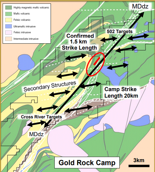
Dryden Gold’s (TSXV:DRY) exploration efforts in the Dryden Gold District with a strategy strengthened by notable stakeholders and modern exploration techniques, and aiming to unlock the potential of a historically underexplored region. With a land package covering over 50 kilometers of strike length along the Manitou-Dinorwic deformation zone, Dryden Gold is working to identify and discover high-grade gold mineralization. MiningFeeds spoke with the team at Dryden to get a more detailed picture of the company’s past, present, and future plans at the Dryden Gold District and beyond.
Rob McEwen, with his extensive experience in orogenic gold systems, particularly in Red Lake, brings valuable insights to Dryden Gold’s exploration approach. McEwen’s familiarity with the Kenwest property and his positive impression of the total property package assembled by Dryden Gold underline his support for the company’s efforts. “Rob owned the Kenwest property in the Goldcorp portfolio for many years so he is very familiar with the project and was impressed with the total property package we had put together. Because they were always busy at Red Lake and elsewhere, Kenwest never saw any exploration by Goldcorp, something Rob always regretted. Because Maura spent so much time at Red Lake, Rob was also impressed with her local knowledge and approach to the exploration program. He continues to be supportive and gives feedback on his updates,” Dryden Gold noted.
The Manitou-Dinorwic deformation zone, which the company’s land package covers, is geologically significant for high-grade gold mineralization. “The Manitou Dinorwic deformation zone has been compared to the Porcupine Destor Dz in Timmins, and the structural geology is very similar to Red Lake with the same repeating mineralized cross-cutting structures and regional folding creating traps for high-grade gold,” the company explained. The zone hosts high-grade gold occurrences across its 50-kilometer strike, evidenced by drilling, historic mining, ground samples, and trenching.
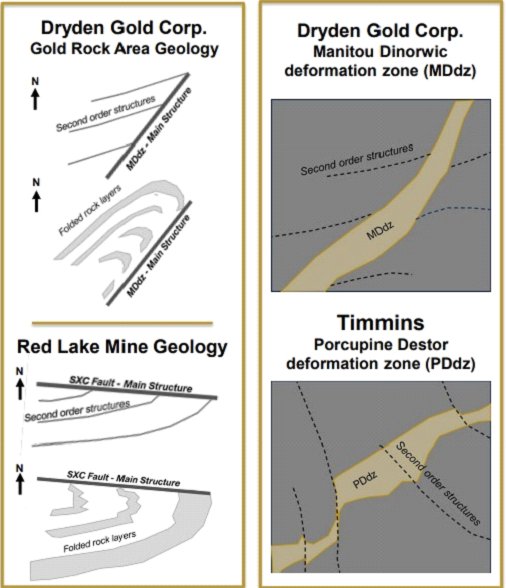
Dryden Gold’s Phase 4 drilling results from April 2024 were particularly promising. The Spring 2024 drill program had three specific goals: expanding the footprint of the known gold system, confirming the orientation and structural controls of the high-grade shoot on BM1, and testing the theory that sheared volcanics in the hanging wall and footwall carried gold mineralization. The 4,000 meters of drilling accomplished these goals, increasing the mineralized strike length of BM1 from 150 meters to over 1 kilometer and defining new high-grade shoots. “The Spring 2024 drill program (Phase 1-4) had three specific goals: to expand the footprint of the known gold system by identifying additional high-grade shoots, to confirm the orientation and structural controls of the known high-grade shoot on BM1 and test this to define additional high-grade shoots along strike on BM1 and on the parallel BM1 and Elora vein structures, and to test our theory that the sheared volcanics making up the hanging wall and footwall (which were not assayed by previous operators) did indeed carry gold mineralization,” Dryden Gold stated. Significant intersections included 26.11 gpt gold over 3.16 meters on BM1, and 53.51 gpt gold over 1.03 meters on the Elora vein structure.
The company is also relogging and resampling historic drill cores to expand the near-surface open pit mining potential at Gold Rock. “Relogging the historic core could significantly expand the near surface open pit mining potential at Gold Rock. Spot sampling by previous operators was contained mainly to obvious quartz vein structures. Also, logging by previous operators did not include defining the felsic dykes that our logging shows could be controlling high-grade gold mineralization. Re-logging will allow us to confirm these controls and begin to map the dykes to predict new high-grade shoots,” Dryden Gold noted.
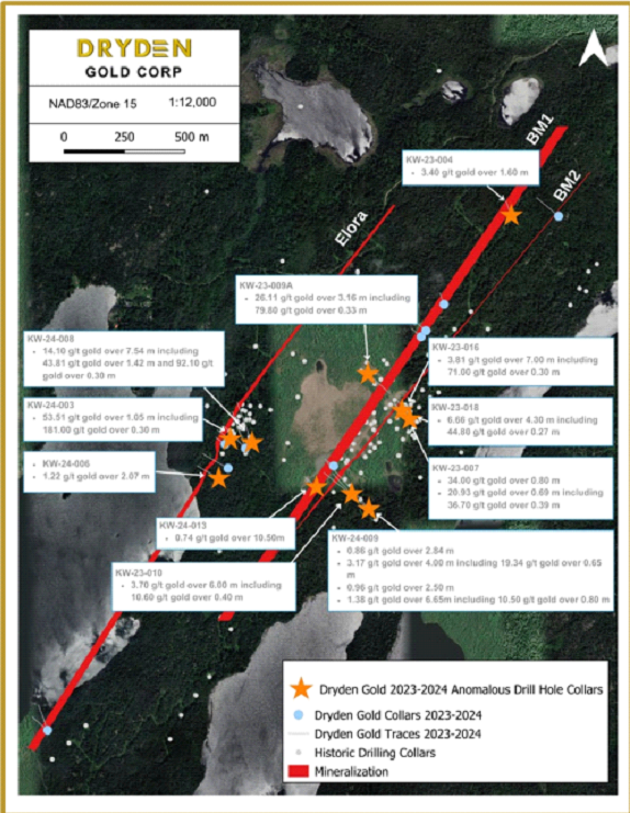
Dryden Gold is employing modern exploration techniques, including 3-D geophysics, LIDAR, complete assaying, and extensive logging, to unlock the potential of the underexplored Dryden Gold District. The consolidation of fragmented claims and the removal of heavy forest cover have facilitated exploration. “The reason for the limited exploration is two-fold: the claims have always been severely fragmented. Dryden Gold is the first company to have consolidated this strategic land package along this important MD dz. With that we are applying modern exploration techniques including 3-D geophysics, LIDAR, complete assaying and extensive logging,” the company explained.
Strategic shareholders like Alamos Gold and Eric Sprott contribute significantly to Dryden Gold’s overall strategy. Their experience in mining and long-term investment perspectives align with the company’s vision. “Their experience and history in mining is top-tier and they are long-term holders who see the tremendous potential and investment opportunity with Dryden Gold Corp,” Dryden Gold stated.
The company’s recent town hall meeting in March provided valuable updates on exploration and addressed investor questions, reinforcing confidence in Dryden Gold’s progress and future plans. Key takeaways included the relogging of 20,000 meters of historic core, a summer sampling program, and a fall drill program. “It was a successful town hall where investors understood the value of our approach moving forward with the near-term catalysts being a relogging and resampling summer program and a fall drill program,” Dryden Gold shared.
The presence of industry giants like Kinross, Agnico Eagle, New Gold, and Barrick Gold in the vicinity is seen as an advantage by Dryden Gold, providing potential synergies and collaborations. “Our property is a district-sized play in a robust near-surface high-grade gold setting. Exactly what majors and mid-tier producers require, and they are all watching our progress,” the company noted.
Clive Maund’s assessment of Dryden Gold as an “Immediate Strong Buy” reflects the company’s strong positioning and potential. Factors supporting this bullish outlook include experienced management, a strategic land position, high-grade gold intercepts, excellent infrastructure, and strong shareholders. “Experience management that has extensive regional experience as well as navigating M&A. Insiders own 12%. Strategic land position: dominant strategic land position Dryden Gold District, multiple high-grade gold intercepts near surface, geological setting similarities to Timmins Camps and Red Lake, excellent infrastructure, favourable mining jurisdiction, strong shareholders: Rob McEwen, Eric Sprott, Delwood Capital, EuroPac Gold Fund, Alamos Gold (largest shareholder), history of buyouts in the region (Great Bear, Rainy River and Hammond Reef),” Dryden Gold highlighted.
Dryden Gold’s strategic approach, combined with modern exploration techniques and strong industry partnerships, positions the company to capitalize on the untapped potential of the Dryden Gold District, which investors will be watching closely in the coming quarters.
The above references an opinion and is for information purposes only. It is not intended to be investment advice. Seek a licensed professional for investment advice. The author is not an insider or shareholder of any of the companies mentioned above.
If you would like to receive our free newsletter via email, simply enter your email address below & click subscribe.
 Follow us on Twitter
 Become our facebook fan
CONNECT WITH US
Tweets
Tweet with hash tag #miningfeeds or @miningfeeds and your tweets will be displayed across this site.
MOST ACTIVE MINING STOCKS
Daily Gainers
 CMC Metals Ltd. CMC Metals Ltd. |
CMB.V | +900.00% |
 Eden Energy Ltd Eden Energy Ltd |
EDE.AX | +200.00% |
| GoviEx Uranium Inc. |
GXU.V | +42.86% |
| Eagle Nickel Ltd. |
ENL.AX | +41.67% |
| Citigold Corp. Limited |
CTO.AX | +33.33% |
| Mount Burgess Mining NL |
MTB.AX | +33.33% |
| Exalt Resources Limited |
ERD.AX | +31.94% |
| Casa Minerals Inc. |
CASA.V | +30.00% |
| Cariboo Rose Resources Ltd |
CRB.V | +28.57% |
| Belmont Resources Inc. |
BEA.V | +28.57% |