In the world of copper mining, where sentiment can shift overnight, Solaris Resources (TSX:SLS) (OTCQB:SLSSF), with its Warintza copper project in southeastern Ecuador, stands as a beacon for immediate upside potential.
Solaris’ shares have taken a 65% hit since 2021 highs despite continuing to deliver amazing resource growth drill results and making significant new discoveries on the project. This is due to a number of factors weighing on shares including an upcoming Presidential election overhang, a slump in copper prices, macro weakness, coupled with Equinox unloading their SLS shares due to their own intensive capital spending needs. Analysts are confident that the worst is now over, forecasting $20 average target prices, and here’s why.
Ecuador’s Political Transition with Stable Mining Outlook
Despite upcoming elections, the country is a great place to operate offering a robust framework for mining investment with regulatory and tax stability and investment protection provided for in the form of an Investment Contract, which Solaris ratified in December 2022.
The country also boasts Latin America’s fastest permitting regime and lowest effective tax rates, even as other nations in the region grapple with growing discontent and rising taxes. Ecuador is a US dollar economy with minimal inflation and solid existing infrastructure, which translates to lower capital intensity.
Recently, Wheaton Precious Metals made a strategic $300 million purchase of a gold stream for Lumina Gold’s Cangrejos Project in Ecuador. The specifics of this deal may not be directly relevant to copper, but it certainly casts light on the mining landscape in Ecuador. As the country prepares for an upcoming presidential election, the deal proves Ecuador’s mining sector’s resilience and continued appeal.
In this climate, WPM’s $300 million investment in an Ecuadorian company that has a market cap of $200 million and requires an additional billion to grow is indicative of confidence in the country’s mining regime.
Warintza: A Golden Goose
Solaris’ Warintza Project is world-class by any measure. With limited high-quality copper assets remaining, Warintza offers a tantalizing proposition to copper bulls. Positioned in a region rich with undeveloped copper porphyries with access to nearby primary infrastructure, the location alone is enough to turn heads.
Solaris issued a 43-101 resource in April 2022 for the Warintza Central deposit of 1.5 billion tonnes of copper at a CuEq grade of 0.5% including a high-grade starter pit of 287 million tonnes at a CuEq grade of 0.8%.
Over the last 18 months, the deposit has significantly grown with an updated mineral resource expected around year-end to incorporate new drilling with an expected resource growing to 2-3 billion tonnes.
What’s most important to the company is: 1) all new drill holes encountered mineralization at or near-surface which is rare amongst copper development assets, and (2) drilling continues to intersect grades in-line with the most recent 43-101 resource – the same resource that once had SLS trading at 2x its current levels
Most recently, the company announced two new discoveries on the project, known as Patrimonio and Warintza Southeast, both located just outside the 43-101 resource offering major growth potential once again bringing the grand total to six major deposits within the Warintza porphyry cluster. This follows after the original Warintza Central deposit discovered by the late David Lowell in 2000, and Solaris discoveries at Warintza West (February 2021), Warintza East (July 2021), and Warintza South (January 2022). Sulphide minerals at Patrimonio include pyrite, chalcopyrite, and molybdenite, with total sulphide abundances up to 10% – as much as two times higher than previously logged at Warintza Central, where the majority of the resource is located.
Valuation Disconnect
With analyst consensus on the current 43-101 resource showing a net present value (NPV) of $4.0 billion at an 8% discount rate, and a current SLS market cap of $620 million, the price to net asset value (P/NAV) stands at a mere 0.2x. Even for cautious investors, the downside risk at this valuation seems remarkably low, especially before the updated resource due at year-end. The strategic value of high-grade copper tonnage at surface with minimal strip seems to be ignored by the market presenting an attractive opportunity for buyers seeking a high-reward, low-risk asset.
The above references an opinion and is for information purposes only. It is not intended to be investment advice. Seek a licensed professional for investment advice. The author is not an insider or shareholder of any of the companies mentioned above.
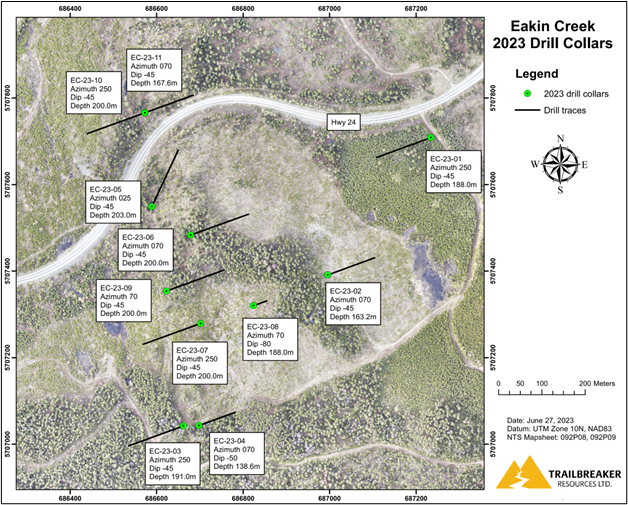
Trailbreaker Resources Ltd. (TSXV:TBK) has completed the inaugural diamond drilling exploration at the Eakin Creek gold property in south-central British Columbia (BC). The property, which is wholly owned by Trailbreaker, was subject to a rigorous diamond drilling campaign from May 24 to June 20, 2023.
Daithi Mac Gearailt, CEO of Trailbreaker, commented in a press release: “This was a very well executed program and provided great coverage of our target area. The drill program went over the planned meterage and stayed under budget. I would like to thank our drill contractor, Paycore Drilling, for helping achieve our goals at Eakin Creek.”
Despite planning for 2,000 meters, the company drilled a total of 2,039 meters across eleven distinct diamond drill holes. These holes spanned 750 meters of strike length and reached 800 meters across the strike. Trailbreaker’s team on-site managed the logging and splitting of the NQ-sized drill core, which was subsequently sent to Bureau Veritas in Vancouver for analysis.
Trailbreaker designed the program to investigate both induced polarization (IP) and geochemical anomalies, detected during the 2022 exploration program. It also sought to explore multiple surface gold showings discovered within these anomalies. The analysis results from this exploration are yet to be disclosed.
The Eakin Creek property is situated 100 kilometers north of Kamloops, BC. It is accessible via Highway #24 and through a network of well-kept forest service roads. The property spans 1,610 hectares of terrain with potential for gold, located in the region that drains into the gold-rich Eakin Creek.
Historical factors motivated Trailbreaker’s acquisition of this target. Notably, the historic ‘G Occurrence’ was found on the highway, one of the rare exposed outcroppings on the property. There were also fields of gold-bearing boulder samples, presumed to be local, and an assembly of some of the highest gold-in-till values from regional sampling in BC.
In 2022, Trailbreaker conducted a 10.75 line-kilometer IP survey and a 302-sample Mobile Metal Ion (MMI) soil survey. It also performed prospecting. A 1,000 x 600-meter area presented an Au-Ag-Cu-Sb (gold-silver-copper-antimony) soil anomaly aligning with an IP geophysical anomaly. Furthermore, extensive gold mineralization was identified in bedrock and float samples. The 2023 drilling scheme was formulated to scrutinize this area meticulously.
The above references an opinion and is for information purposes only. It is not intended to be investment advice. Seek a licensed professional for investment advice. The author is not an insider or shareholder of any of the companies mentioned above.
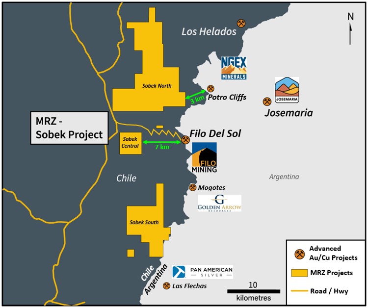
Mirasol Resources (TSXV:MRZ) has reported that the 2022/23 exploration program at the Sobek Copper-Gold Project in the Vicuña Copper-Gold-Silver District of Chile has seen significant progress. The company, which owns 100% of Sobek, announced the completion of an airborne Mobile MT survey and the initiation of the first drilling program at the site.
The initial decision to stake Sobek was based on the local structural architecture’s potential, which proved promising when high-grade feeder zones were discovered at the Filo del Sol gold-copper deposit 7 km to the east and NGEx Minerals discovery at Potro Cliffs 3 km to the east in 2021.
The Sobek project, staked in 2016, is located in an area known for its geological potential. Covering a massive 11,120 hectares in three strategic locations within the Vicuña District, Sobek is surrounded by numerous deposits including Filo del Sol, Potro Cliffs, the Josemaria copper-gold project, Los Helados Porphyry, and the massive El Morro Porphyry copper-gold deposit.
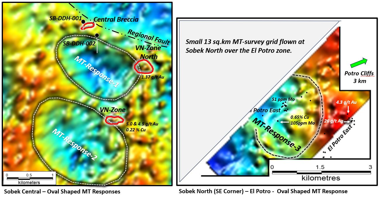
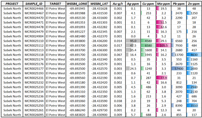
“The potential for discovery at the high-profile Vicuña Copper-Gold district has motivated us to advance Sobek from initial boots-on-the-ground exploration to the maiden drill campaign at an extraordinary pace. We will maintain this momentum and plan to continue drilling as soon as the weather allows for access in just a few months,” Mirasol’s President Tim Heenan stated. “The recently completed airborne Mobile MT survey returned multiple compelling geophysical responses coincident with geochemical anomalies and encouraging geological observations with clear evidence of advanced stage hydrothermal activity and alteration. Impressive precious and base metals results, including new multi-gram gold results from select rock grab samples at both the Sobek Central VN-Zone and Sobek North El Potro Zone elevate the importance of both target areas which will be prioritized when drilling resumes.”
The successful completion of a 500-line km Airborne Mobile MT survey, which covered the entire Sobek Central area, has provided high-definition depth penetration to over 800m below surface. This method has previously proven effective in identifying targets in high-sulfidation epithermal (HSE) and porphyry systems elsewhere in Chile. The survey pinpointed a remarkable cluster of MT anomalies in areas adjacent to the Central Breccia zone, which are thought to represent intrusive centers. The initial focus of the maiden drill campaign was these MT targets at Sobek Central.
The inaugural drill campaign at Sobek Central was initiated based on the results of the Mobile MT survey, geochemical soil anomalies, and select surface rock chip results. Two holes were drilled with depths of 352m and 586m respectively before winter weather conditions forced a halt. Additional drilling will be needed for both targets, with the VN-Zone targeted as a priority once drilling resumes later in the year.
Prospecting results from the VN-Zone at Sobek Central have continued to show high gold grades, with up to 5.0 g/t gold and 2200 ppm copper found in recent samples. Furthermore, new mineralized veins were exposed near the VN-Zone, with samples containing up to 1.37 g/t gold and 663 ppm copper.
At the El Potro East Zone of Sobek North, mineralization has been extended to the east and is now within 3 km of NGEx’s recent discovery at the Potro Cliffs project in Argentina. The zone appears to host an area of “lithocap type” alteration and mineralization, and select rock chip samples have returned values ranging from 0.10 to a high of 4.3 g/t gold with associated silver from 0.30 up to– 25.9 g/t.
This successful exploration program continues to highlight the potential of the Sobek project and its potential to contribute significantly to Mirasol Resources’ future success. The company looks forward to resuming the drilling campaign in the coming months.
Highlights from the update are as follows:
- Sobek is located 7 km directly west of Filo Mining’s Filo del Sol Project and 3 km from NGEx´s new discovery at Potro Cliffs
- 500-line kilometer Airborne Mobile MT geophysical survey completed over Sobek Central and Sobek North
- Compelling high-priority drill targets outlined by the Airborne Mobile MT survey coincident with geochemical anomalies and select high-grade surface samples
- Maiden drill campaign advances, testing first of several priority targets – two holes for a total of almost 950m completed
Table 1: Updated Anomalous Gold in Select Rock Samples from the VN Zone
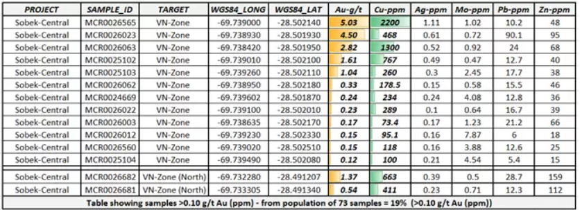
Table 2: Updated Sobek North – El Potro East Select Rock Chip Grab Sample Geochemical Results
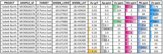
Table 3: Updated Sobek North – El Potro West Select Rock Chip Grab Sample Geochemical Results
The above references an opinion and is for information purposes only. It is not intended to be investment advice. Seek a licensed professional for investment advice. The author is not an insider or shareholder of any of the companies mentioned above.
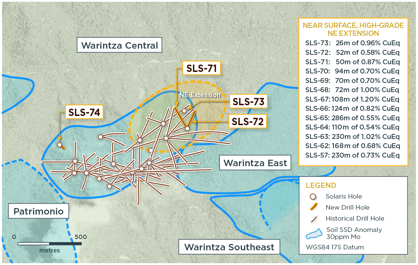
Solaris Resources Inc. (TSX:SLS) (OTCQB:SLSSF) has recently reported its assay results from a sequence of drillings focused on expanding the ‘Indicative Starter Pit’ within the Warintza Central zone at the Warintza Project, located in southeastern Ecuador. The goal of the drilling is to enlarge the near-surface, high-grade mineralization estimated at 180 Mt at 0.82% CuEq (Indicated) and 107 Mt at 0.73% CuEq¹ (Inferred) in the Warintza Mineral Resource Estimate.
The results show that recent drilling has successfully expanded the Northeast Extension zone to the north-northeast. Future plans include more step-out drilling in this direction. Meanwhile, a considerable step-out of 250 meters on the opposite side of Warintza Central has increased the zone towards the northwest, unveiling new potential areas for mineral resource growth. Drilling to expand the ‘Indicative Starter Pit’ is still ongoing, with the company aiming to further increase the mineral resource potential of the site.
Highlights from the results are as follows:
- SLS-72 was collared from a newly-constructed step out platform 200m to the northeast, returning 268m of 0.60% CuEq¹ within a broader interval of 830m averaging 0.50% CuEq¹ from 48m depth, extending the zone to the northeast where it remains open
- SLS-71 was collared from the same platform within the northeast extension zone and drilled northwest into a partially open volume, returning 212m of 0.60% CuEq¹, including 50m of 0.87% CuEq¹, within a broader interval of 494m of 0.42% CuEq¹ from near surface
- SLS-73 was collared from another newly-constructed step out platform 250m to the north, returning 26m of 0.96% CuEq¹ from near surface and 128m of 0.60% CuEq¹ within a broader interval, extending the zone to the northeast where it remains open
- These three holes expand the Northeast Extension zone to the east and northeast where two additional 200m step-out platforms have been planned for construction to test the potential extension of the zone beneath shallow saprolitic cover
- On the opposite side of Warintza Central, SLS-74 was collared from a newly-constructed platform stepping out 250m to the northwest of the existing drill grid to test the potential extension of high grade, near surface mineralization – it returned 54m of 0.80% CuEq¹ from surface within a broader interval of 224m of 0.41% CuEq¹
- SLS-74 includes lower grade mineralization within a porphyritic granodiorite modelled as the northwestern contact of Warintza Central – ongoing mapping and sampling aims to assess the potential for better-developed mineralization higher up in this intrusive phase in the 700m gap to Warintza West
- Additional assays are expected soon from drilling targeting further growth at Warintza East, follow-up drilling at the recent high-grade Warintza Southeast discovery and the new Patrimonio discovery
Table 1 – Assay Results
| Hole ID | Date Reported | From (m) | To (m) | Interval (m) | Cu (%) | Mo (%) | Au (g/t) | CuEq¹ (%) |
| SLS-74 | June 28, 2023 | 6 | 230 | 224 | 0.28 | 0.03 | 0.04 | 0.41 |
| Including | 6 | 60 | 54 | 0.59 | 0.05 | 0.07 | 0.80 | |
| Including | 120 | 230 | 110 | 0.22 | 0.03 | 0.03 | 0.38 | |
| SLS-73 | 12 | 228 | 216 | 0.40 | 0.02 | 0.11 | 0.53 | |
| Including | 26 | 52 | 26 | 0.83 | 0.01 | 0.13 | 0.96 | |
| Including | 100 | 228 | 128 | 0.45 | 0.02 | 0.12 | 0.60 | |
| SLS-72 | 48 | 878 | 830 | 0.39 | 0.02 | 0.08 | 0.50 | |
| Including | 48 | 100 | 52 | 0.50 | 0.01 | 0.08 | 0.58 | |
| Including | 610 | 878 | 268 | 0.47 | 0.02 | 0.08 | 0.60 | |
| SLS-71 | 30 | 524 | 494 | 0.33 | 0.01 | 0.08 | 0.42 | |
| Including | 54 | 266 | 212 | 0.47 | 0.02 | 0.09 | 0.60 | |
| Including | 54 | 104 | 50 | 0.76 | 0.02 | 0.10 | 0.87 |
Notes to table: True widths of the mineralized zone are not known at this time.
Table 2 – Collar Location
| Hole ID | Easting | Northing | Elevation (m) | Depth (m) | Azimuth (degrees) | Dip (degrees) |
| SLS-74 | 799558 | 9648247 | 1325 | 236 | 130 | -80 |
| SLS-73 | 800531 | 9648518 | 1262 | 294 | 0 | -90 |
| SLS-72 | 800552 | 9648378 | 1358 | 878 | 25 | -80 |
| SLS-71 | 800552 | 9648378 | 1358 | 568 | 330 | -70 |
| Notes to table: The coordinates are in WGS84 17S Datum. | ||||||
Endnotes
- Copper-equivalence calculated as: CuEq (%) = Cu (%) + 4.0476 × Mo (%) + 0.487 × Au (g/t), utilizing metal prices of US$3.50/lb Cu, US$15.00/lb Mo, and US$1,500/oz Au, and assumes recoveries of 90% Cu, 85% Mo, and 70% Au based on preliminary metallurgical test work. The ‘Indicative Starter Pit’ is based on the same assumptions as the MRE except utilized metal prices of US$1.00/lb Cu, US$7.50/lb Mo, and US$750/oz Au. The ‘Indicative Starter Pit’ is comprised of Indicated mineral resources of 180 Mt at 0.82% CuEq (0.67% Cu, 0.03% Mo, 0.07 g/t Au) and Inferred mineral resources of 107 Mt at 0.73% CuEq (0.64% Cu, 0.02% Mo, 0.05 g/t Au) above a 0.6% CuEq cut-off grade. No economic analysis has been completed by the Company and there is no guarantee an ‘Indicative Starter Pit’ will be realized or prove to be economic.
- Refer to Solaris’ technical report titled, “NI 43-101 Technical Report for the Warintza Project, Ecuador” with an effective date of April 1, 2022, prepared by Mario E. Rossi and filed on the Company’s SEDAR profile at www.sedar.com.
- For additional details on “Near Surface, High-Grade, NE Extension” intervals, refer to press release dated May 26, 2022 for SLS-57: 230m of 0.73% CuEq (0.59% Cu, 0.03% Mo, 0.08 g/t Au), refer to press release dated July 20, 2022 for SLS-62: 168m of 0.68% CuEq (0.51% Cu, 0.03% Mo, 0.07 g/t Au) and SLS-63: 230m of 1.02% CuEq (0.87% Cu, 0.02% Mo, 0.12 g/t Au), refer to press release dated September 7, 2022 for SLS-64: 110m of 0.54% CuEq (0.38% Cu, 0.04% Mo, 0.03 g/t Au) and SLS-66: 124m of 0.82% CuEq (0.71% Cu, 0.02% Mo, 0.09 g/t Au) and SLS-67: 108m of 1.20% CuEq (1.06% Cu, 0.03% Mo, 0.09 g/t Au), refer to press release dated December 5, 2022 for SLS-65: 286m of 0.55% CuEq (0.38% Cu, 0.04% Mo, 0.06 g/t Au) and SLS-68: 72m of 1.00% CuEq (0.88% Cu, 0.02% Mo, 0.06 g/t Au), refer to press release dated Mar 13, 2023 for SLS-69: 70m of 0.70% CuEq (0.56% Cu, 0.03% Mo, 0.06 g/t Au) and SLS-70: 94m of 0.70% CuEq (0.53% Cu, 0.03% Mo, 0.11 g/t Au).
The above references an opinion and is for information purposes only. It is not intended to be investment advice. Seek a licensed professional for investment advice. The author is not an insider or shareholder of any of the companies mentioned above.
Vancouver-based B2Gold Corp. (TSX:BTO) is stepping into Canadian mining market with its first project in the country, investing nearly C$2 billion in a mine in southwestern Nunavut.
Prior to this, B2Gold’s mining operations were entirely international, with active sites in Mali, Namibia, and the Philippines. This year, however, marked a strategic shift for the company. In April, B2Gold acquired Sabina Gold and Silver Corp. along with its Back River Gold District in Nunavut for a reported C$1.2 billion.
The Back River Gold District spans an 80-kilometre belt featuring six gold properties. Among these, the Goose property is currently under development. B2Gold has announced plans for the Goose deposit, aiming to manage it as a combined open pit and underground operation. The property is recognized as one of the highest-grade undeveloped gold properties globally, as per a B2Gold investor presentation.
The company’s latest construction update revealed a budget of C$890 million for the new mine. Over the winter, B2Gold transported the necessary construction equipment to the site via an ice road. The company is also building a mill, expected to be operational by the first quarter of 2025.
B2Gold had initially projected a capital expenditure of C$800 million for the project, but recently decided to invest an additional C$90 million. This increased funding aims to hasten underground mining operations to boost the mine’s annual gold production during its first five years. The company anticipates an average annual production of around 300,000 ounces per year.
As of 2020, B2Gold operates three mines: the Fekola mine in Mali, the Masbate mine in the Philippines, and the Otjikoto mine in Namibia. The Fekola mine is the company’s largest, producing over 400,000 ounces of gold each year. The Masbate mine, an open-pit mine, produces upwards of 200,000 ounces of gold annually, while the Otjikoto mine, a combined open pit and underground mine, produces between 150,000 and 200,000 ounces of gold annually.
The above references an opinion and is for information purposes only. It is not intended to be investment advice. Seek a licensed professional for investment advice. The author is not an insider or shareholder of any of the companies mentioned above.
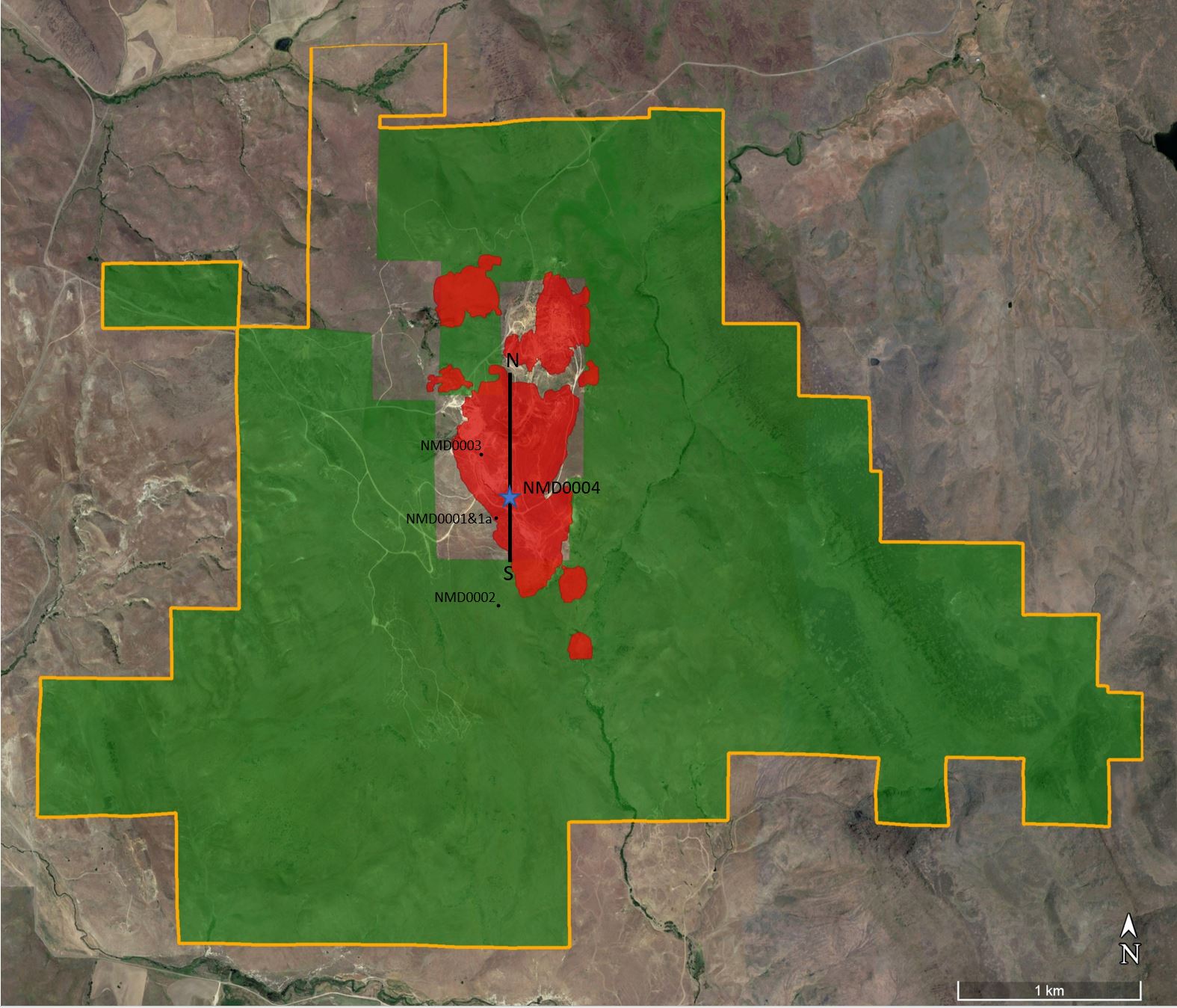
NevGold Corp. (TSXV:NAU) has reported additional oxide gold findings at the Nutmeg Mountain gold project in Idaho. The 2020 historical mineral resource estimate listed at the site was 910,000 indicated ounces of gold (43.5 Mt @ 0.65 g/t Au) and 160,000 inferred ounces of gold (9.1 Mt @ 0.56 g/t Au). NevGold noted that this historical estimate has not been updated due to insufficient work by a qualified person, so it is not currently classified as a mineral resource or mineral reserve.
Additionally, the company is nearing the completion of a current Mineral Resource Estimate (MRE) at Nutmeg Mountain, anticipated by early July.
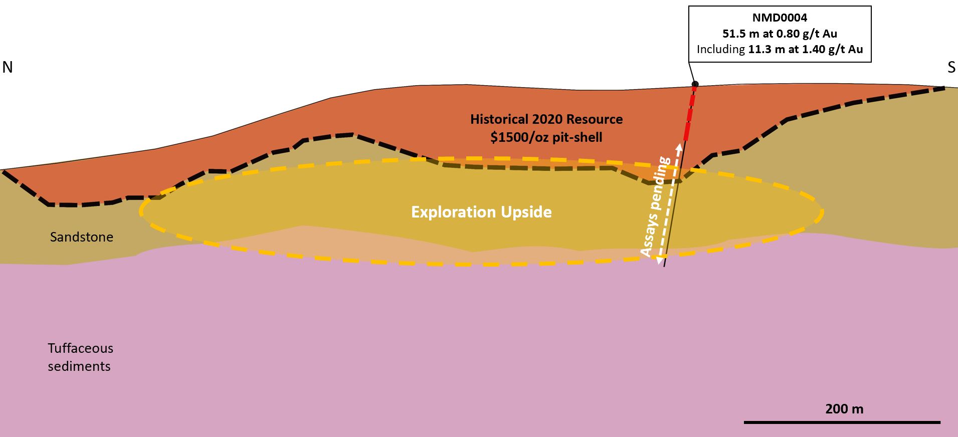
NevGold CEO, Brandon Bonifacio, commented in a press release: “The further results from our inaugural drill program at Nutmeg Mountain continue to highlight the at-surface, oxide gold mineralization at the project that we anticipate will be amenable to heap leach processing. Drillhole NMD0004 will also be utilized for the commencement of metallurgical testwork with focus on optimization opportunities in the grinding and comminution area. We are looking forward to the remaining approximate 130 meters of assays pending from Drillhole NMD0004, which is at the assay lab undergoing further testwork. We are also pleased to announce that we are advanced in completing a current Mineral Resource Estimate at Nutmeg Mountain, with targeted completion in early July. Nutmeg Mountain is one of very few oxide gold, heap-leach projects of scale and grade with mineralization starting at surface in the Western USA.”
Among the key findings reported, gold was intercepted from the surface, indicating the project may be suitable for heap leach processing. NevGold reported an intercept of 0.80 g/t Au over 51.5 meters from the surface, which includes 1.40 g/t Au over 11.3 meters from a depth of 9.8 meters (Hole NMD0004). Pending are assays for the remaining 130 meters of the hole.
The company has also begun metallurgical testing at the site, employing McClelland Laboratories from Sparks, Nevada. The tests are set to explore optimization opportunities regarding grinding, comminution, and recovery methods.
Further results from the 2023 drilling program denote a large, near-surface mineralized footprint. For instance, 0.72 g/t Au was found over 79.3 meters from 10.4 meters depth (Hole NMD0003), and 0.56 g/t Au over 23.9 meters from 24.1 meters depth (Hole NMD0001).
The orientated core drilling part of the program is now complete and will be transitioning to Reverse Circulation (RC) drilling. NevGold is also progressing towards a current Mineral Resource Estimate (MRE) at the Nutmeg Mountain site, with a targeted completion date in early July.
Highlights from the results are as follows:
Drill Results
| Hole ID | Length, m* | g/t Au | From, m | To, m | Comment |
| NMD0001** | 23.9 | 0.56 | 24.1 | 48.0 | hole terminated in mineralization |
| including | 11.4 | 0.89 | 25.6 | 37.0 | |
| NMD0001a** | 53.3 | 0.20 | 29.0 | 82.3 | poor core recovery |
| NMD0001a** | 24.2 | 0.28 | 135.2 | 159.4 | poor core recovery |
| NMD0002** | 10.0 | 0.16 | 4.8 | 14.8 | intercepted up to 0.43 g/t Au down to 93.6m |
| NMD0003** | 79.3 | 0.72 | 10.4 | 89.6 | |
| including | 13.4 | 2.32 | 25.6 | 39.0 | |
| NMD0004 | 51.5 | 0.80 | 0.0 | 51.5 | |
| including | 11.3 | 1.40 | 9.8 | 21.0 | |
| 128.5 | pending | 51.5 | 180.0 | Assays pending |
* Downhole thickness reported; true width varies depending on drill hole dip and is approximately 70% to 90% of downhole thickness. All holes were completed with core drilling. Any apparent errors in arithmetic are due to rounding.
** Assays released on April 13, 2023.
Updated Mineral Resource Estimate
The Company has engaged Global Mineral Resource Services from North Vancouver, Canada to complete the MRE at Nutmeg Mountain. Targeted completion of the MRE is early July.
Geology Summary
Hole NMD0004 was a metallurgical drillhole and based on the core logging completed, the hole shows strong oxidation in the mineralized zone. The hole was split into quarters, and part of the hole was sent to McClelland Laboratories in Sparks, Nevada to commence metallurgical testwork. The focus of the new testwork program is to systematically augment the historical metallurgical data with focus on grinding, comminution, and optimal recovery methods.
The remainder of assays from Hole NMD0003 were received. Along with the previously announced 0.72 g/t Au over 79.3 meters from 10.4 meters depth, the hole contained multiple zones of anomalous mineralization with grades up to 0.61 g/t Au. The textures and alterations logged in the core exhibit positive characteristics and highlight that the Company is vectoring in on the potential high-grade feeder structure at the Project. More core drilling will be incorporated into further drilling at the Project in 2023.
Drillhole Orientation Details
| Hole ID | Azimuth degrees | Dip degrees | Total Depth feet | Total Depth meters |
| NMD0001 | 95 | 55 | 157.5* | 48.0* |
| NMD0001a | 95 | 55 | 1498.5* | 456.7* |
| NMD0002 | 85 | 45 | 587 | 178.9 |
| NMD0003 | 130 | 70 | 1656.5 | 504.9 |
| NMD0004 | 350 | 80 | 599 | 182.6 |
* Did not reach target depth.
Sampling Methodology, Chain of Custody, Quality Control and Quality Assurance: All sampling was conducted under the supervision of the Company’s geologists and the chain of custody from the Project to the independent sample preparation facility, American Assay Labs in Sparks, NV, was continuously monitored. The samples were crushed, pulverized and sample pulps were analyzed using industry standard fire assay methods. A blank and certified reference material was inserted approximately every 20th sample and duplicates of coarse reject material was analyzed approximately every 20th sample. Data verification of the analytical results included a statistical analysis of the standards and blanks that must pass certain parameters for acceptance to ensure accurate and verifiable results.
Note 1: Nutmeg Mountain – Historical 2020 Mineral Resource
On July 14, 2020, GoldMining Inc. (TSX:GOLD, NYSE:GLDG) (“GoldMining”) published an NI 43-101 technical report on the Project titled “Technical Report – Almaden Gold Property”, with an effective date of April 1, 2020, which includes the following, and which NevGold is treating as a Historical Mineral Resource Estimate:
Nutmeg Mountain – GoldMining 2020 Mineral Resource Estimate
| Classification | Cutoff Grade Au g/tonne |
Tonnes | Gold Grade g/tonne |
Ounces Gold |
| Indicated | 0.30 | 43,470,000 | 0.65 | 910,000 |
| Inferred | 0.30 | 9,150,000 | 0.56 | 160,000 |
Table 1: Mineral Resource from GoldMining’s NI 43-101 technical report filed on SEDAR on July 14, 2020
The Historical Mineral Resource Estimate is believed to be reliable and relevant and professionally calculated under the assumptions made in 2020. A Nevgold Qualified Person has not done sufficient work to classify GoldMining’s Mineral Resource Estimate as current mineral resources, and NevGold is not treating the estimate as current mineral resources or mineral reserves. The current NevGold drilling and geological work is considered sufficient to allow for NevGold to complete an updated Mineral Resource Estimate at the Project.
The above references an opinion and is for information purposes only. It is not intended to be investment advice. Seek a licensed professional for investment advice. The author is not an insider or shareholder of any of the companies mentioned above.
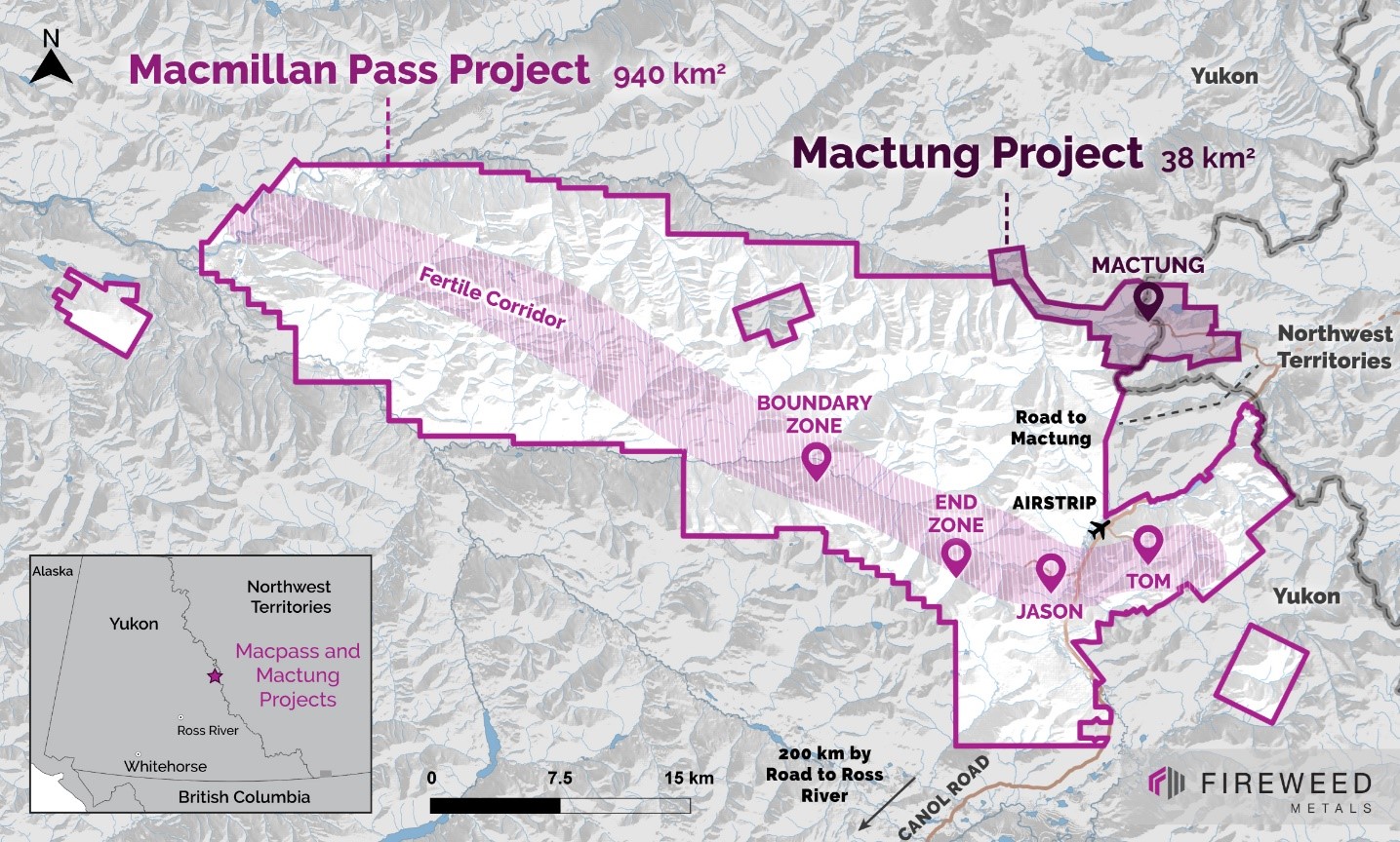
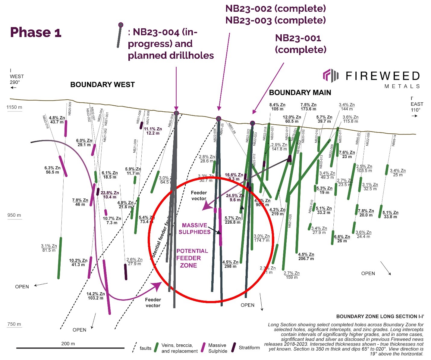
Fireweed Metals (FWZ:TSXV) has reported on the progress of its 2023 exploration program, including results from its first three drillholes. These exploratory drillings in the area bridging the Boundary Main and Boundary West zones have discovered significant zinc-lead mineralization. The corporation is on track to finish a 1,900 m Phase 1 drill program and has plans to conduct at least an additional 14,000 m of drilling across several step-outs and targets this year.
Brandon Macdonald, CEO of Fireweed Metals, commented in a press release: “The season is off to a thrilling start, with a broad intersection of massive sulphides in a step-out hole at Boundary Zone as part of the first test of our feeder zone target. We are very excited that we have hit zinc-lead mineralization in all our first three holes at Boundary Zone, stepping out from our discoveries in 2022. Progress has gone well on the 2023 exploration campaign with the first rig making very good production and we have capitalized on the relatively early snowmelt to mobilize a second rig ahead of schedule. The imminent completion of our new 48-person, all-weather camp will facilitate exploration in 2023 and beyond.”
Fireweed’s 2023 exploration plan is set to operate five diamond drill-rigs, aiming for over 16,000 m of drilling in the Boundary, Tom, and Jason zones. Over 1,400 m of the anticipated 1,900 m Phase 1 drilling has already been carried out. Phase 2 will extend the drilling by around 14,000 m. Both phases are focused on drilling step-out holes around areas identified to contain significant amounts of zinc-lead-silver mineralization.
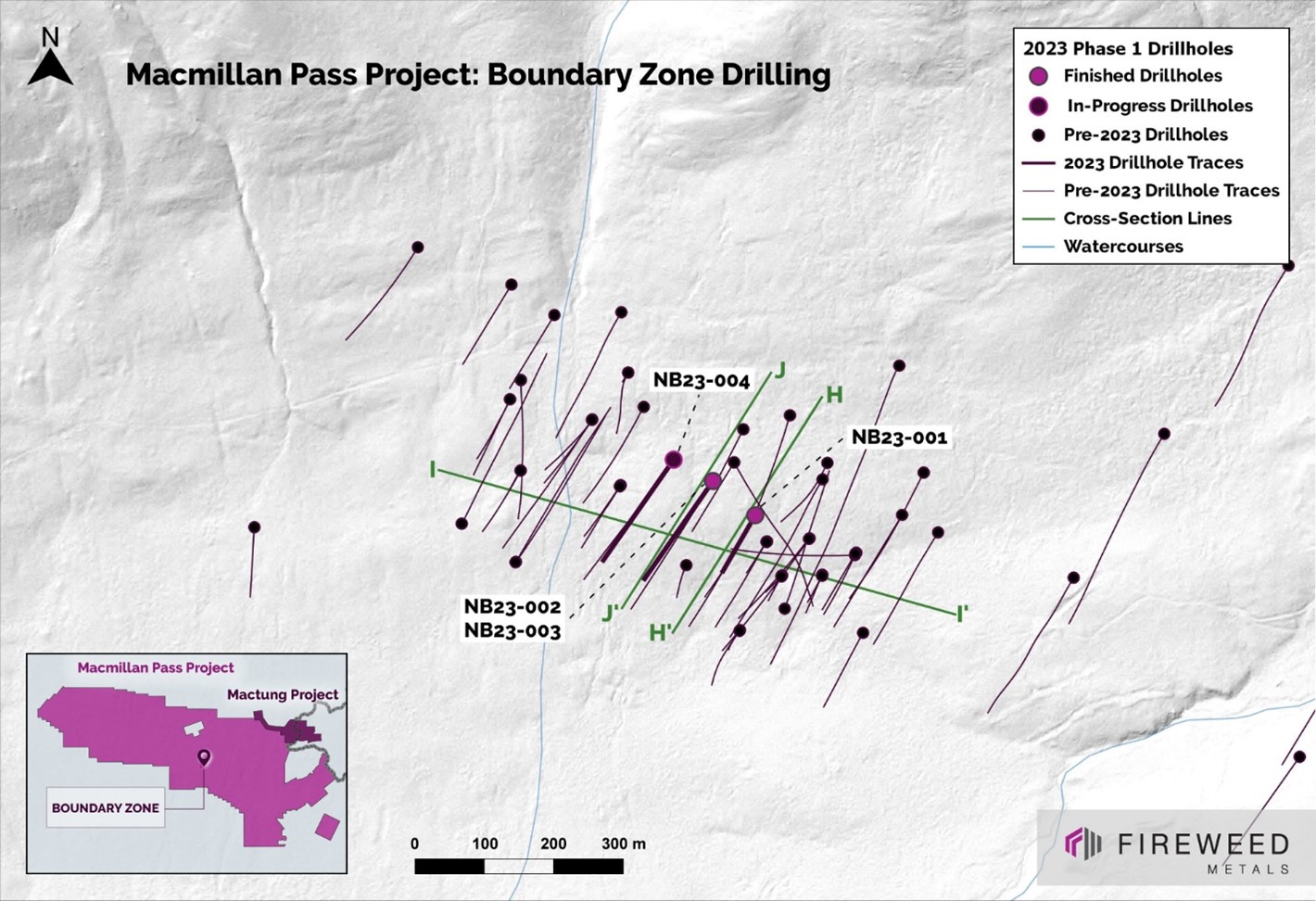
Fireweed’s inaugural phase of the 2023 drilling program targets a gap between its two top-performing drillholes at the Boundary Zone – NB22-002 and NB22-023. The corporation envisages a potential high-grade feeder zone in this area that could connect Boundary West and Boundary Main. The drillholes from 2022 revealed substantial high-grade zones on either side of the Phase 1 target area. Notably, the NB22-023 hole found 298 m of 4.5% zinc, 1.4% lead, and 30.9 g/t silver, including a new 9.6 m stratiform zone grading 24.5% zinc, 15.1% lead, and 323.2 g/t silver. Meanwhile, the NB22-002 hole intersected 124 m at 12.3% zinc, 1.3% lead, and 45.9 g/t silver.
The 2023 step-outs completed thus far have successfully intersected sphalerite and galena mineralization in forms of stratiform massive sulphides, replacement mineralization, veins, and breccias. Hole NB23-003 intersected 73 m of massive sulphide, marking the first intersection of the proposed feeder zone target. The ongoing Phase 1 program will continue to test the mineralized layers and the potential feeder area linking Boundary Main and Boundary West.
The initial three drillholes were completed over 50% faster than previous operations. An early snowmelt this year enabled an extra rig to be mobilized sooner than expected. Drilling began on June 18th, and three more drills will be transported by truck this week, reaching the total of five rigs as planned. The drilling will target significant step-outs at Tom, Jason, Boundary Zone, and further.
The camp, currently hosting almost 50 people, is functioning smoothly. Construction of a new 48-person camp expansion is well underway, with commissioning and first occupants expected by the end of the month. Alongside the existing camp, the new all-weather facility will support about 100 people on site to fulfill the 2023 season’s objectives. This expansion is a crucial step in reaching the approved capacity of 150 people at the Macmillan Pass camp, enabling larger drill programs and concurrent environmental baseline studies even during colder months.
Highlights from the update include:
- A 73 m wide interval of massive sulphide zinc-lead mineralization has been intersected at Boundary Zone and is open along-strike and at depth, validating the feeder zone target, with plans for step-out holes in the interpreted direction towards the feeder.
- All three of the first drillholes at Boundary Zone have hit zinc-lead mineralization.
- Results indicate that the Boundary West and Boundary Main zones may be connected parts of a single mineralized system.
- The second of five drill rigs is now at site and has started drilling at the Tom deposit.
- Drilling will target step-out holes at Tom, Jason, and Boundary Zone.
The above references an opinion and is for information purposes only. It is not intended to be investment advice. Seek a licensed professional for investment advice. The author is not an insider or shareholder of any of the companies mentioned above.
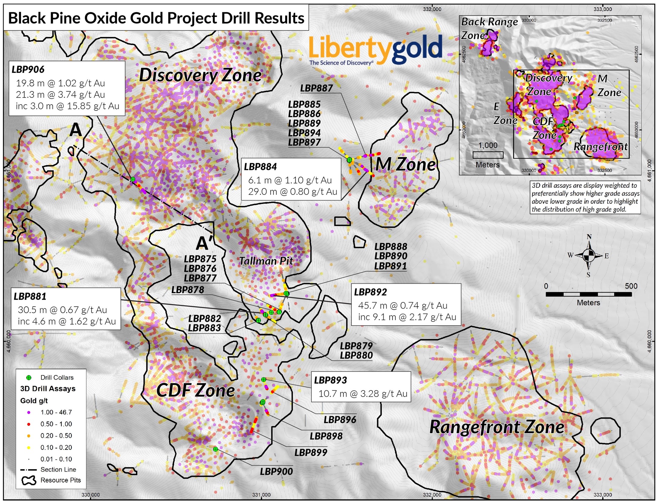
Liberty Gold (TSX:LGD), has reported promising new assay results from the ongoing 2023 Reverse Circulation (RC) drilling scheme at the prestigious Black Pine Oxide Gold Project in southeastern Idaho.
Jason Attew, President and CEO of Liberty Gold commented in a press release: “We are excited to have found high-grade mineralization in a sparsely drilled area within our resource model, which has implications for resource expansion across the project area. We are working hard on the modeling in anticipation of a further resource update at the end of this year.”
Covering 15,000 meters out of the scheduled 32,000 meters of RC drilling for this year, Liberty Gold has made significant strides in its exploration. To expedite the drilling results for the latter half of the year, the company has introduced a third RC rig this June. The proactive move precedes an anticipated updated mineral resource estimation needed to back a Pre-Feasibility Study (PFS).
The recent drilling endeavour is concentrated on multiple zones: the Back Range Zone, Discovery Zone, M Zone West, and the notable CD-Tallman ‘corridor.’ The venture includes testing the historic surface waste rock dumps within this corridor.
In the Discovery Zone, one of the standout highlights includes results from LBP906, showing an impressive 3.74 grams per tonne gold over 21.3 meters, with a notable 15.85 g/t Au over 3.0 meters. Astonishingly, assays for LBP906 have brought back outstanding oxide gold results from an area that was formerly modelled as waste rock. An additional four holes in the same area are pending results.
The primary aim of the 2023 infill drill program is to convert ounces currently categorized as inferred into the indicated classification and to ensure no gaps in the drill coverage along the edges of the resource pits. To this end, one drill is targeting additional holes next to the Discovery Zone, where a substantial gap in drill coverage at depth is observed. Preliminary visuals from this drilling venture look promising, with assay results pending.
Drilling activities in the CD-Tallman Corridor have provided some intriguing highlights too. Assay outcomes from 18 RC holes in this area show that a significant chunk of the surface waste backfill material contains gold above a 0.1 g/t Au cut-off. Particularly encouraging is the finding of localized zones with as high as 8.58 g/t Au of oxide material in hole LBP893. Further drilling efforts are underway to better characterize the gold grade distribution in the waste rock material and fill the drill gaps in the underlying bedrock mineralization.
The M Zone, specifically its western part, has also given cause for optimism. Recent drilling results from this zone indicate the gold mineralizing system could potentially extend across a broader area. In response, Liberty Gold plans to resume drilling in the M Zone in Q3, building on existing drill roads and pads to test the projection of this promising trend.
DISCOVERY ZONE HIGHLIGHT TABLE
| Hole ID (Az, Dip) (degrees) | From (m) | To (m) | Intercept (m) | Au (g/t) | Au Cut-Off | Hole Length (m) | Target |
| LBP906 (145, -62) | 38.1 | 57.9 | 19.8 | 0.59 | 0.15 | 263.7 | Disco Highwall |
| incl | 45.7 | 48.8 | 3.0 | 1.34 | 1.00 | ||
| and | 185.9 | 205.7 | 19.8 | 1.02 | 0.15 | ||
| incl | 187.5 | 195.1 | 7.6 | 1.68 | 1.00 | ||
| and | 233.2 | 254.5 | 21.3 | 3.74 | 0.15 | ||
| incl | 233.2 | 253.0 | 19.8 | 4.01 | 1.00 | ||
| and incl | 234.7 | 237.7 | 3.0 | 15.85 | 5.00 |
*Please refer to the full table at the link above for complete results. Results are reported as drilled thicknesses, with true thicknesses approximately 50% to 90% of drilled thickness. Gold grades are uncapped. Au (g/t) = grams per tonne of gold.
CD-TALLMAN HIGHLIGHT TABLE
| Hole ID (Az, Dip) (degrees) | From (m) | To (m) | Intercept (m) | Au (g/t) | Au Cut-Off | Material Type | Hole Length (m) | Target |
| LBP881 (330, -45) | 16.8 | 47.2 | 30.5 | 0.67 | 0.15 | Bedrock | 121.9 | CD to Tallman |
| including | 32.0 | 33.5 | 1.5 | 1.11 | 1.00 | |||
| including | 38.1 | 42.7 | 4.6 | 1.62 | ||||
| LBP892 (260, -45) | 13.7 | 27.4 | 13.7 | 0.23 | 0.15 | Fill | 152.4 | CD to Tallman |
| and | 77.7 | 123.4 | 45.7 | 0.74 | ||||
| including | 99.1 | 108.2 | 9.1 | 2.17 | 1.00 | |||
| including | 117.3 | 120.4 | 3.0 | 1.35 | ||||
| LBP893 (160, -70) | 0.0 | 10.7 | 10.7 | 3.28 | 1.00 | Fill | 190.5 | CD to Tallman |
| and | 102.1 | 153.9 | 51.8 | 0.52 | 0.15 | Bedrock | ||
| including | 126.5 | 128.0 | 1.5 | 1.13 | 1.00 | |||
| LBP898 (160, -70) | 7.6 | 13.7 | 6.1 | 0.22 | 0.15 | Fill | 214.9 | CD to Tallman |
| and | 115.8 | 129.5 | 13.7 | 0.57 | Bedrock | |||
| including | 123.4 | 125.0 | 1.5 | 2.20 | 1.00 |
*Please refer to the full table at the link above for complete results. Results are reported as drilled thicknesses, with true thicknesses approximately 50% to 90% of drilled thickness. Gold grades are uncapped. Au (g/t) = grams per tonne of gold.
M ZONE HIGHLIGHT TABLE
| Hole ID (Az, Dip) (degrees) | From (m) | To (m) | Intercept (m) | Au (g/t) | Au Cut-Off | Hole Length (m) | Target |
| LBP884 (115, -45) | 170.7 | 176.8 | 6.1 | 1.10 | 0.15 | 304.8 | M Zone |
| including | 172.2 | 173.7 | 1.5 | 1.93 | 1.00 | ||
| and | 184.4 | 213.4 | 29.0 | 0.80 | 0.15 | ||
| including | 185.9 | 187.5 | 1.5 | 3.33 | 1.00 | ||
| LBP887 (80, -45) | 144.8 | 158.5 | 13.7 | 0.51 | 0.15 | 300.2 | M Zone |
| including | 155.4 | 158.5 | 3.0 | 1.05 | 1.00 | ||
| and | 202.7 | 213.4 | 10.7 | 0.66 | 0.15 | ||
| including | 210.3 | 211.8 | 1.5 | 1.67 | 1.00 |
*Please refer to the full table at the link above for complete results. Results are reported as drilled thicknesses, with true thicknesses approximately 50% to 90% of drilled thickness. Gold grades are uncapped. Au (g/t) = grams per tonne of gold. M Zone lies at the lowest structural level of the deposit such that carbonaceous material is frequently encountered at the base of the oxide zone leading to reduced cyanide solubility at depth.
Other Highlights
- Current drilling is largely focused on resource conversion to support an update to the mineral resource model at the end of 2023, which will feed into the proposed pre-feasibility study. Results to date have confirmed the potential value-add of this strategy, with the drill out of additional gold mineralization both within and peripheral to the current resource pits.
- Additionally, one drill rig is being used for exploration step-out and new target evaluation within the currently permitted area. This includes testing of the Rangefront South Target area, which is currently being drilled in the south-east corner of the project. This zone is modeled as the SE faulted extension of the large CDF mineral trend and has only one drill hole, LBP708, (51.8 m at 0.57 g/t Au) into the zone to date (see press release dated December 13, 2022).
- The amendment to the existing Plan of Operations continues in the evaluation process with the Federal and State agencies. Once approved, this amendment would allow the Company to conduct broad step-out and new-target exploration drilling across a large area surrounding the current permit area.
The above references an opinion and is for information purposes only. It is not intended to be investment advice. Seek a licensed professional for investment advice. The author is not an insider or shareholder of any of the companies mentioned above.
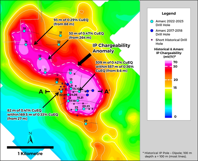
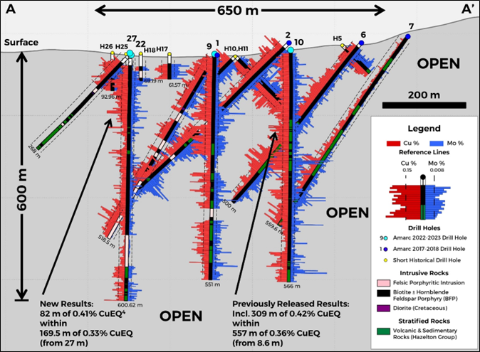
Amarc Resources (TSXV:AHR) has reported all assay findings from its groundbreaking Phase 1 core drilling program. The program took place at the DUKE porphyry Cu-Au district, located in central British Columbia, and is fully owned by the company.
Between the early days of December 2022 and mid-March 2023, Amarc successfully executed 24 core drill holes, summing up to an impressive 11,086 metres, within a meticulously planned 80-drill-day schedule. This extensive operation was carried out using two high-precision drill rigs dedicated to clarifying the geological nuances of the DUKE Cu-Mo-Ag-Au Deposit. Simultaneously, a third rig was put into action to investigate the overburden-rich, and strong 4.7 km2 Induced Polarization anomaly wrapping the DUKE Deposit. The anomaly suggests the presence of a comprehensive mineralized system.
An early snow melt in mid-May made way for teams to return on-site. Amarc has kept the momentum going with a recently concluded District-wide airborne magnetics survey. Concurrently, a multitude of ground geological, geophysics, and geochemical surveys are in progress with an expert team of over 35 technical and logistics crew members active on-site. These surveys will scrutinize 16 prioritized porphyry Cu-Au targets scattered across the DUKE District in preparation for the planned winter 2023-2024 drill testing.
As part of the 2023 agenda, Amarc has dedicated $10 million in exploration expenditures at the DUKE District. This exploration cost is covered in full under the Mineral Property Earn-in Agreement with Boliden Mineral Canada Ltd., also referred to as Boliden, as per the details released in the Amarc news release dated November 22, 2022. Amarc is maintaining full control over the project’s operation.
The Impact of DUKE Deposit Drilling Program
In the recently concluded Phase 1 drilling program, of the 24 holes drilled, 16 were widely-dispersed drill holes amassing 7,552 metres. These were completed to contribute to the understanding and delimitation of the DUKE Deposit. The explorative endeavours have not only amplified the extent of the DUKE Deposit porphyry Cu-Mo-Ag-Au system but have also bolstered Amarc’s grasp on the factors influencing mineralization within the DUKE District. The company has successfully crafted an exploration template to effectively sift and promote the additional 16 priority exploration targets within the expansive 678 km2 DUKE District tenure. This swift headway in understanding the mineralization control at the DUKE Deposit allows for an increased likelihood of success in the upcoming regional target areas.
In the DUKE Deposit, drill holes were placed on an approximate 200-metre grid, a strategic step-out from Amarc’s prior drilling. This effort validated that the DUKE Deposit extends to a depth of a minimum 600 metres and widened the deposit footprint laterally to over 650 metres north-south and 800 metres east-west. Additionally, detailed geological interpretation and modelling suggest a solid potential for further lateral expansion of the deposit, specifically to the east. One key characteristic of the porphyry Cu-Mo-Ag-Au mineralization in these extensive holes is the existence of zones of higher-grade mineralization enclosed within broader envelopes of comparatively average grade. Notably, with further drilling, significant potential arises for defining internal higher-grade zones.
The DUKE Deposit comprises a sequence of Babine porphyry intrusions positioned within volcanic and sedimentary rocks. These junction zones are marked by heightened Cu-Mo grades, often spanning tens of metres in width, within both the intrusions and the neighbouring volcanic and sedimentary rocks. This significant Cu-Mo mineralization extension from the intrusions into the surrounding volcanic and sedimentary rocks extensively augments the DUKE Deposit volume potential.
Testing of the Broad Mineralized System Encasing the DUKE Deposit
Aside from the work at the DUKE Deposit, Amarc also successfully completed eight Phase 1 core holes, aggregating 3,534 metres, within the robust mineralized system demarcated by a 4.7 km2 IP chargeability anomaly. These distributed drill holes (300 to 500 metres apart) scrutinized a range of geophysical and geological targets. Notably, drill hole DK23012, situated 500 metres northwest of the DUKE Deposit, returned an important 30-metre intercept of 0.47% CuEQ, providing an essential target for subsequent drilling. Amarc’s ongoing data interpretation and modelling efforts are oriented towards vectoring outward from the DUKE Deposit to this target, and other zones of mineralization nestled within the broader mineralized system.
Exploration Program in the DUKE District
Amarc has just wrapped up an expansive 5,759 line-kilometre, helicopter-assisted high-resolution aeromagnetic survey, covering an area surpassing 500 km2 over the DUKE District. The results from this survey, which expand on previous Amarc and historical aeromagnetic coverage, are being integrated into the comprehensive District-wide exploration program. The mission of this program is to clearly define multiple porphyry Cu-Au deposit drill targets.
A broad surface exploration program has also been initiated, complete with a logistics team, and a trio each of geological mapping, geophysical and geochemical sampling crews, already working on-site. The aim of these surveys is to establish well-defined drill targets for the winter 2023-2024 drilling. Initially, 16 prospective deposit target areas have been chosen based on a comprehensive compilation of government and historical data encompassing the entire District. The compilation underscores the surprisingly low exploration maturity of the productive Babine porphyry Cu-Au region and offers a new interpretation of its geological, geochemical and geophysical characteristics. Furthermore, Amarc’s 2022-2023 drilling at the DUKE Deposit has yielded valuable insights about porphyry deposit exploration footprints in the region.
Highlights from the results are as follows:
- 183 m of 0.43% CuEQ* (0.31% Cu, 0.019% Mo, 0.07 g/t Au,1.5 g/t Ag) in hole DK22009**
- 217 m of 0.45% CuEQ (0.33% Cu, 0.018% Mo, 0.08 g/t Au, 1.5 g/t Ag) in hole DK22010**
- 30 m of 0.47% CuEQ (0.36 % Cu, 0.015% Mo, 0.06 g/t Au, 3.2 g/t Ag) in hole DK23012
- 30 m of 0.43% CuEQ (0.31% Cu, 0.014% Mo, 0.09 g/t Au, 1.6 g/t Ag), and
33 m of 0.44% CuEQ (0.20% Cu, 0.053% Mo, 0.06 g/t Au, 1.3 g/t Ag) in hole DK23015 - 82 m of 0.41% CuEQ (0.30% Cu, 0.017% Mo, 0.06 g/t Au, 1.1 g/t Ag) in hole DK23022
- 36 m of 0.47% CuEQ (0.34% Cu, 0.024% Mo, 0.06 g/t Au, 1.5 g/t Ag) in hole DK23024
- 33 m of 0.40% CuEQ (0.30% Cu, 0.017% Mo, 0.05 g/t Au, 1.5 g/t Ag) in hole DK23026
* Copper equivalent (CuEQ) calculations use metal prices of: Cu US$4.00/lb, Mo US$15.00/lb, Au US$1,800.00/oz and Ag US$24.00/oz and conceptual recoveries of: Cu 85%, Mo 82%, Au 72% and 67% Ag.
** Holes DK22009 and DK22010 were previously reported in Amarc releases dated January 26, 2023 and February 15, 2023, respectively
The above references an opinion and is for information purposes only. It is not intended to be investment advice. Seek a licensed professional for investment advice. The author is not an insider or shareholder of any of the companies mentioned above.
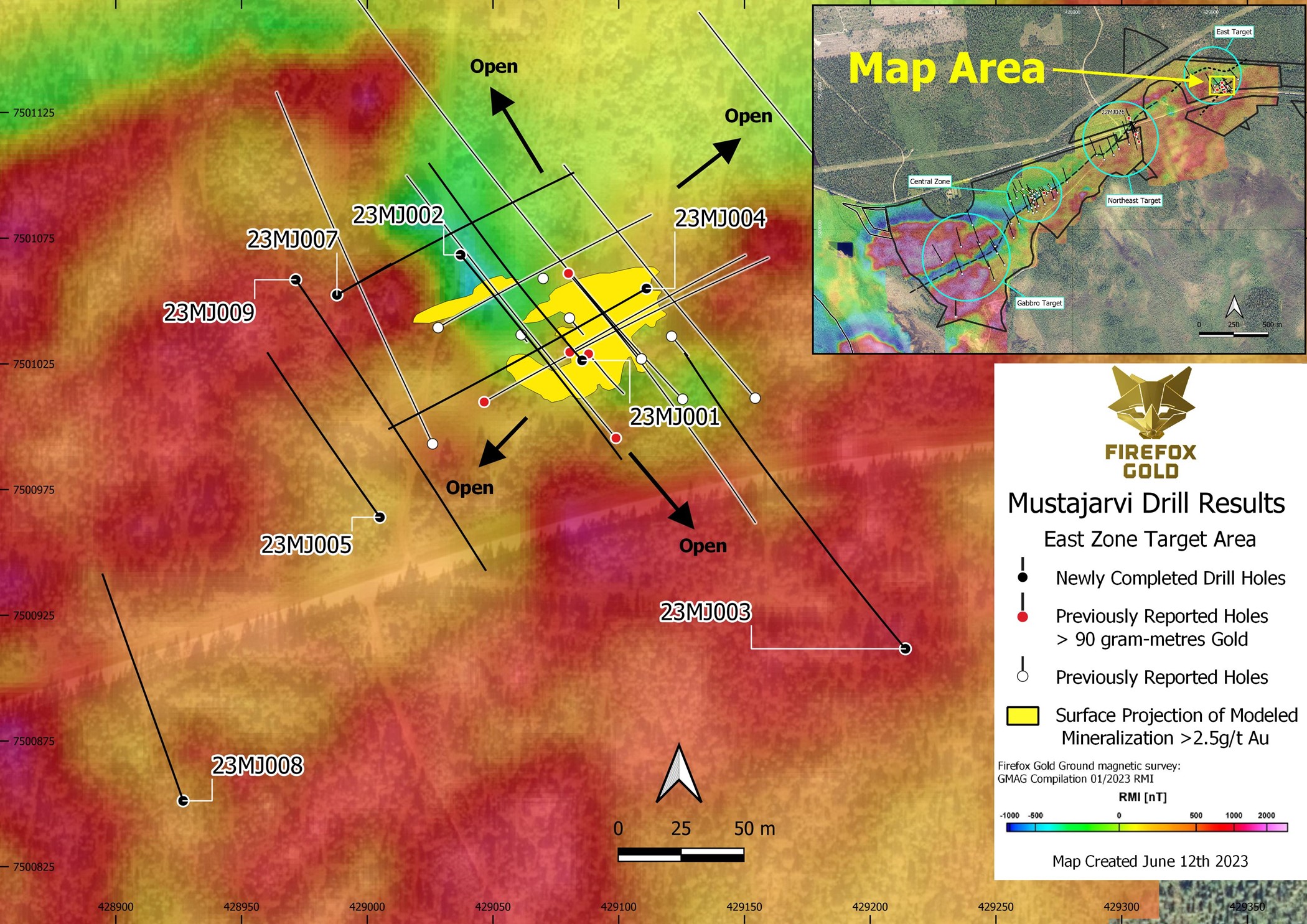
FireFox Gold Corp. (TSXV:FFOX) (OTCQB:FFOXF) has announced the successful completion of a drilling program at the newly identified high-grade zone in the East Target of the Mustajärvi Project. This spring 2023 project saw the company drilling nine diamond core holes with a cumulative length of 1540.6 metres. These drillings aimed to fill gaps in the modelled near-surface gold shapes and explore possible extensions to the west and southwest.
The program also included drilling at key points in the replacement style gold mineralization found in the East Target, with step-outs of 80m and 220m along the southwest strike. The company is currently analyzing assays of the drill core.
FireFox Gold has also completed a multielement geochemical analysis of the drill core obtained from the 2022 fall drilling campaign. This new data aligns with the earlier drilling results from Mustajärvi; the gold mineralization has consistently high levels of bismuth (Bi), tellurium (Te), molybdenum (Mo), selenium (Se), nickel (Ni), and cobalt (Co). Silver (Ag), arsenic (As), and copper (Cu) were found at relatively low levels at Mustajärvi. Notably, Cobalt was found at high levels in the East Target, reaching maximum values of 0.497% and 0.461% over separate 1 metre samples in the 2022 drilling.
Located between Kittilä and Sodankylä and approximately 17 kilometres east of Kittilä, the Mustajärvi Project stretches across the Mustajärvi Shear Zone (MSZ). The Sodankylä Group rocks primarily in the northern part of the shear zone include metamorphosed sedimentary and volcaniclastic rocks. Three significant areas of gold mineralization have been identified along a 2.1-kilometer segment of the MSZ, namely the Central Zone, the Northeast Target, and the East Target.
The spring 2023 drilling was focused on the East Target with the main objective to extend known, shallow high-grade mineralization. The high chargeability zone strikes northeast and dips to the southeast, and it was untested until this drill program. Most of the drill holes in this program were shallow due to the near-surface nature of the high-grade target in this area.
FireFox Gold geologists are currently examining the new drill core, with samples still being delivered to the lab for further analysis. More updates are expected to be released in the coming weeks.
FireFox’s CEO, Carl Löfberg, commented in a press release: “This drill program is meant to reveal the potential scale of the gold system we have been drilling at Mustajärvi. The combination of careful structural measurements and detailed interpretation of geophysics directed the team to focus the step-out drilling along a northeast-southwest corridor. Our preliminary impressions are that the new drilling has been successful in extending the mineralized corridor to the southwest. The elevated cobalt that is associated with the gold is a recurring theme at Mustajärvi. While we know the cobalt occurs in pyrite, which is also correlated with the gold, there remains a lot of work to understand whether the cobalt could be economically recovered. We look forward to the receipt of the gold and multielement assays from this latest round of drilling.”
Table 1. Mustajärvi Spring 2023 Collar Information (coordinates presented in EPSG:3067).
| Drill Hole | Easting | Northing | Azimuth (°) | Plunge (°) | Final Depth (m) |
| 23MJ001 | 429085 | 7501026.4 | 320 | 60 | 188 |
| 23MJ002 | 429037 | 7501068.4 | 140 | 50 | 151.7 |
| 23MJ003 | 429214 | 7500911.7 | 320 | 60 | 284 |
| 23MJ004 | 429111 | 7501055 | 240 | 50 | 175.4 |
| 23MJ005 | 429005 | 7500964 | 325 | 60 | 152.1 |
| 23MJ006 | 428990 | 7501053.5 | 60 | 50 | 32.1 (failed) |
| 23MJ007 | 428988 | 7501052.4 | 60 | 50 | 168.9 |
| 23MJ008 | 428927 | 7500851.2 | 340 | 60 | 194.4 |
| 23MJ009 | 428972 | 7501058.5 | 145 | 45 | 194 |
The above references an opinion and is for information purposes only. It is not intended to be investment advice. Seek a licensed professional for investment advice. The author is not an insider or shareholder of any of the companies mentioned above.
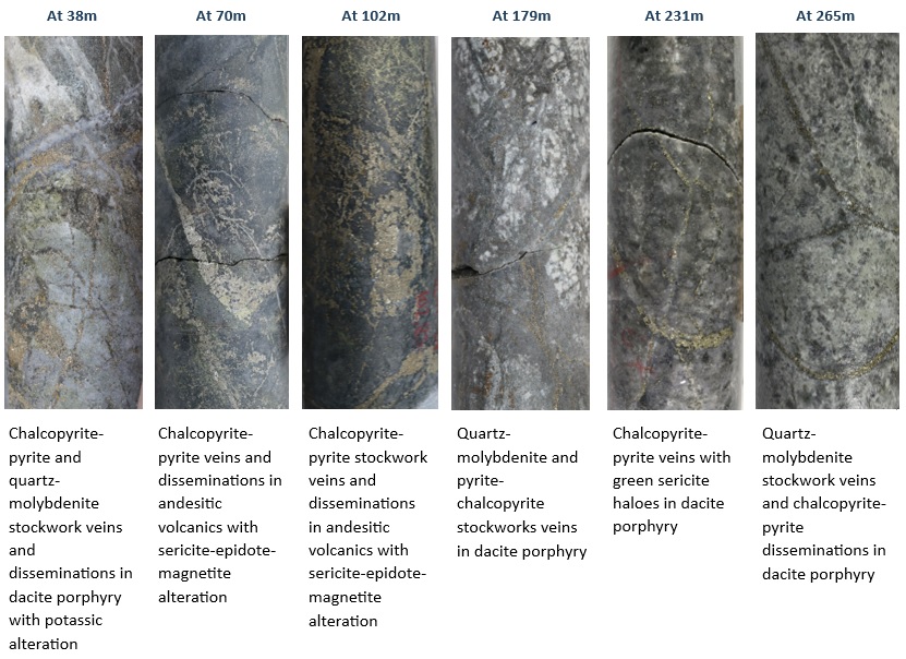
Solaris Resources Inc. (TSX:SLS) (OTCQB:SLSSF) has reported the discovery of a substantial new porphyry deposit. This new find, the sixth major discovery at the Warintza Project in the southeastern region of Ecuador, is located at the Patrimonio target, to the southwest of Warintza Central.
This news comes as part of a reconnaissance mapping and sampling initiative that the Company has been undertaking in an area to the southwest of Warintza Central. Notably, the preliminary drill hole in this target has been concluded, yielding impressive results. The visual examination of SLSP-01 verified the unearthing of a significant new porphyry deposit that is rich with high concentrations of valuable minerals such as chalcopyrite, molybdenite, and pyrite.
The Patrimonio target was initially identified during the Company’s comprehensive mapping and sampling program, the details of which were released in a press release dated April 11, 2023. It’s important to note that this new porphyry deposit extends from the surface down to the end of the drill hole, providing an exciting opportunity for potential mineral extraction and economic development.
Solaris’s discovery signals a promising prospect for the company and underscores the rich mineral potential of the Warintza Project, a characteristic that continues to be unveiled as further exploration and drilling activities are undertaken.
Mr. Jorge Fierro, Vice President, Exploration, commented in a press release: “Patrimonio is an exciting, new discovery, unique in terms of the intensity of mineralization and alteration within the Warintza porphyry cluster. Together with the recent discovery of a second and higher-grade porphyry center to the south of Warintza East we now distinguish as Warintza Southeast, the Patrimonio discovery provides strong validation of our exploration approach of systematic soil sampling led by senior geologist, Keller Guerra, that has also identified areas of significantly stronger soil anomalism in the Warintza West and Warintza South areas for future exploration.”
Highlights from the results are as follows:
- Patrimonio represents the sixth major discovery within the Warintza porphyry cluster, after the original Warintza Central deposit discovered by the late David Lowell in 2000, and Solaris discoveries at Warintza West (February 2021), Warintza East (July 2021), Warintza South (January 2022), most recently Warintza Southeast (May 2023) and now Patrimonio
- Patrimonio is defined by an elongated north-south molybdenum anomaly measuring 1.5km x 0.5km enveloped by a copper anomaly extending west, with outcropping porphyry displaying pervasive potassic alteration and stockwork veining, located on the western side of an interpreted major north-south fault adjacent to Warintza Central
- SLSP-01 is the first reconnaissance hole to test the Patrimonio target and was drilled northwest to the maximum depth capacity of the KD-200 rig. The hole intersected stockwork veining and disseminated sulphide mineralization in intrusive and volcanic rocks from surface to the end of hole at 310m where the zone remains open
- Sulphide minerals at Patrimonio include pyrite, chalcopyrite and molybdenite with total sulphide abundances up to 10%, as much as two-times higher than previously logged at Warintza Central
- First assays from SLSP-01 are expected within four to six weeks. Follow-up drill holes SLSP-02, drilled southwest from the same platform, and SLSP-03, a northeast step-out testing the potential contact area between Patrimonio and Warintza Central, are already underway
- Preliminary interpretation places SLSP-01 in the high-temperature core of a sulphide-rich copper porphyry at Patrimonio, with follow-up drilling underway expected to aid in defining the architecture of the system and its relationship to Warintza Central
- The reader should be cautioned that only assay results from a laboratory can confirm whether concentrations of metals are present and, as such, visual core characterization presented herein should be viewed as speculative in nature
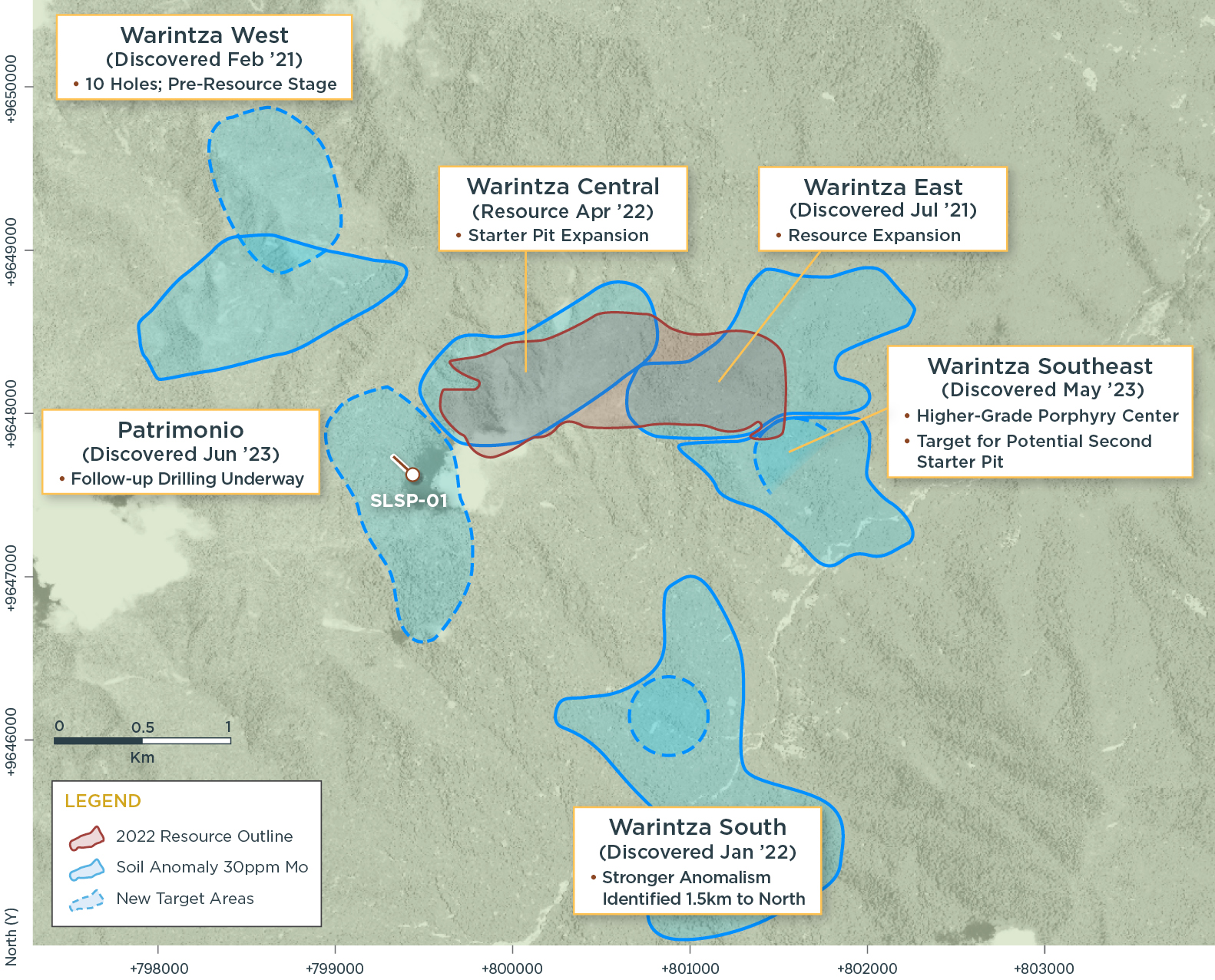
Table 1 – Collar Location
| Hole ID | Easting | Northing | Elevation (m) |
Depth (m) |
Azimuth (degrees) |
Dip (degrees) |
| SLSP-01 | 799430 | 9647634 | 1519 | 310 | 315 | -60 |
| Notes to table: The coordinates are in WGS84 17S Datum. | ||||||
The above references an opinion and is for information purposes only. It is not intended to be investment advice. Seek a licensed professional for investment advice. The author is not an insider or shareholder of any of the companies mentioned above.
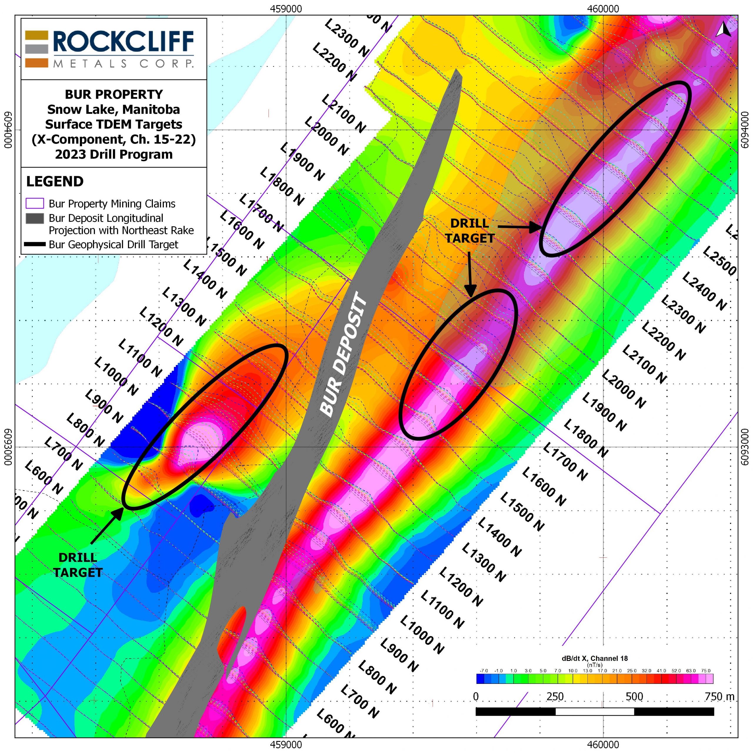
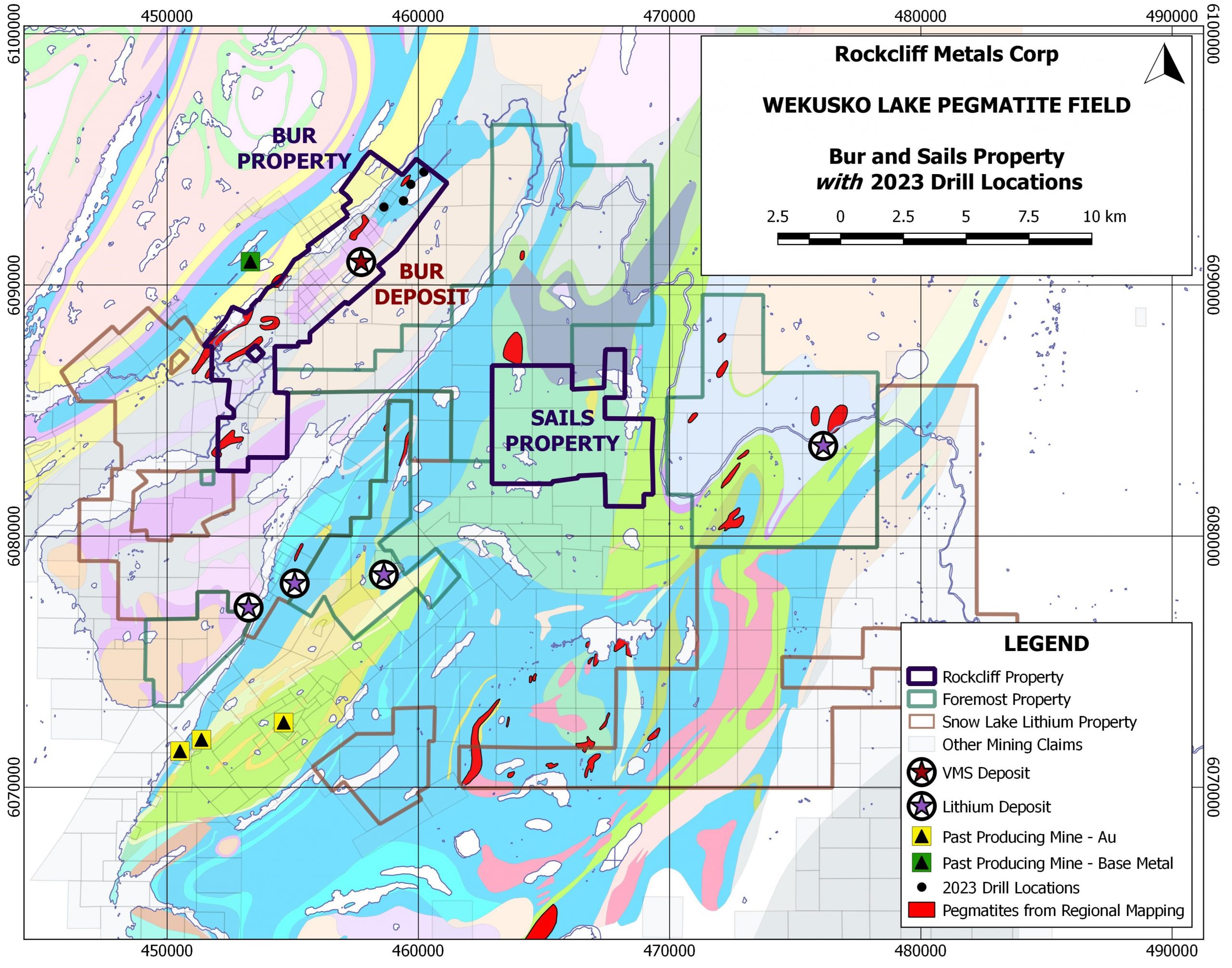
Rockcliff Metals Corporation (CSE: RCLF) has completed its focused winter drilling operations at the Bur Property. The strategic location of this property, being roughly 30 kilometres from the heart of the Snow Lake Mining Camp by gravel and paved road, makes it an advantageous area of operation.
The Snow Lake Project comprises four major deposits teeming with copper-zinc-gold-silver (Bur, Talbot, Tower, and Rail) and various budding prospects, each centered around Snow Lake. Integrated within the globally significant Flin Flon-Snow Lake Greenstone Belt (“The Belt”), this project resides in the world’s largest Paleoproterozoic volcanogenic massive sulphide (“VMS”) district and one of the most prolific VMS domains.
Deep Dive into the Winter Drill Program at the 100% Owned Bur Property VMS
With an intense focus on identifying geophysical VMS targets, Rockcliff Metals Corporation completed 1,379 metres of drilling in four separate drills. Each drill tested distinct geophysical conductive targets in close vicinity to the strategically significant Bur VMS (copper-zinc) Deposit (Refer to Figure 1). This deposit, solely owned by Rockcliff, is a rich resource of copper and zinc that continues to offer potential as it remains open at depth and along strike.
All identified targets intersected and were validated by fine-grained to massive pyrite sulphides found within graphitic fault breccia. Despite these promising discoveries, the four drills completed did not intersect any substantial copper-zinc mineralization. Despite this, with its prime location and extensive resources, the Bur Property continues to hold strategic value for Rockcliff Metals Corporation.
| Classification | Tonnes (k) |
Cu (%) |
Zn (%) |
Au (g/t) |
Ag (g/t) |
CuEq (%) |
Cu (Mlbs) |
Zn (Mlbs) |
Au (koz) |
Ag (koz) |
CuEq (Mlbs) |
| Measured | 338 | 1.54 | 3.58 | 0.05 | 12.94 | 2.87 | 11.48 | 26.68 | 0.54 | 140.62 | 21.39 |
| Indicated | 2,679 | 1.70 | 6.45 | 0.02 | 3.41 | 3.97 | 100.41 | 380.95 | 1.72 | 293.71 | 234.48 |
| Measured/Indicated | 3,017 | 1.69 | 6.13 | 0.02 | 4.48 | 3.84 | 112.37 | 407.59 | 1.94 | 434.41 | 255.33 |
| Inferred | 2.342 | 1.03 | 8.65 | 0.00 | 0.91 | 4.04 | 53.18 | 446.62 | 0.00 | 68.52 | 208.59 |
- CIM definitions are followed for classification of Mineral Resource.
- Mineral resources are contained within a mineralized vein (zone) dipping at approximately 60 degrees towards the northwest whose closest vertical depth from surface is 6 m and maximum vertical depth is 1,274 m.
- Resources are constrained to a minimum true vein thickness of 0.2 m and where calculated block revenues after recovery are greater than costs for mining.
- CuEq (%) = Cu (%) + Zn (%) x 0.347 + Au(gpt) x 0.430 +Ag(gpt) x 0.005
- ZnEq (%) = Cu (%) x 2.885 + Zn (%) + Au(gpt) x 1.241 + Ag(gpt) x 0.016
- CuEq and ZnEq formulas are calculated using the following revenue inputs: Cu US$ 3.26/lb, Zn US$ 1.13/lb, Au US$ 1,744/oz, and Ag US$ 22.05/oz. Metal recoveries are: 80% Cu, 80% Zn, 40% Au and 40% Ag.
- Mining costs used to determine prospects for eventual economic extraction total C$110/t.
- US$ to C$ exchange rate applied is 1:1.31.
- Specific gravity for the mineralized zone is fixed at 3.1.
- Totals may not represent the sum of the parts due to rounding.
- The Mineral Resource estimate has been prepared by Derek Loveday, P. Geo. of Stantec Consulting Services Ltd. in conformity with CIM “Estimation of Mineral Resource and Mineral Reserves Best Practices” guidelines and are reported in accordance with the Canadian Securities Administrators NI 43-101. Mineral resources are not mineral reserves and do not have demonstrated economic viability. There is no certainty that any mineral resource will be converted into mineral reserve.
- The 100% owned Bur Property is part of the Company’s extensive Manitoba property portfolio, has excellent infrastructure with a year-round access road, clearing for portable buildings, and a box cut and portal. The Bur Property lies within the Flin Flon-Snow Lake greenstone belt, the largest Paleoproterozoic VMS district in the world and the most prolific VMS district in Canada.
The above references an opinion and is for information purposes only. It is not intended to be investment advice. Seek a licensed professional for investment advice. The author is not an insider or shareholder of any of the companies mentioned above.
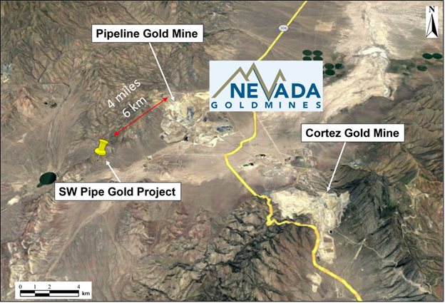
NV Gold Corporation (TSXV:NVX) has shared an encouraging exploration update. The update is about their wholly-owned SW Pipe Gold Project (“SW Pipe”), nestled in Lander County, situated about 6 km or 3.7 miles southwest of the prolific Pipeline Gold Mine in the heart of the Cortez gold belt in north-central Nevada.
Thomas Klein, VP Exploration, commented in a press release: “I am excited by the outcome of this new technical update (“Exploration Target”) and the potential ounces modeled by Mr. Jesse D. Wellman. NV Gold has successfully delineated a substantial near surface, oxide gold system at its SW Pipe property in Lander County, Nevada. This area of gold mineralization can be interpreted as possible “leakage” from a larger target at depth, emplaced through structural conduits. Given the favorable setting proximal to several large gold deposits, the modest deposit is further support for deeper exploration.”
The exploration update projected an exploration target containing between 35,000 and 70,000 oxide ounces of gold. This treasure is buried within the SW Pipe project, which enjoys a geographical advantage of proximity to the Pipeline/Gold Acres/Robertson Battle Mountain-Cortez Trend complex.
In the SW Pipe project, surface oxide gold mineralization is harbored within diverse rock types like sandstone, chert, shaly siltstone, greenstone, and slate. These rock formations are believed to be a part of the western facies linked with the Roberts Mountain Thrust.
The SW Pipe project boasts a rich exploration history with at least 7 distinct drilling programs conducted. These efforts have generated 49 reverse circulation drill holes, which now serve as valuable data for modeling. While the drill holes data do not provide enough density to calculate an Inferred Resource, it does offer an exploration target that includes between 5 and 6 million tons. The grade of this resource varies from 0.25 to 0.40 g/t. This target was meticulously developed using 2d sections placed 70 meters apart, considering the mean grade of each intercept, with a variance of +/- 25 percent. Notably, density values lie between 2.45 g/cm3 and 2.55 g/cm3.
The SW Pipe exploration target features 26 mineralized zones, each extending at least 3 meters downhole. It stretches at least 1.3km in a northwest-southeast trend and has a breadth of 0.6km.
The most recent update from NV Gold, dated May 10, 2023, reported the commencement of drilling at the SW Pipe site. However, the works faced rough terrains, leading to the termination of the initial hole in favor of resource conservation. The company swiftly responded to the situation by repositioning the drill rig to its promising Triple T Gold Project.
The above references an opinion and is for information purposes only. It is not intended to be investment advice. Seek a licensed professional for investment advice. The author is not an insider or shareholder of any of the companies mentioned above.

The first half of 2023 has been a whirlwind of activity for the management of Brazil Potash, and on June 5, 2023, the company provided a shareholder update. Notably, their efforts have garnered robust support from Brazil’s newly established federal government and considerable interest in the remaining potash offtake rights. The momentum was underscored by a keynote panel speech delivered at the International Fertilizer Association (IFA) annual conference.
The conference, attended by a crowd of over 1,500, included the top executives of major fertilizer companies worldwide. Among the distinguished participants was Matt Simpson, Brazil Potash’s CEO. His keynote address emphasized the significance of “building sustainable supply chains to ensure food security,” with particular emphasis on the concept of “selective globalization.” This suggests that domestic production of certain essential goods should be prioritized to guarantee supply availability.
Simpson’s remarks bear particular relevance to Brazil, a country recognized as one of the globe’s most prolific agricultural exporters, with an output exceeding US$110 billion per annum. Given its vast freshwater resources, fertile land, and a climate suited for year-round crop cultivation, Brazil’s role in global food security is set to expand in tandem with global population growth. However, it faces a vulnerability in importing over ~98% of its potash needs, primarily from Canada, Russia and Belarus, despite housing one of the world’s largest basins.
This message has resonated with Brazilian governmental bodies, as evidenced by recent public declarations of support from influential figures like Vice President Geraldo Alckmin, Governor of Amazonas Wilson Lima, and Mayor of Autazes Andreson Cavalcante. Their backing has catalyzed the progression of the licensing process, leading to a ruling by the President of Brazil’s Federal court (TRF-1) to reinstate Brazil Potash’s Preliminary (Social and Environmental) License. This is considered a crucial forward stride toward obtaining the Installation License required to commence project construction.
Simultaneously, Brazil Potash has been engaging in discussions with several esteemed companies to secure long-term take or pay contracts for an additional 1.5 million tonnes, with an eye on equity investment. This is part of their strategy to assure banks providing debt financing of credible counterparties interested in purchasing their potash and agreeing on price terms. The remaining 200,000 tonnes of annual production is projected to be reserved for spot sales, ensuring production flexibility.
Brazil Potash has also prioritized its Environment, Social, and Governance (ESG) strategy, a testament to which is the completion of work that can be reviewed on the Company’s website. Morgan Stanley Capital International (MSCI), a respected third party, reviewed and rated the company’s policies and actions, awarding them an ‘A’ rating. This places Brazil Potash in the top quartile of their producing peers, underscoring their commitment to leadership in this domain.
In the quest to drive the project’s development, Brazil Potash has been meticulously working towards forming a robust board of directors with industry and thought leaders. More information on this will be shared in future shareholder updates.
Even as Brazil Potash celebrates the progress of key initiatives, its focus remains unwavering on obtaining licensing and strengthening its community presence. The company is committed to contributing significantly to global food security and, crucially, delivering robust shareholder returns.
The above references an opinion and is for information purposes only. It is not intended to be investment advice. Seek a licensed professional for investment advice. The author is not an insider or shareholder of any of the companies mentioned above.
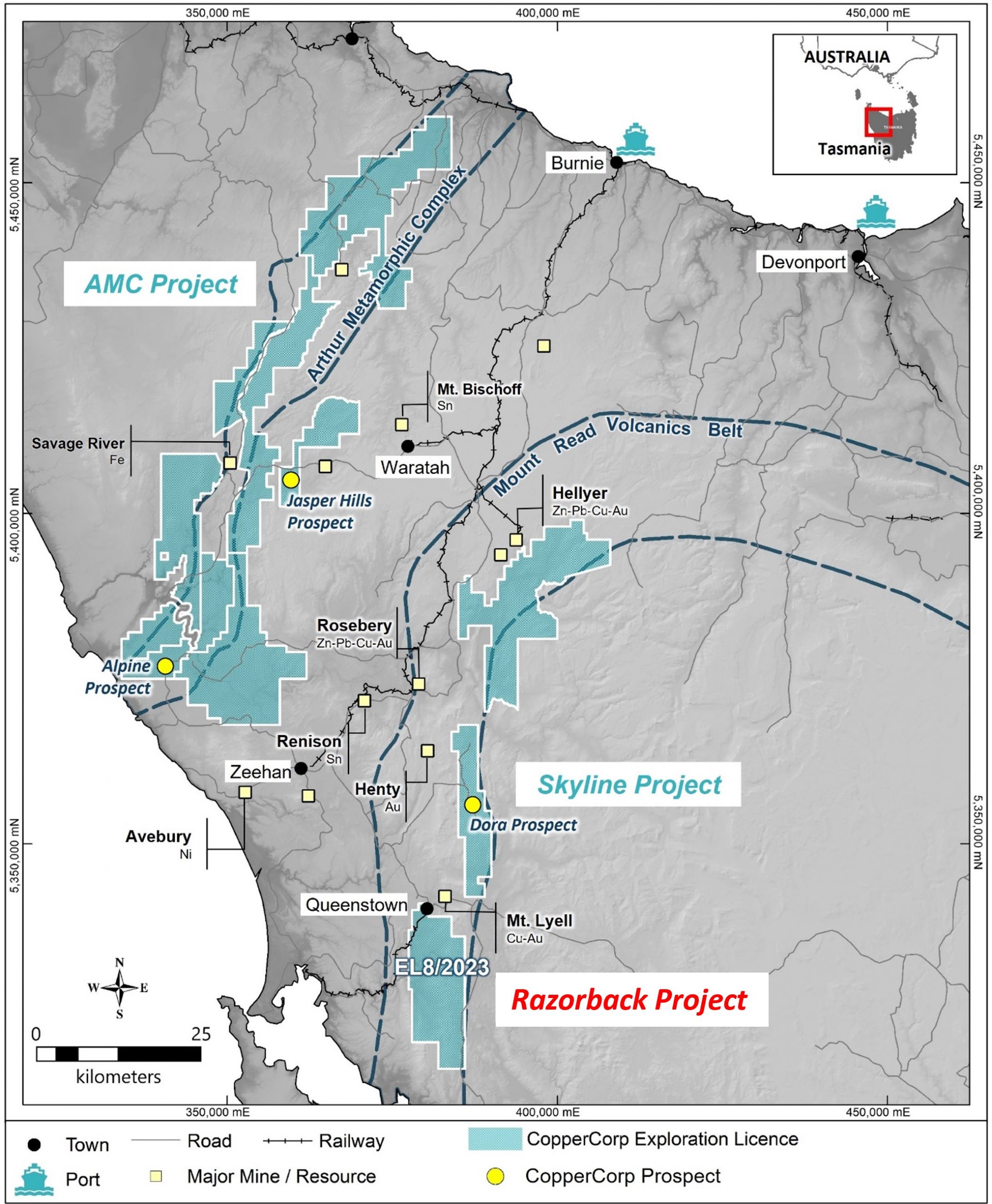
CopperCorp Resources (TSXV:CPER) (OTCQB:CPCPF) has announced that its wholly-owned division, Georgina Resource Pty Ltd, has acquired exploration license EL8/2023, known as the “Razorback Project.” The license was won through Tasmania’s Exploration Release Area (ERA) competitive bidding process and involves an area situated south of the notable Mt Lyell copper mine in the scenic expanse of western Tasmania, Australia.
Steve Swatton, President and CEO of CopperCorp commented in a press release: “The Razorback land package has been recognized and highly regarded by our team since inception of the Company. The project is located immediately south and along trend of the 3 million tonne (contained copper) historic Mt Lyell mine which has generated significant copper and gold since starting production in the late 1800’s and still has a reported 25-year mine life3. Previous exploration work completed at Razorback indicates the presence of significant copper, gold and rare earth mineralization including in surface sampling and drill intercepts. We look forward to initiating a work program to advance exploration at Razorback including following up on the significant copper-gold and rare earth surface showings and intercepts.”
Known for their diligent work and strategic approach, CopperCorp has identified promising prospects for unearthing primary rare earth elements (REE) and copper-gold deposits within the iron oxide of the Razorback Project locale. This optimism stems from earlier drilling results that produced substantial rare earth oxide (TREO) intercepts and Cu-Au intercepts. Additionally, areas revealing anomalous REE assays from surface rock chip sampling show potential for new REE exploration targets.
Adding to their exploration portfolio, the successful Razorback Project bid grants CopperCorp an additional 171 square kilometres of mineral license holdings, augmenting the firm’s current assets with the 100%-owned AMC and Skyline projects in western Tasmania. The total combined exploration license holdings now stand at 1,571 square kilometres.
The Razorback Project is ideally situated over the Middle Cambrian aged Mt Read Volcanics (MRV), immediately south of the Mt Lyell copper project. Its easy access via all-weather gravel roads and proximity to necessary infrastructure such as power transmission lines and regional mining centres make it an attractive prospect.
MRV, a curved belt of calc-alkaline volcanic sequences, hosts various world-class polymetallic base metal, Cu-Au, and Au-only deposits, all testament to the Tyennan Orogeny’s metallogenic prowess. CopperCorp holds strong potential for uncovering magmatic-hydrothermal related iron oxide copper-gold (IOCG) deposits and hybrid porphyry-epithermal Cu-Au/Au-only deposits in the Razorback Project.
The project’s background also reveals excellent potential for rare earth element (REE) mineralization. Historical exploration drilling results disclose REE intercepts and anomalous REEs in surface rock chip sampling, indicating the presence of valuable REE minerals, a prospect CopperCorp is eager to explore further.
The Razorback Project, with a history of intermittent exploration since the mid-1950s, has seen geological mapping, gridding, sediment, soil geochemistry, and adit sampling, amongst other exploration activities. CopperCorp is ready to compile and digitize these historical exploration data, charting their way forward in targeting more REE and Cu-Au exploration targets.
With the formal granting of the exploration license, CopperCorp is already charting out an exploration strategy for EL8/2023, eager to share updates as the project unfolds. This marks yet another milestone in CopperCorp’s quest for discovery and innovation in mineral exploration.
| Licence ID | Project | Target Commodity | Status | Total Area km2 |
| EL8/2023 | Razorback | Rare Earths-Copper-Gold | Priority Application | 171 |
Table 1. Summary of CopperCorp’s new licence application in western Tasmania, Australia.
| DH ID | From m |
To m |
Width m |
TREO % |
CeO2 % |
La2O3 % |
Nd2O3 % |
Pr6O11 % |
Sm2O3 ppm |
Gd2O3 ppm |
Dy2O3 ppm |
Eu2O3 ppm |
Er2O3 ppm |
Tb4O7 ppm |
Ho2O3 ppm |
Tm2O3 ppm |
Lu2O3 ppm |
Yb2O3 ppm |
Y2O3 ppm |
| SDD005 | 297 | 327 | 30 | 2.08 | 0.99 | 0.5 | 0.33 | 0.1 | 500 | 300 | 128 | 48 | 32 | 34 | 16 | 4 | 3 | 22 | 448 |
Table 2. Rare earth oxide values from significant drill hole intercept in SDD005 30.0M @ 2.1% TREO (1.0% TREO cut-off). Values have been rounded.
The above references an opinion and is for information purposes only. It is not intended to be investment advice. Seek a licensed professional for investment advice. The author is not an insider or shareholder of any of the companies mentioned above.
Aztec Minerals (TSXV:AZT), shared the assay results from three of its drill holes, part of the 2023 core drilling initiative at the historic Tombstone project in southeastern Arizona. Aztec, holding a significant 75% stake in the Tombstone Property Joint Venture, is involved in managing a majority of the region’s original patented mining claims, and more recently acquired properties.
Aztec Mineral CEO Simon Dyakowski commented in a press release: “Our first core drilling program at the Tombstone Project continues to intersect broad, shallow, and oxidized zones of high-grade silver and gold, at the Contention open pit target. These most recent results highlight the expansion of the mineralized zone in the south-central and eastern portion of the target zone. We eagerly await the receipt of assays from the final holes of the now complete core drilling program.”
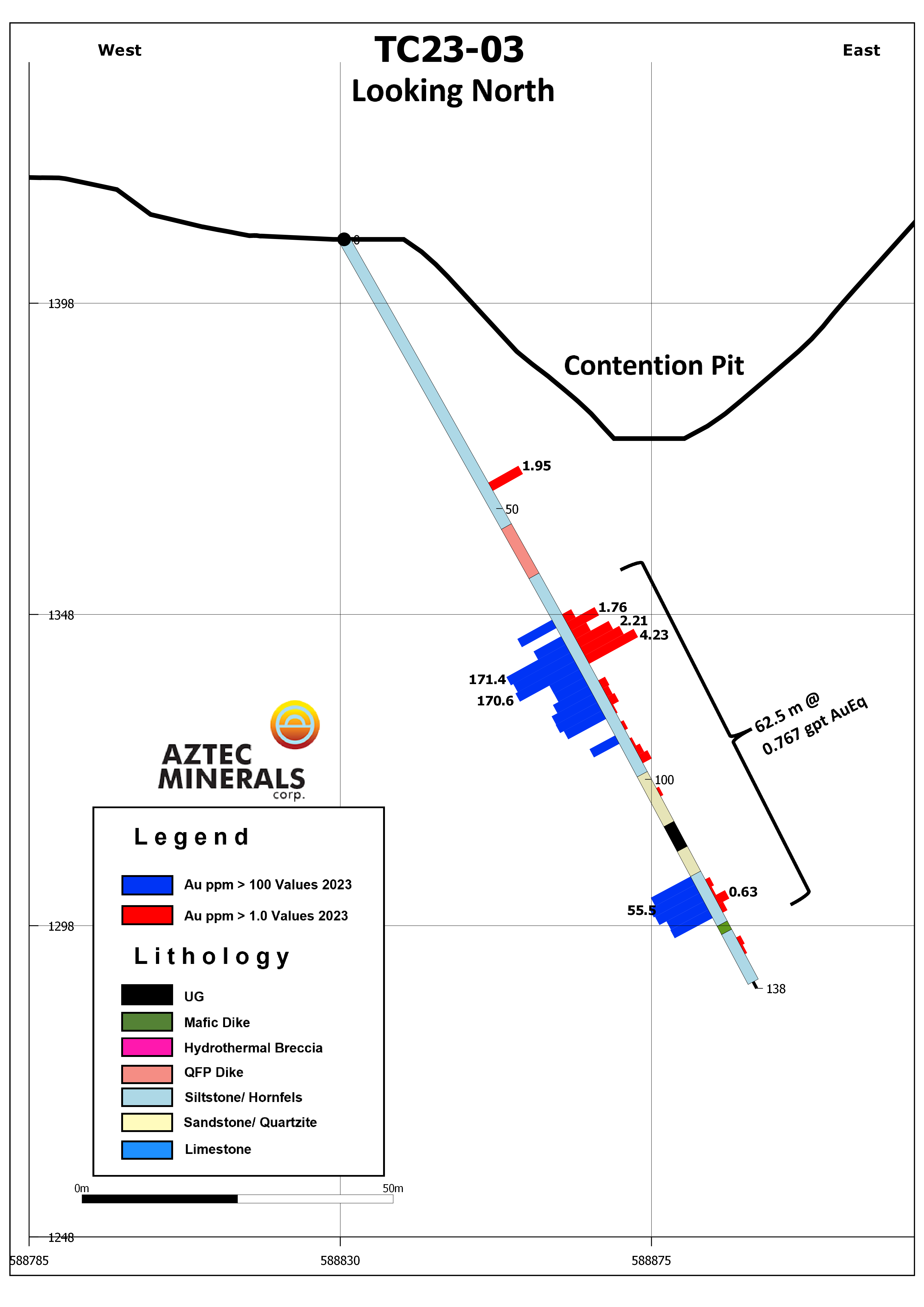
The three drill holes, forming a part of a 7-hole program, were meticulously drilled in a fan-grid pattern across the Contention open pit. All the drill holes made a significant impact, intersecting several underground mine workings.
The high-grade samples of silver and gold were found in the drill hole TC23-05, which was located within a zone of oxidized, altered siltstones and sandstones, and a Qfp dike at a relatively shallow depth between 19.8 and 55.8 meters. The drill hole TC23-05 unveiled a broad oxidized zone with an average of 2.82 gpt Au and 176.64 gpt Ag (5.02 gpt AuEq), with several high-grade silver zones also being discovered. It’s worth noting that the gold equivalence (AuEq) was determined using an 80:1 silver:gold ratio. The drill hole also encountered multiple levels of mine workings, suggesting the Blue limestone target was reached with a mineralized zone near the end of the drill hole.
Further, the drill hole TC23-03, situated within the central portion of the main Contention pit, yielded 62.5 m of 0.47 gpt Au and 24.05 gpt Ag (0.77 gpt AuEq) in oxidized, altered siltstones and sandstones, and a Qfp dike with mine workings.
Drill hole TC23-04, located near the east foot of the Contention pit, intersected 35.0 m of 0.12 gpt Au and 19.14 gpt Ag (0.36 gpt AuEq) in oxidized, altered siltstones and sandstones, and a Qfp dike with multiple mine workings.
In addition, drill hole TC23-02, initially drilled to a depth of 27 m, was temporarily suspended due to challenging drilling conditions but was later resumed and successfully extended to a total depth of 139 m. The results from the samples taken from this hole are eagerly awaited within the next three weeks, alongside the results from holes TC23-06 and TC23-07.
These three drill holes – TC23-03, TC23-04, and TC23-05 – were aimed at expanding the mineralization knowledge in the central and southern portions of the main Contention pit. The entire drilling program was meticulously planned to navigate through the complex old mine workings, multiple faults, and reach the water table just below the sixth level and the key district host limestones at depth. The drilling has successfully widened the extent of mineralization to the west, east, and to depth, indicating a potential increase in the volume of oxidized Au-Ag mineralization.
Aztec Minerals Corp. has now successfully completed its 7-hole core drilling program. Thus far, assays for four holes have been reported. The collection of samples adheres to a QAQC program that aligns with industry standards, including certified standards, blanks, and sample duplicates. The samples are regularly shipped to the Bureau Veritas Minerals laboratory in Hermosillo, Mexico for geochemical analysis.
The core samples are cut and consistently collected over 5 foot (1.52m) sample intervals from all drill holes. They were analyzed for gold using the fire assay method FA430, followed by multi-element MA300, which includes silver. When upper limits are reached, further analysis is conducted using either MA370 or FA530. As part of the quality control program, all holes contain certified blanks, standards, and duplicates. This comprehensive approach ensures the highest degree of accuracy and reliability in the company’s findings.
Highlights from the results are as follows:
- Assay results for additional 3 holes of the core drilling program reported herein
- Hole 23-05 intersected multiple high-grade silver-gold zones within a broad, oxidized, 36.0 m mineralized zone of 5.02 gpt AuEq, including 1.52 m of 1694 gpt Ag (54.5 oz/t Ag) and 1.52 m of 1470 gpt Ag (47.3 oz/t Ag) with 1.52 m of 53.5 gpt Au
- The core drilling program demonstrates presence of high-grade mineralization in the southern portion of the main Contention pit
- TC23-03, TC23-04, and TC23-05 expanded mineralization around the Contention pit to the east and at depth, confirmed gold and silver mineralization in historic workings near the sixth level
- The 7-hole core drilling program is now complete, with assay results pending from targets drilled in the South Contention pit and the northern end of the Contention pit
Table 1: Significant Drill Hole Intercepts
| Drill Hole | From m | To m | Interval m* | Au gpt | Ag gpt | Au Eq gpt (1) | Comments |
| TC23-01 | 53.3 | 178.3 | 125.0 | 0.58 | 72.19 | 1.63 | Incl. stopes of 15.9 m** |
| Including: | 61.0 | 62.5 | 1.52 | 22.40 | 48.70 | 23.01 | |
| 125.0 | 132.6 | 7.65 | 0.52 | 733.92 | 9.70 | ||
| Incl: | 126.5 | 128.0 | 1.52 | 0.12 | 3477.00 | 43.58 | |
| TC23-03 | 70.1 | 132.6 | 62.5 | 0.47 | 24.05 | 0.77 | Incl. stopes of 6.1 m** |
| TC23-04 | 12.2 | 47.2 | 35.0 | 0.12 | 19.14 | 0.36 | Incl. stopes of 2.9 m** |
| TC23-05 | 19.8 | 55.8 | 36.0 | 2.82 | 176.64 | 5.02 | Incl. stopes of 4.4 m** |
| including | 23.5 | 39.0 | 15.5 | 6.45 | 408.47 | 11.55 |
- AuEq is calculated using a 80:1 silver:gold ratio
* All interval widths are not true widths and intercept true widths are not yet estimated.
** The mine workings void values are treated as an average grade of the combination of samples immediately before and after the voids over the reported void widths, subject to top caps of 1 gpt Au and 100 gpt Ag when needed.
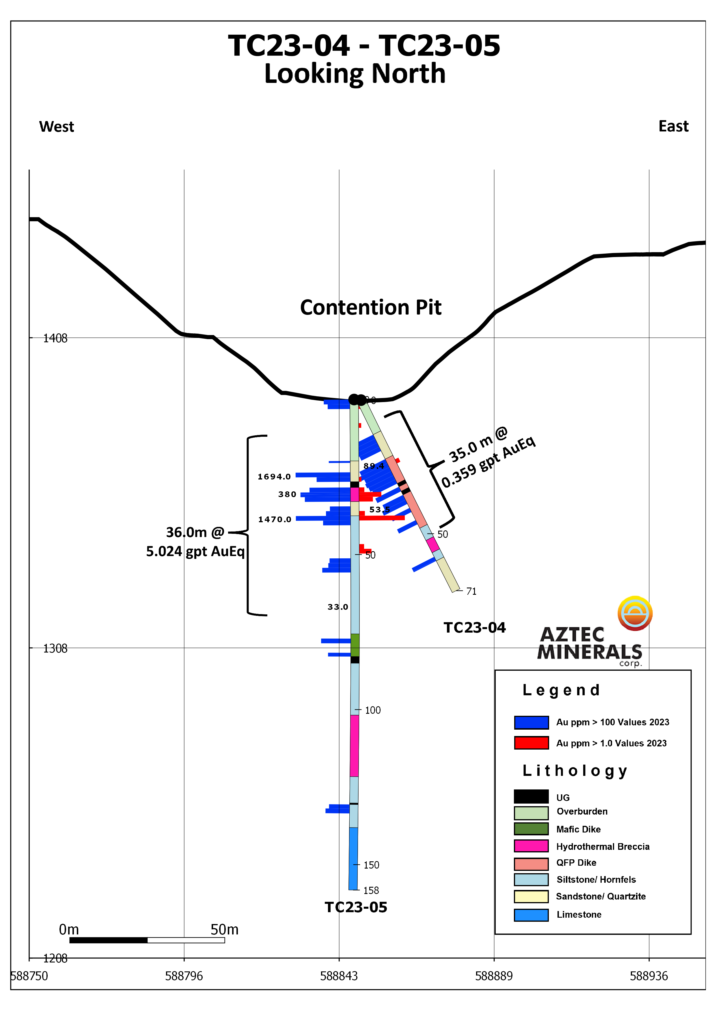
Table 2: Completed Drillhole Details (WGS84, Zone 12R)
| Drill Hole | Easting | Northing | Elevation | Azimuth | Dip | Depth |
| TC23-01 | 588804 | 350964 | 1414 m | 0 | -90 | 242.99 m |
| TC23-03 | 588832 | 3507837 | 1408 m | 103 | -60 | 138.37 m |
| TC23-04 | 588848 | 3507708 | 1387.7 m | 103 | -60 | 71.32 m |
| TC23-05 | 588846 | 3507707 | 1387.7 m | 0 | -90 | 158.19 m |
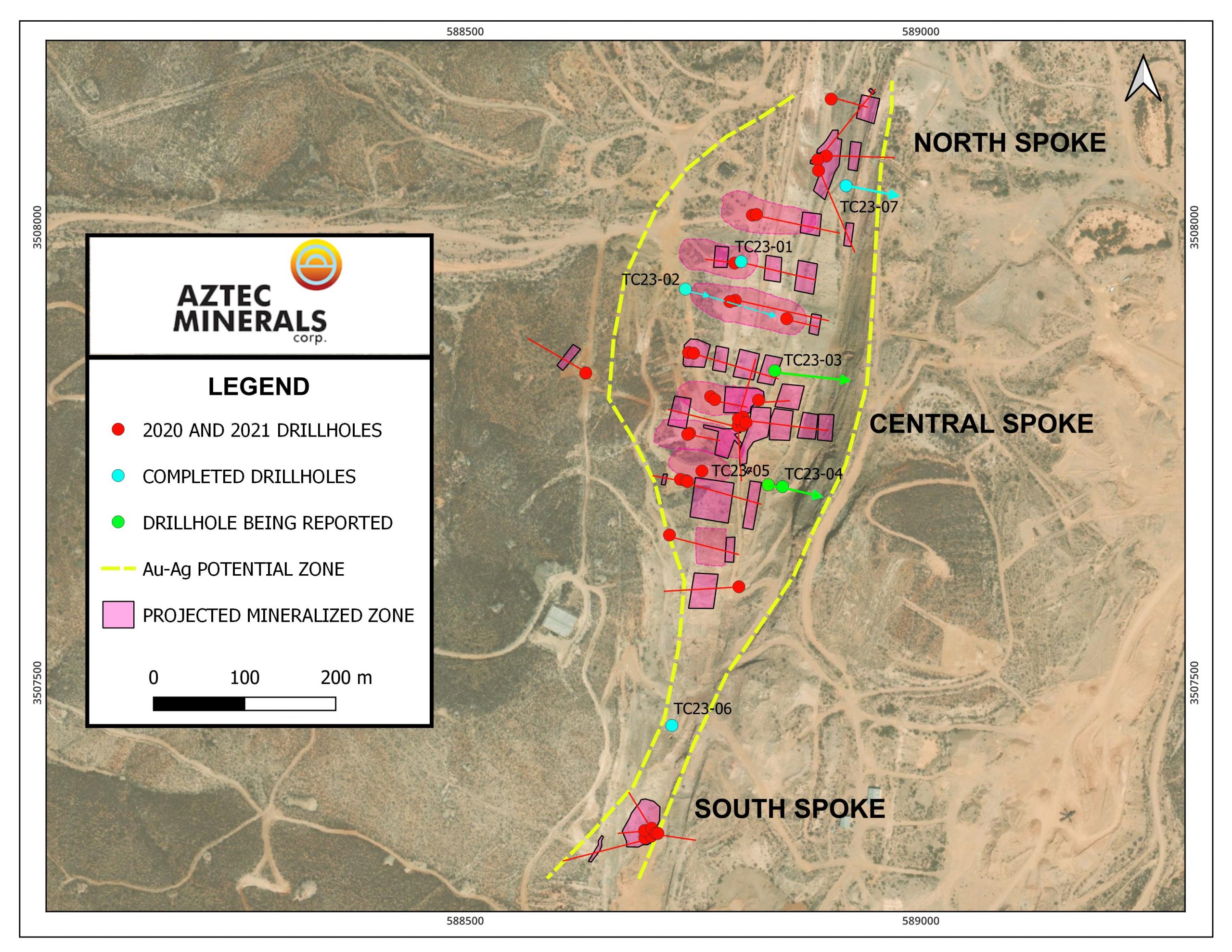
The above references an opinion and is for information purposes only. It is not intended to be investment advice. Seek a licensed professional for investment advice. The author is not an insider or shareholder of any of the companies mentioned above.
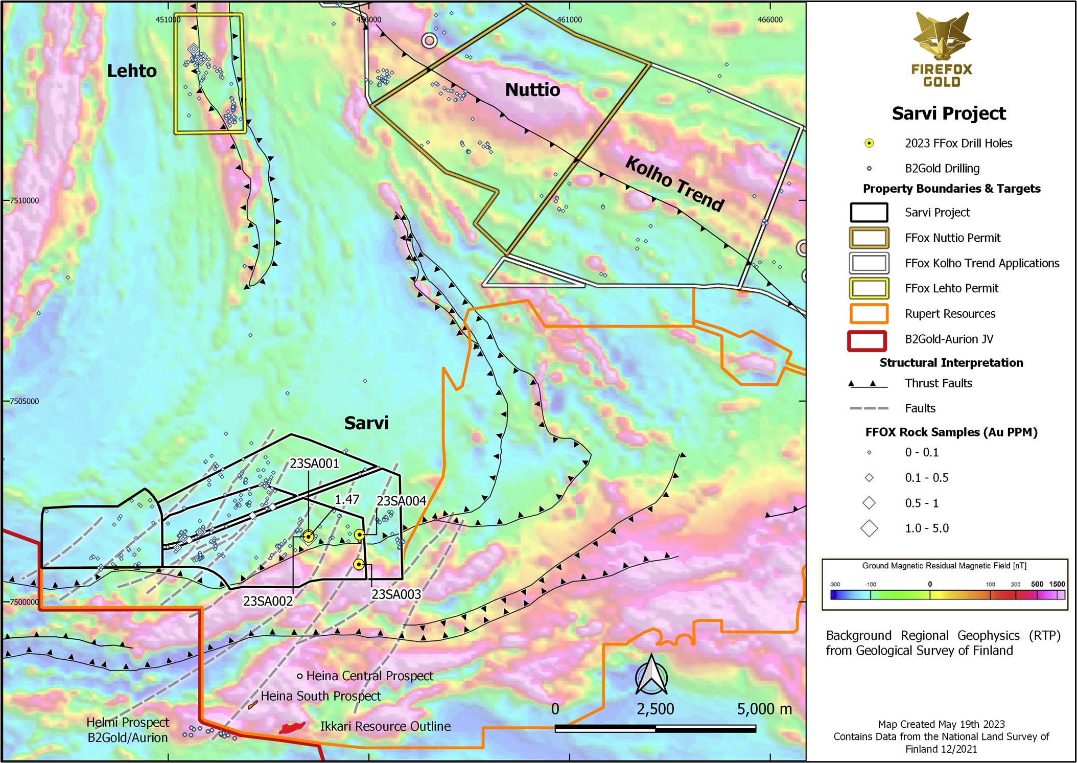
FireFox Gold (TSXV:FFOX) has announced the successful completion of a second diamond drilling operation at its wholly-owned Sarvi Gold Project, situated in Lapland, Finland.
The Sarvi Gold Project lies north of Rupert Resources’ Area 1 Project (Ikkari Deposit). The venture is based on the Sarvi exploration permit and encompasses two further permits, Sarvi-2 to the north and Keulakko to the west, making for a total authorized area of 21 square kilometres. The Sarvi permits cover a section of the Kittilä Suite of volcanic rocks, intersected by several interpreted faults.
FireFox’s CEO, Carl Löfberg, commented in a press release: “We continue to advance our portfolio of assets in Lapland, drilling on two of our five permitted projects during the winter 2023 program. Despite a shortened program at Sarvi due to the onset of spring conditions, the winter drilling was very valuable. The team identified sulphide minerals in three of the four holes and drilled an important sediment-volcanic contact. We can see evidence for multiple stages of deformation at the project along with anomalous gold, silver, and a suite of pathfinder elements that has been shown to be important in Lapland. As is the case for numerous projects in this area, outcrop is sparse, so we plan to expand our base-of-till sampling program to support more drilling. In the meantime, we look forward to receipt of the assays for these four holes.”
The recent exploration drilling program at Sarvi comprised four drill holes, spanning 611 meters. These holes were strategically designed to test a blend of geochemical anomalies from base-of-till (BoT) sampling and structural/geological targets. The project’s geological understanding has been enhanced through a combination of detailed magnetics from drone-based and ground surveys, supplemented with nearly 1,600 BoT samples. This latest drilling round identified quartz-carbonate (tourmaline) veining with sulphides, and sulphide-bearing carbonaceous sediments at a contact with mafic volcanic rocks. Notably, drilling in 2022 also discovered sulphide-rich graphite-bearing tuffs and schists that contained unusually high levels of gold and silver.
Unfortunately, the drilling operation was prematurely concluded due to the swift onset of thawing conditions. Results from the assay for all four drill holes are eagerly anticipated.
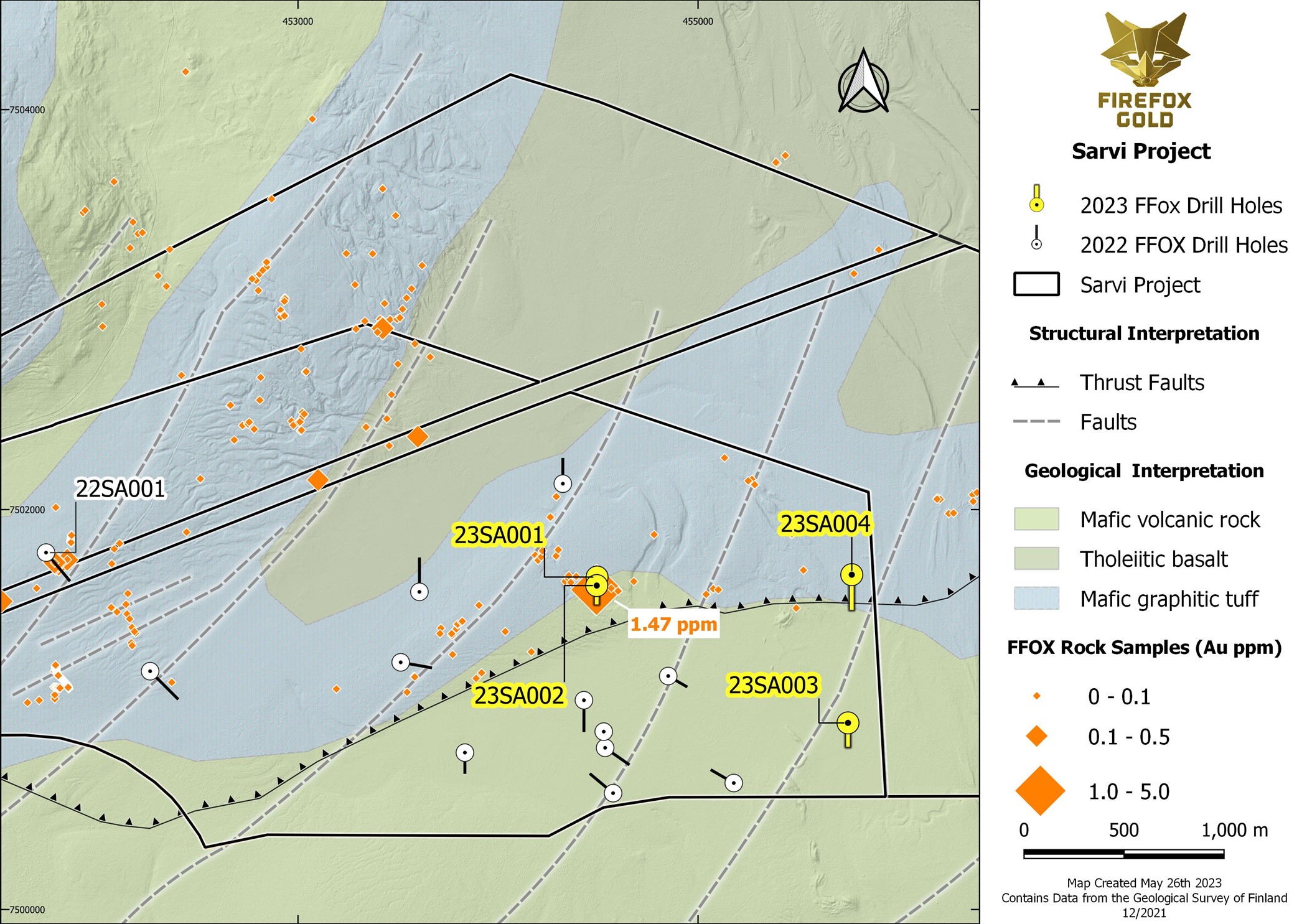
Geology and Details
Drill holes 23SA001 and 23SA002, positioned 42 meters apart, were drilled in a south-facing drill fence, targeting a steep magnetic gradient that corresponds with a surface rock sample that resulted in 1.47 g/t Au and 1.86% Cu (see FireFox’s news release dated August 24, 2021). These drill holes intersected mafic volcanic rocks, revealing signs of shearing, folding, and locally intense quartz-carbonate veining, inclusive of chalcopyrite, pyrite, tourmaline, and iron carbonate.
Drill hole 23SA003, drilled approximately 1.4 kilometers southeast of 23SA001 and SA002, explored a magnetic high area disrupted by late faulting, with BoT samples showing arsenic and copper anomalies. The drillhole was directed southwards and passed through a substantial section of mafic volcanic rocks.
Drill hole 23SA004, approximately 750 meters north of 23SA003, was aimed at a strong geochemical anomaly in the BoT sampling, marked by high silver, arsenic, bismuth, tellurium, and molybdenum levels. These elements are often enriched in Lapland gold systems. The hole intersected a sediment-volcanic contact with abundant pyrite in graphite-bearing mudstones and black shales, similar to the anomalous gold and silver intercept from the property’s west side in 2022. Following this interval, the drill hole passed through a gradational contact with mafic volcanic rocks (possibly tholeiitic basalts) around 91m downhole. This contact between the sulphide-bearing mudstones and the basalt provides crucial insights for the ongoing work at Sarvi.
Following this, the drilling fleet was relocated to the Mustajärvi Project area to conduct additional drilling around the high-grade East Target.
The above references an opinion and is for information purposes only. It is not intended to be investment advice. Seek a licensed professional for investment advice. The author is not an insider or shareholder of any of the companies mentioned above.
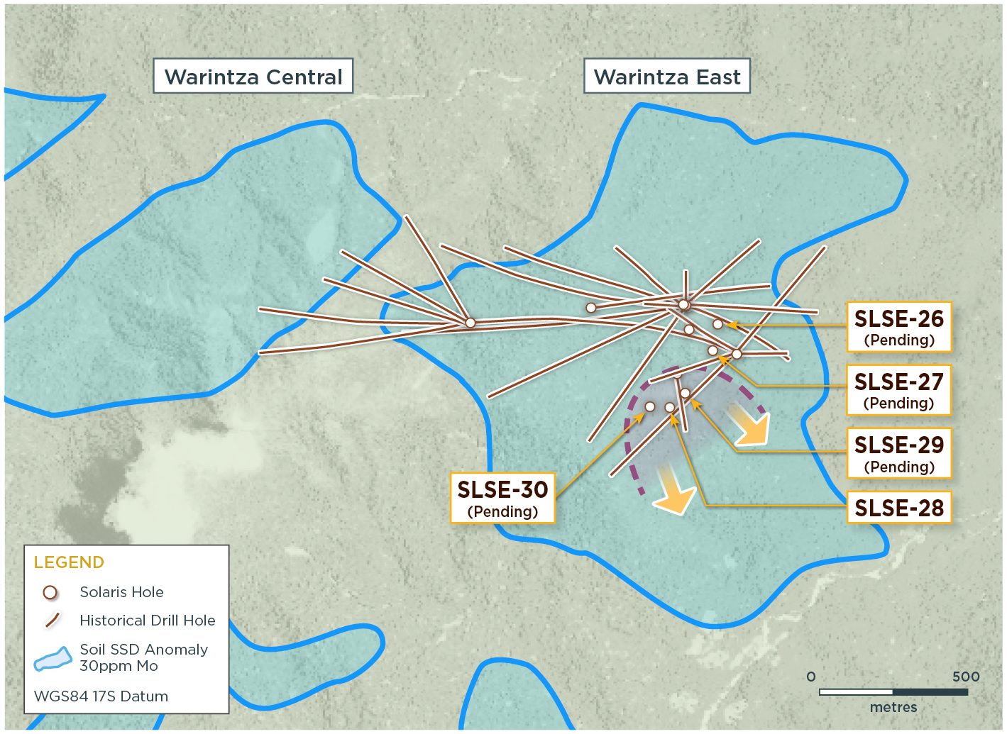
In a major announcement this morning, Solaris Resources (TSX: SLS) (OTCQB:SLSSF) has announced the confirmation of a new porphyry centre discovery at Warintza East. This second centre boasts the highest grade assays to date, beginning from the bedrock surface and extending right to the hole’s end.
This exciting new discovery, open to the east, west, south, and at depth, signifies a pivotal step forward in the Warintza Project’s exploration efforts situated in the southeastern region of Ecuador. This discovery has already sparked a series of follow-up drill operations, underlining its crucial role in the project.
Mr. Jorge Fierro, Vice President, Exploration, commented in a press release: “The discovery of a second, significantly higher grade porphyry center at Warintza East is a welcome surprise in our ongoing mineral resource growth drilling program. This new zone offers the potential to rapidly add near surface, high grade mineralization to the deposit that could contribute to future starter pit growth. Moreover, the zone is wide open with step-out and extension drilling coming soon.”
Solaris Resources, known for its diverse portfolio of gold and copper assets in the Americas, has been pioneering large-scale resource discovery and expansion efforts at the Warintza Project in Ecuador, which is currently its primary focus.
Beyond Warintza, the company sees promising discovery potential at their Ricardo and Tamarugo Projects in Chile, and their Capricho and Paco Orco projects in Peru. Solaris Resources also holds a 60% stake in the La Verde joint-venture project with a subsidiary of Teck Resources in Mexico.
Highlights from the results are as follows:
- Warintza East was discovered in July 2021, with eight drill holes included in the Warintza Central Mineral Resource Estimate (“MRE”)¹ in April 2022. Subsequent drilling has significantly expanded the dimensions of the deposit, with ongoing drilling targeting further mineral resource growth
- The latest drilling made an important discovery of a second, more intensely-mineralized porphyry center located outside the MRE, approximately 350m south of the original discovery, with assays now confirming the highest grades encountered at Warintza East to date
- SLSE-28 was collared to the south of the Warintza East drill grid and drilled vertically to the limit of the KD-200 rig, returning 301m of 0.65% CuEq² from bedrock surface at 8m depth to the end of the hole, with the final 31m averaging 0.76% CuEq²
- Two new platforms were constructed to the east and west, also outside the MRE, with follow-up drill hole SLSE-29 testing the southeast extension up to 200m to the east now completed and SLSE-30 in progress testing the potential to the west
- SLSE-29 and SLSE-30 were both drilled with KD-200 rigs to allow for the rapid expansion of this emerging zone of near surface, high grade mineralization, with follow-up deeper drilling planned with larger capacity KD-1400 rigs
- The new zone is wide open and additional follow-up drilling is planned to test the potential for lateral expansion, focusing on vectors to the south and southeast where new step-out platforms are under construction
Table 1 – Assay Results
| Hole ID | Date Reported | From (m) | To (m) | Interval (m) | Cu (%) | Mo (%) | Au (g/t) | CuEq² (%) |
| SLSE-28 | May 31, 2023 | 8 | 309 | 301 | 0.54 | 0.02 | 0.07 | 0.65 |
| Including | 278 | 309 | 31 | 0.68 | 0.01 | 0.07 | 0.76 |
Notes to table: True widths of the mineralized zone are not known at this time.
Table 2 – Collar Location
| Hole ID | Easting | Northing | Elevation (m) |
Depth (m) |
Azimuth (degrees) | Dip (degrees) |
| SLSE-28 | 801438 | 9647864 | 1162 | 309 | 0 | -90 |
| Notes to table: The coordinates are in WGS84 17S Datum. | ||||||
Endnotes
- Refer to Solaris’ technical report titled, “NI 43-101 Technical Report for the Warintza Project, Ecuador” with an effective date of April 1, 2022, prepared by Mario E. Rossi and filed on the Company’s SEDAR profile at www.sedar.com.
- Copper-equivalence calculated as: CuEq (%) = Cu (%) + 4.0476 × Mo (%) + 0.487 × Au (g/t), utilizing metal prices of US$3.50/lb Cu, US$15.00/lb Mo, and US$1,500/oz Au, and assumes recoveries of 90% Cu, 85% Mo, and 70% Au based on preliminary metallurgical test work.
The above references an opinion and is for information purposes only. It is not intended to be investment advice. Seek a licensed professional for investment advice. The author is not an insider or shareholder of any of the companies mentioned above.
If you would like to receive our free newsletter via email, simply enter your email address below & click subscribe.
 Follow us on Twitter
 Become our facebook fan
CONNECT WITH US
Tweets
Tweet with hash tag #miningfeeds or @miningfeeds and your tweets will be displayed across this site.
MOST ACTIVE MINING STOCKS
Daily Gainers
 CMC Metals Ltd. CMC Metals Ltd. |
CMB.V | +900.00% |
 Eden Energy Ltd Eden Energy Ltd |
EDE.AX | +200.00% |
| GoviEx Uranium Inc. |
GXU.V | +42.86% |
| Eagle Nickel Ltd. |
ENL.AX | +41.67% |
| Citigold Corp. Limited |
CTO.AX | +33.33% |
| Mount Burgess Mining NL |
MTB.AX | +33.33% |
| Exalt Resources Limited |
ERD.AX | +31.94% |
| Casa Minerals Inc. |
CASA.V | +30.00% |
| Cariboo Rose Resources Ltd |
CRB.V | +28.57% |
| Belmont Resources Inc. |
BEA.V | +28.57% |