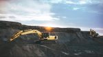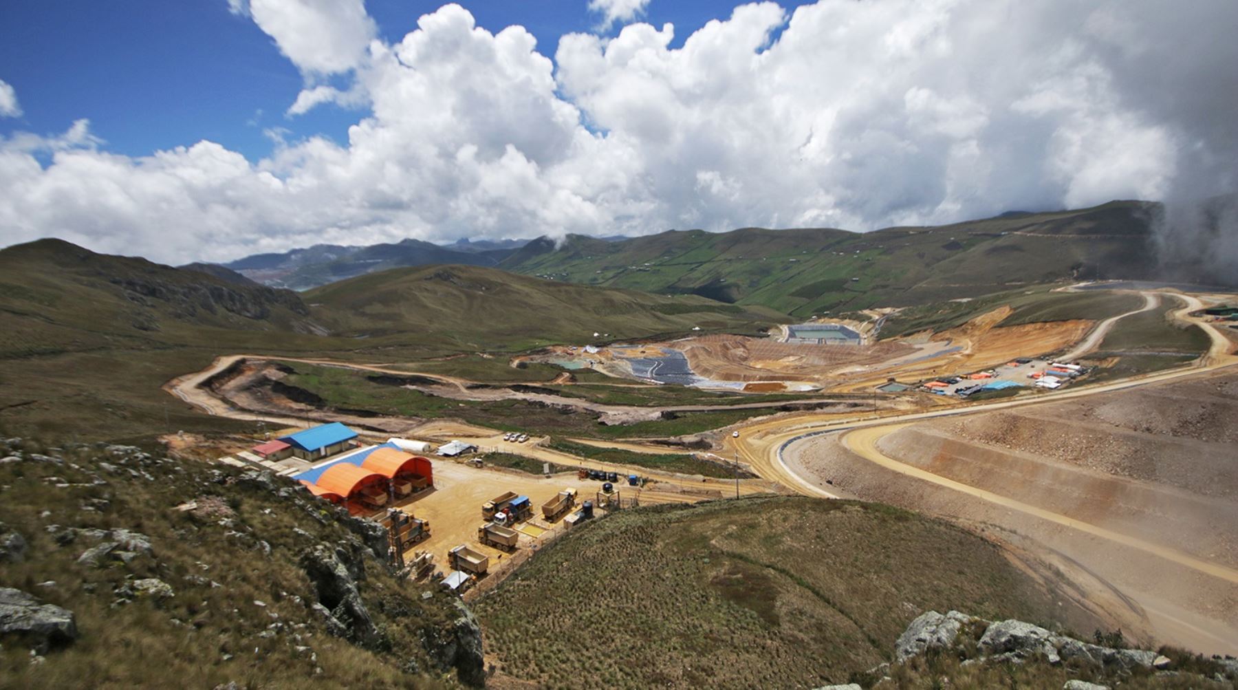
Rio Tinto (ASX:RIO) has entered into a joint venture agreement with First Quantum Minerals (TSX:FM) to unlock the development of the La Granja copper project in Peru. The project, located at high altitude in Cajamara, Northern Peru, is one of the largest undeveloped copper deposits in the world, with an estimated resource of 4.32 billion tonnes at 0.51% copper.
Under the agreement, First Quantum will acquire a 55% stake in the project for $105 million and invest up to $546 million to sole fund capital and operational costs, taking the project through a feasibility study and towards development. The transaction is expected to be completed by the end of Q3 2023.
As the majority owner, First Quantum will operate the La Granja project, with initial work focussed on completing the feasibility study. Rio Tinto had acquired the La Granja Project from the Government of Peru in 2006 and has since carried out extensive drilling programs to expand the declared resource and understanding of the orebody, and established partnerships with host communities, local and national governments.
La Granja is currently the fourth-largest copper project in the world, and Peru is the world’s second-largest copper producer. The agreement between Rio Tinto and First Quantum Minerals is expected to boost the Peruvian mining industry and create new job opportunities in the region. The joint venture will also provide the necessary capital to develop the La Granja project, which is expected to become a large, long-life operation, benefiting the local communities and the country’s economy.
The joint venture agreement between Rio Tinto and First Quantum Minerals to develop the La Granja copper project in Peru is not only significant for the South American nation’s mining industry, but also for the two global mining giants involved. For Rio Tinto, the move further strengthens its copper portfolio, which was recently boosted by the acquisition of Turquoise Hill Resources and the launch of underground mining at Oyu Tolgoi in Mongolia.
On the other hand, First Quantum Minerals has been in the news lately for its dispute with the Panamanian government over royalties, which led to a temporary halt in operations at its Cobre Panama mine earlier this year. The two parties reached an agreement in March that guarantees a minimum annual income of $375 million to the Panamanian government, allowing the mine to resume operations.
With the La Granja project now on the horizon, First Quantum Minerals is expected to focus its attention on unlocking the potential of one of the world’s largest undeveloped copper deposits. The joint venture will inject the necessary funds to take the project through a feasibility study and towards development, which is likely to create new job opportunities in the region and benefit local communities.
The above references an opinion and is for information purposes only. It is not intended to be investment advice. Seek a licensed professional for investment advice. The author is not an insider or shareholder of any of the companies mentioned above.
Brazil Potash is set to invest US$2.5bn in its Autazes potash project in Amazonas state, a significant step for the company and its flagship potash project. The project aims to extract and process sylvinite for the production of potassium chloride with a capacity of 2.2Mt/y. The Autazes project will be located 112km from Manaus, Amazonas state, and is expected to produce 20% of the volume consumed through Brazilian crops. The Autazes potash project is moving closer to approval and the inevitable and significant investment that will come with it, approaching the point where the company will begin to monetize the project through multiple channels and strategies.
Licensing and Financing Strategies
The project has already received the preliminary license issued by Amazonas’ environmental authority, Ipaam. The installation license from Ipaam is the only one remaining, and the company expects news regarding its licensing this year to begin building the project. Brazil Potash plans to invest US$2.5bn in the project and is working on several fronts in relation to funding.
The company has signed an offtake agreement with Brazilian agricultural conglomerate Amaggi, agreeing to buy 500,000t/y of the production for at least 15 years, helping the company in its search for financing. Brazil Potash has also received positive feedback from the development bank BNDES and is talking to other international development banks. The company is in talks with potential suppliers from Europe, North America, and China to purchase equipment.
Energy Supply and Logistics
To address the energy supply issue, Brazil Potash will build a 165 km transmission line to connect the project to the national grid. This will benefit the local population of around 200,000 people who currently use diesel oil to generate power for their homes. The project has an agreement with Hermasa from Amaggi group, which will deliver the product to ports in the region for logistics.
Importance of Investment in the Potash Mining Industry
Potash mining plays an essential role in agriculture as it is a vital element in the production of fertilizers. The Autazes project will produce a relevant amount of potassium chloride, which corresponds to 20% of the volume consumed through Brazilian crops. Potash mining in Brazil has been lagging behind other countries, and the Autazes project’s success will encourage more investment in the industry. Brazil Potash is committed to engaging local communities and indigenous peoples of the region, with the goal of having around 80% of the region’s people in its workforce.
With positive indications from development banks and an offtake agreement with a major agricultural conglomerate, Brazil Potash is well-positioned to move forward with the project and deliver the biggest new potash project in decades.
The above references an opinion and is for information purposes only. It is not intended to be investment advice. Seek a licensed professional for investment advice. The author is not an insider or shareholder of any of the companies mentioned above.
Solaris Resources Inc. (TSX:SLS) (OTCQB:SLSSF) has received an exercise of common share purchase warrants amounting to C$30.2 million since the release of the Company’s last quarterly results on November 8, 2022.
Notably, Mr. Richard Warke, the Company’s Executive Chairman, and Equinox Gold Corp. have exercised a total of 23.1 million warrants at a price of C$1.20, resulting in proceeds of C$27.7 million, which represents the final tranche of warrants held by these parties. After exercising the warrants, Equinox sold the remaining 7.5 million common shares of Solaris through the Toronto Stock Exchange.
The announcement comes on the heels of new assay results, with the company reporting on March 13, 2022 that ongoing drilling for resource expansion is enlarging the Northeast Extension of the ‘Indicative Starter Pit’, which encompasses an area of high-grade mineralization near the surface.
The mineralization has been estimated to be 180 Mt at 0.82% CuEq¹ (Indicated) and 107 Mt at 0.73% CuEq¹ (Inferred) based on the Warintza Mineral Resource Estimate² (“MRE”), which was derived from drilling conducted up to the end of 2021. Follow-up step-out drilling has been carried out, and the results are pending. Additional platforms are set to be constructed to continue drilling.
The above references an opinion and is for information purposes only. It is not intended to be investment advice. Seek a licensed professional for investment advice. The author is not an insider or shareholder of any of the companies mentioned above.
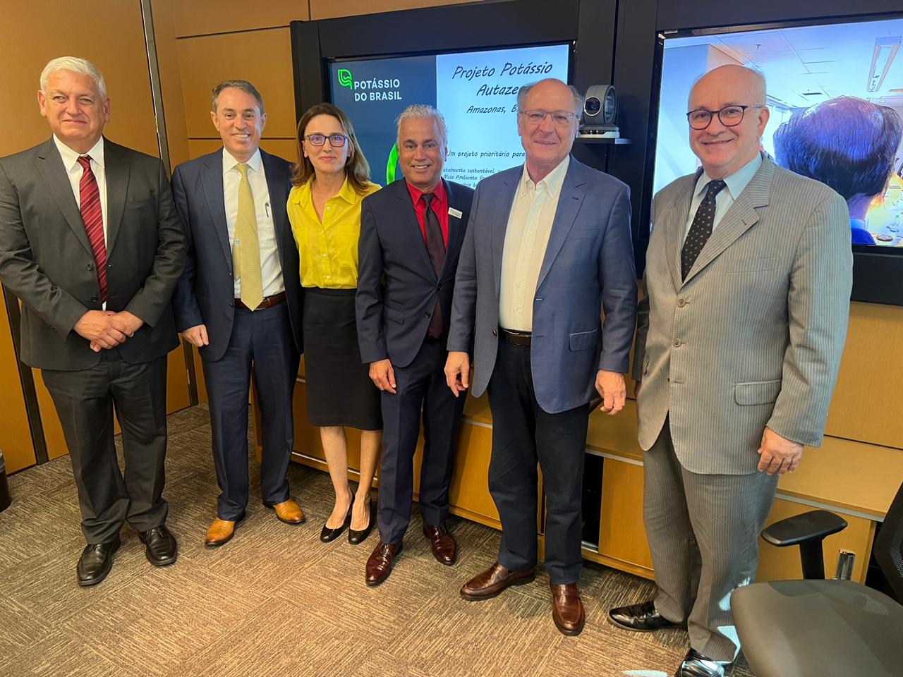
Potássio do Brasil’s President, Adriano Espeschit, and Chairman of Brazil Potash, Stan Bharti, recently presented the Autazes Potash Project to the new management of the Federal Government on March 3, 2023. The project was presented in Brasília to the Minister of Agriculture and Livestock, Carlos Fávaro, and his technical team, as well as to the Minister of Mines and Energy, Alexandre Silveira. The aim of the presentation was to seek the government’s support for the project, which will be implemented in the municipality of Autazes in the state of Amazonas.
The Autazes Potash Project is set to contribute significantly to Brazil’s self-sufficiency in the production of potash, a key component in fertilizer production. The project aims to extract 2.5 million tons of potash per year, which will be used domestically.
In a meeting with the Vice President of Brazil, Geraldo Alckmin, the Autazes Potash Project was presented by Espeschit, Bharti, and other members of the company’s board of directors. Alckmin, who is also the Minister of Development, Industry, Commerce and Services, praised the project and emphasized the need to strengthen the fertilizer industry in Brazil.
The Autazes Potash Project will also bring economic benefits to the region, providing job opportunities and boosting local infrastructure. The project will require an investment of approximately US$2.5 billion and is expected to generate over 5,000 direct and more than 10,000 indirect jobs during its construction and operation phases.
The Autazes Potash Project has already undergone extensive feasibility studies, and Potássio do Brasil is close to obtaining all the necessary environmental licenses to begin construction. The project will utilize the latest mining technologies and sustainable practices, including the use of renewable energy sources to power the operations.
The president of Potássio do Brasil, Adriano Espeschit, expressed his excitement about the project and the potential it holds for Brazil’s economy and environment. He also invited the Vice President, Geraldo Alckmin, to visit Autazes and see firsthand the positive impact the project will have on the region.
The Autazes Potash Project is set to become a significant contributor to Brazil’s fertilizer industry and a key player in the global potash market. The project’s successful implementation will help reduce Brazil’s dependence on foreign countries for potash and strengthen the country’s position as a leading producer of agricultural products.
The above references an opinion and is for information purposes only. It is not intended to be investment advice. Seek a licensed professional for investment advice. The author is not an insider or shareholder of any of the companies mentioned above.
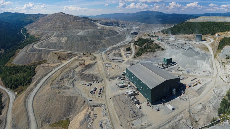
Copper Mountain Mining (TSX:CMMC), a Canadian mining company, has reported a strong year ahead with a substantial increase in production. The company’s flagship operation in southern British Columbia has achieved plant optimization and boosted the mineral reserve base, leading to the optimistic forecast.
In the full-year results released on Monday, Copper Mountain Mining projected copper production to reach between 88 million and 99 million pounds in 2023. This represents a significant improvement over the 52.9 million pounds of copper produced in 2022, which fell short of the company’s revised guidance of 55 million to 60 million pounds.
The lower-than-expected output coupled with high costs resulted in a net loss from continuing operations of C$58.9 million and an adjusted net loss of C$48 million for 2022. However, Copper Mountain Mining is confident that it has turned a corner and is poised for growth.
The company’s full-year 2022 C1 cash cost per pound of copper produced was $3.53, while all-in sustaining costs (AISC) per pound of copper was $4.20 and AISC per pound of copper was $4.78. Despite these costs, Copper Mountain Mining believes that the improvements it has made to its flagship operation will lead to greater efficiency and profitability in the years to come.
With copper prices on the rise and a strong demand for the metal in a variety of industries, Copper Mountain Mining’s optimistic forecast comes at an opportune time. The company is set to benefit from lower costs and increased production this year. The company has reported that its production is on track with its budget for 2023, with costs expected to be materially lower thanks to higher production and shorter haul distances.
Following the completion of plant improvement projects in 2022, Copper Mountain Mining expects mill throughput to be higher this year, averaging 45,000 tonnes per day, with recoveries expected to average approximately 84%. The company is forecasting an increase in production and grade, with the third quarter expected to be the strongest of the year. Mill feed is expected to come mainly from the higher-grade Phase 4 area and the North Pit.
Copper Mountain Mining is not only expecting to increase its copper production this year, but it also forecasts gold production to be between 20,000 and 30,000 ounces, and silver production between 350,000 and 400,000 ounces. This diversification of its metal portfolio is likely to provide the company with a more stable source of revenue.
The above references an opinion and is for information purposes only. It is not intended to be investment advice. Seek a licensed professional for investment advice. The author is not an insider or shareholder of any of the companies mentioned above.
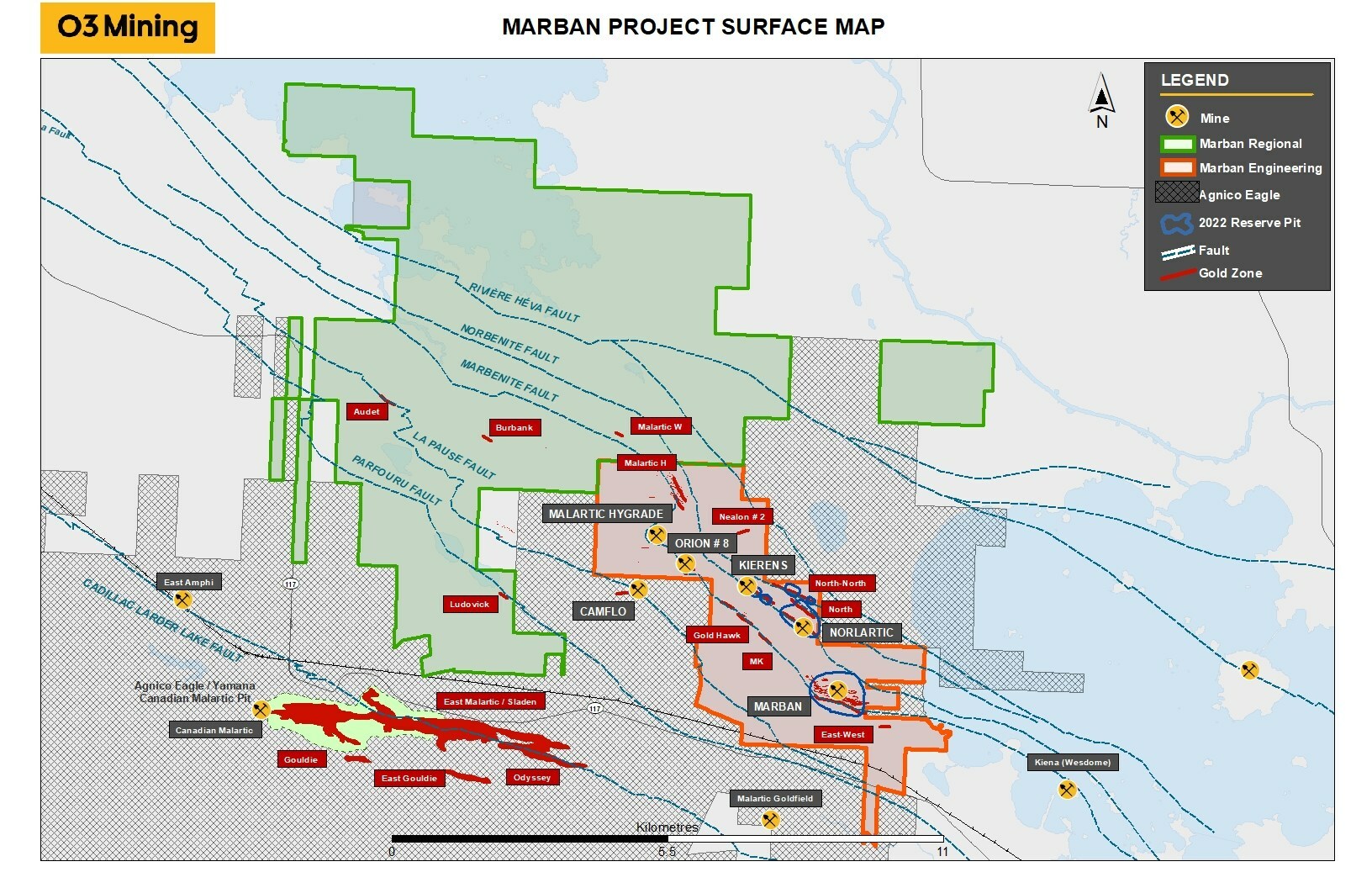
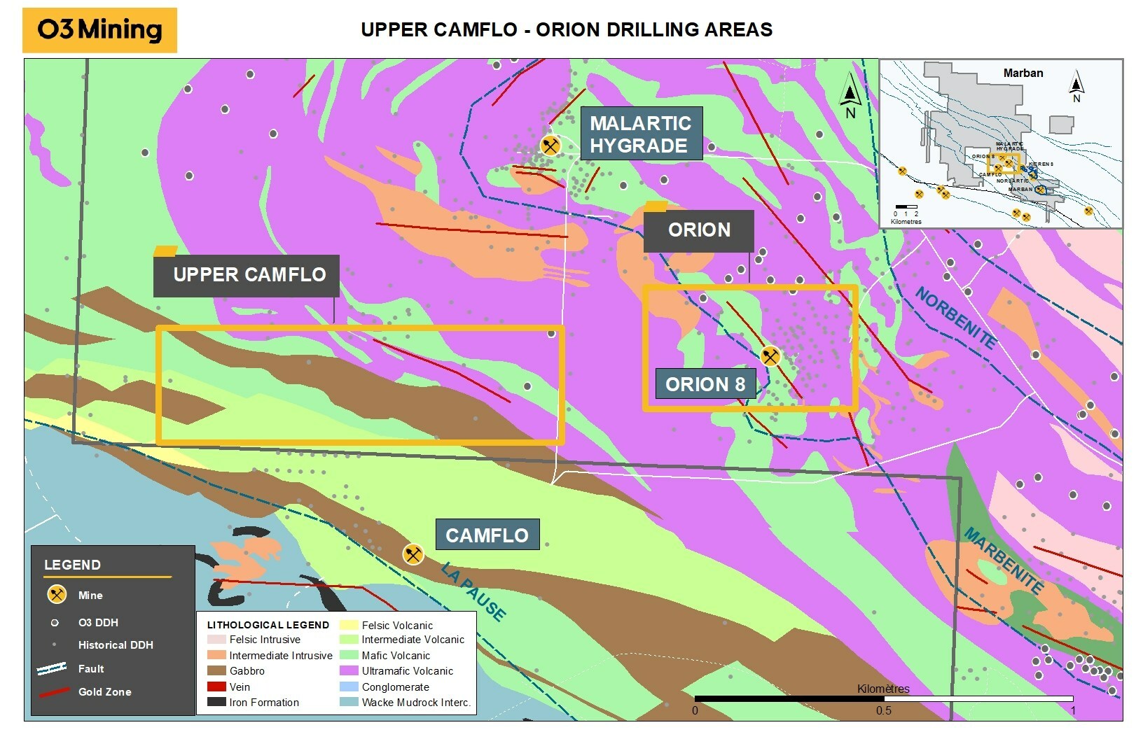
Montreal-based O3 Mining Inc. (TSXV:OIII) has announced the launch of its exploration program at the Marban Project, with the mobilization of two drills at Marban Engineering to focus on the Upper Camflo area and Orion deposit. The program, which includes 24,800 metres of drilling, aims to test an area of 800 metres along strike for near-surface gold mineralization.
O3 Mining’s President and Chief Executive Officer, Mr. Jose Vizquerra commented in a press release: “We are encouraged by the compilation work completed on the Camflo and Orion deposits and are excited to continue our drilling campaign on our Marban property in an effort to expand resources. Proximal to the historic Camflo mine, Upper Camflo and Orion offer the possibility of generating near surface resources in the halo of the past producers.”
The exploration program was initiated after a compilation of Barrick Gold’s historical drilling revealed parallel zones north of the Camflo mine. One of the zones was intersected by a series of holes drilled horizontally and toward the north from the border of the property at the 2400 mining level, 700 metres from surface.
The Orion mine, located in the Marban Project, produced 22,367 gold ounces from 131,000 tonnes at 5.3 g/t Au from 1987 to 1990. The zone is outcropping and surface channel samples have revealed a high-grade and wide auriferous zone, where the best channel samples returned 21.8 g/t Au over 11.2 metres.
As part of the exploration program, three drill holes will be used to validate historical high-grade assays outside the near-surface mining stopes. O3 Mining’s exploration efforts are supported by the Osisko team, which brings expertise and previous mine-building success to the table.
O3 Mining is a gold explorer and mine developer with properties covering a total of 66,000 hectares in Quebec. The company is well-capitalized and owns a 100% interest in all its properties, with several multi-million-ounce deposits in Quebec. The Marban Project is one of its highly prospective gold camps, which is on the road to becoming a gold producer.
Highlights from the announcement are as follows:
- O3 Mining to drill 1,500 metres near surface on the Upper Camflo area along the up-dip extension of a gold-bearing structure identified during the compilation of historical exploration drilling completed by Barrick Gold on the former Camflo mine.
O3 Mining to drill 900 metres near surface around the former Orion mine to confirm possible ore material left above and below the historical mining stopes.
The above references an opinion and is for information purposes only. It is not intended to be investment advice. Seek a licensed professional for investment advice. The author is not an insider or shareholder of any of the companies mentioned above.
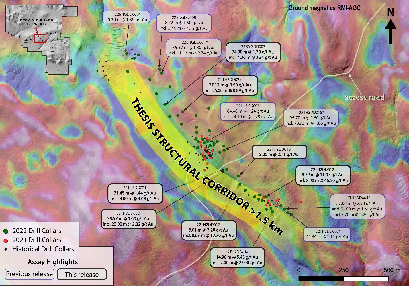
Thesis Gold (TSXV:TAU) has announced the latest assay results from its 2022 summer drill program at the Ranch Gold Project in British Columbia’s Toodoggone mining district. These results have significantly expanded the limits of the Bingo, Thesis III, and Thesis II zones, demonstrating gold mineralization along the more than 1.5-kilometre Thesis Structural Corridor.
Ewan Webster, President and CEO, commented in a press release: “From the outset of our drilling in the Thesis Structural Corridor, we believed that the system was much larger than previously documented. Today’s results continue to demonstrate our initial hypothesis was correct, we are now seeing significant growth come to fruition. The mineralization within the Corridor is showing excellent continuity along the 1.5 km strike extent, and as we continue to expand the mineralized footprint, we are discovering even more promising indications. Our team is currently planning for the 2023 drilling season, and the Thesis Structural Corridor is a primary focus for the upcoming campaign.”
Historically, the Bingo, Thesis III, and Thesis II zones were considered as three separate zones of mineralization. However, drilling by Thesis has shown that they are likely part of a continuous structure that spans over 1.5 km in strike length and continues downdip for at least 400 m. The mineral domain models further support this, indicating that the three zones are interconnected.
The mineralized intercepts from the northern and southern-most extents of the corridor returned significant gold intervals. The northwestern-most drillhole at Bingo returned 50.30 m core length of 1.86 g/t Au, while drilling from the southern Thesis II zone returned 59.00 m core length of 1.60 g/t Au. Additionally, high-grade mineralization within the corridor has returned intervals up to 33.13 m core length of 17.49 g/t Au.
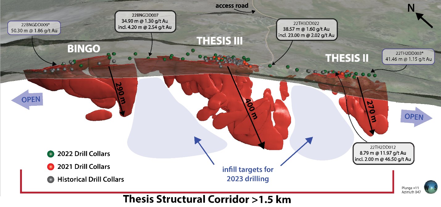
The geophysical expression of the Thesis Structural Corridor is best characterized by a 350-400 m-wide, NW-trending magnetic low that extends for over 4 km northwest and southeast, beyond the current limits of drilling. The linear trend is attributed to magnetic destruction, resulting from prolonged hydrothermal alteration along the TSC fault network.
Thesis Gold’s exploration work has shown that there is considerable potential for continued expansion of gold mineralization along the Thesis Structural Corridor. The continuation of the geophysical signature, in conjunction with strong gold mineralization at the flanks of the drill-tested area, indicates that there may be further opportunities for significant discoveries in the area.
All significant intercepts from the Thesis Structural Corridor have now been reported, and Thesis Gold is looking forward to continuing its exploration work in the region. These positive results have added to the company’s growing confidence in the potential of the Ranch Gold Project and its ability to deliver value to its stakeholders.
Highlights from the results are as follows:
- High-grade gold mineralization at Thesis II:
- 22TH2DD012 returned 8.79 metres (m) core length of 11.97 grams per tonne (g/t) gold (Au), including 2.00 m of 46.50 g/t Au (Table 1, Figure 2).
- 22TH2DD014 returned 14.90 m core length of 5.48 g/t Au including 2.00 m of 27.00 g/t Au.
- Infill drilling demonstrates mineralization along the 1.5 km-long portion of the Thesis Structural Corridor that has been drill tested to date (Figure 2).
- Between Thesis II and Thesis III, hole 22TH3DD022 returned 38.57 m of 1.6 g/t Au including 23.00 m of 2.02 g/t Au.
- Between Thesis III and Bingo, hole 22BNGDD007 intercepted 34.90 m of 1.30 g/t Au including 12.66 m of 1.73 g/t Au.
- Mineral domain modelling implies continuity along a 1.5 km trend that stretches from surface to over 400 m downdip in the Thesis III zone, and over 270 m in the Bingo and Thesis II zones.
- The Company will continue to test the Thesis Structural Corridor with both infill and expansion drilling, as the trend remains open both along strike and at depth.
Table 1: Drill core assay results from the Thesis Structural Corridor.
| Drillhole | From | To | Interval (m)* | Au (g/t) | Ag (g/t) | AuEq (Au/Ag)** | |
| 22TH2DD008 | 173.63 | 177.00 | 3.37 | 0.43 | 1.20 | 0.44 | |
| 22TH2DD009 | 134.58 | 140.00 | 5.42 | 0.74 | 0.60 | 0.74 | |
| incl. | 134.58 | 137.43 | 2.85 | 1.27 | 0.76 | 1.28 | |
| 22TH2DD010 | 124.17 | 128.67 | 4.50 | 0.81 | 0.61 | 0.82 | |
| 185.00 | 193.00 | 8.00 | 2.11 | 0.86 | 2.13 | ||
| incl. | 185.00 | 189.00 | 4.00 | 3.64 | 1.53 | 3.66 | |
| and incl. | 185.00 | 186.00 | 1.00 | 6.56 | 4.27 | 6.61 | |
| 317.00 | 328.00 | 11.00 | 0.69 | 0.64 | 0.70 | ||
| 22TH2DD011 | 28.90 | 32.00 | 3.10 | 2.77 | 0.56 | 2.78 | |
| incl. | 28.90 | 31.02 | 2.12 | 3.88 | 0.75 | 3.89 | |
| 43.00 | 45.00 | 2.00 | 0.21 | 0.08 | 0.22 | ||
| 69.00 | 70.00 | 1.00 | 0.27 | 0.14 | 0.27 | ||
| 22TH2DD012 | 138.00 | 146.79 | 8.79 | 11.97 | 10.49 | 12.10 | |
| incl. | 139.00 | 146.00 | 7.00 | 14.85 | 12.96 | 15.01 | |
| and incl. | 144.00 | 146.00 | 2.00 | 46.50 | 41.90 | 47.02 | |
| 22TH2DD013 | 23.16 | 57.24 | 34.08 | 0.87 | 1.72 | 0.89 | |
| Incl. | 23.16 | 34.00 | 10.84 | 1.75 | 4.34 | 1.81 | |
| 79.54 | 93.00 | 13.46 | 1.41 | 1.17 | 1.43 | ||
| Incl. | 80.00 | 87.22 | 7.22 | 2.26 | 1.74 | 2.28 | |
| 22TH2DD014 | 34.10 | 36.00 | 1.90 | 0.82 | 1.01 | 0.84 | |
| 56.00 | 59.00 | 3.00 | 0.03 | 51.60 | 0.68 | ||
| 130.10 | 145.00 | 14.90 | 5.48 | 8.20 | 5.58 | ||
| incl. | 131.00 | 141.57 | 10.57 | 7.61 | 11.33 | 7.75 | |
| and incl. | 133.00 | 135.00 | 2.00 | 27.00 | 33.80 | 27.42 | |
| 22TH2DD015 | 61.00 | 71.00 | 10.00 | 0.78 | 0.42 | 0.78 | |
| incl. | 61.00 | 62.00 | 1.00 | 6.04 | 0.10 | 6.04 | |
| 22TH2DD016 | 48.00 | 57.00 | 9.00 | 0.52 | 1.09 | 0.54 | |
| 22TH2DD017 | 30.45 | 38.46 | 8.01 | 3.20 | 0.72 | 3.21 | |
| incl. | 31.00 | 36.00 | 5.00 | 4.76 | 0.82 | 4.77 | |
| and incl. | 31.00 | 31.63 | 0.63 | 12.70 | 1.79 | 12.72 | |
| and incl. | 34.00 | 35.00 | 1.00 | 9.13 | 1.18 | 9.14 | |
| 22TH2DD018 | 35.00 | 40.00 | 5.00 | 1.16 | 0.51 | 1.17 | |
| 36.00 | 39.00 | 3.00 | 1.54 | 0.47 | 1.55 | ||
| 22TH3DD021 | 202.55 | 242.00 | 39.45 | 1.19 | 1.86 | 1.21 | |
| 202.55 | 234.00 | 31.45 | 1.44 | 2.23 | 1.47 | ||
| incl. | 204.00 | 212.00 | 8.00 | 4.08 | 7.20 | 4.17 | |
| and | 208.00 | 209.00 | 1.00 | 23.00 | 48.90 | 23.61 | |
| also incl. | 218.00 | 222.00 | 4.00 | 0.87 | 0.95 | 0.89 | |
| 281.00 | 284.00 | 3.00 | 0.42 | 0.27 | 0.43 | ||
| 22TH3DD022 | 113.21 | 123.74 | 10.53 | 0.36 | 1.17 | 0.37 | |
| 133.00 | 143.00 | 10.00 | 0.53 | 0.19 | 0.54 | ||
| 237.00 | 275.57 | 38.57 | 1.60 | 1.09 | 1.61 | ||
| incl. | 238.00 | 243.00 | 5.00 | 1.80 | 0.64 | 1.81 | |
| and incl. | 252.00 | 275.00 | 23.00 | 2.02 | 1.50 | 2.04 | |
| 22TH3DD025 | 23.00 | 50.12 | 27.12 | 0.59 | 1.84 | 0.61 | |
| 23.00 | 32.00 | 9.00 | 0.72 | 1.30 | 0.74 | ||
| 36.00 | 50.12 | 14.12 | 0.65 | 2.38 | 0.68 | ||
| incl. | 40.00 | 46.00 | 6.00 | 0.89 | 3.28 | 0.93 | |
| 22BNGDD006 | 137.87 | 164.57 | 26.70 | 0.49 | 2.76 | 0.53 | |
| incl. | 137.87 | 152.60 | 14.73 | 0.65 | 3.58 | 0.69 | |
| 175.72 | 188.49 | 12.77 | 0.62 | 4.37 | 0.68 | ||
| incl. | 184.91 | 187.54 | 2.63 | 1.25 | 7.89 | 1.35 | |
| 22BNGDD007 | 9.15 | 44.05 | 34.90 | 1.30 | 1.41 | 1.32 | |
| incl. | 13.00 | 23.00 | 10.00 | 1.66 | 1.17 | 1.67 | |
| incl. | 16.80 | 21.00 | 4.20 | 2.54 | 1.81 | 2.57 | |
| and incl. | 29.34 | 42.00 | 12.66 | 1.73 | 2.09 | 1.76 |
*True width of the intervals has not yet been established by drilling.
The above references an opinion and is for information purposes only. It is not intended to be investment advice. Seek a licensed professional for investment advice. The author is not an insider or shareholder of any of the companies mentioned above.
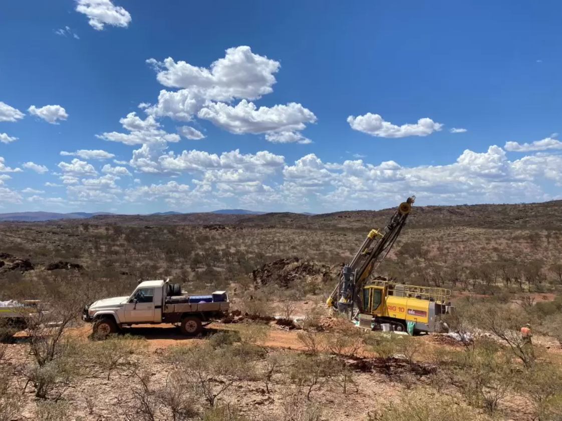
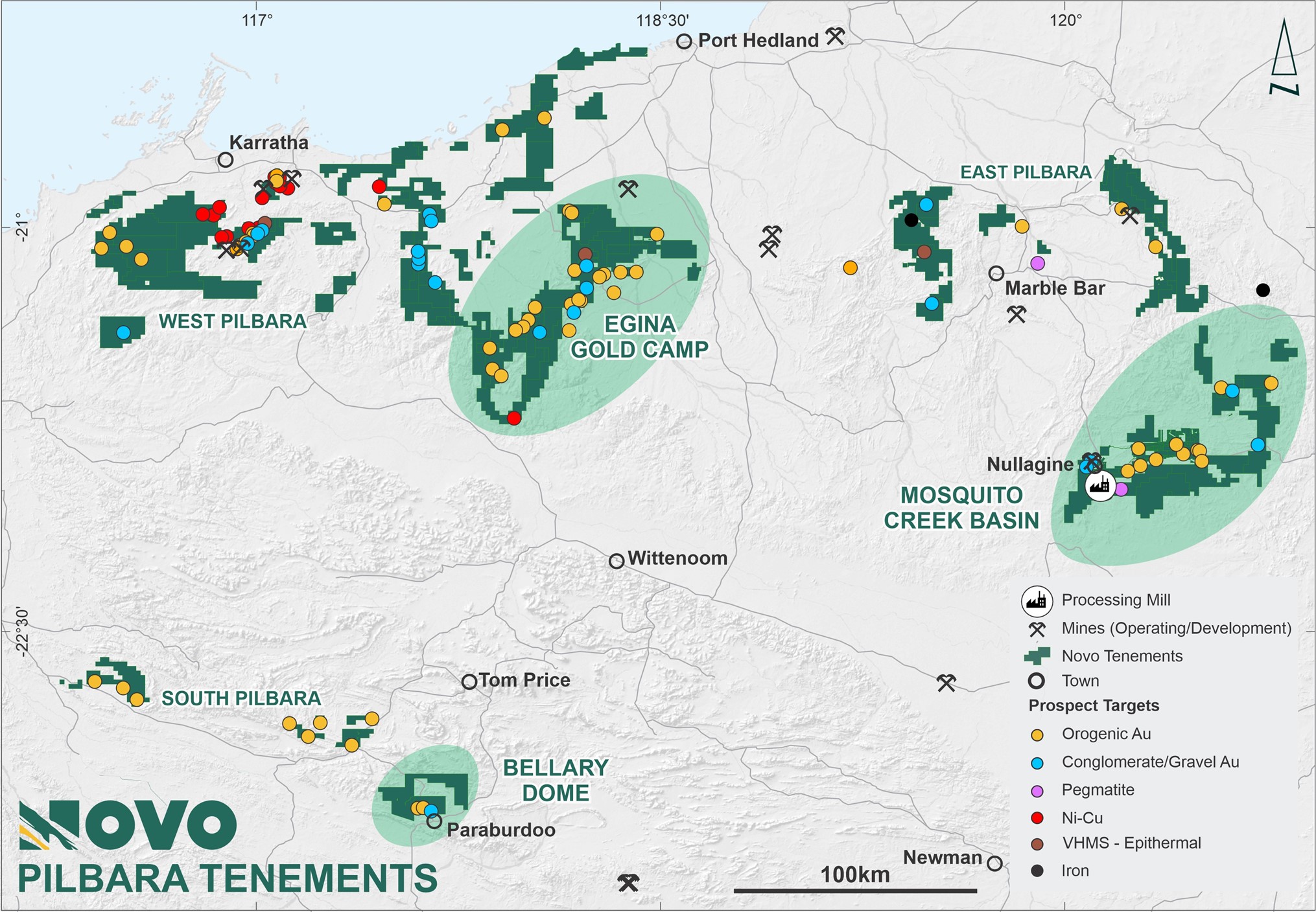
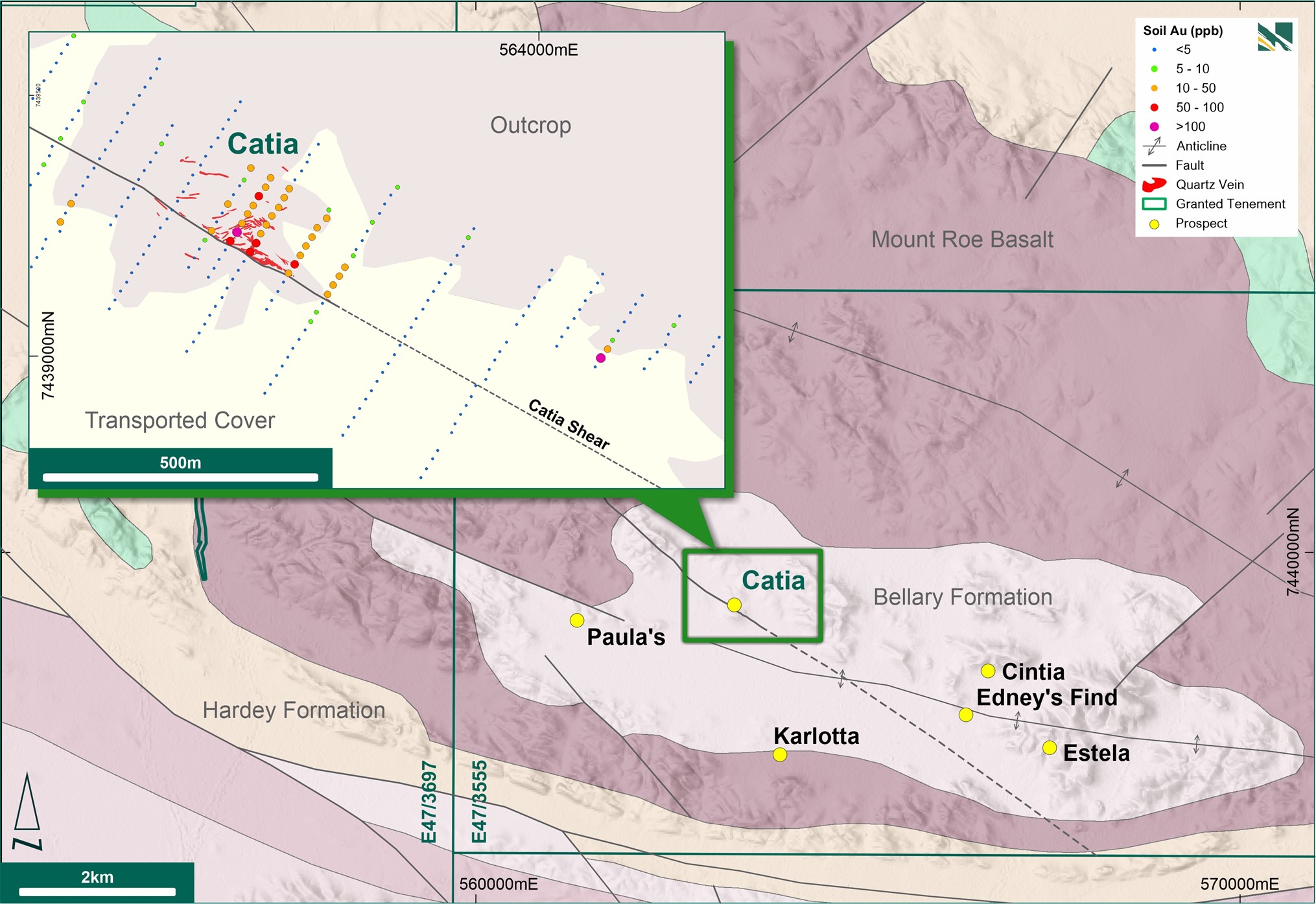
Novo Resources Corp. (TSX:NVO) has begun a reverse circulation (RC) drill program focused on the Catia Prospect and the Edney’s Find Prospect at the Bellary Dome Project in South Pilbara, Western Australia. The company has identified Bellary as one of its priority target areas across its significant 10,500 sq km landholding in the Pilbara.
Mike Spreadborough, Novo’s Executive Co-Chairman and Acting Chief Executive Officer, commented in a press release: “The Bellary Dome Project is one of Novo’s priority areas across its significant 10,500 sq km landholding in the Pilbara. We are excited to get on the ground and start testing these highly prospective targets, that were identified during our previous field work program. We anticipate the programme will take four weeks, with results released as they are received. This is the first of several drilling programs Novo plans for its current season of exploration.”
Novo entered into an option agreement with Bellary Dome Pty Ltd in June 2020 to acquire the gold-only rights on E47/3555, while Bellary Dome Pty Ltd retains the rights to all other minerals and ownership of the tenement under the agreement. The area of structural uplift along the southern margin of the Pilbara Craton has been identified by both historic and more recent explorers as having significant gold targets.
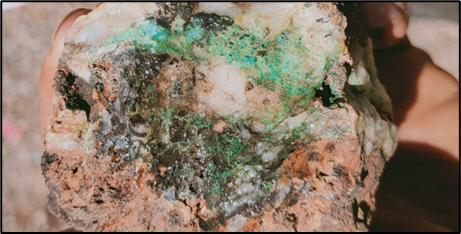
Fieldwork carried out by Novo and historical exploration reviews completed in 2020/2021 highlighted several gold targets, with Catia and Edney’s Find prioritised for drilling. Catia is a structurally complex area comprising sulphidic quartz veins hosted in highly foliated basalt and sedimentary rocks. It hosts a network of shallow and steep dipping gold-rich quartz veins within a regional west-northwest trending shear zone.
Rock chips from reconnaissance mapping and sampling by Novo returned significant anomalous gold values, with peak results of 556 ppm Au and 117 ppm Au. Additionally, broad-scale carbonate, silica, and sulphide alteration has been identified across all stratigraphic units at Bellary.
Soil sampling completed in 2021 by Novo highlighted a coherent bullseye Au-Ag-Pb-Sb anomaly in the immediate vicinity of the Catia vein system. It also identified a significant soil anomaly 700m further east-southeast from the prospect along what is interpreted as a continuation of the Catia Shear.
The commencement of the RC drill program is a positive development for Novo as it aims to further explore the gold potential of the Catia and Edney’s Find prospects at Bellary. Novo’s 10,500 sq km landholding in the Pilbara continues to be a priority target area for the company as it seeks to uncover new sources of gold.
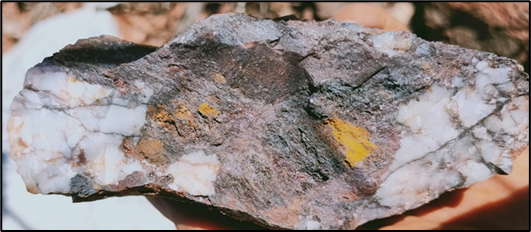
Exploration for gold at Edney’s Find, a conglomerate-hosted gold occurrence located in Western Australia, is gaining momentum as Novo Resources, a Canadian exploration company, plans to drill several short holes to test the area’s gold endowment.
Edney’s Find has been explored by various companies since the 1970s and is known for its significant historical and recent prospector activity. The area boasts of dry-blowing spoils, historic pits, and a small shaft, all of which indicate the presence of gold.
The region is dominated by Bellary Formation sediments, which comprise arkosic sandstone, quartzite, shale, and conglomerate. The conglomerate is clast-supported and has clast sizes that vary from pebble to cobble size. Furthermore, zones of the conglomerate show disseminated buckshot pyrite, up to 10mm in diameter.
Novo’s efforts have been fruitful, with a peak gold value of 36.4 ppm Au recorded in a trench rock chip sample in 2020. As a result, the company plans to drill several short holes to further test the gold endowment of the conglomerate.
Exploration in the region has been ongoing for several decades, and previous work includes mapping, surface sampling, trenching, and drilling. The conglomerate’s unique characteristics, combined with the region’s history of gold mining, have piqued the interest of explorers.
Highlights from the announcement are as follows:
- The Bellary Dome Project is one of Novo’s priority areas across its significant 10,500 sq km landholding in the Pilbara region of Western Australia.
- A 3,000 m reverse circulation drill program has commenced at the Catia Prospect, part of the Bellary Dome Project.
- Highly prospective gold mineralisation at Catia is structurally controlled and quartz vein related.
- High-grade gold results returned from rock chip sampling in 2021 include peak results of 556 ppm gold and 117 ppm gold.
- Step-out drilling will test the strike potential of the Catia Trend for 700 m along strike, under cover to the east of the Catia Prospect main target.
Results referred to in this news release are not necessarily representative of mineralisation throughout the Bellary area.
The above references an opinion and is for information purposes only. It is not intended to be investment advice. Seek a licensed professional for investment advice. The author is not an insider or shareholder of any of the companies mentioned above.
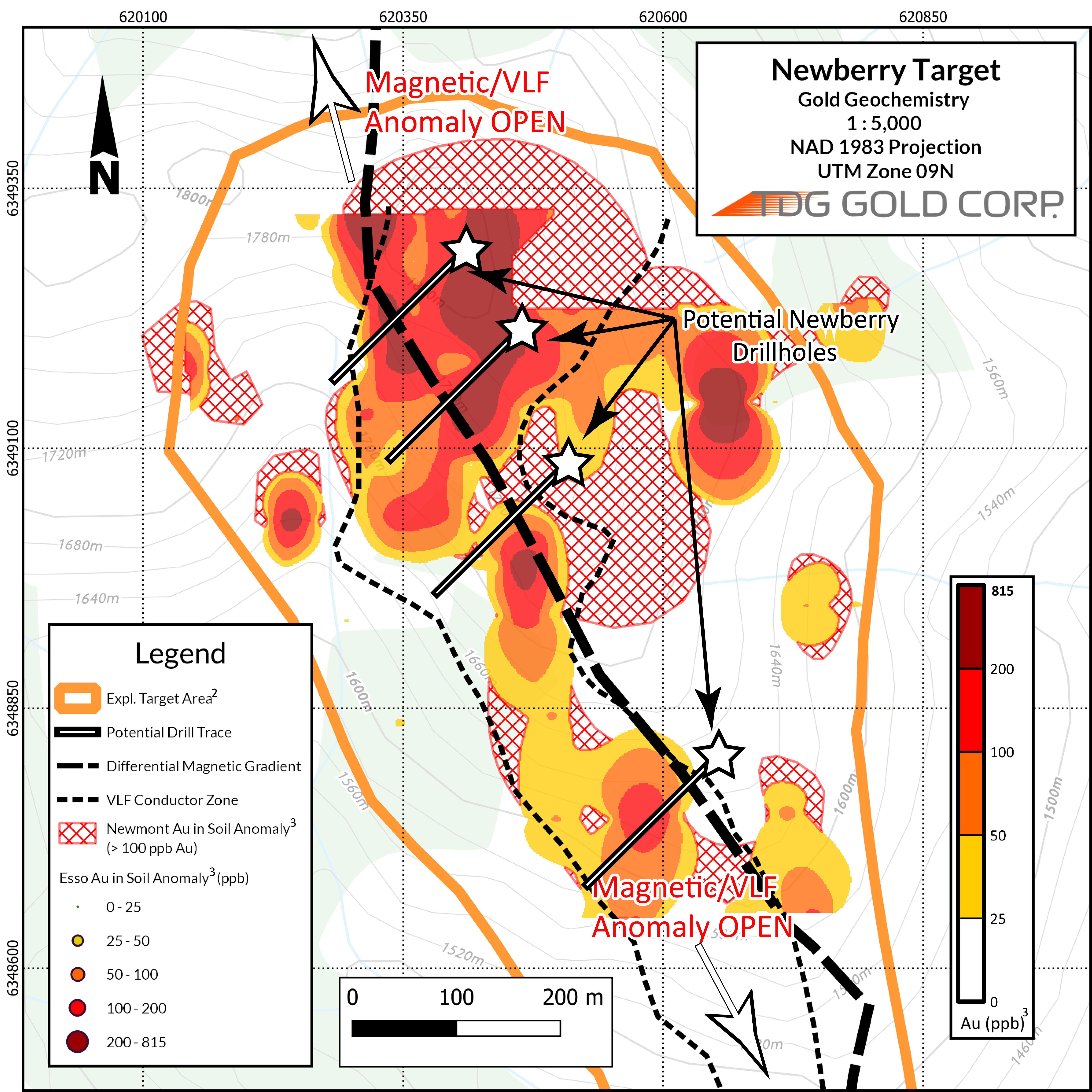
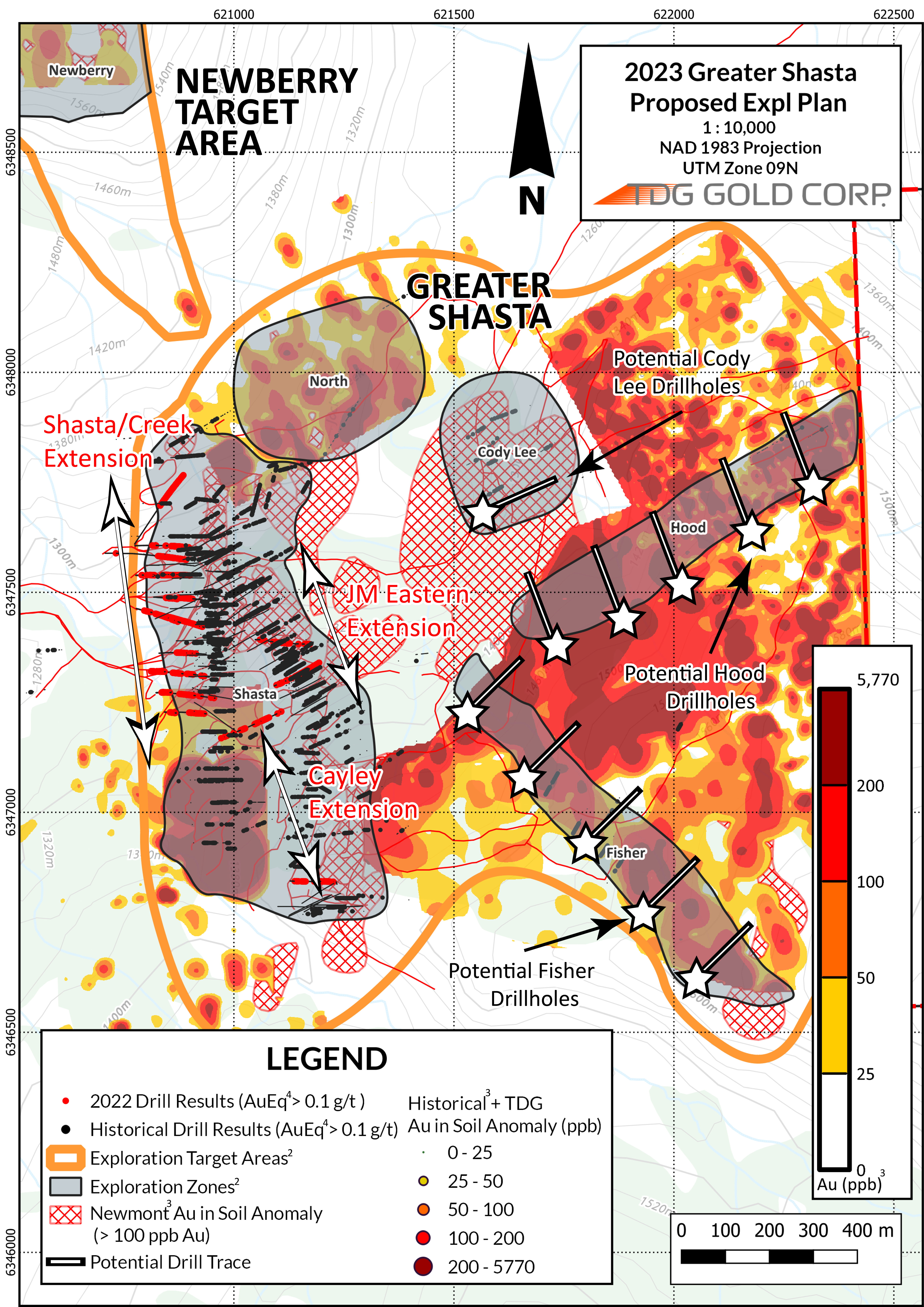
TDG Gold (TSXV:TDG) has announced the results of its drilling and exploration activities at the Shasta deposit in the Toodoggone gold-silver belt in 2022. The company has also shared its plans for the Greater Shasta-Newberry project area in 2023.
According to TDG Gold, the finalized assay results from the Shasta deposit drilling have been provided to Moose Mountain Technical Services (MMTS) to undertake an updated NI 43-101 Mineral Resource Estimate for the Shasta deposit. The updated estimate is expected to be completed by mid-2023.
The company has also announced plans to undertake updated geological mapping and soil geochemistry surveys to demonstrate continuity of the Au (and multielement) soil anomaly between Newberry and Greater Shasta, south of the Cayley-Rainier Zone to TDG’s claim boundary, and north of Newberry, which is currently open. This work will be complemented by an additional proposed 100 line-km of ground magnetics and Very Low-Frequency electromagnetic survey work to expand the surveyed area and the target footprint.
TDG Gold is a major mineral claim holder in the historical Toodoggone Production Corridor of north-central British Columbia, Canada, with over 23,000 hectares of brownfield and greenfield exploration opportunities under direct ownership or earn-in agreement.
Highlights from the ongoing interpretation of the 2022 Shasta drill results are as follows:
- Results from 5,008 metres (“m”) of diamond HQ, oriented core drilling extended the known mineralization at Shasta and indicates that the Shasta deposit remains open in all directions – including to the north towards the Newberry2 target.
- Gold-silver (“Au-Ag”) mineralization was intercepted at a shallower depth in Shasta West than previously modelled and at predicted depths in other directions, supporting geologic interpretation of mineralized trends.
- Two drillholes completed as southerly step-outs from the 2022 Shasta mineral resource area demonstrated on-trend mineralization extending further south by > 300 m.
- Vein orientation data, in combination with multi-element analytical data, has led to a reinterpretation of the geological and lithological models for Shasta, which TDG expects to improve future drill targeting at the Shasta deposit.
Highlights of the proposed 2023 drill program (all drilling will be diamond, HQ, and oriented core) are as follows:
- Newberry2 (Figure 1) – proposed initial 1,000 m of drilling in 4 drillholes, potentially leading to a further 2,000 m stepping on trend and down elevation towards Shasta North.
- Fisher Zone2 (Figure 2) – proposed initial 1,250 m of drilling in 5 drillholes along a 1-kilometre (“km”) Au-Ag soil anomaly.
- Hood2 and Cody Lee2 Zones (Figure 2) – complete historical core re-logging; proposed initial 1,500 m of drilling in 6 holes.
- Shasta Deposit2 (Figure 2) – complete historical core re-logging; proposed initial 2,500 m of drilling in 20 holes to test near-deposit extensions (Cayley, Eastern JM, Shasta/Creek).
The above references an opinion and is for information purposes only. It is not intended to be investment advice. Seek a licensed professional for investment advice. The author is not an insider or shareholder of any of the companies mentioned above.
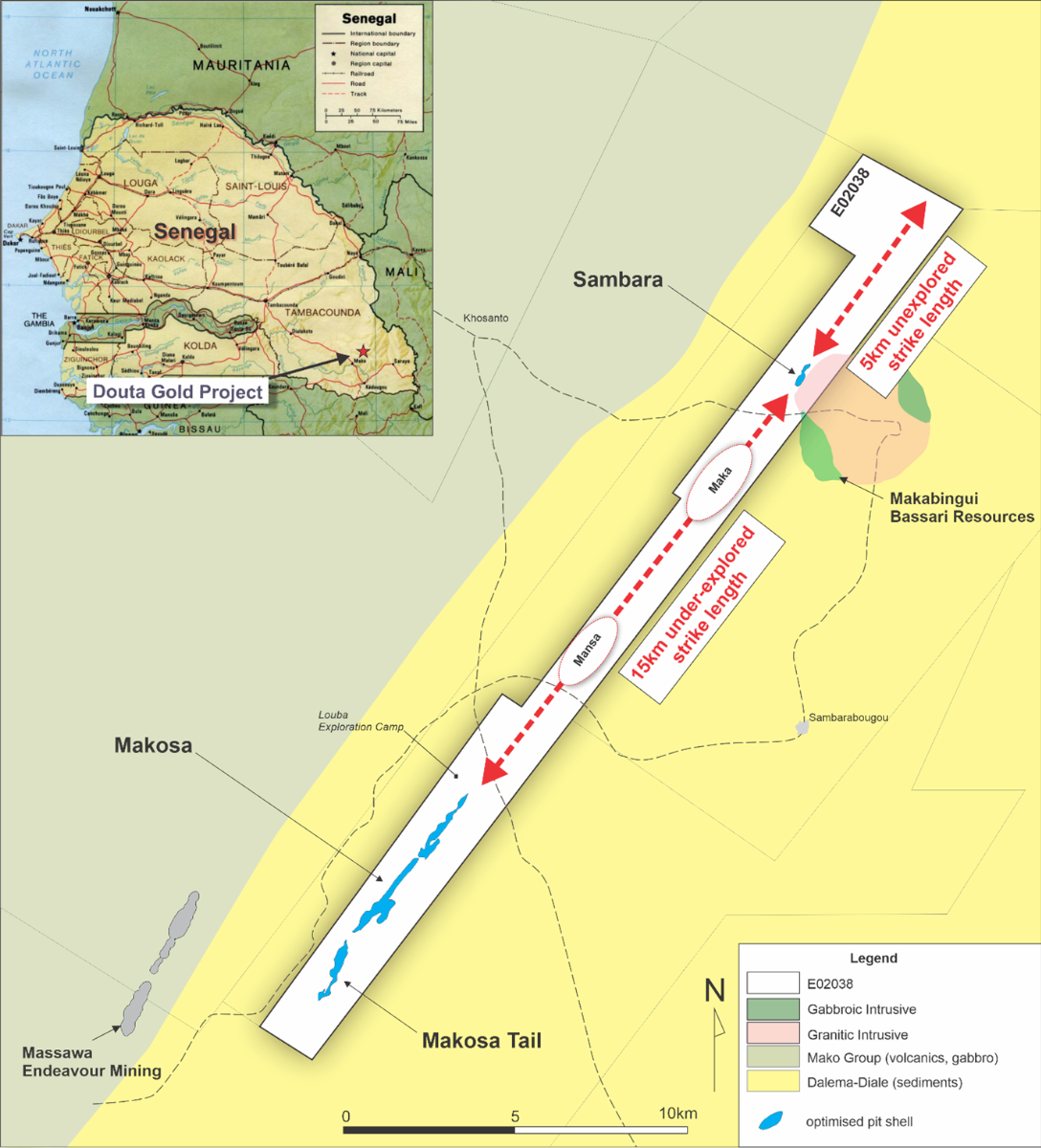
Thor Explorations (TSXV:THX), a Canadian mining company with operations in West Africa, has announced that its Douta project in Senegal could become its second gold mine in the region, following the discovery of more than twice the potential gold in the area. According to analysts, this new development provides the company with “greater confidence” in the project’s potential.
The Douta project currently holds an indicated resource of 20.2 million tonnes grading 1.3 grams of gold per tonne, with an inferred resource of 24.1 million tonnes grading 1.2 grams of gold per tonne. These figures translate to 874,900 oz. of contained metal for the indicated resource and 909,400 oz. of contained metal for the inferred resource.
The updated estimate now shows that the Douta project contains a total of 1.78 million oz. of contained gold, which is a significant increase of 144% compared to the initial resource estimate released in November 2021. At that time, the inferred resources totalled 730,000 oz. of gold in 15.3 million tonnes grading 1.5 grams gold.
Thor Explorations is now expected to focus on further exploration activities in the Douta project, with the aim of confirming the resource estimate and potentially expanding the size of the deposit. The company’s first gold mine in West Africa, the Segilola Gold Project in Nigeria, began production in 2021 and has since delivered strong operational results. With the promising results at Douta, Thor Explorations is well-positioned to continue its growth in the region.
Thor Explorations’ latest discovery of more gold in its Douta project in Senegal has been described as “impressive” by Echelon Capital Markets, indicating that it could become the company’s second gold mine in West Africa. The updated resource estimate shows a 144% increase in contained gold compared to the previous estimate released in November 2021. As a result, Thor is now planning further drilling activities to confirm the resource estimate and potentially expand the size of the deposit.
The Douta project, which lies in the far southeast of Senegal, is 70% owned by Thor, while the rest is held by local partner International Mining Co. The project includes the Makosa, Makosa Tail, and Sambara prospects, which remain open along strike and down-dip after 64,567 meters of drilling. The estimate used a cut-off grade of 0.5 gram gold per tonne within optimized open-pit shells, using a gold price of US$2,000 per ounce.

Thor Explorations is registered in Vancouver but does most of its business in London, where its shares trade at a discount to similar companies, according to Echelon. Despite this, Thor generally outperforms its peers regarding the growth of its cash flow and its all-in sustaining costs. The miner’s first gold mine in West Africa, the Segilola Gold Project in Nigeria, has already produced 98,000 oz. of gold, and the company is now poised to continue its growth in the region with the promising results at Douta.
Thor is now preparing a preliminary feasibility study for what could be an open-pit operation in Douta. Additionally, the company plans to undertake 40,000 meters of diamond and reverse circulation drilling this year. Mineralization remains open along strike between the prospects, with growth potential along 20 km of prospective strike length, the company said. Thor’s latest discovery of more gold in Douta is a promising development that could potentially lead to the opening of a new gold mine in West Africa.
Thor Explorations’ Douta project in Senegal has gained attention from mining analysts and investors after new figures showed a significant increase in the potential gold reserves. While Thor holds a 70% stake in Douta, its partner International Mining Co. holds a 30% free carried interest in the project until Thor declares a probable reserve. At that point, International Mining must either sell its interest to Thor or fund its pro-rata share of exploration and operating expenses. However, Thor has not yet provided clarification on the ownership of International Mining.
Located in the Kéniéba inlier, 4 km east of Endeavour Mining’s Sabadola-Massawa project, Douta covers an area of 58 sqkm. Bassari Resources is developing the Makabingui project immediately to the east. The updated resource estimate for Douta includes the Makosa, Makosa Tail, and Sambara prospects, all of which remain open along strike and down-dip. The company is planning to undertake further drilling activities to confirm the resource estimate and potentially expand the size of the deposit.
Echelon Capital Markets has noted that preliminary tests indicate that Douta’s oxide material may be recovered using gravity and carbon-in-leach methods, with biological oxidation and pressure oxidation methods also being assessed. The company aims to prepare a preliminary feasibility study for what could potentially be an open-pit operation in Douta. Endeavour’s Massawa achieved gold recoveries of 88% for similar rocks using biological oxidation processing, providing a positive outlook for Douta’s gold recovery potential.
Thor’s exploration efforts in West Africa have been promising so far, with the Segilola Gold Project in Nigeria already producing 98,000 oz. of gold. With the Douta project showing strong potential, the company is expected to continue its growth in the region.
The above references an opinion and is for information purposes only. It is not intended to be investment advice. Seek a licensed professional for investment advice. The author is not an insider or shareholder of any of the companies mentioned above.
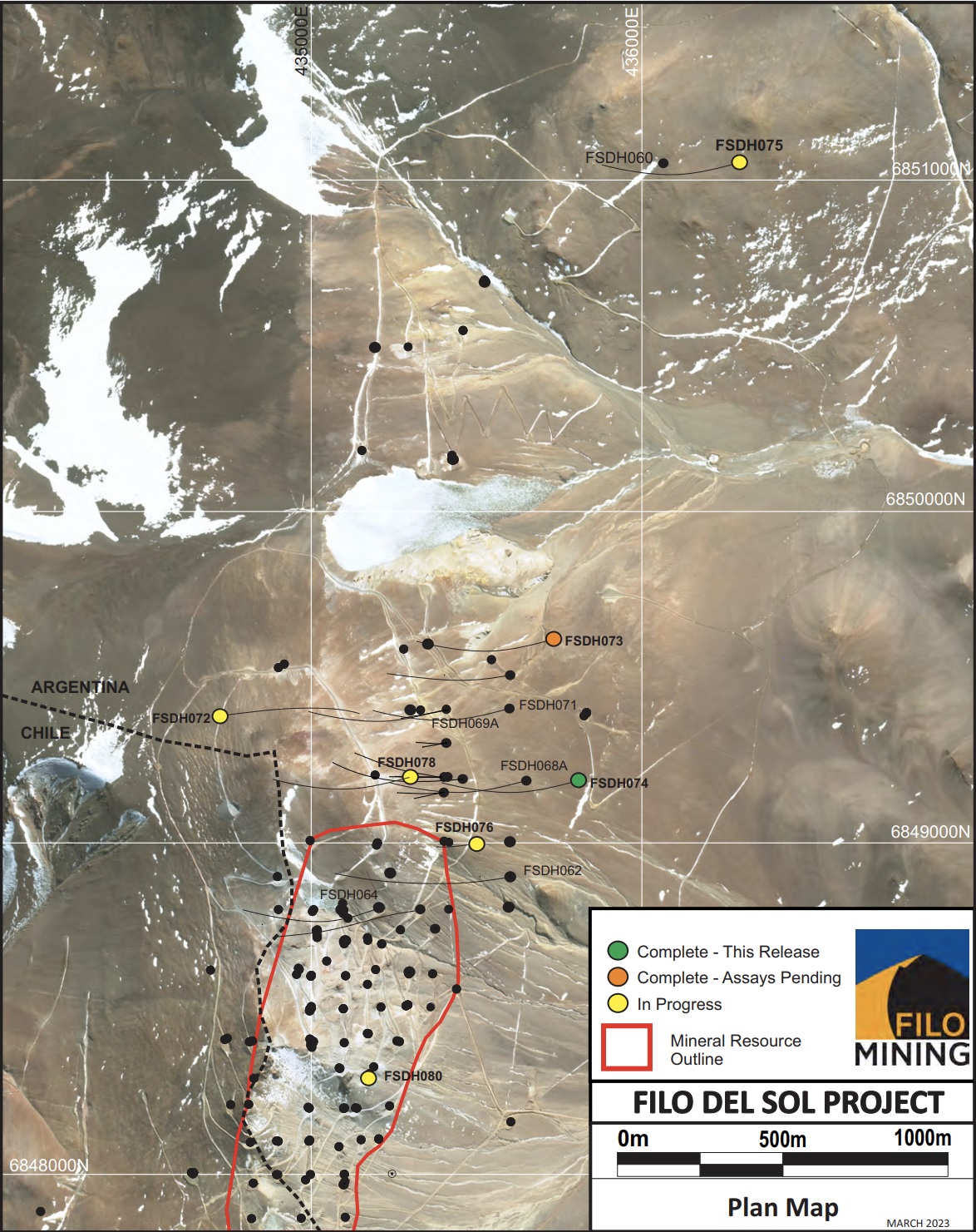
Filo Mining (TSX:FIL) has reported new assay results from the Filo del Sol Project in San Juan, Argentina. The results are from two holes: FSDH074 and FSDH077. Filo del Sol is a deposit of copper, gold, and silver formed by high-sulphidation epithermal processes. The deposit is linked with one or more significant porphyry copper-gold systems.
The mineralization events overlapped, and the effects of weathering have given rise to different types of mineralization, including structurally controlled and breccia-hosted gold, high-grade silver (with or without copper) in manto-style, and high-grade supergene enriched copper, alongside disseminated, stockwork, and breccia-hosted sulphide copper and gold mineralization.
Due to this complex geological history, the orebody displays a varied composition, featuring areas of exceptionally high-grade copper, gold, and silver mineralization within a more widespread envelope of less concentrated mineralization.
Jamie Beck, President, and CEO of Filo Mining, commented in a press release: “Hole 74 has successfully extended the Aurora Zone another 200m to the east of our previous drilling, confirming we have yet to find the east-west extents of mineralization. With each step-out, we build on the potential size of this remarkable Aurora Zone, while improving our geological interpretation of the deposit. I’m excited about what we learned from Hole 77 into our Flamenco target. Flamenco sits over 3km to the south of the Aurora Zone, and is characterized by a very large, 1.5km2, area of intense surface alteration similar to what we see over the Aurora Zone. With our first hole ever in this new zone, we’ve established mineralization is evident, and are planning additional drilling at Flamenco in order to properly evaluate the opportunity while chasing higher grades.”
Highlights from the results are as follows:
- Drillhole FSDH074 intersected 1,022.0m at 0.66% CuEq from a depth of 278.0m, including;
- 516.0m at 0.79% CuEq from 644.0m
- 252.0m at 0.85% CuEq from 840.0m
- Collared on Section 9200N, 200m east of FSDH068A and 400m east of FSDH041
- The hole was stopped in porphyry mineralization at 1,509.0m
- Drillhole FSDH077 intersected 2.0m at 10.35 g/t Au from a depth of 192.0m;
- Plus 516.2m at 0.20% CuEq from 404.0m
- Collared on Section 6000N, this is the first hole into the new Flamenco target
- The hole was stopped at 920.2m
| Hole ID | From | To | Length (m) | Cu % | Au g/t | Ag g/t | CuEq % |
| FSDH074 | 278.0 | 1300.0 | 1022.0 | 0.49 | 0.19 | 4.4 | 0.66 |
| incl | 644.0 | 1160.0 | 516.0 | 0.61 | 0.21 | 3.2 | 0.79 |
| incl | 840.0 | 1092.0 | 252.0 | 0.65 | 0.23 | 3.6 | 0.85 |
| FSDH077 | 192.0 | 194.0 | 2.0 | 0.05 | 10.35 | 0.5 | |
| plus | 404.0 | 920.2 | 516.2 | 0.11 | 0.11 | 0.9 | 0.20 |
| Mineralized zones within the Aurora Zone are bulk porphyry-style zones and drilled widths are interpreted to be very close to true widths. True width of the intersection in FSDH077 is unknown. |
FSDH074 was collared 200m east of hole FSDH068A on section 9200N, and drilled towards the west at an angle of -75 degrees. It was planned to test for the eastern and depth extension of the Aurora Zone intersected by FSDH041, FSDH055C, FSDH054 and FSDH068A, all on this same section. The hole is entirely outside of the resource pit shell.
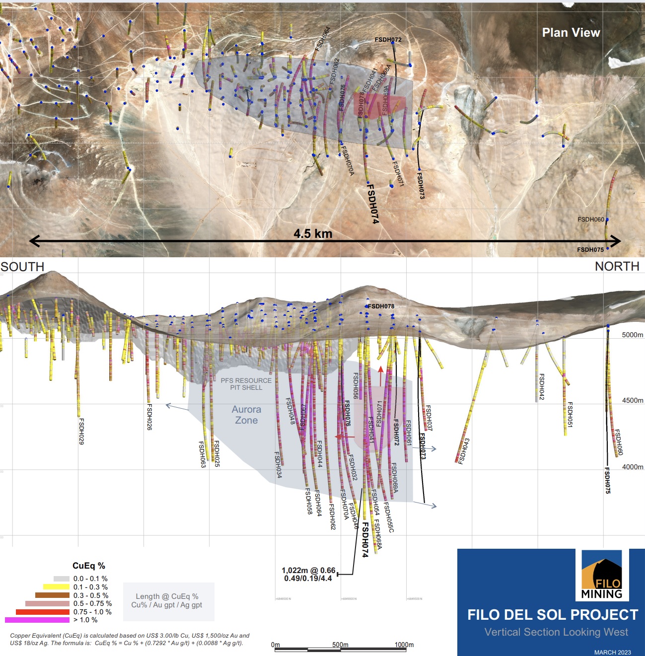
The geology in this hole was very similar to other holes on this section, and matched the geological interpretation very well. It intersected volcaniclastic and coherent rhyolite from surface to a depth of about 724m where the main mineralized breccia was intersected. The rhyolite sequence was well mineralized from a depth of 400m with the grade increasing on approach to the breccia.
The hole continues in breccia to about 1,260m where it enters a mixed interval of porphyry and breccia to 1,300m, transitioning to a multi-phase porphyry interval which continues to 1,458.0m where breccia is again encountered and persists to the end of the hole at 1,509.0m. The porphyry section is primarily the lower-grade late-mineral phase, but grades increase again in the breccia with the final 5m of the hole averaging 0.46% Cu.
FSDH074 extends the Aurora Zone 200m to the east, and together with the other holes on this section, builds on the potential width of this Zone. Additional drilling to the east and to the west is required to determine the full width of the Zone.
FSDH077 was drilled on Section 6000N, towards the west at an angle of -70 degrees. This is the first hole drilled into the Flamenco target and there are no other holes within 500m of it.
The most significant interval is a 2m section at 10.35 g/t Au within a narrow sulphide-rich zone possibly associated with a fault. In addition to this interval, there are long sections of low-grade mineralization, although no significant intervals above 0.3% CuEq. A 516.2m section from 404.0m to the end of the hole at 920.2m averaged 0.20% CuEq (0.11% Cu, 0.11 g/t Au, 0.9 g/t Ag).
The hole intersected weak quartz-alunite altered rhyolites cut by mafic intrusions over its entire length. Flamenco is a large target area characterized by abundant massive silica alteration over an area of about 1.5 square kilometres at surface, and additional drilling is required to fully test it.
The above references an opinion and is for information purposes only. It is not intended to be investment advice. Seek a licensed professional for investment advice. The author is not an insider or shareholder of any of the companies mentioned above.
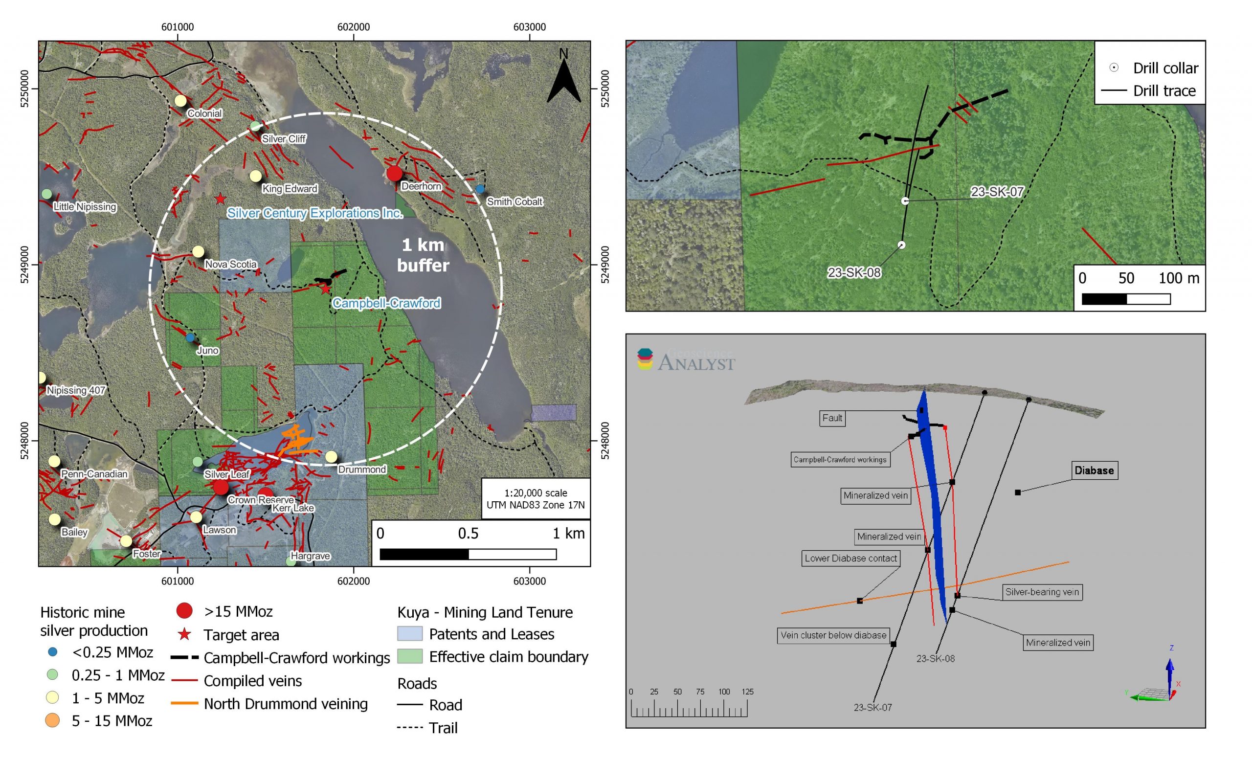
Kuya Silver (CSE:KUYA) has made an exciting new discovery at its Campbell-Crawford area of the Silver Kings Project in the Cobalt, Ontario mining camp. The company has intersected native silver mineralization in drill core, signalling the potential for a significant new source of silver in the region.
The discovery is located within a 1 km radius of five major mines that have produced a total of 48.2 million ounces of silver historically. This is a highly promising development for Kuya Silver, as it suggests that the area may have a wealth of untapped resources that could be exploited for commercial gain.
According to the company’s latest announcement, the new discovery is less than 1 km north of the North Drummond area and 750 m southeast of a 1,300 oz/t silver intercept from 1981 underground drilling by Silver Century Explorations Ltd. This makes it a highly strategic location, with the potential to yield significant amounts of silver for years to come.
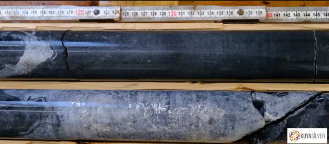
David Lewis, Kuya Silver’s Exploration Director, commented in a press release: “Despite more than a century of intensive mining and exploration, the legendary Cobalt mining camp can still generate exciting results. The Campbell-Crawford area was known to host low-grade mineralization on surface and in shallow exploration tunnels, but it had never been tested systematically. Work by Kuya Silver personnel in 2022 identified the area to host favorable structures for mineralization, particularly at depth (specifically at the lower contact of the Nipissing Diabase), and two drill holes were planned to test near this contact.”
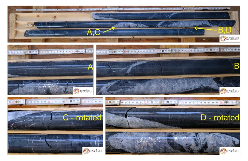
“The first drill hole (23-SK-07) intersected previously known, narrow mineralized veins adjacent to a fault within the diabase, then the lower diabase contact, then four previously unknown narrow mineralized veins at depth. The second hole (23-SK-08), which was stepped back and drilled beneath the first drill hole, intersected the first of the previously known veins immediately below the diabase contact. We were very excited to see the silver mineralization in drill core, confirming our exploration model for the area.”
Highlights from the results are as follows:
- Native silver was intersected in the second drill hole at the Campbell-Crawford area and drilling is ongoing along trend
- Mineralization in this vein appears to be primarily native silver, but minor cobalt mineralization is also recognized
- Silver stringers occur above and below the silver vein, significantly increasing the potential width of mineralization
- Drill intersection was made 170 m below the nearest underground workings (1910s exploratory tunnelling) and 230 m below surface
- The Campbell-Crawford area, despite being surrounded by historic mines and mineral occurrences, has remained virtually untested since exploration occurred in the early twentieth century and the area has never been mined
- Assay results are pending
The above references an opinion and is for information purposes only. It is not intended to be investment advice. Seek a licensed professional for investment advice. The author is not an insider or shareholder of any of the companies mentioned above.
Faraday Copper (TSX:FDY) has reported new assay results from three drill holes at its Copper Creek Project in Arizona. The company is targeting the potential expansion of the open pit mineral resource with these holes and has seen significant results. Faraday’s Copper Creek Project is one of the largest undeveloped copper projects on the continent.
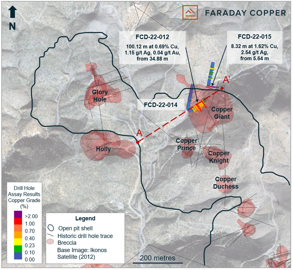
It contains both open pit and bulk underground mining potential, for which the company is well-funded to deliver on. Faraday is composed of an experienced management team and board of directors that bring a range of expertise to the project and the ongoing mineral resource expansion.
To-date, the company has completed 16 drill holes at the project with results for nine of the drill holes already released. Results are being released as they are received, analyzed and confirmed by Faraday.
Paul Harbidge, President and CEO of Faraday Copper, commented in a press release: “This is one of the most exciting results from our Phase II drill program as it continues to demonstrate the potential to expand the open pit mineral resource. Importantly, mineralization remains open. This result is extremely encouraging for the growth potential of the Copper Creek project.”
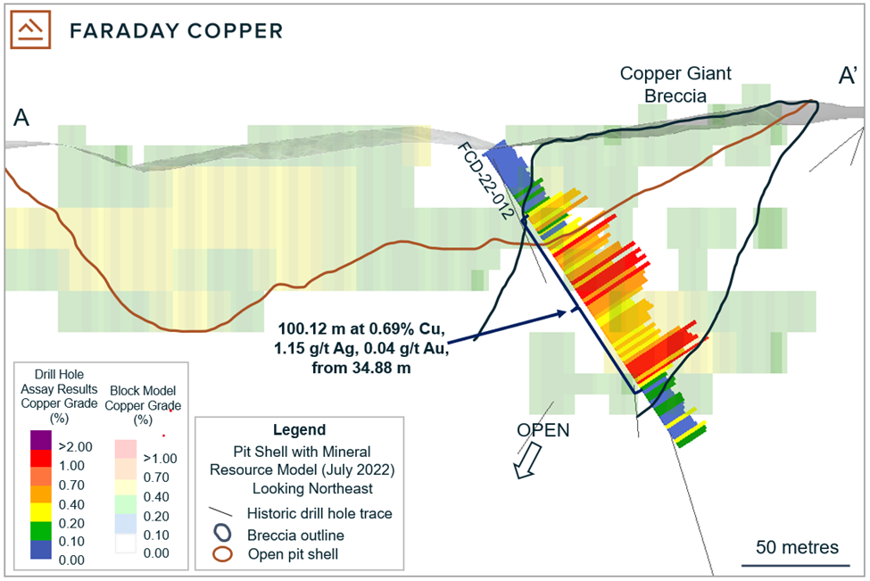
Highlights from the results are as follows:
- Intersected 100.12 metres (“m”) at 0.69% copper and 1.15 grams per tonne (“g/t”) silver from 34.88 m at the Copper Giant breccia in drill hole FCD-22-012. Approximately 85 m of this intersection are outside the pit shell used to constrain the Mineral Resource Estimate (“MRE”) and provide the potential for an increase to the current open pit resource (Table 1, Figures 1, 2). Mineralization remains open at depth and to the southwest; and
- Intersected 8.32 m at 1.62% copper and 2.54 g/t silver from 5.64 m, and 9.64 m at 0.31% copper and 1.15 g/t silver from 110.55 m in drill hole FCD-22-015. Both intersections are located outside of the MRE and demonstrate that the area north of Copper Giant remains prospective (Figure 1).
Drill hole FCD-22-012 was collared west of the Copper Giant breccia and drilled to the northeast. The mineralization occurs as chalcopyrite breccia cement within Copper Giant and highlights that the copper grade, continuity and volume of this mineralized domain may be significantly larger than the historic drilling suggested. Mineralization remains open at depth and to the southwest (Figures 1 and 2).
Drill hole FCD-22-015 was collared approximately 120 m to the northeast from drill hole FCD-22-014 and is located entirely outside of the MRE. The hole was drilled to the north into Glory Hole volcanics and granodiorite porphyry, where no previous drill data existed. The hole intersected high-grade, breccia-hosted mineralization from 5.64 m to 13.96 m. In addition, 9.64 m of copper mineralization was intersected within a wide sericite alteration halo between 75 m and the end of the hole at 156.60 m. Sericite alteration can be associated with high-grade mineralization in the district and this result merits additional drill testing.
Drill hole FCD-22-014 was collared at the same location as FCD-22-012 but drilled to the north. This hole was drilled into the Glory Hole volcanic host rock where no previous drill data existed. While no significant copper mineralization was identified, portions of this hole have intersected potassic and sericite alteration, suggesting that the hydrothermal system continues to the north from the current extent of drilling and, therefore, it remains a drill target.
Table 1: Selected Drill Results from Copper Creek
| Drill Hole ID | From | To | Length | True Width | Cu | Mo | Au | Ag |
| (m) | (m) | (m) | (m) | (%) | (ppm) | (g/t) | (g/t) | |
| FCD-22-012 | 34.88 | 135.00 | 100.12 | 71 | 0.69 | 25 | 0.04 | 1.15 |
| Including | 120.00 | 133.23 | 13.23 | 10 | 1.13 | 44 | 0.07 | 2.10 |
| FCD-22-015 | 5.64 | 13.96 | 8.32 | 8 | 1.62 | 74 | N/A | 2.54 |
| and | 110.55 | 120.18 | 9.64 | 9 | 0.31 | 18 | N/A | 1.15 |
| FCD-22-014 | No significant intercepts | |||||||
Notes: All intercepts are reported as downhole drill widths. Due to the insufficiently constrained geometry and irregular shape of mineralized domains, true widths are approximate.
Table 2: Collar Locations from the Drill Holes Reported Herein
| Drill Hole ID | Easting | Northing | Elevation | Azimuth | Dip | Target | Depth | Depth |
| (m) | (°) | (°) | (ft) | (m) | ||||
| FCD-22-012 | 548060 | 624729 | 1226 | 055 | -55 | Copper Giant | 518.7 | 170.08 |
| FCD-22-015 | 548143 | 3624819 | 1235 | 010 | -45 | North of Copper Giant | 477.6 | 156.60 |
| FCD-22-014 | 548060 | 3624729 | 1226 | 010 | -45 | North of Copper Giant | 467.6 | 153.31 |
| Total | 1463.9 | 479.99 |
Note: Coordinates are given as World Geodetic System 84, Universal Transverse Mercator Zone 12 north (WGS84, UTM12N).
Next Steps
Phase II drilling continues and is focussed on three objectives:
- Reconnaissance drilling on new targets;
- Expanding the MRE; and
- Better delineating high-grade mineralized zones.
The above references an opinion and is for information purposes only. It is not intended to be investment advice. Seek a licensed professional for investment advice. The author is not an insider or shareholder of any of the companies mentioned above.
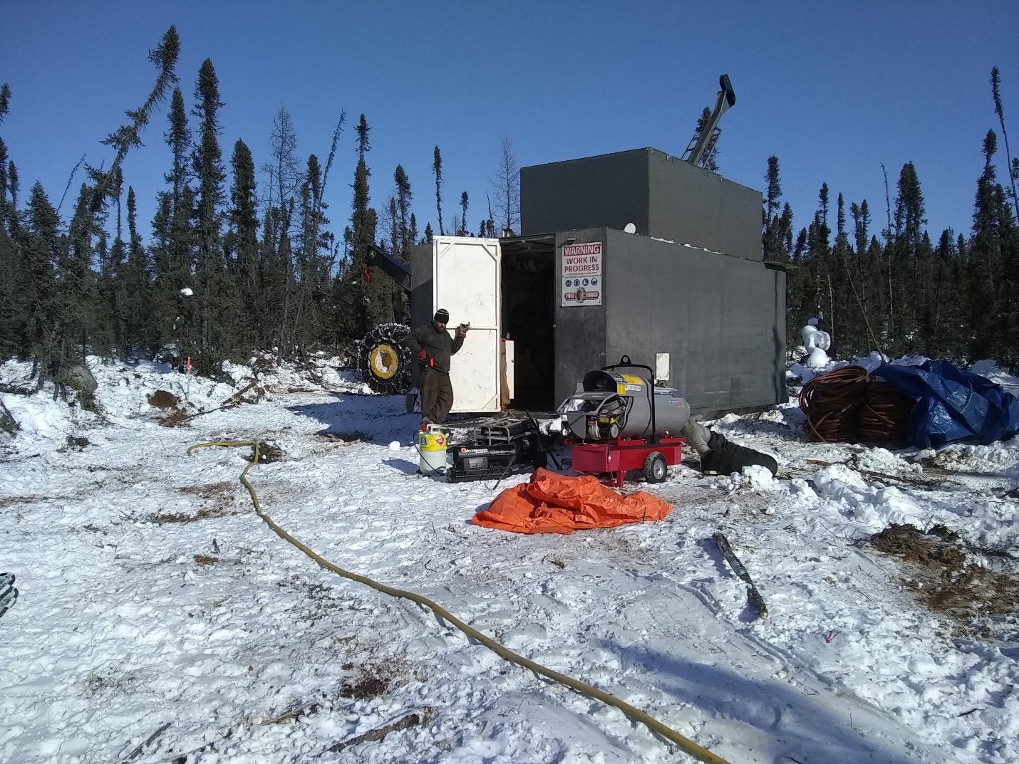
Traction Uranium (CSE:TRAC) has successfully completed the drilling of the first hole in the Phase 1 Diamond Drill Program at its Key Lake South Project in northern Saskatchewan’s Athabasca Basin. The company, in collaboration with UGreenco Energy Corp., is excited to announce the commencement of the second diamond drill hole to explore the “radioactive swamp” discovered during the Fall 2022 exploration program.
The first hole, KLS23-001, was drilled in the logistically most challenging area, farthest from the radioactive swamp. It targeted the edges of the broad gravity low and the “Athabasca Sandstone” mapped from cobble found in the till during the 1970s. Although the company was unable to test the radioactive anomaly during the Fall 2022 Program due to being unable to get above the swamp, they can now do so, as the ground is fully frozen. This has allowed the company to minimize ground impact and mobilize the drill rig to hole KLS23-002, which sits right above the radioactive swamp and will test for uranium mineralization potential beneath the anomaly.
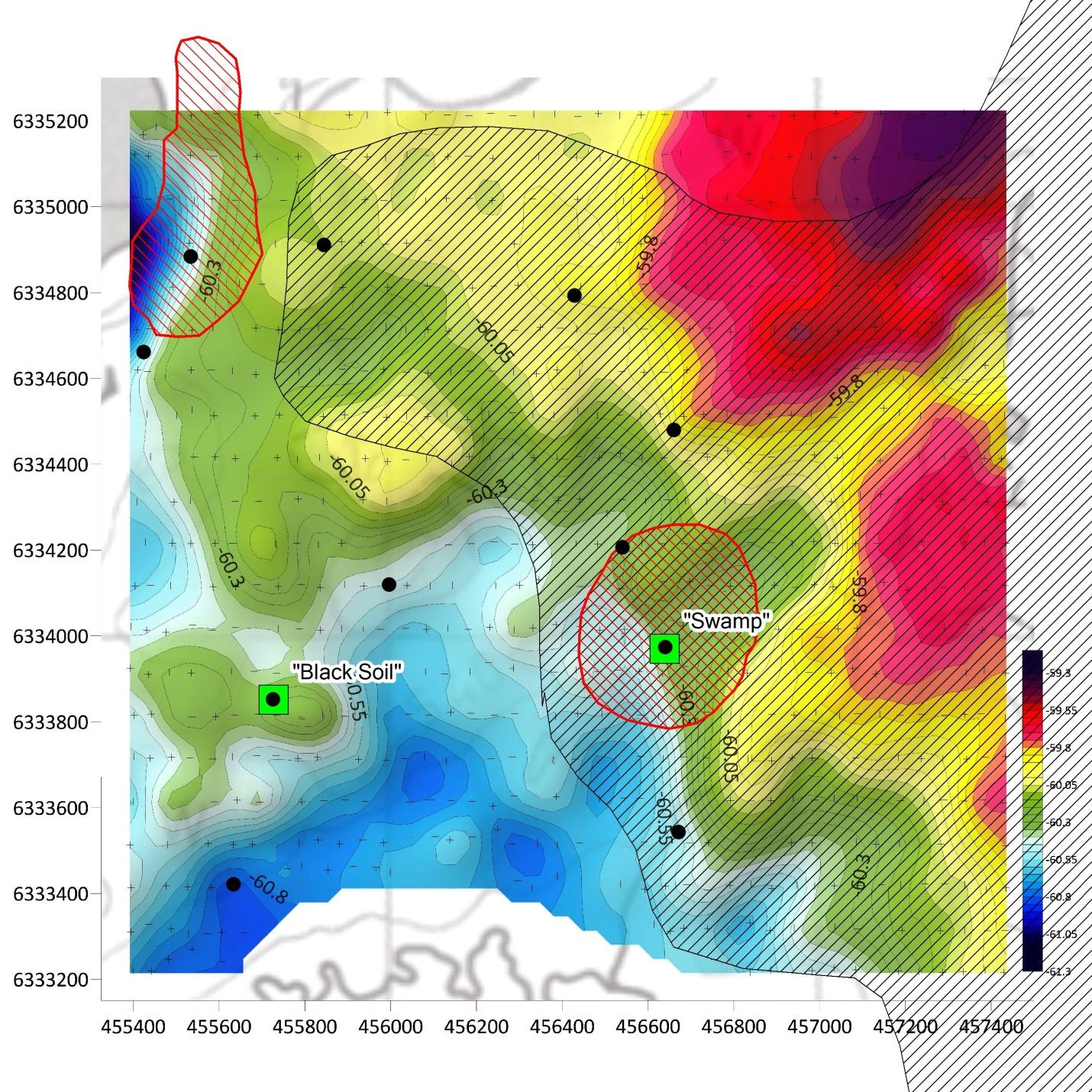
The Phase 1 diamond drilling program is planned for ten high-priority targets, totaling approximately 2,000 meters. Most of the drill targets are located at the edge of the broad gravity-lows identified in the ground gravity survey of 2022 and targeting areas with extreme surface uranium anomalies mapped in 1973, which can be found on Assessment Report # 74H04-001 on the Saskatchewan Mineral Assessment Database (SMAD). The previously unknown radioactive anomalies discovered by Traction’s exploration team during the ground program of 2022 are of particular interest. Sampling of the “black soil,” where the horizon had an observed thickness of approximately 30 centimeters, returned high-grade uranium mineralization in the SRC analysis results.
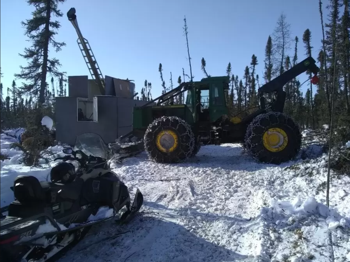
Figure 2. The proposed phase 1 diamond drilling of 2023. Black dots represent proposed drill collars, green squares represent surface radioactive anomalies discovered in the ground program of 2022, red shaded areas represent surface uranium anomalies (uranium content >2.345 ppm) from the airborne gamma-ray spectrometric survey (Ford et al., 2006*) and the black shaded area represents the “Athabasca Sandstone” mapped from cobbles in till in 1973 (referenced from Assessment Report # 74H04-001, (SMAD) Saskatchewan Mineral Assessment Database). Actual location of drill collars may change upon ground conditions in the field.
Furthermore, with the ground presently frozen, the “radioactive swamp” is now accessible, providing another high-priority drill target for the company’s team. The drill crews are currently mobilizing the drill shack to target KLS23-002, and drilling beneath the radioactive swamp will commence this week.
Traction Uranium Corp. is thrilled to make progress in its exploration of the Key Lake South Project and to have the opportunity to explore the radioactive swamp. The company is committed to ensuring minimal ground impact during the drilling process and conducting thorough testing to determine the potential for uranium mineralization.
The above references an opinion and is for information purposes only. It is not intended to be investment advice. Seek a licensed professional for investment advice. The author is not an insider or shareholder of any of the companies mentioned above.
Solaris Resources (TSX:SLS) (OTCQB:SLSSF) has reported new assay results from a series of holes aimed at growing the Northeast Extension of the “Indicative Starter Pit” at the Warintza Project, with further resource expansion growing the area of near-surface, high-grade mineralization estimated at estimated at 180 Mt at 0.82% CuEq¹ (Indicated) and 107 Mt at 0.73% CuEq¹ (Inferred) within the Warintza Mineral Resource Estimate. The company is currently waiting on assays from follow-up step-out drilling, and has additional platforms planned for construction at the project.
Mr. Jorge Fierro, Vice President, Exploration, commented in a press release: “The Northeast Extension represents a significant area of focus for growing the ‘Indicative Starter Pit’, one of the two key goals for the follow-on drilling program from the 2022 MRE, with the other being major resource growth at Warintza East, where extensional and step-out holes are due shortly. In addition, a major program of reconnaissance sampling that commenced last summer has identified new areas of well mineralized outcrop in previously inaccessible terrain adjacent to the Warintza Central and Warintza East deposits that present opportunities for additional discoveries, with further details to be released shortly.”
Highlights from the results are as follows:
- SLS-70 was collared at the northeastern limit of Warintza Central and drilled northeast into an open volume, returning 186m of 0.64% CuEq¹ from near surface within a broader interval of 264m of 0.55% CuEq¹, expanding the zone to the north where it remains open
- This hole follows from SLS-65, drilled approximately 90 degrees to the northwest from the same platform, which returned 286m of 0.55% CuEq¹ from near surface (refer to press release dated December 5, 2022)
- SLS-69, collared from the same platform and drilled the opposite direction to the southwest, returned 156m of 0.60% CuEq¹ from 52m depth within a broader interval of 846m of 0.30% CuEq¹, connecting the Northeast Extension to Warintza Central
- Prior hole SLS-66, drilled west-southwest, returned 124m of 0.82% CuEq¹ from near surface within a broader interval of 622m of 0.42% CuEq¹ (refer to press release dated September 7, 2022) from a platform to the south where a follow-up southwest-oriented hole is planned to better connect the Northeast Extension to Warintza Central
- Assays are pending from two newly constructed 250m step-out platforms testing the zone further to the northeast, with additional platforms planned for construction as the weather improves
Table 1 – Assay Results
| Hole ID | Date Reported | From (m) | To (m) | Interval (m) | Cu (%) | Mo (%) | Au (g/t) | CuEq¹ (%) |
| SLS-70 | Mar 13, 2023 | 26 | 290 | 264 | 0.38 | 0.03 | 0.11 | 0.55 |
| Including | 104 | 290 | 186 | 0.48 | 0.03 | 0.11 | 0.64 | |
| Including | 104 | 198 | 94 | 0.53 | 0.03 | 0.11 | 0.70 | |
| SLS-69 | 52 | 898 | 846 | 0.20 | 0.02 | 0.03 | 0.30 | |
| Including | 52 | 208 | 156 | 0.48 | 0.02 | 0.08 | 0.60 | |
| Including | 52 | 122 | 70 | 0.56 | 0.03 | 0.06 | 0.70 | |
| Notes to table: True widths of the mineralized zone are not known at this time. | ||||||||
Table 2 – Collar Location
| Hole ID | Easting | Northing | Elevation (m) | Depth (m) | Azimuth (degrees) | Dip (degrees) |
| SLS-70 | 800350 | 9648417 | 1356 | 291 | 20 | -65 |
| SLS-69 | 800350 | 9648417 | 1356 | 944 | 200 | -70 |
| Notes to table: The coordinates are in WGS84 17S Datum. | ||||||
Endnotes
- Copper-equivalence calculated as: CuEq (%) = Cu (%) + 4.0476 × Mo (%) + 0.487 × Au (g/t), utilizing metal prices of US$3.50/lb Cu, US$15.00/lb Mo, and US$1,500/oz Au, and assumes recoveries of 90% Cu, 85% Mo, and 70% Au based on preliminary metallurgical test work. The ‘Indicative Starter Pit’ is based on the same assumptions as the MRE except utilized metal prices of US$1.00/lb Cu, US$7.50/lb Mo, and US$750/oz Au. The ‘Indicative Starter Pit’ is comprised of Indicated mineral resources of 180 Mt at 0.82% CuEq (0.67% Cu, 0.03% Mo, 0.07 g/t Au) and Inferred mineral resources of 107 Mt at 0.73% CuEq (0.64% Cu, 0.02% Mo, 0.05 g/t Au) above a 0.6% CuEq cut-off grade. No economic analysis has been completed by the Company and there is no guarantee an ‘Indicative Starter Pit’ will be realized or prove to be economic.
- Refer to Solaris’ technical report titled, “NI 43-101 Technical Report for the Warintza Project, Ecuador” with an effective date of April 1, 2022, prepared by Mario E. Rossi and filed on the Company’s SEDAR profile at www.sedar.com.
- For additional details on “Near Surface, High-Grade, NE Extension” intervals, refer to press release dated May 26, 2022 for SLS-57: 230m of 0.73% CuEq (0.59% Cu, 0.03% Mo, 0.08 g/t Au), refer to press release dated July 20, 2022 for SLS-62: 168m of 0.68% CuEq (0.51% Cu, 0.03% Mo, 0.07 g/t Au) and SLS-63: 230m of 1.02% CuEq (0.87% Cu, 0.02% Mo, 0.12 g/t Au), refer to press release dated September 7, 2022 for SLS-64: 110m of 0.54% CuEq (0.38% Cu, 0.04% Mo, 0.03 g/t Au) and SLS-66: 124m of 0.82% CuEq (0.71% Cu, 0.02% Mo, 0.09 g/t Au), refer to press release dated December 5, 2022 for SLS-65: 286m of 0.55% CuEq (0.38% Cu, 0.04% Mo, 0.06 g/t Au) and SLS-68: 72m of 1.00% CuEq (0.88% Cu, 0.02% Mo, 0.06 g/t Au).
The above references an opinion and is for information purposes only. It is not intended to be investment advice. Seek a licensed professional for investment advice. The author is not an insider or shareholder of any of the companies mentioned above.
GoGold Resources (TSX:GGD) has announced the latest drilling results from the Eagle and Main Deposits at Los Ricos South, with Hole LRGAG-22-125 intercepting 42.3m of 288 g/t silver equivalent, containing 2,017 g/t AgEq over 2.8m. The results are consistent with geophysical targets on the new concession, and drilling at the Eagle has returned the highest grade intercepts to date in the district.
The Eagle Deposit adjoins the Main Deposit and represents a northern extension of the previously defined Mineral Resource Estimate in the Los Ricos South PEA. The Eagle concession covers 1,107 hectares, including the area between the Main Deposit and the Company’s Jamaica concession located 3km to the northwest, where the Company holds the rights to additional concessions.
The LRGG holes contained in the results in Table 1 are part of a new drilling program at the Main Deposit. The aim of the program is to better define the very high-grade portions of the current deposit that may be amenable to bulk underground mining. The Company is carrying out a trade-off study to better define what portion of the deposit could be mined in a lower strip ratio pit and what portion would best be mined in more selective bulk underground mining.
Table 1: Drill Hole Intersections
| Hole ID | Area / Vein | From | To | Length1 | Au | Ag | AuEq2 | AgEq2 |
| (m) | (m) | (m) | (g/t) | (g/t) | (g/t) | (g/t) | ||
| LRGAG-22-116 | Eagle | 57.6 | 72.3 | 14.7 | 1.45 | 68.9 | 2.37 | 177.6 |
| including | 57.6 | 62.6 | 5.0 | 2.56 | 162.0 | 4.72 | 353.9 | |
| including | 58.6 | 59.6 | 1.0 | 5.18 | 257.0 | 8.61 | 645.5 | |
| LRGAG-22-117 | Eagle | 64.5 | 89.5 | 25.0 | 1.09 | 133.1 | 2.87 | 214.9 |
| including | 65.5 | 74.5 | 9.0 | 1.96 | 306.8 | 6.06 | 454.1 | |
| including | 65.5 | 66.5 | 1.0 | 8.08 | 1,460.0 | 27.55 | 2,066.0 | |
| LRGAG-22-119 | Eagle | 162.0 | 174.5 | 12.5 | 0.89 | 81.5 | 1.98 | 148.3 |
| including | 186.0 | 187.4 | 1.4 | 2.77 | 321.0 | 7.05 | 529.1 | |
| LRGAG-22-120 | Eagle | 229.0 | 242.3 | 13.4 | 1.44 | 44.9 | 2.04 | 152.7 |
| including | 239.2 | 240.3 | 1.2 | 9.92 | 119.7 | 11.52 | 863.9 | |
| LRGAG-22-122 | Eagle | 203.7 | 216.0 | 12.4 | 1.54 | 28.2 | 1.91 | 143.6 |
| including | 205.1 | 207.3 | 2.2 | 6.05 | 45.6 | 6.65 | 499.0 | |
| LRGAG-22-124 | Eagle | 128.7 | 130.7 | 2.0 | 2.07 | 95.1 | 3.33 | 250.1 |
| and | 140.2 | 142.6 | 2.4 | 7.05 | 56.3 | 7.80 | 584.9 | |
| including | 141.0 | 141.9 | 0.8 | 14.35 | 66.0 | 15.23 | 1,142.3 | |
| LRGAG-22-125 | Eagle | 127.9 | 170.2 | 42.3 | 2.14 | 127.9 | 3.84 | 288.3 |
| including | 153.9 | 161.3 | 7.3 | 9.66 | 485.8 | 16.13 | 1,210.0 | |
| including | 153.9 | 156.7 | 2.8 | 15.35 | 865.7 | 26.89 | 2,016.8 | |
| LRGG-22-228 | Main Area | 235.7 | 251.5 | 11.9 | 1.30 | 120.1 | 2.90 | 217.5 |
| LRGG-22-231 | Main Area | 30.0 | 32.0 | 2.0 | 0.59 | 95.3 | 1.86 | 139.8 |
| LRGG-22-232 | Main Area | 112.6 | 122.8 | 10.2 | 2.60 | 60.9 | 3.41 | 255.7 |
| including | 113.4 | 114.2 | 0.8 | 24.60 | 238.0 | 27.77 | 2,083.0 | |
| LRGG-22-233 | Main Area | 280.2 | 299.0 | 18.9 | 0.51 | 78.2 | 1.56 | 116.7 |
| including | 281.1 | 282.0 | 0.9 | 1.84 | 400.0 | 7.17 | 538.0 |
| 1. | Not true width |
| 2. | AgEq converted using a silver to gold ratio of 75:1 at recoveries of 100% |
| 3. | Holes LRGG-22-121, LRGG-22-229 and LRGG-22-230 did not intercept significant mineralization |
| 4. | Hole LRGG-22-123 was abandoned due to technical difficulties |
These holes are in addition to those drilled in 2019 and 2020 which formed part of the initial resource upon which the Los Ricos South Preliminary Economic Assessment (“PEA”) was based upon when it was released on January 20, 2021.
Overall, the results are a positive indication of the mineral potential in the Los Ricos district, and the Company is confident that further exploration will yield significant results.
Brad Langille, President and CEO of GoGold, commented in a press release: “We continue to see strong results from our drilling program at Los Ricos South, such as those from hole 125 which expands on the high-grade area shown in Figure 1. It is drilling results such as these which we anticipate will provide a very positive impact when our Mineral Resource Estimate and Preliminary Economic Assessment at Los Ricos South is updated later this year. “
Table 2 : Eagle Deposit Drill Intercept Highlights
| Hole ID | Area / Vein | From | To | Length1 | Au | Ag | AuEq2 | AgEq2 |
| (m) | (m) | (m) | (g/t) | (g/t) | (g/t) | (g/t) | ||
| LRGAG-22-118 | Eagle | 95.6 | 150.6 | 55.0 | 7.80 | 2,152.7 | 36.51 | 2,737.9 |
| including | 95.6 | 120.6 | 25.0 | 16.07 | 4,664.2 | 78.26 | 5,869.3 | |
| including | 104.6 | 119.6 | 15.0 | 26.74 | 7,755.8 | 130.15 | 9,761.3 | |
| including | 107.6 | 114.6 | 7.0 | 55.87 | 16,524.6 | 276.19 | 20,714.5 | |
| including | 107.6 | 110.6 | 3.0 | 121.97 | 36,953.0 | 614.67 | 46,100.5 | |
| including | 108.6 | 110.6 | 2.0 | 145.25 | 52,764.5 | 848.78 | 63,658.3 | |
| LRGAG-22-035 | Eagle | 69.0 | 179.6 | 110.6 | 1.64 | 264.6 | 5.17 | 387.5 |
| including | 129.0 | 140.5 | 11.5 | 11.31 | 2,198.3 | 40.62 | 3,046.7 | |
| including | 130.4 | 133.8 | 3.5 | 30.24 | 6,392.5 | 115.48 | 8,660.8 | |
| including | 130.4 | 131.9 | 1.5 | 63.24 | 12,729.3 | 232.96 | 17,472.0 | |
| including | 131.0 | 131.9 | 0.9 | 104.50 | 13,742.5 | 287.73 | 21,580.0 | |
| LRGAG-21-014 | Eagle | 144.3 | 216.9 | 72.6 | 5.13 | 76.0 | 6.14 | 460.6 |
| including | 198.8 | 210.7 | 11.9 | 28.58 | 115.9 | 30.13 | 2,259.8 | |
| including | 208.6 | 210.7 | 2.1 | 146.03 | 176.8 | 148.39 | 11,128.9 | |
| including | 208.6 | 209.3 | 0.7 | 266.00 | 319.0 | 270.25 | 20,269.0 | |
| LRGAG-22-031 | Eagle | 58.0 | 126.0 | 68.0 | 4.25 | 109.4 | 5.71 | 428.4 |
| including | 78.0 | 113.9 | 35.9 | 7.83 | 184.9 | 10.29 | 771.8 | |
| including | 80.0 | 95.0 | 15.0 | 15.61 | 273.3 | 19.26 | 1,444.4 | |
| including | 84.0 | 86.0 | 2.0 | 46.80 | 272.5 | 50.43 | 3,782.5 | |
| LRGAG-22-032 | Eagle | 48.1 | 113.8 | 65.8 | 1.36 | 107.7 | 2.79 | 209.6 |
| including | 85.8 | 113.8 | 28.1 | 2.96 | 216.6 | 5.85 | 439.0 | |
| including | 88.5 | 92.9 | 4.3 | 7.17 | 1,012.8 | 20.68 | 1,550.7 | |
| including | 88.5 | 89.1 | 0.6 | 25.00 | 3,020.0 | 65.27 | 4,895.0 | |
| LRGAG-22-041 | Eagle | 109.5 | 145.5 | 36.0 | 1.46 | 134.5 | 3.26 | 244.3 |
| including | 134.0 | 143.5 | 9.5 | 4.55 | 389.9 | 9.75 | 731.1 | |
| including | 134.0 | 134.8 | 0.8 | 6.01 | 577.0 | 13.70 | 1,027.7 | |
| also including | 137.0 | 143.5 | 6.6 | 5.62 | 453.6 | 11.67 | 875.3 | |
| including | 141.0 | 142.2 | 1.2 | 17.10 | 1,345.0 | 35.03 | 2,627.5 | |
| LRGAG-22-113 | Eagle | 132.8 | 149.0 | 16.3 | 3.29 | 357.7 | 8.06 | 604.8 |
| including | 133.8 | 135.6 | 1.8 | 20.05 | 2,000.0 | 46.72 | 3,503.7 | |
| including | 134.8 | 135.6 | 0.8 | 40.00 | 3,490.0 | 86.53 | 6,490.0 | |
| and | 160.5 | 190.0 | 29.5 | 2.32 | 57.8 | 3.09 | 231.7 | |
| including | 165.1 | 177.4 | 12.3 | 5.20 | 72.1 | 6.16 | 462.4 | |
| including | 169.0 | 170.0 | 1.0 | 21.10 | 170.0 | 23.37 | 1,752.5 | |
| LRGAG-21-018 | Eagle | 127.6 | 163.0 | 33.6 | 1.57 | 85.5 | 2.71 | 203.5 |
| including | 156.9 | 159.3 | 2.4 | 10.51 | 436.5 | 16.33 | 1,225.0 | |
| including | 156.9 | 157.6 | 0.8 | 15.00 | 1,155.0 | 30.40 | 2,280.0 | |
| and | 177.9 | 178.6 | 0.7 | 36.20 | 1,500.0 | 56.20 | 4,215.0 | |
| LRGAG-22-030 | Eagle | 42.9 | 79.5 | 36.7 | 1.77 | 156.2 | 3.85 | 289.0 |
| including | 51.9 | 61.0 | 9.1 | 6.00 | 553.3 | 13.38 | 1,003.2 | |
| including | 54.1 | 54.8 | 0.7 | 14.00 | 1,260.0 | 30.80 | 2,310.0 | |
| LRGAG-22-029 | Eagle | 74.0 | 94.6 | 20.6 | 1.52 | 217.5 | 4.42 | 331.3 |
| including | 75.5 | 77.5 | 2.0 | 8.00 | 1,865.5 | 32.87 | 2,465.5 | |
| including | 75.5 | 76.5 | 1.0 | 14.15 | 3,520.0 | 61.08 | 4,581.3 | |
| LRGAG-21-007 | Eagle | 148.5 | 191.0 | 42.5 | 1.64 | 137.5 | 3.47 | 260.6 |
| including | 188.6 | 190.2 | 1.6 | 6.83 | 1,269.5 | 23.76 | 1,781.8 |
Table 3: Drill Hole Locations
| Hole ID | Easting | Northing | Elevation | Azimuth | Dip | Length |
| LRGAG-22-116 | 610068 | 2328476 | 1277 | 50 | -45 | 127 |
| LRGAG-22-117 | 610067 | 2328475 | 1277 | 50 | -70 | 146 |
| LRGAG-22-118 | 610066 | 2328475 | 1277 | 0 | -90 | 181 |
| LRGAG-22-119 | 610050 | 2328304 | 1283 | 50 | -63 | 256 |
| LRGAG-22-120 | 610014 | 2328144 | 1319 | 50 | -68 | 297 |
| LRGAG-22-121 | 610141 | 2328156 | 1329 | 50 | -56 | 234 |
| LRGAG-22-122 | 609993 | 2328421 | 1259 | 50 | -77 | 253 |
| LRGAG-22-123 | 610141 | 2328185 | 1325 | 50 | -60 | 173 |
| LRGAG-22-124 | 610057 | 2328341 | 1282 | 50 | -61 | 202 |
| LRGAG-22-125 | 609956 | 2328624 | 1267 | 50 | -78 | 210 |
| LRGG-22-228 | 610432 | 2327584 | 1263 | 50 | -53 | 270 |
| LRGG-22-229 | 610243 | 2327712 | 1236 | 50 | -56 | 164 |
| LRGG-22-230 | 610337 | 2327788 | 1256 | 50 | -60 | 190 |
| LRGG-22-231 | 610312 | 2328038 | 1299 | 50 | -44 | 77 |
| LRGG-22-232 | 610384 | 2327771 | 1264 | 50 | -45 | 150 |
| LRGG-22-233 | 610396 | 2327552 | 1251 | 50 | -55 | 305 |
The above references an opinion and is for information purposes only. It is not intended to be investment advice. Seek a licensed professional for investment advice. The author is not an insider or shareholder of any of the companies mentioned above.
Rock Tech Lithium (TSXV:RCK) has announced that the first diamond drill rig for the first phase of its 2023 exploration drill campaign has been mobilized at the 100%-owned Georgia Lake Lithium project in the Thunder Bay Mining District, Ontario. The aim of the program is to increase the total mineral resources at the project between 2023 and 2024. Phase I will include the mobilization of a drill rig for the 3,500-metre program, with targeted drilling aimed at expanding the existing Spodumene mineralization at the Main Zone North (MZN) and McVittie Deposits.
MZN contains the largest Mineral Resource in the Georgia Lake Pegmatite Field, and it currently remains open along strike to the east. Drilling will aim to extend the Spodumene mineralization along strike to the east of MZN. Step-out drilling south of the MZN deposit will focus on extending mineralization where Rock Tech has already identified new mineralization throughout the course of the 2022 drilling program.
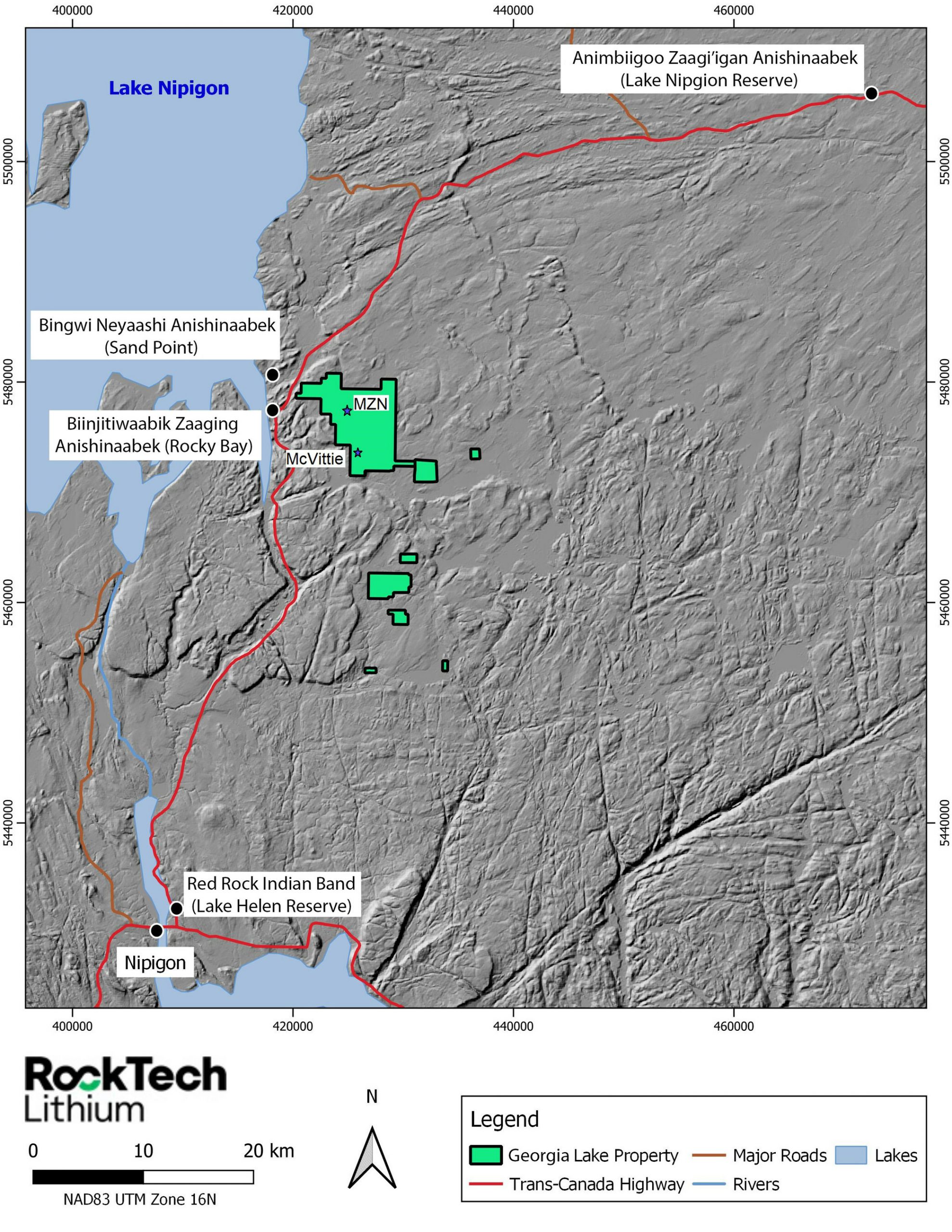
McVittie is comprised of three spodumene dikes; these have been mapped for a strike length of more than 600m. Inferred Resource at the deposit is 1Mt at 1.0% Li2O and is open at depth and along strike in both directions. Rock Tech also reported a Mineral Resource Estimate at the Georgia Lake Prefeasbility Study, outlining 10,60 million tonnes of Indicated Mineral Resource at a grade of 0.88% Li2O and 4.22 mt of Inferred Mineral Resource at a grade of 1.0% Li2O limited to eight deposits in the Northern and Southern Spodumene Pegmatite Areas.
Dirk Harbecke, Rock Tech’s Chief Executive, commented in a press release: “It is our aim for 2023 to unlock the exploration potential of our Georgia Lake Project by advancing our drilling and prospecting activities across the land package. We are pleased to be able to initiate a drill program which we believe will grow our MZN and McVittie deposits as the first phase of our 2023 exploration campaign. I expect that our exploration program will lead to a sizeable increase of our Resource over the next year.”
TABLE 1 | Overview of the Mineral Resource as of 2022’s Prefeasibility Study
2022 MINERAL RESOURCE
| Classification | Mining | Cut-off grade Li2O (%) | Zone | Tonnes | Li2O (%) |
| Indicated | Open pit | 0.3 | NSPA OP Indicated | 4,242,618 | 0.88 |
| Indicated | Underground | 0.6 | NSPA UG Indicated | 6,358,650 | 0.89 |
| Total Indicated | 10,601,268 | 0.88 | |||
| Inferred | Open pit | 0.3 | NSPA OP Inferred | 245,933 | 0.78 |
| Inferred | Underground | 0.6 | NSPA UG Inferred | 2,073,069 | 0.91 |
| Inferred | Underground | 0.6 | SSPA UG Inferred | 1,903,274 | 1.12 |
| Total Inferred | 4,222,276 | 1.00 |
| Notes: |
| a. CIM Definition Standards (2014) were used for reporting the Mineral Resources. |
| b. The Qualified Person is Dinara Nussipakynova, P.Geo. of AMC. |
| c. Cut-off grade for open pit Mineral Resources is 0.30% Li2O. |
| d. Open pit Mineral Resources are constrained by the optimization pits shell at a lithium concentrate price of USD 1,100/t with metallurgical recovery of 80% and concentrate grade of 6%. Both cut off use same parameters. |
| e. The pit optimization was based on following cost assumptions: |
| i. Mill feed mining costs of USD 4.5/t and waste mining cost of USD 4.5/t. |
| ii. Processing costs of USD 25/t and General and Administration costs of USD 15/t. |
| iii. Slope angle 45-48 degrees. |
| f. Cut-off grade for underground Mineral Resources is 0.60% Li2O based on a USD 45/t mining cost and processing and G&A the same as the open pit. |
| g. Underground Mineral Resources are not constrained. |
| h. Mineralized Density used as 2.69 t/m3. |
| i. Waste Density used as 2.75 t/m3. |
| j. Drilling results up to 31 July 2022. |
| k. The numbers may not compute exactly due to rounding. |
| j. Numbers may not compute exactly due to rounding. |
The above references an opinion and is for information purposes only. It is not intended to be investment advice. Seek a licensed professional for investment advice. The author is not an insider or shareholder of any of the companies mentioned above.
Rockcliff Metals (CSE:RCLF) has provided an update from its completed drill program at the Bur property in Manitoba. The company completed drilling to test potential copper-zinc geophysical targets and found multiple pegmatite dykes in drill core near its existing high-grade Bur VMS Deposit with thicknesses of up to roughly 15 metres.
Located within the Flin Flon Snow Lake Greenstone Belt, the Bur Property is known for its high-grade copper-zinc potential and is recognized as part of the lithium-bearing Wekusko Lake Pegmatite Field east of Snow Lake, Manitoba.
The Wekusko Lake Pegmatite Field hosts several nearby historical lithium-rich pegmatite deposits and other exploration completed by other companies yielded discoveries of lithium-bearing pegmatites in the area. This has created a spike in interest in the area due to the current increase in global demand for critical minerals.
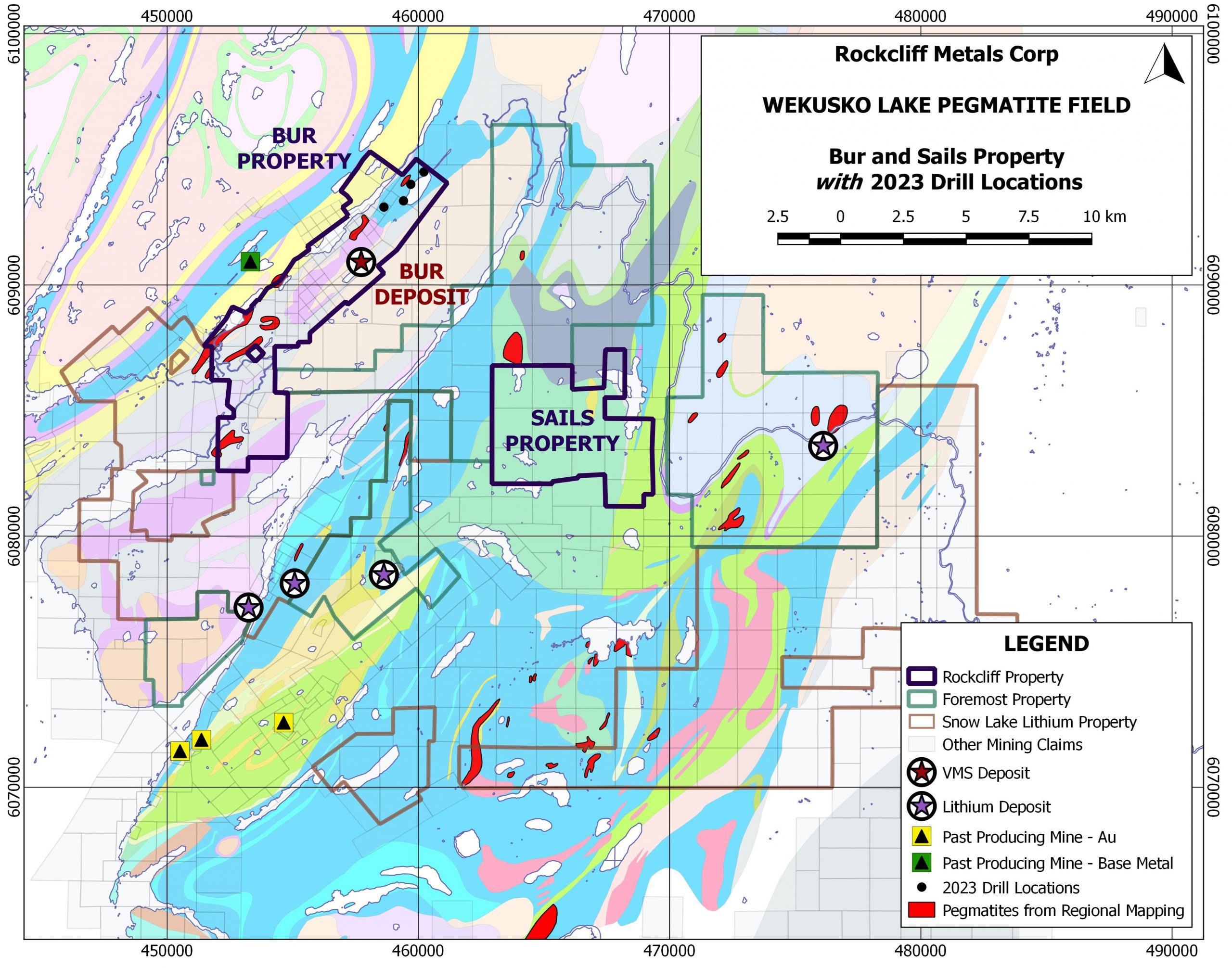
Rockcliff’s interim President and CEO, Ken Lapierre, commented in a press release: “Our drill program at Bur has discovered the presence of beryl, tourmaline and lithium bearing spodumene and lepidolite in zoned pegmatites within the WLPF. The discovery of pegmatites near our existing 5.3 million tonne high grade Bur VMS Deposit is truly a testament to the tremendous prospectivity of the property for copper, zinc and now lithium and other critical minerals. Historical maps on the property have outlined kilometres long unexplored pegmatite dyke swarms at surface throughout the property. A modern-day staking rush continues around us and heated interest in this area focuses on its potential to host multiple and significant areas with lithium and critical minerals all near a world class copper-zinc mining camp with excellent infrastructure already in place. As we continue to focus on copper and zinc within our extensive property portfolio, we will sample and assay lithium and critical minerals on all pegmatites intersected in our drilling at the Bur Property. We will also re-examine Bur historical drill core for additional pegmatite intersections previously not recognized. Rockcliff plans to expand its summer prospecting program at Bur and at its nearby 100% owned Sails Property, which happens to be centered between two major landowners in the WLPF. It’s in the early stages for us in the lithium space but we are excited to investigate this tremendous lithium and critical mineral opportunity and will keep our shareholders updated with results.”
Highlights from the results are as follows:
Bur Property: Bur VMS Deposit and Wekusko Lake Pegmatite Field (see Figure 1)
A total of approximately 1,400 metres of drilling in 4 holes were completed on geophysical targets within the hangingwall and footwall rocks hosting the Bur VMS Deposit. All targets were explained by the presence of appreciable graphite and pyrite and all mineralized areas will be assayed for copper and zinc.
Additionally, multiple pegmatite dykes have been discovered by drilling on the Bur property across an area of approximately 2 kilometres. The Bur Property is now recognized as being part of the WLPG, which represents a well-endowed belt of lithium bearing pegmatites east of the main Snow Lake mining camp. All 4 holes intersected from one up to 5 pegmatite dykes ranging from down the hole thicknesses (not true thickness) of 0.5 metres and up to 14.82 metres. Historical mapping at the Bur Property have identified numerous unexplored pegmatite dyke swarms at surface. If drill core sampling of the pegmatite dykes proves successful, Rockcliff will expand its efforts to determine the prospectivity of the pegmatite dykes throughout the Bur Property in the coming spring and summer seasons. Rockcliff will also compile all existing data at our 100% owned Sail Property that is in the center of the WLPF.
The 100% owned Bur Property hosts the Bur VMS Deposit and is located approximately 30 kilometres by gravel and paved road from the center of the Snow Lake Mining Camp. The Bur VMS Deposit is a strategic, high-grade and significant resource of copper and zinc. It remains open at depth and along strike. (see Figure 2 below).
Bur VMS Deposit
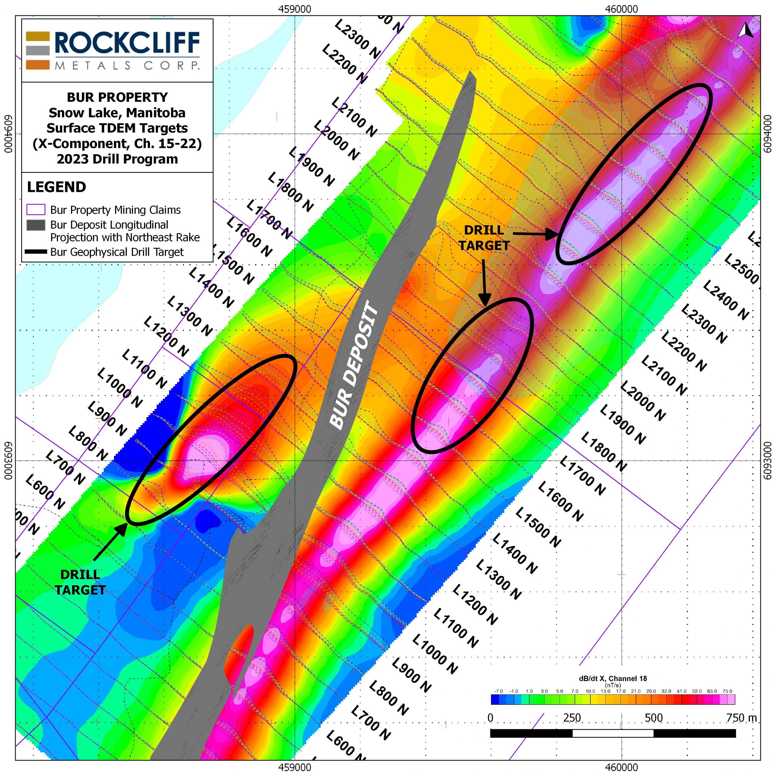
Rockcliff completed a NI 43-101 Technical Report in Q4 2021 on the Bur Property and press released the report on November 22, 2021. The Technical Report prepared by Stantec, with an effective date of October 26, 2021, is summarized below:
Bur VMS Deposit Mineral Resource Estimate at a 2.3% CuEq Cut-Off Grade (1-12)
| Classification | Tonnes
(k) |
Cu
(%) |
Zn
(%) |
Au
(g/t) |
Ag
(g/t) |
CuEq
(%) |
Cu
(Mlbs) |
Zn
(Mlbs) |
Au
(koz) |
Ag
(koz) |
CuEq
(Mlbs) |
| Measured | 338 | 1.54 | 3.58 | 0.05 | 12.94 | 2.87 | 11.48 | 26.68 | 0.54 | 140.62 | 21.39 |
| Indicated | 2,679 | 1.70 | 6.45 | 0.02 | 3.41 | 3.97 | 100.41 | 380.95 | 1.72 | 293.71 | 234.48 |
| Measured/Indicated | 3,017 | 1.69 | 6.13 | 0.02 | 4.48 | 3.84 | 112.37 | 407.59 | 1.94 | 434.41 | 255.33 |
| Inferred | 2.342 | 1.03 | 8.65 | 0.00 | 0.91 | 4.04 | 53.18 | 446.62 | 0.00 | 68.52 | 208.59 |
- CIM definitions are followed for classification of Mineral Resource.
- Mineral resources are contained within a mineralized vein (zone) dipping at approximately 60 degrees towards the northwest whose closest vertical depth from surface is 6 m and maximum vertical depth is 1,274 m.
- Resources are constrained to a minimum true vein thickness of 0.2 m and where calculated block revenues after recovery are greater than costs for mining.
- CuEq (%) = Cu (%) + Zn (%) x 0.347 + Au(gpt) x 0.430 +Ag(gpt) x 0.005
- ZnEq (%) = Cu (%) x 2.885 + Zn (%) + Au(gpt) x 1.241 + Ag(gpt) x 0.016
- CuEq and ZnEq formulas are calculated using the following revenue inputs: Cu US$ 3.26/lb, Zn US$ 1.13/lb, Au US$ 1,744/oz, and Ag US$ 22.05/oz. Metal recoveries are: 80% Cu, 80% Zn, 40% Au and 40% Ag.
- Mining costs used to determine prospects for eventual economic extraction total C$110/t.
- US$ to C$ exchange rate applied is 1:1.31.
- Specific gravity for the mineralized zone is fixed at 3.1.
- Totals may not represent the sum of the parts due to rounding.
- The Mineral Resource estimate has been prepared by Derek Loveday, P. Geo. of Stantec Consulting Services Ltd. in conformity with CIM “Estimation of Mineral Resource and Mineral Reserves Best Practices” guidelines and are reported in accordance with the Canadian Securities Administrators NI 43-101. Mineral resources are not mineral reserves and do not have demonstrated economic viability. There is no certainty that any mineral resource will be converted into mineral reserve.
- The 100% owned Bur Property is part of the Company’s extensive Manitoba property portfolio, has excellent infrastructure with a year-round access road, clearing for portable buildings, and a box cut and portal. The Bur Property lies within the Flin Flon-Snow Lake greenstone belt, the largest Paleoproterozoic VMS district in the world and the most prolific VMS district in Canada.
The above references an opinion and is for information purposes only. It is not intended to be investment advice. Seek a licensed professional for investment advice. The author is not an insider or shareholder of any of the companies mentioned above.
Orezone Gold (TSX:ORE), a Canadian gold exploration and development company, has announced the latest results of its Phase III resource definition drill program at the Bomboré Gold Mine in Burkina Faso. The program has focused on expanding the P17 zone and converting Inferred Resources into Measured and Indicated, in preparation for the upcoming sulphide expansion study.
The company’s Phase III program has yielded positive results, with the latest diamond drill results from the P8P9 and Maga zones contributing to over 100,000 meters of additional drilling to be incorporated into the upcoming resource and reserve update and expansion study.
According to Orezone, this marks the final set of Phase III drill results, bringing the company one step closer to achieving its goal of expanding the P17 zone and converting Inferred Resources to Measured and Indicated. The successful completion of this phase is a significant milestone in the company’s ongoing efforts to develop the Bomboré Gold Mine into a world-class mining operation.
Patrick Downey, President and CEO commented in a press release: “Our 2022 resource definition and expansion drill program has exceeded expectations, with several new high-grade zones now well-defined, all of which remain open to further expansion. The most recent results from P8P9 have delineated a new thick, well-mineralized zone, with several high-grade intercepts over downhole widths ranging from 20m to 50m. This zone remains open in several directions including towards surface. All sulphide drill results have now been received and the resource update, which will incorporate over 100,000m of new drilling, is now well-advanced. The sulphide expansion study will provide the platform to significantly increase annual throughput and production at the Bomboré operation and is expected to be released in Q3-2023.”
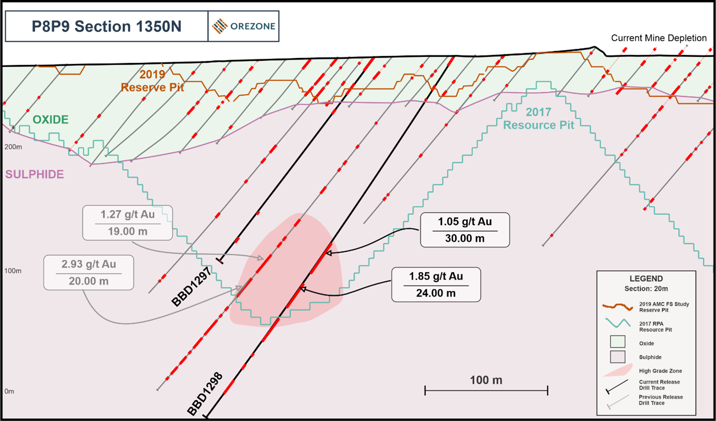
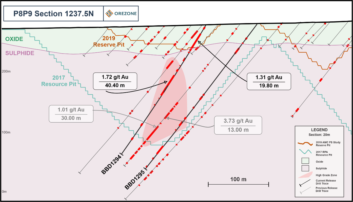
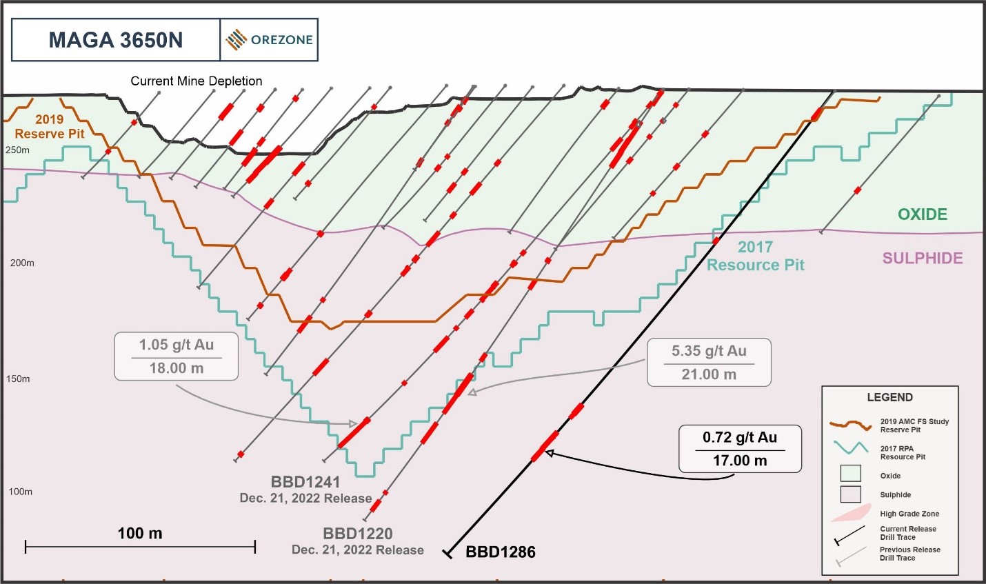
Highlights from the results are as follows:
- Delineation drilling at P8P9 revealed a higher-grade zone of plunging mineralization. To date, this zone has been traced over 150m along strike, and remains open at depth and towards surface. The higher-grade zone is similar to that observed in the emerging high-grade P17 zone located 8km to the south as it is associated with, and/or in proximity to, a granodiorite intrusion. Several intercepts at P8P9 returned thick well-mineralized intervals.
- Phase III drilling at P8P9 was successful in further illustrating the continuity of mineralization below the current shallow reserve pit, with mineralization locally traced to a depth of ~250m below surface.
- Additional drilling at Maga continued to return several high-grade intercepts in the sulphide zone, further illustrating down-dip continuity. These results follow the more extensive set of Maga drill results released on December 21, 2022.
- Still outstanding from the Phase III drill program are the RC oxide drill results, which are expected to be released in the coming weeks.
P8P9 Drilling Highlights:
- 1.72 g/t Au over 40.40m from 99.00m, including 4.31 g/t Au over 8.25m from 126.75m in hole BBD1294
- 1.49 g/t Au over 53.70m from 39.30m in hole BBD1305, including 13.00m @2.01 g/t from 57.00m
- 1.05 g/t Au over 30.00m from 182.00m and a further 1.85 g/t Au over 24.00m from 222.00m in hole BBD1298, including 2.88 g/t Au over 11.00m from 225.00m
- 1.06 g/t Au over 44.00m from 260.00m in hole BBD1312, including 2.75 g/t Au over 8.00m from 271.00m
- 1.16 g/t Au over 21.00m from 83.00m in hole BBD1288
- 2.08 g/t Au over 10.30m from 170.50m in hole BBD1289
- 1.98 g/t Au over 11.70m from 31.80m in hole BBD1309, including 4.59 g/t Au over 4.50m from 39.00m
- 1.37 g/t Au over 14.40m from 166.00m in hole BBD1293
Maga Drilling Highlights:
- 5.59 g/t Au over 15.00m from 221.00m in hole BBD1287, including 62.21 g/t Au over 4.50m from 225.00m
- 3.14 g/t Au over 18.00m from 197.00m in hole BBD1285
- 9.78 g/t Au over 2.00m from 208.00m in hole BBD1283
- 10.83 g/t Au over 2.00m from 303.00m in hole BBD1283
Table 1: P8P9 Highlight Drill Results
| Hole # | From (m) | To (m) | Length (m)* | Grade (g/t gold) |
| BBD1264 | 102.50 | 107.00 | 4.50 | 3.47 |
| and | 147.35 | 148.20 | 0.85 | 66.36 |
| BBD1265 | 122.80 | 125.50 | 2.70 | 4.21 |
| BBD1267 | 86.70 | 106.00 | 19.30 | 0.60 |
| and | 115.00 | 131.00 | 16.00 | 0.88 |
| BBD1268 | 65.00 | 77.00 | 12.00 | 1.33 |
| incl. | 71.00 | 72.00 | 1.00 | 9.64 |
| and | 209.00 | 212.00 | 3.00 | 5.21 |
| BBD1279 | 113.00 | 127.00 | 14.00 | 1.37 |
| incl. | 121.00 | 123.15 | 2.15 | 4.46 |
| BBD1288 | 83.00 | 104.00 | 21.00 | 1.16 |
| and | 109.60 | 141.00 | 31.40 | 0.80 |
| incl. | 138.00 | 140.00 | 2.00 | 3.10 |
| and | 223.40 | 233.00 | 9.60 | 1.28 |
| BBD1289 | 170.50 | 180.80 | 10.30 | 2.08 |
| and | 191.00 | 193.00 | 2.00 | 6.17 |
| BBD1290 | 7.80 | 26.00 | 18.20 | 0.86 |
| and | 109.20 | 126.75 | 17.55 | 1.59 |
| incl. | 125.00 | 126.75 | 1.75 | 8.46 |
| BBD1293 | 63.10 | 84.00 | 20.90 | 0.90 |
| incl. | 72.00 | 73.00 | 1.00 | 6.18 |
| and | 166.00 | 180.40 | 14.40 | 1.37 |
| BBD1294 | 17.40 | 51.00 | 33.60 | 0.98 |
| incl. | 20.20 | 40.00 | 19.80 | 1.31 |
| and | 99.00 | 139.40 | 40.40 | 1.72 |
| incl. | 126.75 | 136.00 | 8.25 | 4.31 |
| and | 144.60 | 145.60 | 1.00 | 12.81 |
| and | 157.00 | 159.00 | 2.00 | 14.23 |
| BBD1295 | 257.00 | 274.00 | 17.00 | 0.64 |
| BBD1298 | 182.00 | 212.00 | 30.00 | 1.05 |
| incl. | 188.00 | 189.00 | 1.00 | 9.38 |
| and | 222.00 | 246.00 | 24.00 | 1.85 |
| incl. | 225.00 | 236.00 | 11.00 | 2.88 |
| and | 257.00 | 280.00 | 23.00 | 0.59 |
| BBD1300 | 0.50 | 8.80 | 8.30 | 1.77 |
| incl. | 4.10 | 5.40 | 1.30 | 6.66 |
| BBD1301 | 85.00 | 101.00 | 16.00 | 0.79 |
| BBD1304 | 114.00 | 121.00 | 7.00 | 1.54 |
| BBD1305 | 39.30 | 93.00 | 53.70 | 1.49 |
| incl. | 57.00 | 70.00 | 13.00 | 2.01 |
| BBD1306 | 16.00 | 26.00 | 10.00 | 1.08 |
| and | 102.00 | 114.00 | 12.00 | 1.02 |
| incl. | 106.00 | 108.00 | 2.00 | 3.49 |
| BBD1309 | 31.80 | 43.50 | 11.70 | 1.98 |
| incl. | 39.00 | 43.50 | 4.50 | 4.59 |
| BBD1312 | 260.00 | 304.00 | 44.00 | 1.06 |
| incl. | 271.00 | 279.00 | 8.00 | 2.75 |
| and | 345.65 | 349.85 | 4.20 | 3.01 |
* True widths for P8P9 area drilling are approximately 70 to 85% of drilled lengths.
Table 2: Maga Highlight Drill Results
| Hole # | From (m) | To (m) | Length (m)* | Grade (g/t gold) |
| BBD1272 | 27.00 | 31.50 | 4.50 | 4.10 |
| BBD1283 | 208.00 | 210.00 | 2.00 | 9.78 |
| and | 303.00 | 305.00 | 2.00 | 10.83 |
| BBD1285 | 197.00 | 215.00 | 18.00 | 3.14 |
| BBD1286 | 192.00 | 209.00 | 17.00 | 0.72 |
| incl. | 202.00 | 204.00 | 2.00 | 1.85 |
| BBD1287 | 212.00 | 216.00 | 4.00 | 3.01 |
| and | 221.00 | 236.00 | 15.00 | 5.59 |
| incl. | 225.00 | 226.00 | 1.00 | 62.21 |
* True widths for Maga area drilling are approximately 85% of drilled lengths.
The above references an opinion and is for information purposes only. It is not intended to be investment advice. Seek a licensed professional for investment advice. The author is not an insider or shareholder of any of the companies mentioned above.
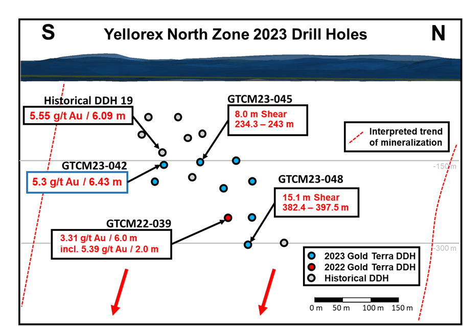
Gold Terra Resource (TSXV:YGT) has announced the first assay result from its winter drilling program on the Con Mine Option Property in Yellowknife, Northwest Territories. The drilling program aims to expand the Yellorex North gold zone from surface to 300 metres below surface. The property is under option from subsidiaries of Newmont Corporation and is acquirable by Gold Terra upon fulfillment of certain conditions.
The winter drilling program has completed ten holes, with eight on Yellorex North, totaling approximately 4,000 metres. The first hole of the program, GTCM23-042, intersected 5.3 g/t Au over 6.43 metres. The drill core from this hole will be on display at the Gold Terra Booth at the Prospectors & Developers Association of Canada Convention from March 5 to 8, where attendees can speak with management about the program and future objectives.
Chairman and CEO, Gerald Panneton, commented in a press release: “The Hole GTCM23-042 initial assay result is very encouraging as the intersection is 150 metres below surface, and fulfills our objective to expand the current near surface mineral resources on the CMO. We look forward to additional results as all eight holes have hit the targeted Campbell Shear and show significant intersections of visible multi-meter veining and sulphide mineralization. The Campbell Shear structure is our highest priority target as the Con Mine produced historically more than 5 million ounces of high-grade gold (16 g/t Au).”
Highlights from the result are as follows:
GTCM23-042 intersected 5.3 g/t Au over 6.43 metres and was designed to verify and add depth extension to historical high-grade mineralization encountered in the Yellorex North zone of the Campbell Shear, as shown in Figure 1 below. The Campbell Shear was intersected at approximately 150 metres below ground level.
The main intersection is between 236.5-242.93 metres down hole and contains approximately 6.5 metres of smoky quartz veining, strong sericite alteration, and strong pyrite and arsenopyrite mineralization. Veining, alteration, mineralization, and width are the most important factors for assessing zone potential as drilling occurs.
The focus of the winter drilling program is to expand the September 2022 initial Mineral Resource Estimate (“MRE”) (see September 7, 2022 press release) along the Campbell Shear immediately south of the Con Mine. The initial mineral resource estimate from drilling in 2022 is 109,000 Indicated ounces of contained gold and 432,000 Inferred ounces of contained gold between surface and to a depth of 400m below surface along a 2 km corridor. Please see the October 21, 2022 technical report, titled “Initial Mineral Resource Estimate for the CMO Property, Yellowknife City Gold Project, Yellowknife, Northwest Territories, Canada” with an effective date of September 2, 2022, by Qualified Person, Allan Armitage, Ph. D., P. Geo., SGS Geological Services, which can be found on the Company’s website at https://www.goldterracorp.com and on SEDAR at www.sedar.com.
The eight holes were drilled near surface on Yellorex North as this represents one of many under explored targets in the area. The target area is only 1 kilometre south of existing infrastructure, and tested only by one hole in 2022, GTCM22-039, (see August 3, 2022 press release) which returned two mineralized zones returning 3.31 g/t Au over 6.00 metres from 306.0 to 312.0 metres and including 5.39 g/t Au over 2.0 metres from 309.00 to 311.00 metres, and 2.18 g/t Au over 5.0 metres from 324.00 metres to 329.00 metres.
The above references an opinion and is for information purposes only. It is not intended to be investment advice. Seek a licensed professional for investment advice. The author is not an insider or shareholder of any of the companies mentioned above.
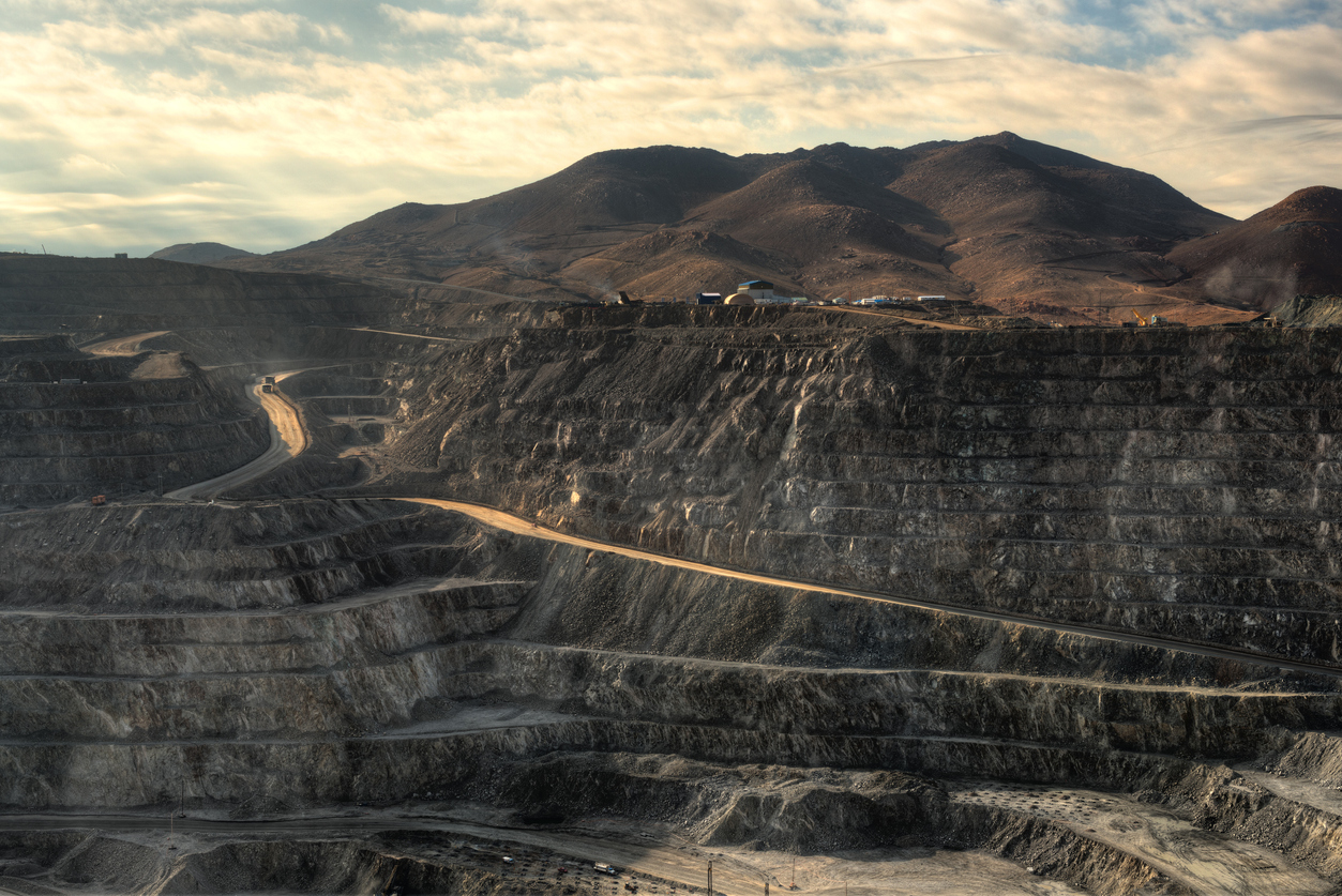
South America is home to some of the largest copper deposits in the world, and several exploration companies are working hard to discover new resources and expand existing ones. Here are the top three copper exploration companies in South America, along with some of their most notable intercepts.
Solaris Resources (TSX:SLS) (OTCQB:SLSSF)
Solaris Resources (TSX:SLS) (OTCQB:SLSSF) is a Canadian copper exploration company focused on the discovery and development of copper and gold deposits in the Americas. The company has a strong presence in South America, where it is actively exploring for copper and gold deposits in Ecuador and Peru.
The company continues to report regular exploration results expanding on its discoveries at what has been called a potential “superpit”.
Warintza is considered a take-out target as the Company has defined a large 1.5Bt copper inventory, featuring a high-grade starter pit and low strip ratio, within a mining district offering major structural advantages from highway access, abundant and low-cost hydroelectric power, fresh water, labour and low elevation. The Company has de-risked the project by locking in a social license through an IBA signed with the communities, and freezing in place the regulatory and fiscal framework by signing an Investment Contract with the Government in December. The final de-risking item is completing project permitting, which is ongoing and expected in 2024 with the project being designated a “strategic priority project” by the Government.
First Quantum Minerals (TSX:FM)
First Quantum Minerals (TSX:FM) is a Vancouver-based mining company with operations in Africa, Australia, and South America. Its flagship copper mine is the Cobre Panama project, located in Panama. The company has been exploring the region for years and has made several significant copper discoveries.
First Quantum has reported several impressive drill intercepts at Cobre Panama. One of the most notable was a 136-meter intersection of copper and gold mineralization, grading 0.63% copper and 0.35 grams per tonne of gold. This intercept was found in the southeast extension of the Cobre Panama deposit, and the company believes it has the potential to significantly increase the mine’s resources.
Anglo American (LSE:AAL)
Anglo American (LSE:AAL) is a multinational mining company with operations in Africa, Europe, and the Americas. Its copper operations are located in Chile, where it owns a 50% stake in the Los Bronces mine and a 100% stake in the Mantoverde mine.
Anglo American has reported several impressive drill intercepts at Los Bronces. One of the most significant was a 95-meter intersection of copper and molybdenum mineralization, grading 0.67% copper and 0.022% molybdenum. This intercept was found in the north zone of the mine, and the company believes it has the potential to increase the mine’s resources.
Teck Resources (NYSE:TECK)
Teck Resources (NYSE:TECK) is a Canadian mining company with operations in Canada, the United States, and Chile. Its copper operations are located in Chile, where it owns a 90% stake in the Quebrada Blanca mine.
Teck reported several intercepts at Quebrada Blanca since exploration began. One of the most biggest was in 2021; a 129-meter intersection of copper mineralization, grading 0.39% copper. This intercept was found in the QB2 deposit, which is currently under construction and expected to begin production in 2022. The company believes that QB2 has the potential to become a significant copper producer, with a projected mine life of over 25 years.
The above references an opinion and is for information purposes only. It is not intended to be investment advice. Seek a licensed professional for investment advice. The author is not an insider or shareholder of any of the companies mentioned above.
GR Silver Mining (TSXV:GRSL) has reported new results from its final round of underground drilling at the Plomosas Mine Area during its 2022 infill and exploratory drilling program at the Plomosas Project in Mexico. The company drilled all 28 drill holes in the announcements from within the historic Plomosas Mine Area, mainly about the 900 level.
Drill targeted the wide polymetallic Plomosas Breccia in unmined areas close to existing underground development and access. Objectives for the infill drilling program were achieved and delineated new mineralized zones, replacing un-sampled historical holes that were previous adopted in the 2021 resource estimation.
GR Silver Mining Chairman and CEO, Eric Zaunscherb commented in a press release: “The upcoming resource estimation is expected to define a significant resource dominated by silver mineralization over broad widths, relatively close to surface or existing underground infrastructure. We consider these attributes to contribute to GR Silver Mining’s competitive advantages, along with project scale and prospectivity, and the management and board skills to take the project to the next level. We anticipate a potential market re-rating related to the resource estimation update, based on scale and quality of resources.”
Highlights from the results are as follows:
- PLIP22-094: 21.7 m at 158 g/t Ag, 0.05 g/t Au, 1.9% Pb, 1.8% Zn and 0.1% Cu (301 g/t AgEq1)
including: 5.8 m at 427 g/t Ag, 0.09 g/t Au, 4.9% Pb, 1.4% Zn and 0.1% Cu (648 g/t AgEq) - PLIP22-092: 13.0 m at 161g/t Ag, 0.20 g/t Au, 1.0% Pb, 1.5% Zn and 0.1% Cu (273 g/t AgEq)
- PLIP22-089: 5.4 m at 325 g/t Ag, 0.54 g/t Au, 3.1% Pb, 2.5% Zn and 0.1% Cu (567g/t AgEq)
including: 2.5 m at 524 g/t Ag, 0.19 g/t Au, 2.7% Pb, 0.8% Zn and 0.1% Cu (660 g/t AgEq) - PLIP22-078: 4.7 m at 277 g/t Ag, 0.75 g/t Au, 7.5% Pb, 2.1% Zn and 0.2% Cu (666 g/t AgEq)
The drilling results continue to reveal attractive wide high-grade silver-polymetallic mineralization in unmined areas at the upper levels of the historic underground mine. These results continue to demonstrate the potential to incorporate wide and attractive polymetallic results into the upcoming resource estimation, scheduled for completion by the end of Q1|2023.
The 186 drill holes (11,750 metres), completed by GR Silver Mining at the Plomosas Mine Area since the 2021 resource estimation, have added important core drilling in specific areas of the existing NI 43-101 resource block model, which together with 36,400 metres of historical drilling completed by First Majestic, Aurcana and IMMSA, provide a higher density and confidence of information for the resource estimation in progress.
Table 1: Plomosas Mine Area – Latest Results Highlights
| Drill Hole | From (m) | To (m) | Apparent
width (m) |
True width
(m) |
Ag g/t | Au g/t | Pb % | Zn % | Cu % | AgEq g/t |
| PLI22-53 | 2.3 | 3.8 | 1.5 | 1.0 | 270 | 0.15 | 0.8 | 1.1 | na | 348 |
| 42.4 | 45.8 | 3.4 | 2.9 | 251 | 0.01 | 2.2 | 2.4 | na | 412 | |
| PLIP22-60 | No significant intervals | |||||||||
| PLIP22-61 | 6.3 | 8.3 | 2.0 | 1.7 | 80 | 0.01 | 0.4 | 0.5 | 0.1 | 118 |
| PLIP22-62 | No significant intervals | |||||||||
| PLIP22-64 | No significant intervals | |||||||||
| PLIP22-66 | 0.8 | 14.1 | 13.2 | 8.5 | 44 | 0.06 | 0.3 | 0.4 | na | 74 |
| PLIP22-71 | 0.0 | 7.7 | 7.7 | 6.3 | 8 | 0.08 | 0.8 | 0.6 | na | 61 |
| PLIP22-72 | 0.0 | 1.9 | 1.9 | 1.9 | 23 | 2.31 | 1.9 | 3.8 | na | 437 |
| PLIP22-73 | No significant intervals | |||||||||
| PLIP22-74 | 0.8 | 13.0 | 12.2 | 12.2 | 42 | 0.70 | 0.5 | 0.4 | na | 139 |
| PLIP22-75 | 2.0 | 6.1 | 4.1 | 4.1 | 3 | 0.13 | 0.8 | 0.5 | na | 57 |
| PLIP22-76 | No significant intervals | |||||||||
| PLIP22-78 | 4.8 | 9.5 | 4.7 | 4.7 | 277 | 0.75 | 7.5 | 2.1 | 0.2 | 666 |
| PLIP22-79 | No significant intervals | |||||||||
| PLIP22-80 | No significant intervals | |||||||||
| PLIP22-82 | 1.3 | 4.6 | 3.3 | 3.3 | 37 | 0.08 | 0.1 | 0.2 | na | 56 |
| PLIP22-84 | No significant intervals | |||||||||
| PLIP22-85 | 0.0 | 5.3 | 5.3 | 4.3 | 23 | na | 1.1 | 6.0 | 0.1 | 293 |
| 0.0 | 0.9 | 0.9 | 0.7 | 48 | 0.01 | 4.3 | 17.2 | 0.2 | 849 | |
| PLIP22-86 | 0.0 | 5.3 | 5.3 | 3.4 | 24 | 0.04 | 1.9 | 2.0 | na | 161 |
| PLIP22-87 | 1.6 | 9.3 | 7.7 | 5.9 | 7 | 0.06 | 0.4 | 0.4 | na | 40 |
| PLIP22-88 | 6.5 | 13.2 | 6.8 | 5.9 | 45 | 0.09 | 0.1 | 0.1 | na | 62 |
| PLIP22-89 | 9.0 | 14.3 | 5.4 | 4.7 | 325 | 0.54 | 3.1 | 2.5 | 0.1 | 567 |
| 10.9 | 13.4 | 2.5 | 2.0 | 524 | 0.19 | 2.7 | 0.8 | 0.1 | 660 | |
| PLIP22-90 | 5.2 | 6.5 | 1.3 | 0.8 | 46 | 0.11 | 2.2 | 3.5 | 0.1 | 258 |
| PLIP22-92 | 5.6 | 18.6 | 13.0 | 11.3 | 161 | 0.20 | 1.0 | 1.5 | 0.1 | 273 |
| PLIP22-93 | 11.7 | 14.7 | 3.0 | 2.6 | 210 | 0.03 | 0.8 | 0.2 | 0.1 | 257 |
| 11.7 | 12.3 | 0.6 | 0.5 | 485 | 0.09 | 4.3 | 0.2 | 0.3 | 660 | |
| PLIP22-94 | 0.0 | 21.7 | 21.7 | 19.7 | 158 | 0.05 | 1.9 | 1.8 | 0.1 | 301 |
| 9.3 | 15.1 | 5.8 | 5.3 | 427 | 0.09 | 4.9 | 1.4 | 0.1 | 648 | |
| PLIP22-95 | No significant intervals | |||||||||
| PLIP22-96 | 7.4 | 9.4 | 2.1 | 2.0 | 276 | 0.01 | 0.5 | 1.1 | na | 338 |
| 14.3 | 19.4 | 5.2 | 3.3 | 43 | 0.06 | 1.1 | 0.5 | na | 103 | |
| Numbers may be rounded. Results are uncut and undiluted. “na” = no significant result |
| * AgEq calculations using US$20.00/oz Ag, US$1,600/oz Au, US$0.90/lb Pb, US$1.10/lb Zn and US$3.00/lb Cu, with metallurgical recoveries of Ag – 74%, Au – 86%, Pb – 69%, Zn –75% and Cu – 80%. AgEq = ((Ag grade x Ag Price x Ag recovery) + (Au grade x Au price x Au recovery) + (Pb grade x Pb price x Pb recovery) + (Zn grade x Zn price x Zn recovery) + (Cu grade x Cu price x Cu recovery))/(Ag price x Ag recovery) |
Table 2: Plomosas Mine Area Latest Drill Hole Details
| Drill Hole | East (m) | North (m) | RL (m) | Dip (˚) | Azimuth (˚) | Depth (m) | Drill Hole Type |
| PLI22-53 | 451307 | 2551909 | 818 | 55 | 270 | 78.0 | Underground |
| PLIP22-60 | 451532 | 2552237 | 897 | 45 | 310 | 16.0 | Underground |
| PLIP22-61 | 451517 | 2552066 | 917 | -44 | 110 | 18.7 | Underground |
| PLIP22-62 | 451512 | 2552050 | 919 | -44 | 140 | 16.5 | Underground |
| PLIP22-64 | 451474 | 2552010 | 903 | -53 | 103 | 15.0 | Underground |
| PLIP22-66 | 451473 | 2551899 | 903 | -32 | 50 | 14.7 | Underground |
| PLIP22-71 | 451297 | 2551672 | 801 | -47 | 65 | 17.75 | Underground |
| PLIP22-72 | 451325 | 2551606 | 801 | -50 | 50 | 18.0 | Underground |
| PLIP22-73 | 451350 | 2551595 | 802 | -60 | 47 | 16.0 | Underground |
| PLIP22-74 | 451409 | 2551539 | 804 | -26 | 320 | 15.0 | Underground |
| PLIP22-75 | 451415 | 2551561 | 804 | -25 | 329 | 15.0 | Underground |
| PLIP22-76 | 451312 | 2551886 | 817 | 0 | 141 | 31.0 | Underground |
| PLIP22-78 | 451232 | 2551853 | 801 | -25 | 115 | 41.5 | Underground |
| PLIP22-79 | 451377 | 2551581 | 802 | -45 | 60 | 15.0 | Underground |
| PLIP22-80 | 451378 | 2551568 | 803 | -43 | 85 | 14.0 | Underground |
| PLIP22-82 | 451345 | 2551862 | 851 | -50 | 80 | 21.25 | Underground |
| PLIP22-84 | 451410 | 2552076 | 854 | 0 | 270 | 12.4 | Underground |
| PLIP22-85 | 451336 | 2551983 | 853 | -20 | 260 | 20.5 | Underground |
| PLIP22-86 | 451337 | 2551961 | 853 | -45 | 90 | 12.5 | Underground |
| PLIP22-87 | 451396 | 2551889 | 852 | -20 | 70 | 29.0 | Underground |
| PLIP22-88 | 451428 | 2551885 | 852 | -45 | 80 | 38.0 | Underground |
| PLIP22-89 | 451345 | 2551739 | 842 | -80 | 110 | 28.0 | Underground |
| PLIP22-90 | 451331 | 2551733 | 844 | 0 | 260 | 19.4 | Underground |
| PLIP22-92 | 451400 | 2551467 | 882 | -30 | 90 | 40.5 | Underground |
| PLIP22-93 | 451367 | 2551951 | 881 | -30 | 90 | 14.7 | Underground |
| PLIP22-94 | 451387 | 2551974 | 880 | -28 | 90 | 21.65 | Underground |
| PLIP22-95 | 451330 | 2551892 | 873 | -90 | 0 | 8.0 | Underground |
| PLIP22-96 | 451342 | 2551939 | 869 | -20 | 70 | 21.0 | Underground |
| Note: WGS84 Datum |
The above references an opinion and is for information purposes only. It is not intended to be investment advice. Seek a licensed professional for investment advice. The author is not an insider or shareholder of any of the companies mentioned above.
If you would like to receive our free newsletter via email, simply enter your email address below & click subscribe.
 Follow us on Twitter
 Become our facebook fan
CONNECT WITH US
Tweets
Tweet with hash tag #miningfeeds or @miningfeeds and your tweets will be displayed across this site.
MOST ACTIVE MINING STOCKS
Daily Gainers
 CMC Metals Ltd. CMC Metals Ltd. |
CMB.V | +900.00% |
 Eden Energy Ltd Eden Energy Ltd |
EDE.AX | +200.00% |
| GoviEx Uranium Inc. |
GXU.V | +42.86% |
| Eagle Nickel Ltd. |
ENL.AX | +41.67% |
| Citigold Corp. Limited |
CTO.AX | +33.33% |
| Mount Burgess Mining NL |
MTB.AX | +33.33% |
| Exalt Resources Limited |
ERD.AX | +31.94% |
| Casa Minerals Inc. |
CASA.V | +30.00% |
| Cariboo Rose Resources Ltd |
CRB.V | +28.57% |
| Belmont Resources Inc. |
BEA.V | +28.57% |