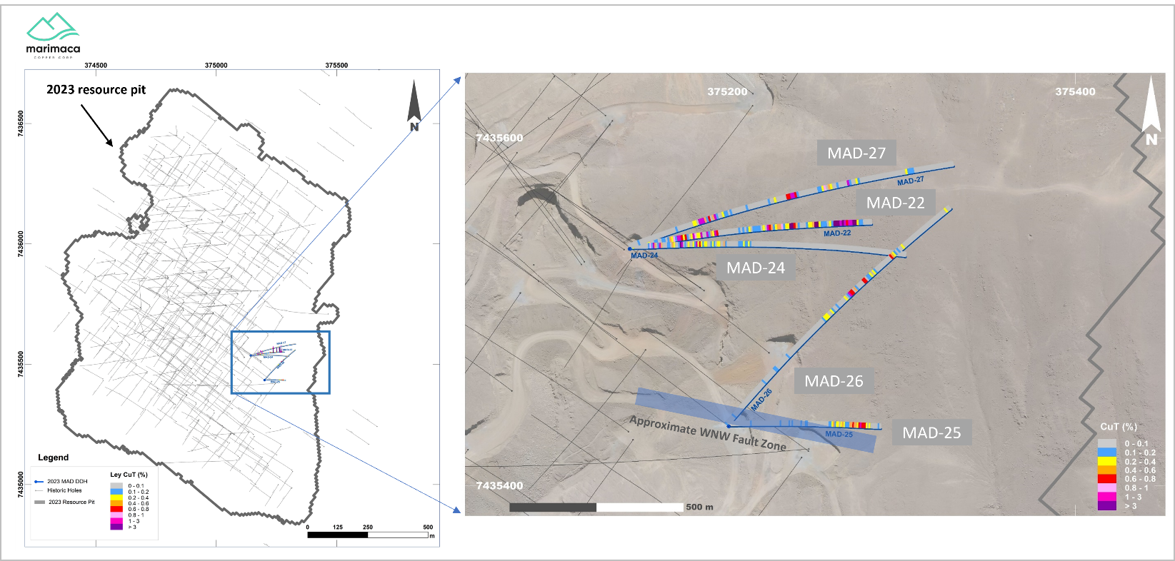
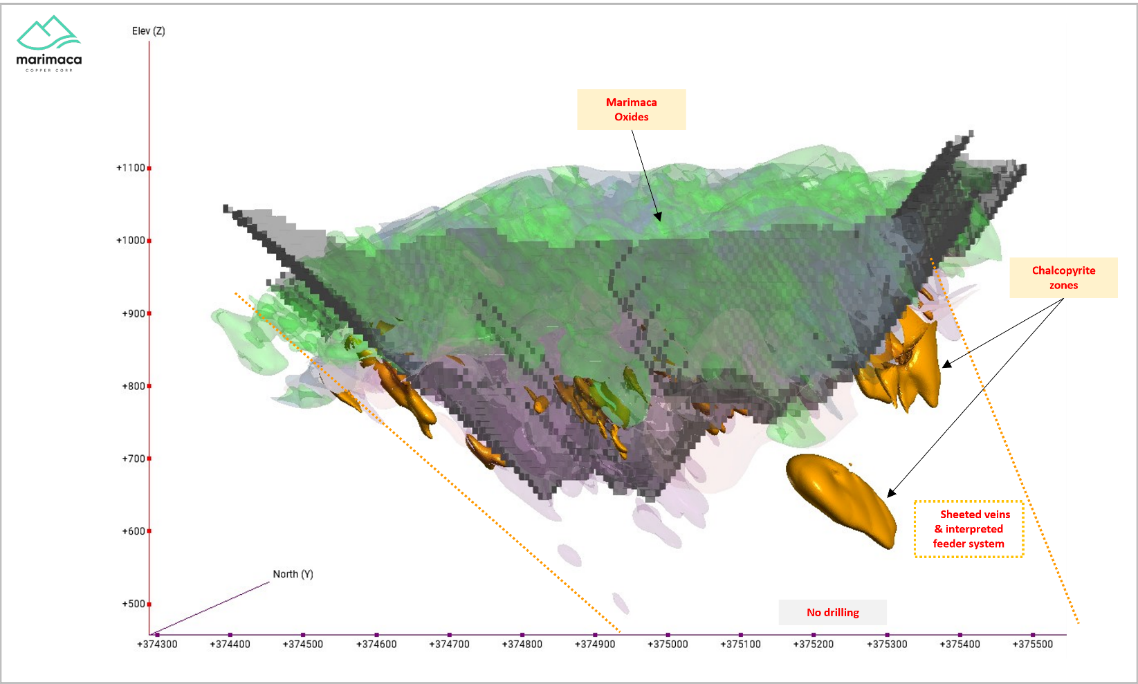
Marimaca Copper (TSX:MARI) has reported the latest findings of its recent five-hole diamond drilling exploration program at the eastern edge of the Marimaca Oxide Deposit (MOD). The program was initially carried out to follow up on the sulphide-bearing intersection of the formerly disclosed hole MAD-22, renowned for its higher concentration of primary copper mineralization located down-dip of the Marimaca oxides.
Sergio Rivera, VP Exploration at Marimaca Copper, commented in a press release: “Despite challenging drilling conditions we continue to improve our understanding of Marimaca’s genesis and target generation for the potential sulphide feeder zones. We are very encouraged to see the continuation of the alteration assemblages and rock types observed in MAD-22 in the follow-up program, which is the first time that consistent sulphide-associated alteration has been observed below the MOD. MAD-25, in particular, which stepped out 500m to the south of MAD-22, intersected the expected alteration mineral assemblages with strong mineralization at the targeted horizon, but was terminated before the expected higher-grade zone due to the intersection of a fault zone, which deviated the hole.
Planning for the next phase of sulphide exploration will incorporate learnings from this first phase campaign, including adjusting the approach to drilling from east to west to allow for easier orientation of the drilling to the deeper target horizons. Approaching from the west will take time to plan new drilling infrastructure rather than using existing eastern drill pads at the MOD, however we believe the sulphide potential warrants this. We continue to believe that the sulphide potential is high, particularly considering the scale of the oxidized mineralized body at the MOD and the indications, such as Hole MAD-22, that higher grade remnant feeder structures, remain intact in the shallower down-dip zones of the MOD.”
Drilling operations faced considerable difficulties, largely due to the direction of drilling from existing pads along the MOD’s primary known structures. The data generated from this effort, along with insights regarding future deeper drilling tactics, especially their origin and orientation, will inform the layout of ensuing exploration activities.
Expanding on individual drill hole observations, hole MAD-25 was a 500m step out to the south of MAD-22. It discovered strong mixed and primary sulphide mineralization from nearly the projected target horizon, which was roughly 136m downhole. However, operations were halted at 218m due to an encountered fault.
Holes MAD-25, 26, and 27 intersected extensions of alteration-mineralization assemblages similar to those found in MAD-22. These included sections displaying massive to stringer filling chalcopyrite and pyrite and pervasive hydrothermal magnetite replacement. The latter was partially linked to coarse actinolite veinlets associated with the porphyritic quartz-diorite intrusion host rock.
The drill holes were found immediately adjacent to the eastern wall of the whittle pit limits, in accordance with the Mineral Resource Estimate (MRE) from October 2022. This positioning indicates the possibility of high-grade, open-pit-able mineralization.
The sulphide copper mineralization observed in the deeper mineralized intercepts appeared less consistent than in MAD-22, which was attributed to variability in the pyrite/chalcopyrite ratio in the primary zones. Such variation is typical in Iron Oxide Copper Gold (IOCG) systems and requires further analysis to vector to the zones bearing a higher amount of chalcopyrite. This particular observation was corroborated in MAD-26, which intersected strong magnetite alteration from 186m. Nonetheless, it presented a higher pyrite/chalcopyrite ratio compared to MAD-22, which corresponds to lower grade copper intersections.
Highlights from the results are as follows:
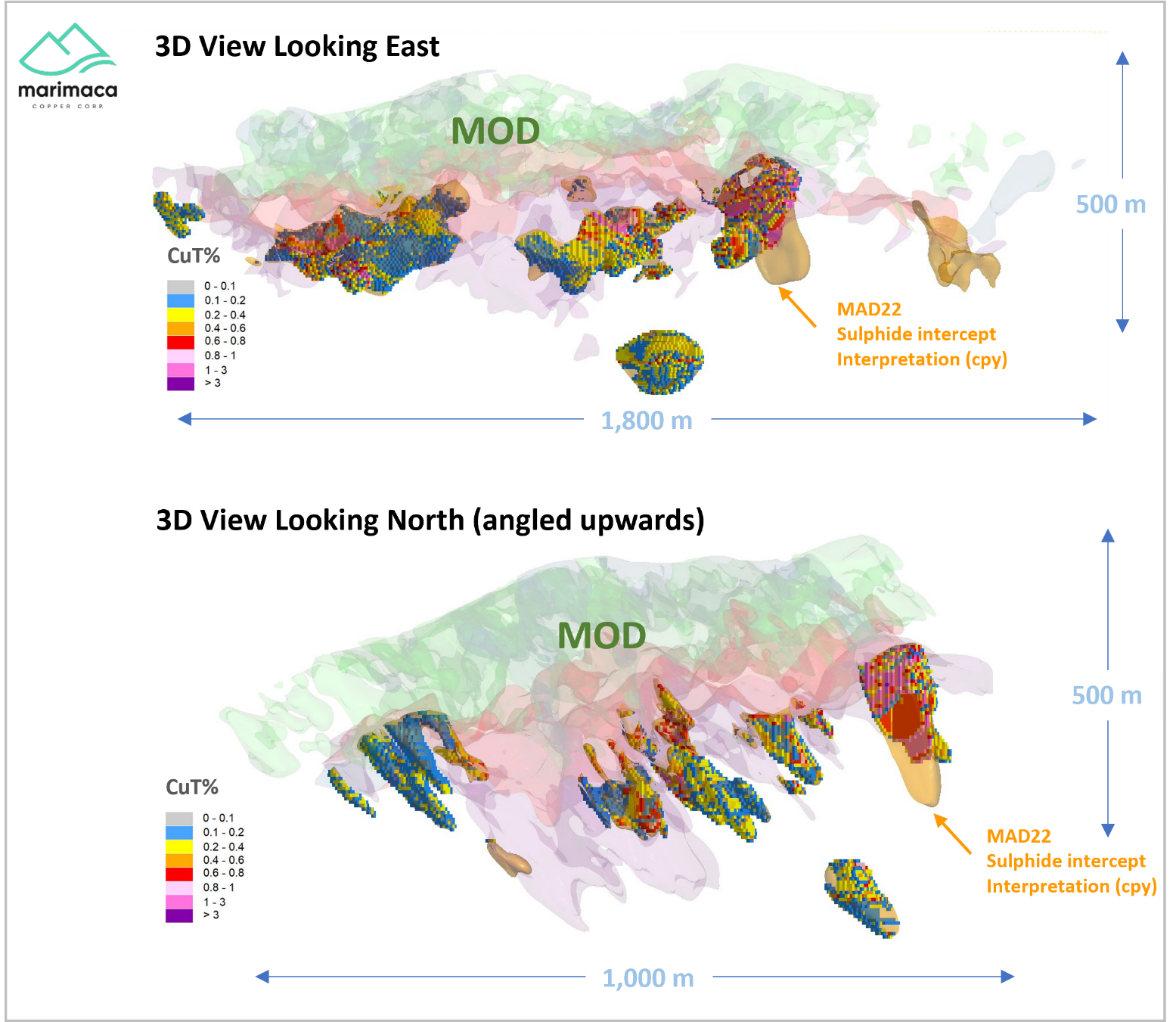
- Four drill holes recovered to a maximum depth of 349m from surface, with three holes completed successfully to target depth
- The fourth hole, although recovered, MAD-25 was terminated above target depth due to poor rock quality caused by localized faulting
- Holes MAD-24, 25, 26 and 27 intersected the extension of the upper oxide and mixed/enriched copper mineralization
- This zone is interpreted as the near-surface, oxidized expressions of high-grade mineralized structures encountered in MAD-22
- MAD-25 intersected 56m at 0.40% CuT from 136m including 24m at 0.63% CuT of secondary and primary sulphides in-line with the projected horizon from MAD-22, however, could not progress further into the horizon due to rock quality in a fault zone and was terminated at 218m
- Hole MAD-24 intersected 74m of 0.52% CuT from 24m including 18m at 0.68% CuT from 24m and 28m at 0.79% CuT from 64m above the projected sulphide horizon
- Hole MAD-24 intersected a barren post-mineral dyke from 224.3m which occupied the projected extension of the sulphide horizon from MAD-22
- Hole MAD-27 intersected 40m at 0.50% CuT from 68m including 18m at 0.90% CuT of mixed and enriched mineralization from 74m, and a deeper intersection of 12m at 1.0% CuT of chalcopyrite mineralization from 162m
- Hole MAD-26 intersected strong magnetite alteration from 186m, however with a higher pyrite/chalcopyrite ratio relative to MAD-22 corresponding to lower grade copper intersections
- MAD-23 was terminated as a result of contractor operational performance leading to contractor replacement for subsequent holes (MAD-24, 25, 26, 27)
The above references an opinion and is for information purposes only. It is not intended to be investment advice. Seek a licensed professional for investment advice. The author is not an insider or shareholder of any of the companies mentioned above.
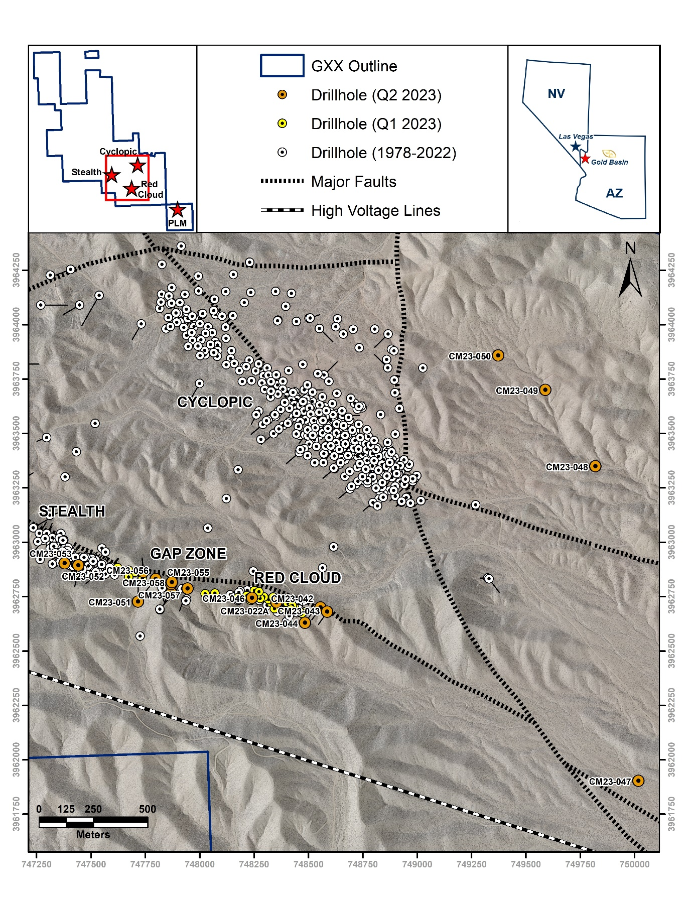
Gold Basin Resources (TSXV:GXX) has reported preliminary results from their extensive 2,224-metre follow-up drill program. The investigation is taking place at the company’s fully-owned Gold Basin oxide gold project, located in north-western Arizona.
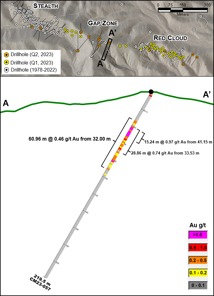
Colin Smith, CEO of Gold Basin, commented in a press release: “Preliminary assays from drilling in the Gap Zone between the Stealth and Red Cloud Deposits are very encouraging, with drillhole CM23-057, located dead-centre of the Gap, intercepting a broad zone of near-surface oxide gold comparable in grade and thickness to typical holes in the neighboring deposits. This suggests the presence of a contiguous 1.5-km-long oxide gold system throughout the Stealth-Red Cloud trend, situated only 900 metres from the 1.7-km-long Cyclopic Deposit.”
Significant near-surface oxide gold intercepts were reported at the Red Cloud Deposit, with several over 60 metres in thickness. For example, one intercept included 69.08 metres with 1.03 g/t Au from 6.10 metres in hole CM23-022A. Within this intercept, there was a section of 48.77 metres with 1.31 g/t Au from 10.67 metres.
Moreover, a substantial oxide gold intercept was discovered in the central Gap Zone, a region between Stealth Deposit and Red Cloud. This intercept comprised 60.96 metres with 0.46 g/t Au from 32.00 metres in hole CM23-057, including a part of 28.86 metres with 0.74 g/t Au from 33.53 metres. These results indicate a continuous oxide gold system along the entire 1.5-kilometre trend.
Another remarkable discovery was an anomalous oxide gold intercept, 1,700 metres step-out along strike to southeast from Red Cloud. This find, located in drillhole CM23-047, indicates that the mineralized detachment fault gold system remains intact and is promising throughout the entire open strike length. It has been identified as a priority drill target for Q3/Q4 2023.
In total, the drilling operation saw 18 RC holes and covered a distance of 2,224 metres. The results of the assays for 7 holes are still awaited. Additionally, preparations are underway for follow-up fieldwork on the 3.25-km-long, 1.7-km-long and 1.0-km-long gold trends north and east of the Cyclopic Deposit. This upcoming work will also cover the seven new visible gold occurrences discovered during Q2 2023 soil and rock sampling.
The 2023 Phase 2 Resource Definition Drill Program is focusing on examining the Gap Zone between Red Cloud and Stealth, the southeast strike of Red Cloud, and select reconnaissance targets distal to the main deposit areas. Of the 11 holes with complete results, six returned near-surface intervals of oxide gold mineralization, predominantly located from the surface to a vertical depth of 60 metres.
The regional reconnaissance drillhole CM23-047, 1.7 km along strike to the southeast from Red Cloud, offered significant findings. The results show the gold-bearing detachment fault hosting both Stealth and Red Cloud remains intact and gold-rich at least 1.7 km southeast and along the strike from Red Cloud. The extension to the trend represents a high-priority drill target for later in 2023.
Highlights from the results are as follows:
- Multiple at- or near-surface oxide gold intercepts at the Red Cloud Deposit (“Red Cloud”) over 60 metres (“m”) in thickness, including:
- 69.08 m @ 1.03 g/t Au from 6.10 m in hole CM23-022A
- incl. 48.77 m @ 1.31 g/t Au from 10.67 m
- 64.01 m @ 0.56 g/t Au from 0.00 m CM23-046
- incl. 30.48 m @ 1.00 g/t Au from 0.00 m;
- 69.08 m @ 1.03 g/t Au from 6.10 m in hole CM23-022A
- Key near-surface oxide gold intercept in the central “Gap Zone” between Stealth Deposit (“Stealth”) and Red Cloud:
- 60.96 m @ 0.46 g/t Au from 32.00 m in hole CM23-057
- incl. 28.86 m @ 0.74 g/t Au from 33.53 m
- Suggests continuity of an oxide gold system along full 1.5-km-long trend;
- 60.96 m @ 0.46 g/t Au from 32.00 m in hole CM23-057
- Entire trend is largely open at depth and along strike;
- Anomalous oxide gold intercept 1,700 m step-out along strike to southeast from Red Cloud, 3.04 m @ 0.13 g/t Au from 67.06 m in drillhole CM23-047:
- Indicates the mineralized detachment fault gold system is intact and highly prospective along entire open strike length – priority drill target for Q3/Q4 2023;
- Total of 2,224 m drilled in 18 RC holes, with assays pending for 7 holes;
- Follow-up fieldwork is under preparation for the 3.25-km-long, 1.7-km-long and 1.0-km-long gold trends north and east of the Cyclopic Deposit, as well as the 7 new visible gold occurrences discovered during Q2 2023 soil and rock sampling.
Table 1: Significant drillhole intersections from the Q2 2023 follow-up Drill program. All intersections are interpreted to be true width.
| Target | Drillhole | From
(m) |
To
(m) |
Length
(m) |
Au
(g/t) |
Interval Summary |
| Red Cloud | CM23-022A | 6.10 | 71.63 | 67.07 | 1.03 | 69.08 m @ 1.03 g/t Au from 6.10 m |
| Red Cloud | CM23-022A | 10.67 | 57.91 | 48.77 | 1.31 | 48.77 m @ 1.31 g/t Au from 10.67 m |
| Red Cloud | CM23-044 | 9.14 | 18.29 | 9.15 | 1.03 | 9.15 m @ 1.03 g/t Au from 9.14 m |
| Red Cloud | CM23-044 | 16.76 | 18.29 | 1.52 | 5.73 | 1.52 m @ 5.73 g/t Au from 16.76 m |
| Red Cloud | CM23-046 | 0.00 | 64.01 | 64.01 | 0.56 | 64.01 m @ 0.56 g/t Au from 0.00 m |
| Red Cloud | incl. | 0.00 | 28.96 | 30.48 | 1.00 | 30.48 m @ 1.00 g/t Au from 0.00 m |
| Regional Recon | CM23-047 | 67.06 | 70.10 | 3.04 | 0.13 | 3.04 m @ 0.13 g/t Au from 67.06 m |
| Regional Recon | CM23-048 | 0.00 | 21.34 | 21.34 | 0.10 | 21.34 m @ 0.10 g/t Au from 0.00 m |
| Regional Recon | incl. | 13.72 | 16.76 | 3.04 | 0.51 | 3.04 m @ 0.51 g/t Au from 13.72 m |
| Gap Zone | CM23-057 | 32.00 | 91.44 | 60.96 | 0.46 | 60.96 m @ 0.46 g/t Au from 32.00 m |
| Gap Zone | incl. | 33.53 | 56.39 | 28.86 | 0.74 | 28.86 m @ 0.74 g/t Au from 33.53 m |
The above references an opinion and is for information purposes only. It is not intended to be investment advice. Seek a licensed professional for investment advice. The author is not an insider or shareholder of any of the companies mentioned above.
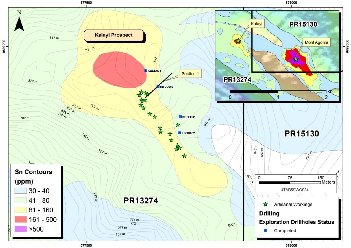
Rome Resources (TSXV:RMR), has reported the discovery of tin mineralization at its Kalayi Prospect, part of the Bisie North Tin Project (BNTP), located in the Walikale District of North Kivu Province, Democratic Republic of the Congo. This finding is based on results from handheld XRF analyses performed on samples gathered during a recent diamond drilling campaign.
CEO and President Mark Gasson, commented in a press release: “We are extremely excited about the new discovery at Kalayi. To date the Company has tested 150m of the defined 2km tin in soil anomaly where we are confident of identifying additional drill targets with infill sampling, trenching and systematic exploration. We consider the initial drilling at Kalayi to be hugely successful as it is unusual to have two intersections of this magnitude from a first round of drilling, given the team’s understanding of mineralisation along the Bisie Ridge. This team was responsible for the exploration and resource drilling on Alphamin’s world-class tin projects.”
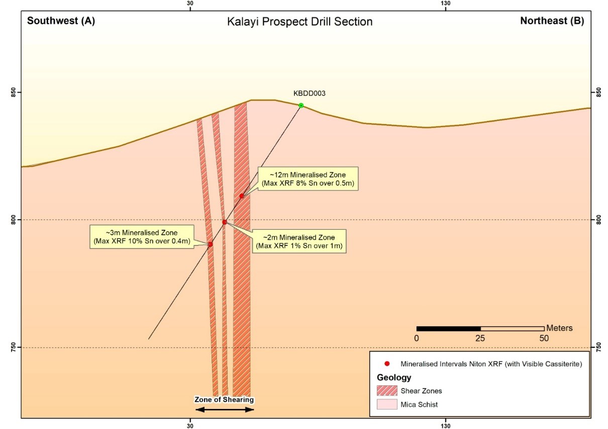
The BNTP is comprised of two adjoining properties: exploration permits PR 13274 and PR 15130. The Kalayi Prospect was assessed by drilling four diamond holes to a cumulative depth of 463.5 meters, probing beneath the site’s artisanal workings, which were previously found to contain as much as 11% tin in some 1-meter samples.
This drilling activity revealed significant mineralization within a 150-meter range of a larger 2,000-meter tin-in-soil anomaly. The most notable tin deposits were identified within pulps from samples taken from the two discovery holes, KBDD002 and KBDD003. Visible cassiterite (tin ore) was observed throughout most of the mineralized zones. The highest-grade tin concentrations were found in three distinct shear zones, including an 8% concentration in a 12.5-meter zone, 1% in a 2-meter zone, and 10% in a 3-meter zone. Meanwhile, hole KBDD002 registered a maximum of 6% tin concentration in a 2.5-meter zone.
The tin mineralization at Kalayi is unique, being found within specific quartz veined shear zones inside mica schists, with no associations to copper, zinc, or lead as seen in the company’s Mont Agoma Prospect. This pattern of mineralization aligns with those found along the Bisie ridge, characterized by distinct shoot geometry, with fluctuating grades and widths in neighboring drill holes.
Moving forward, Rome Resources plans to initiate infill soil sampling and trenching programs where overburden is not excessive, aiming to identify surface mineralized quartz veins. These findings will guide further drilling operations at depth and along the strike of the 2km tin-in-soil anomaly. In addition, any new underground artisanal workings will be mapped to enhance understanding of the controlling structures’ orientation and width variations.
Highlights from the results are as follows:
- Significant tin mineralisation identified visually and from the handheld XRF analyser on pulps from 2 of 4 diamond holes
- A 12.5m zone with a maximum grade, pursuant to handheld XRF analyses, of 0.5m at 8% Sn within a broader shear zone which included a further 3m zone with a maximum of 10% Sn was identified in KBDD003; a 2.5m zone with a maximum grade of 6% Sn in KBDD002
- Assay results from July drilling program expected in August 2023
- Drilling covered 150m of strike of an associated 2,000m tin in soil anomaly at the Kalayi Prospect
- The Company is currently conducting infill soil sampling and trenching programmes to assist with planning of the next phase of drilling
The above references an opinion and is for information purposes only. It is not intended to be investment advice. Seek a licensed professional for investment advice. The author is not an insider or shareholder of any of the companies mentioned above.
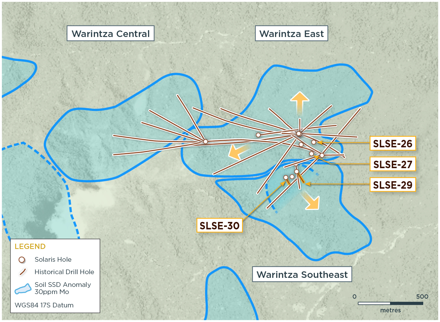
Solaris Resources (TSX: SLS)(OTCQB:SLSSF) has reported assay results from numerous boreholes, which were aimed at expanding mineral resources at the Warintza Project, located in southeastern Ecuador. A visual representation of the results can be found in Figure 1, while Tables 1-2 provide detailed results.
Warintza East, discovered in July 2021, had eight drill holes incorporated into the Warintza Central Mineral Resource Estimate in April 2022. Further drilling operations have notably enlarged the size of the deposit, with drilling efforts set to augment resource growth in various directions, including north, northeast, east, and southwest.
Warintza Southeast, a distinct, higher-grade porphyry center south of Warintza East, was identified in May 2023. Positioned beyond the MRE’s boundary, it presents a prospect for adding higher-grade mineral resources. Presently, deeper drilling is being executed, with considerable step-outs toward the southeast in the pipeline. The findings draw from discovery hole SLSE-28, which unveiled a 301m open-ended interval of 0.65% CuEq² in an advantageous andesite porphyry host (Refer to the press release dated June 1, 2023). This data assists in establishing the system’s upper part’s geometry and offers vectors for additional drilling.
Hole SLSE-29 was launched east of SLSE-28 and drilled southeast to the KD-200 rig’s limit, going through a less receptive intermineral diorite porphyry. It returned 175m of 0.50% CuEq² within 289m of 0.40% CuEq² from near the surface. The last 105m averaged 0.60% CuEq², with depth remaining open.
Hole SLSE-30, commenced west of the discovery hole SLSE-28, was drilled southeast to the KD-200 rig’s limit. It yielded 30m of 0.53% CuEq² from near the surface within a wider interval of 275m of 0.48% CuEq². The concluding 41m averaged 0.60% CuEq², still open to depth.
Current operations are underway for deeper drilling that targets extensions of higher-grade intervals observed at the end of each hole. In addition, two more platforms are being developed for step-outs 250m and 500m to the southeast. This area has previously recorded XRF³ values of 0.3% to 0.5% Cu in andesite porphyry.
Highlights from the results are as follows:
Warintza East was discovered in July 2021, with eight drill holes included in the Warintza Central Mineral Resource Estimate (“MRE”)¹ in April 2022. Subsequent drilling has significantly expanded the dimensions of the deposit, with drilling targeting further resource growth to the north, northeast, east and southwest.
- SLSE-27 was collared on the eastern limit of the Warintza East drill grid and drilled vertically to the limit of the KD-200 rig, returning 132m of 0.60% CuEq² from near surface within a broader interval of 246m of 0.55% CuEq², bottoming in mineralization and remaining open at depth
- SLSE-26 was collared 100m north of SLSE-27 and drilled vertically to the limit of the KD-200 rig, returning 212m of 0.52% CuEq² within a broader interval of 310m of 0.45% CuEq² from surface, ending in mineralization and remaining open at depth
- Step-out and deeper drilling is planned with two platforms under construction and a further six scheduled to extend the drilling grid to the north, northeast, east, and southwest
Warintza Southeast was discovered in May 2023 as a distinct, higher-grade porphyry center to the south of Warintza East beyond the limit of the MRE and offers potential to add higher-grade mineral resources, with deeper drilling underway and significant step-outs to the southeast planned.
- These holes follow discovery hole SLSE-28, which returned an open-ended interval of 301m of 0.65% CuEq² in a favourable andesite porphyry host (see press release dated June 1, 2023), and helps establish the geometry of the upper part of the system and vectors for further drilling
- SLSE-29 was collared east of SLSE-28 and drilled southeast to the limit of the KD-200 rig through a less receptive intermineral diorite porphyry, returning 175m of 0.50% CuEq² within 289m of 0.40% CuEq² from near surface, with the final 105m averaging 0.60% CuEq² and open to depth
- SLSE-30 was collared west of discovery hole SLSE-28 and drilled southeast to the limit of the KD-200 rig, returning 30m of 0.53% CuEq² from near surface within a broader interval of 275m of 0.48% CuEq², with the final 41m averaging 0.60% CuEq² and remaining open to depth
- Deeper drilling targeting extensions of higher-grade intervals noted at the end of each hole is underway and two additional platforms are under construction for step-outs 250m and 500m to the southeast where XRF³ values of 0.3% to 0.5% Cu in andesite porphyry were recorded
Table 1 – Assay Results
| Hole ID | Date Reported | From (m) | To (m) | Interval (m) | Cu (%) | Mo (%) | Au (g/t) | CuEq² (%) |
| SLSE-30 | Jul 24, 2023 | 34 | 309 | 275 | 0.40 | 0.01 | 0.05 | 0.48 |
| Including | 34 | 64 | 30 | 0.42 | 0.02 | 0.05 | 0.53 | |
| Including | 268 | 309 | 41 | 0.51 | 0.01 | 0.08 | 0.60 | |
| SLSE-29 | 20 | 309 | 289 | 0.31 | 0.02 | 0.05 | 0.40 | |
| Including | 134 | 309 | 175 | 0.39 | 0.02 | 0.05 | 0.50 | |
| Including | 204 | 309 | 105 | 0.49 | 0.02 | 0.07 | 0.60 | |
| SLSE-27 | 48 | 294 | 246 | 0.43 | 0.02 | 0.07 | 0.55 | |
| Including | 50 | 182 | 132 | 0.47 | 0.02 | 0.06 | 0.60 | |
| SLSE-26 | 0 | 310 | 310 | 0.34 | 0.02 | 0.05 | 0.45 | |
| Including | 24 | 236 | 212 | 0.40 | 0.02 | 0.06 | 0.52 | |
| SLSE-28 | Jun 1, 2023 | 8 | 309 | 301 | 0.54 | 0.02 | 0.07 | 0.65 |
| Including | 278 | 309 | 31 | 0.68 | 0.01 | 0.07 | 0.76 |
Notes to table: True widths of the mineralized zone are not known at this time.
Table 2 – Collar Location
| Hole ID | Easting | Northing | Elevation (m) |
Depth (m) |
Azimuth (degrees) |
Dip (degrees) |
| SLSE-30 | 801389 | 9647867 | 1184 | 309 | 150 | -80 |
| SLSE-29 | 801467 | 9647904 | 1180 | 309 | 150 | -80 |
| SLSE-28 | 801438 | 9647864 | 1162 | 309 | 0 | -90 |
| SLSE-27 | 801574 | 9648054 | 1218 | 294 | 0 | -90 |
| SLSE-26 | 801593 | 9648138 | 1153 | 310 | 0 | -90 |
Notes to table: The coordinates are in WGS84 17S Datum.
The above references an opinion and is for information purposes only. It is not intended to be investment advice. Seek a licensed professional for investment advice. The author is not an insider or shareholder of any of the companies mentioned above.
Green River Gold (CSE:CCR) continues to progress its exploration efforts at the Quesnel Nickel Project with the announcement of the ongoing drilling of the project’s 46th hole. A preliminary analysis using X-Ray Fluorescence (XRF) technology suggests that this drill hole manifests mineralization characteristics similar to those found in the preceding 45 holes, starting from the bedrock surface. The Quesnel Nickel Project, situated 40 kilometers east by road from the company’s hub in Quesnel, British Columbia, is fully owned by the company. This location is within the well-known Cariboo Mining District of South Central British Columbia, Canada.
Kyle Townsend, the Mine Manager for Green River Gold Corp., commented in a press release: “We continue to demonstrate the size and consistency of the nickel showing at the Quesnel Nickel Project, with our 45th consecutive drill hole intersecting mineralization from the bedrock surface. These results confirm the presence of nickel, magnesium, cobalt, and chromium over approximately 10 kilometers, further highlighting the significant potential of this project.”
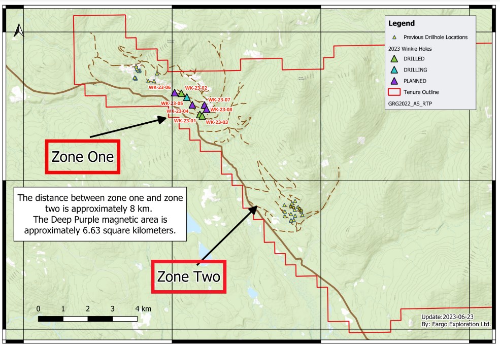
Since the later stages of 2021, the company has implemented drilling initiatives at numerous points over almost 10 kilometers of the 14-kilometer stretch known as the Deep Purple magnetic anomaly. The XRF data for all these holes indicates deposits of nickel, magnesium, cobalt, and chromium beginning from the bedrock surface and extending into the depths. Subsequent assays performed on select drill holes have corroborated the mineralization commencement from the surface.
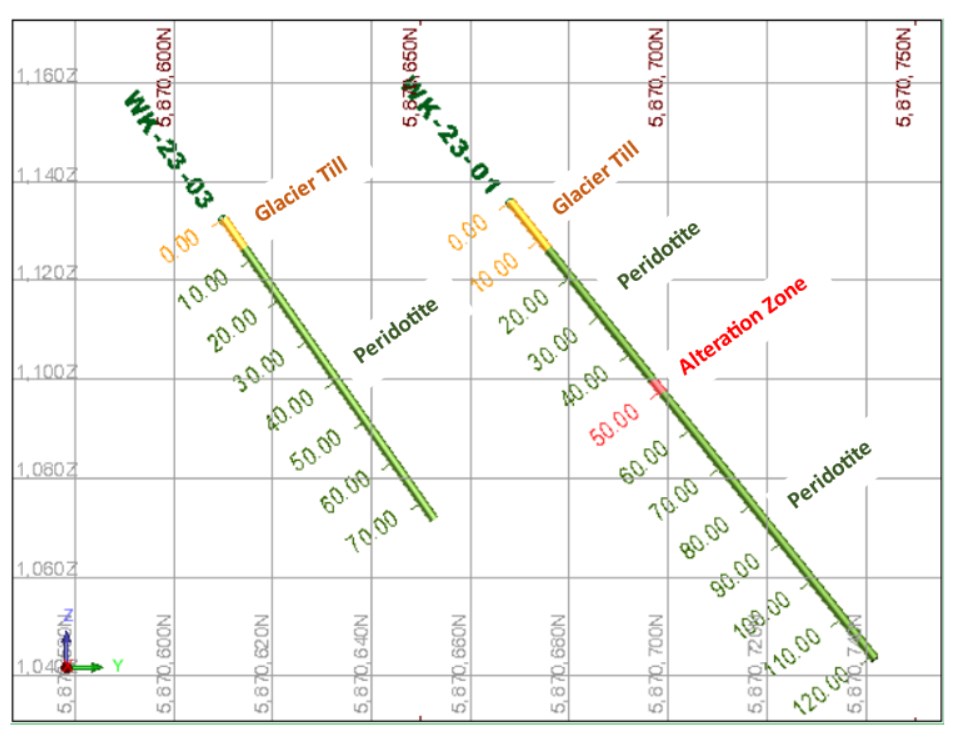
The first assay results of the 2023 drilling season have been shared by Green River Gold Corp. These findings pertain to drill hole WK-23-01, which was initially announced in a press release dated June 12, 2023. The hole was drilled to a total depth of 120.9 meters, revealing mineralization findings for nickel, cobalt, chromium, and magnesium. The mineral concentrations align with the findings from the 42 holes drilled during late 2021 and throughout 2022.
The assay data revealed a unique and notable serpentine alteration zone within WK-23-01. Starting from the depth of 47.4 meters to 50.8 meters, strong serpentinization was identified. The MSA laboratory in Langley, BC conducted an analysis of samples from this zone, which disclosed average contents of 0.187% nickel, 0.009% cobalt, 0.0963% chromium, and 20.8% magnesium. Moreover, substantial amounts of zinc (0.758%), lead (0.434%), silver (5.3 ppm), and significant gold (0.158 ppm) were discovered in the central section of the altered zone, between 48.3 meters and 48.9 meters, which attests to the presence of high-grade silver, lead, and zinc, along with appreciable amounts of gold.
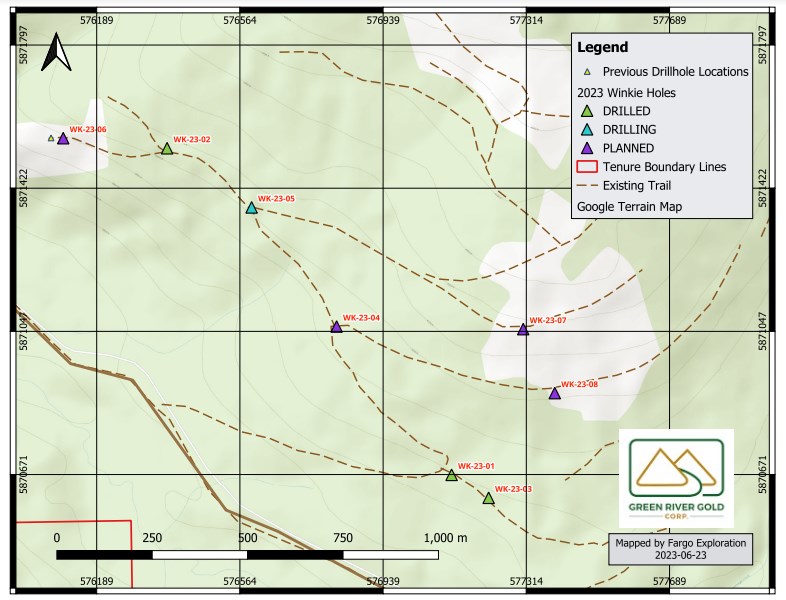
Another development involves the drilling of hole WK-23-03, performed using a Winkie drill. This operation aimed to ascertain the continuity of the mineralization further along the Deep Purple magnetic anomaly. The extracted core from the surface to a depth of 74.37 meters was scrutinized with an XRF Analyzer and yielded an average of 0.166% nickel, 0.0138% cobalt, 0.160% chromium, and 19.32% magnesium. The mineral data for these elements correspond with the results of prior analyses conducted on the earlier 44 drill holes.
Currently, drilling for hole WK-23-05 is underway. Once the core is extracted, it will be sent to the company’s Quesnel facility for an XRF scan. Green River Gold Corp. plans to drill an additional 600 meters across 8 Winkie diamond drill holes as part of the ongoing phase, continuing the efforts of the 2022 drilling program.
The second stage of this year’s drilling plan also includes 20 planned NQ diamond drill holes, part of a 6,000-meter program to test at depths down to 300 meters and expand on the 14-kilometer strike length around and between Zone 1 and Zone 2. The 2023 program also entails further exploration groundwork at the newly enlarged Fontaine Gold Project. This will involve bedrock mapping, soil and rock sampling, and a geophysical program, with more detailed plans to be announced upon finalization.
The above references an opinion and is for information purposes only. It is not intended to be investment advice. Seek a licensed professional for investment advice. The author is not an insider or shareholder of any of the companies mentioned above.
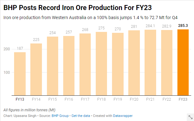
BHP (ASX:BHP) has announced a record high in its annual iron ore production, bolstered by steady operations at its South Flank mine in Western Australia. However, the company has noted that it is preparing for higher operational costs.
BHP also reaffirmed that production at South Flank would reach full capacity of 80 million metric tons per annum, on a 100% basis, by the end of fiscal 2024. Iron ore production was augmented by an improved rail performance at the mines in Western Australia, albeit the company did experience a slight setback due to adverse weather conditions from tropical Cyclone Ilsa in the quarter.
Iron ore output from Western Australia was reported to be 72.7 million metric tons (Mt) in the three months leading up to June 30. Although impressive, this number fell slightly short of Visible Alpha estimates of 73 Mt, according to UBS.
BHP, the world’s leading miner by market capitalization, disclosed that unit costs at its Western Australian iron ore operations, along with its Chilean copper mine, Escondida, are likely to reach the higher end of predicted ranges. Despite this, capital and exploration expenditure is set to be below the annual guidance due to foreign exchange fluctuations.
BHP also release an exciting forecast for fiscal 2024, predicting an iron ore output of between 282 and 294 million metric tons from Western Australia. The mid-point forecast shows a 0.9% increase over the annual production of 285.3 million metric tons for fiscal 2023.
The company highlighted a boost in copper production, following its $6.4 billion acquisition of OZ Minerals in May. Copper production rose by 9% to 1,716.5 thousand metric tons in the fiscal year, and the outlook for fiscal 2024 is promising, with production estimated between 1,720 and 1,910 thousand metric tons.
This surge in copper production is largely attributable to the anticipated higher grades at the world’s top copper mine and the successful integration of OZ Minerals into BHP’s South Australian operations.
The above references an opinion and is for information purposes only. It is not intended to be investment advice. Seek a licensed professional for investment advice. The author is not an insider or shareholder of any of the companies mentioned above.
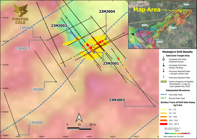
FireFox Gold (TSXV:FFOX) has continued to make progress on its core drilling campaign at its wholly-owned Mustajärvi Gold Project in Lapland, Finland. The company reported findings from the initial four drill holes 23MJ001, 23MJ002, 23MJ003, and 23MJ004, all drilled at the East Target. Each hole showed several key intervals of gold mineralization, extending the mineralized region to the northwest, southwest, southeast, and downdip. These holes were tested and all showed assays exceeding 10.0 g/t of gold.
Carl Lofberg, FireFox’s CEO, commented in a press release: “The drill results from Mustajärvi continue to reveal thicker replacement-style gold mineralization that is very near surface. These four holes have filled in some gaps in the heart of the East Target and confirmed an expansion of the system to the south with a 120m step out hole. These results also confirm the presence of at least two directions of controlling structures – the main lode has been confirmed as plunging to the southwest and deeper high-grade intercepts reinforce the importance of the northeast trending vein system. We have much more data on the way, as results from the final four holes of this drill program are still pending and our team has commenced a trenching program at Mustajärvi East.”
The Mustajärvi Project, still in its early stages, is situated on the highway connecting the cities of Kittilä and Sodankylä, around 17 kilometers to the east of Kittilä. To date, FireFox and its predecessor companies have drilled roughly 14,158 meters. The drilling process has demarcated three separate lodes of gold mineralization along a stretch exceeding 1.5 kilometers so far. Recently, the company has shifted its focus more towards the East Target due to its high-grade nature close to the surface. Figure 1 reveals the traces of the recent drill holes and mineralization at the East Target relative to previous drilling and ground magnetic data.
As noted in a press release dated June 14, 2023, the spring 2023 drilling program at Mustajärvi aimed to fill certain gaps in the drilling and to probe extensions to the south, west, and southwest. The initial four holes from this program have enhanced the understanding of the high-grade core of the East Target, and have established control of a crucial fault on the south side of the deposit, which is now confirmed as mineralized.
The findings from drill holes 23MJ001 and 23MJ002 are especially significant. Both were drilled in a scissors-like fashion along a northwest-southeast fence. These holes were designed to test the western side of the shallow high-grade replacement style mineralization and to look for downdip extensions of the Riedel veins known to frequently host high-grade gold.
The results from these first four holes from the spring 2023 drilling program have been encouraging. Further insights from these holes, along with continued drilling efforts, are expected to provide a better understanding of the potential value of the Mustajärvi Gold Project, and will help FireFox in shaping its future exploration strategies.
Highlights from the results are as follows:
- 23MJ001
- 11.95m averaging 9.69 g/t Au from 5.4 metres down hole (includes 0.3 metres of core loss);
- including 0.75m at 94.50 g/t Au; and
- 5.35m averaging 8.09 g/t Au from 37.25 metres down hole;
- including 0.85 m at 28.87 g/t Au.
- 11.95m averaging 9.69 g/t Au from 5.4 metres down hole (includes 0.3 metres of core loss);
- 23MJ002
- 7.35 m averaging 2.40 g/t Au from 60.0 metres down hole;
- including 1.0 meter at 10.51 g/t Au; and
- 9.00 m averaging 1.06 g/ Au from 103.0 metres down hole.
- 7.35 m averaging 2.40 g/t Au from 60.0 metres down hole;
- 23MJ003
- 9.50 m averaging 2.08 g/t Au from 155.5 metres down hole;
- 2.45 m averaging 15.22 g/t Au from 248.65 meters down hole;
- including 1.45m at 24.16 g/t Au.
- 23MJ004
- 20.45 m averaging at 5.14 g/t Au from 12.0 metres down hole;
- including 0.75 m at 23.92 g/t Au;
- including 3.15 m at 13.69 g/t Au;
- including 0.9 m at 20.83 g/t Au; and
- 14.8 m averaging 6.00 g/t Au from 54.0 metres down hole;
- including 3.45 m at 19.43 g/t Au , which includes 1.55 m at 34.72 g/t Au.
- 20.45 m averaging at 5.14 g/t Au from 12.0 metres down hole;
Table 1: Significant Drill Intercepts in Drillholes 23MJ001 – 23MJ004
Cutoff Grade 0.5 g/t Au
| Drill Hole | From (m) | To (m) | Interval (m) | Au Grade** (g/t) | |
| 23MJ001 | 5.40 | 17.35 | 11.95* | 9.69 | |
| Including | 5.40 | 7.00 | 1.60 | 15.93 | |
| Including | 11.00 | 17.35 | 6.35 | 14.02 | |
| Which includes | 15.90 | 16.65 | 0.75 | 94.50 | |
| 28.55 | 29.25 | 0.70 | 4.41 | ||
| 30.80 | 31.80 | 1.00 | 1.05 | ||
| 37.25 | 42.60 | 5.35 | 8.09 | ||
| Including | 37.25 | 38.10 | 0.85 | 28.87 | |
| Including | 41.70 | 42.60 | 0.90 | 19.97 | |
| 50.00 | 51.00 | 1.00 | 3.59 | ||
| 171.00 | 171.80 | 0.80 | 1.23 | ||
| 23MJ002 | 33.00 | 34.00 | 1.00 | 1.84 | |
| 38.00 | 41.00 | 3.00 | 0.56 | ||
| 60.00 | 67.35 | 7.35 | 2.40 | ||
| Including | 61.00 | 62.00 | 1.00 | 10.51 | |
| 70.00 | 71.00 | 1.00 | 3.67 | ||
| 77.00 | 78.00 | 1.00 | 3.59 | ||
| 96.00 | 98.00 | 2.00 | 0.76 | ||
| 103.00 | 112.00 | 9.00 | 1.06 | ||
| Including | 106.80 | 107.80 | 1.00 | 4.33 | |
| 114.00 | 115.00 | 1.00 | 0.76 | ||
| 122.00 | 123.00 | 1.00 | 3.43 | ||
| 127.00 | 128.00 | 1.00 | 0.59 | ||
| 23MJ003 | 155.50 | 165.00 | 9.50 | 2.08 | |
| Including | 158.50 | 159.50 | 1.00 | 8.63 | |
| Including | 164.00 | 165.00 | 1.00 | 6.60 | |
| 171.00 | 171.70 | 0.70 | 2.24 | ||
| 203.60 | 204.60 | 1.00 | 1.27 | ||
| 208.50 | 209.50 | 1.00 | 2.01 | ||
| 211.60 | 212.60 | 1.00 | 1.72 | ||
| 223.90 | 224.90 | 1.00 | 1.34 | ||
| 248.65 | 251.10 | 2.45 | 15.22 | ||
| Including | 248.65 | 250.10 | 1.45 | 24.16 | |
| 268.60 | 269.30 | 0.70 | 0.92 | ||
| 23MJ004 | 12.00 | 32.45 | 20.45 | 5.14 | |
| Including | 14.50 | 15.25 | 0.75 | 23.92 | |
| Including | 21.60 | 24.75 | 3.15 | 13.69 | |
| Also includes | 24.05 | 24.75 | 0.70 | 28.00 | |
| Including | 27.10 | 32.45 | 3.70 | 6.91 | |
| Also includes | 27.10 | 28.00 | 0.90 | 20.83 | |
| Also includes | 31.80 | 32.45 | 0.65 | 15.97 | |
| 45.60 | 50.00 | 4.40 | 0.79 | ||
| 54.00 | 68.80 | 14.80 | 6.00 | ||
| Including | 55.90 | 59.35 | 3.45 | 19.43 | |
| 57.80 | 59.35 | 1.55 | 34.72 | ||
| Including | 65.50 | 66.20 | 0.70 | 12.83 | |
| 89.00 | 93.90 | 4.90 | 4.70 | ||
| including | 91.50 | 93.90 | 2.40 | 8.83 | |
| 114.00 | 115.00 | 1.00 | 0.76 | ||
| 123.20 | 126.70 | 3.50 | 0.98 | ||
| 152.00 | 153.00 | 1.00 | 1.15 | ||
| 171.00 | 171.95 | 0.95 | 2.46 | ||
| 174.60 | 175.50 | 0.90 | 4.25 | ||
| Drilling is believed to be perpendicular to the dip of the mineralization, however true widths are not yet known and will be confirmed with additional drilling and geologic modelling. * Intercept includes 0.3 m of core loss. The lost interval was assigned a grade of 0.0 g/t Au for all calculations. ** Au grades uncapped. |
|||||
Table 2: Mustajärvi Drilling 2023 Collar Information (coordinates presented in EPSG:3067)
| Drill Hole | Easting | Northing | Azimuth (°) | Plunge (°) | Final Depth (m) |
| 23MJ001 | 429085.4 | 7501026 | 320 | 60 | 188 |
| 23MJ002 | 429037.1 | 7501068 | 140 | 50 | 151.7 |
| 23MJ003 | 429214 | 7500912 | 320 | 60 | 284 |
| 23MJ004 | 429111 | 7501055 | 240 | 50 | 175.4 |
The above references an opinion and is for information purposes only. It is not intended to be investment advice. Seek a licensed professional for investment advice. The author is not an insider or shareholder of any of the companies mentioned above.
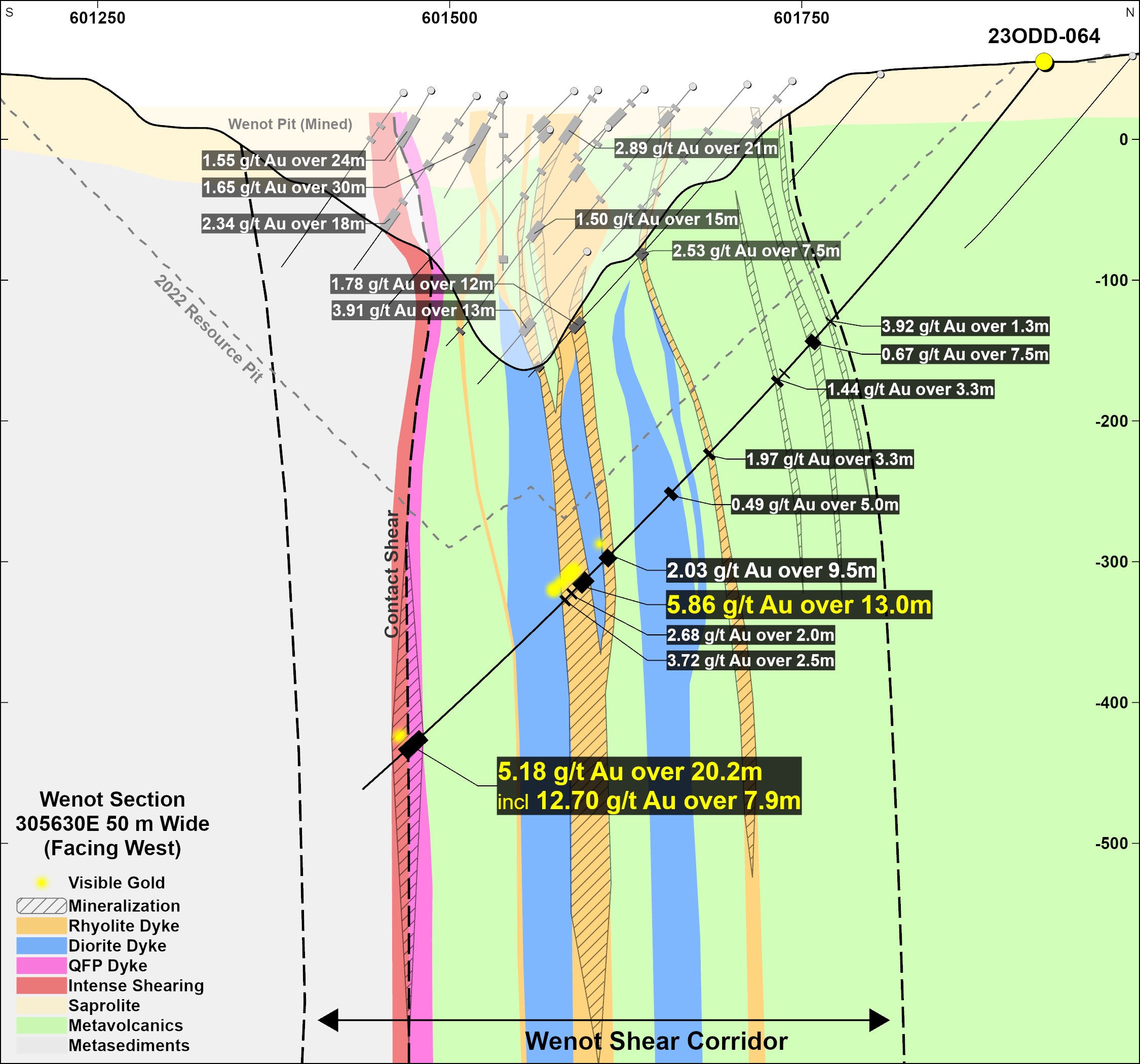
Omai Gold Mines (TSXV:OMG) has reported the results of further drilling operations at their gold project based in Omai, Guyana. The report covers five additional holes, including four for exploratory purposes and one specifically at Wenot, focusing on exploring both the deeper extensions of the central portion of the known deposit as well as the additional, shallower, northern gold zones.
Elaine Ellingham, President & CEO, commented in a press release: “Similar to our excellent drill results from a couple of weeks ago, these new results again confirm the significant expansion potential for the Wenot deposit, to depth as well as along the flanks. Hole 23ODD-063 results previously released show a very wide 42-75 m zone of gold mineralization at the west end of the deposit, from a 110m to 290 metre depth, with evidence it extends to surface. Hole 23ODD-064 is located 1.25 kilometres east of hole 063, again demonstrating the continuity of the multiple shear-hosted gold zones that extend along a minimum 2.5 km strike.”
“In the first half of the year, we pursued some of the nearby exploration targets and we remain confident that there are additional gold deposits on this well endowed Omai gold property. However, given the large NI 43-101 Mineral Resource Estimate1 established late last year, we believe our drill budget is best focused on: 1) testing some of the undrilled gaps within the Wenot deposit model, 2) expanding the western “starter pit” area, and 3) providing evidence of the blue-sky potential for the Wenot deposit at depth. Results to date are already expected to positively impact the resources as we move forward to an updated mineral resource estimate to be followed by a decision on a preliminary economic assessment (“PEA”) later this year.”
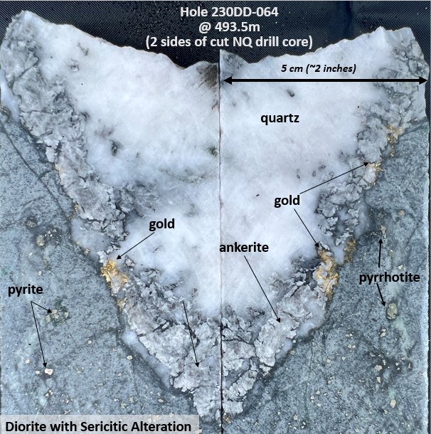
The project’s progress this year is impressive, with eleven holes totalling 3,570 metres being completed so far in 2023. An interesting highlight includes Hole 23ODD-064, which establishes the consistency of the gold-bearing structures at Wenot at least 100m below the current resource model. Its notable intersection suggests that the Wenot gold grades tend to increase with depth.
The mineralization at the Wenot deposit, as evidenced by Hole 23ODD-064, is typical of the location. Gold mineralization was visible in 19 distinct locations along the core and was usually found within quartz veining and adjacent alteration halos.
Regrettably, due to the sheer width of the shear, a single drill hole at the targeted depths makes it challenging to drill across the entire width. This suggests that untested additional zones may still exist within the southern sedimentary rocks.
The gold zones in the three drill holes correlate well with each other, and the higher grade and wider gold zones found in holes 23ODD-063 and 12ODD-064 are expected to contribute positively to the next updated Mineral Resource Estimate for Wenot.
Results from four more exploration holes have also been received. Hole 23ODD-059, while encountering brecciated volcanics with silicification and alteration, did not yield any anomalous gold. Meanwhile, holes 23ODD-060 and 061 on Broccoli Hill found several narrow gold-bearing quartz veinlets. The large size of Broccoli Hill suggests that these holes may not have fully tapped into the potential of the area.
The Brother gold target was tested by single Hole 23ODD-062 but did not yield significant gold findings. Another Hole 23ODD-065 was completed in Wenot’s western area, with sampling in progress, and hole 23ODD-066 has begun. The company currently has a cash position of over $2 million, sufficient to complete the planned drilling and the updated mineral resource planned for later this year.
Highlights from the results are as follows:
- 5.18 g/t Au over 20.2 m (including 12.7 g/t Au over 7.9 m)
- 5.86 g/t Au over 13.0 m
- 2.03 g/t over 9.5m
- 1.77 g/t over 9.1 m
Table 1. Drill Results for Holes 23ODD-59 to 23ODD-62 and 23ODD-64
| From | To | Gold g/t | metres | |
| 23ODD-059 | no significant results | |||
| 23ODD-060 | 55.5 | 57.0 | 5.63 | 1.5 |
| 23ODD-061 | 110.0 | 110.3 | 7.16 | 0.3 |
| 155.9 | 156.9 | 0.35 | 1.0 | |
| 255.4 | 258.8 | 0.35 | 3.4 | |
| 23ODD-062 | no significant results | |||
| 23ODD-064 | 239.0 | 240.3 | 3.92 | 1.3 |
| 255.0 | 262.5 | 0.67 | 7.5 | |
| 288.3 | 289.5 | 0.70 | 1.2 | |
| 294.9 | 298.2 | 1.44 | 3.3 | |
| 365.7 | 369.0 | 1.97 | 3.3 | |
| 404.0 | 409.0 | 0.49 | 5.0 | |
| 466.0 | 475.5 | 2.03 | 9.5 | |
| 489.0 | 502.0 | 5.86 | 13.0 | |
| 506.0 | 508.0 | 2.68 | 2.0 | |
| 512.5 | 515.0 | 3.72 | 2.5 | |
| 557.6 | 566.7 | 1.77 | 9.1 | |
| 655.0 | 675.2 | 5.18 | 20.2 | |
| includes | 667.3 | 675.2 | 12.70 | 7.9 |
**True widths vary as mineralization at Wenot is generally hosted within stockwork vein systems with alteration halos, with an estimated true width range of 70-90%. Cut off grade 0.30 g/t Au with maximum 4m internal dilution.
The above references an opinion and is for information purposes only. It is not intended to be investment advice. Seek a licensed professional for investment advice. The author is not an insider or shareholder of any of the companies mentioned above.
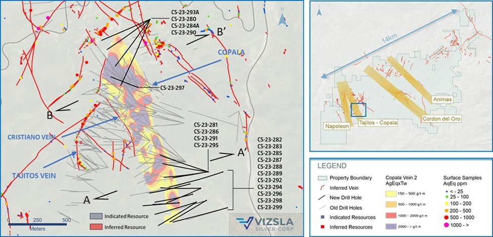
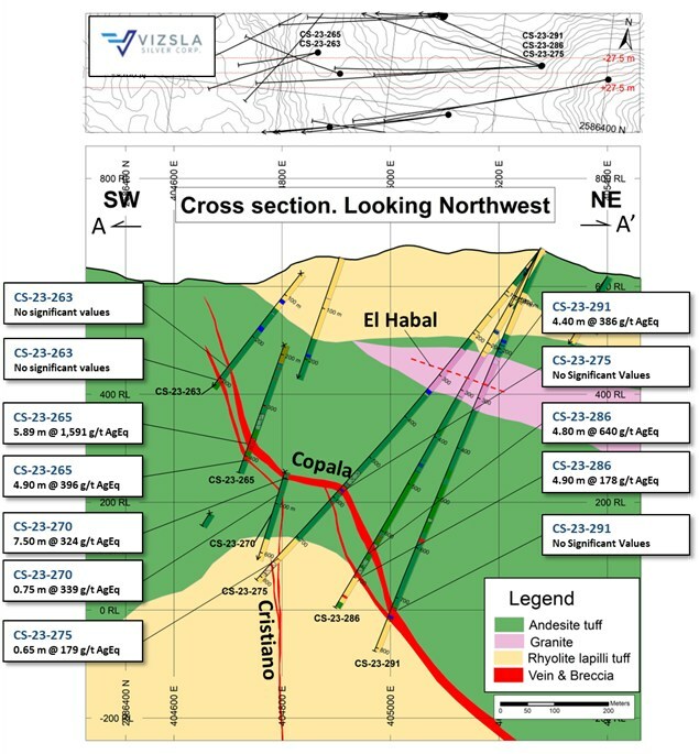
Vizsla Silver (TSXV:VZLA) has disclosed new findings from 20 exploratory drillings at its fully owned, mainstay Panuco silver-gold project, found in Mexico. These results broaden the known mineral-rich areas of the Copala resource area, reaching approximately 370 meters southeast and about 50 meters north.
Michael Konnert, President & CEO of Vizsla, commented in a press release: “Expansion drilling at Copala, both to the southeast and north, continue to highlight a robust precious metals structure well beyond the January 2023 resource boundary. The overall strike length now measures approximately 1,670 metres long and remains open in both directions. Additionally, drilling has expanded the high-grade Copala 2 vein situated between Tajitos and Copala main and identified a new near-surface structure called ‘El Habal‘. Moving forward, we will continue to both expand and infill these high-grade zones with three drill rigs in preparation for an updated resource estimate planned for the fourth quarter of 2023. Q4/23.”
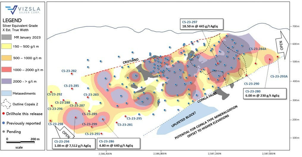
The Copala Structure, which predominantly contains precious metals, lies about 800 meters east of the Napoleon Structure in the western segment of the Panuco district. Currently, the indicated resources within the Copala Structure are at 51.1 Moz AgEq with a density of 516 g/t AgEq, and inferred resources at 55.4 Moz AgEq with a density of 617 g/t AgEq. These resources are housed in a large vein-breccia interlayered with host rock, reaching thicknesses up to 82 meters. Vizsla’s geologists suggest that the average dip of the Copala is roughly 46 degrees eastward, varying from 35 degrees in the north to about 52 degrees in the south.
With continuous drilling, mineralization in the Copala Structure has been traced for about 1,670 meters horizontally and approximately 400 meters vertically. The southeast and north regions remain open for high-grade silver-gold mineralization. The recent expansion drillings, consisting of 15 holes in the southern part of Copala and five in the north, targeted the main Copala structure and the Copala 2 vein. Findings show that the Copala structure extends southeastward beyond the initial resource assessment in January 2023. Vizsla aims to perform infill drillings to test and expand high-grade zones identified in the southeast.
The Copala 2 vein, situated at the footwall of the main Copala, is bounded up-dip by Copala, west by Tajitos, and east by the Copala Fault. It has a northeast strike and a southeast dip of roughly 48 degrees, and has been traced for approximately 330 meters horizontally and 290 meters vertically. The company’s previous results from the Copala 2 vein were released on May 19, 2022.
Vizsla geologists have discovered a new near-surface structure named “El Habal” in the southeast with hole CS-23-291. The team is currently re-examining and sampling other holes in the area to understand this newly identified structure.
So far, Vizsla has completed approximately 55,000 meters of its fully funded 90,000-meter drilling program for 2023.
The Panuco project, situated near the city of Mazatlán in southern Sinaloa, Mexico, is a newly consolidated, high-grade discovery encompassing a 7,189.5-hectare, previously producing district. It features more than 86 kilometers of total vein length, 35 kilometers of underground mines, roads, power, and permits.
These deposits, which are mostly silver and gold, originate from siliceous volcanism and crustal extension during the Oligocene and Miocene eras. The deposits lie within continental volcanic rocks correlated to the Tarahumara Formation.
As of a technical report filed on March 10, 2023, the Panuco Project was estimated to contain an in-situ indicated mineral resource of 104.8 Moz AgEq and an in-situ inferred resource of 114.1 Moz AgEq.
Highlights from the results are as follows:
- CS-23-297 returned 445 grams per tonne (g/t) silver equivalent (AgEq) over 18.50 metres true width (mTW) (310 g/t silver and 2.32 g/t gold)
- CS-23-290 returned 760 g/t AgEq over 5.05 mTW (565 g/t silver and 3.48 g/t gold)
- Including 3,469 g/t AgEq over 1.00 mTW (2,838 g/t silver and 12.29 g/t gold)
- CS-23-286 returned 640 g/t AgEq over 4.80 mTW (417 g/t silver and 3.74 g/t gold)
- Including 2,568 g/t AgEq over 0.68 mTW (1,585 g/t silver and 16.20 g/t gold)
- CS-23-294 returned 7,512 g/t AgEq over 1.00 mTW (6,880 g/t silver and 16.50 g/t gold)
Table 1: Downhole drill intersections from the holes reported for Copala structure and Cristiano vein.
|
Drillhole |
From |
To |
Downhole Length |
Estimated True width |
Ag |
Au |
AgEq |
Vein |
|
|
(m) |
(m) |
(m) |
(m) |
(g/t) |
(g/t) |
(g/t) |
|||
|
CS-23-280 |
353.55 |
355.00 |
1.45 |
1.27 |
1,240 |
3.64 |
1,399 |
Copala |
|
|
CS-23-281 |
789.50 |
790.60 |
1.10 |
0.80 |
57 |
26.40 |
1,835 |
Copala 3 |
|
|
CS-23-282 |
No Significant Values |
Copala |
|||||||
|
CS-23-283 |
552.20 |
553.60 |
1.40 |
1.07 |
279 |
0.50 |
293 |
Cristiano |
|
|
CS-23-284A |
No Significant Values |
Copala |
|||||||
|
CS-23-285 |
No Significant Values |
Copala |
|||||||
|
CS-23-285 |
418.10 |
419.35 |
1.25 |
0.78 |
335 |
1.77 |
431 |
Cristiano |
|
|
CS-23-286 |
639.50 |
645.85 |
6.35 |
4.80 |
417 |
3.74 |
640 |
Copala |
|
|
Includes |
643.50 |
644.40 |
0.90 |
0.68 |
1,585 |
16.20 |
2,568 |
||
|
CS-23-286 |
691.50 |
698.50 |
7.00 |
4.90 |
160 |
0.44 |
178 |
Copala 3 |
|
|
CS-23-287 |
No Significant Values |
Copala |
|||||||
|
CS-23-288 |
No Significant Values |
Copala |
|||||||
|
CS-23-289 |
No Significant Values |
Copala |
|||||||
|
CS-23-290 |
No Significant Values |
Copala |
|||||||
|
CS-23-290 |
557.80 |
588.70 |
30.90 |
5.05 |
565 |
3.48 |
760 |
Copala 2 |
|
|
Includes |
557.80 |
563.95 |
6.15 |
1.00 |
2,838 |
12.29 |
3,469 |
||
|
CS-23-291 |
265.50 |
270.00 |
4.50 |
4.40 |
145 |
3.72 |
386 |
El Habal |
|
|
CS-23-291 |
No Significant Values |
Copala |
|||||||
|
CS-23-292 |
458.45 |
459.30 |
0.85 |
0.79 |
239 |
1.51 |
324 |
Copala |
|
|
CS-23-293A |
No Significant Values |
Copala |
|||||||
|
CS-23-294 |
561.70 |
562.80 |
1.10 |
1.00 |
6,880 |
16.50 |
7,512 |
Copala |
|
|
CS-23-295 |
No Significant Values |
Copala |
|||||||
|
CS-23-296 |
No Significant Values |
Copala |
|||||||
|
CS-23-297 |
140.45 |
159.35 |
18.90 |
18.50 |
310 |
2.32 |
445 |
Copala |
|
|
CS-23-297 |
290.00 |
294.00 |
4.00 |
3.65 |
244 |
1.77 |
347 |
Copala 2 |
|
|
CS-23-298 |
631.60 |
633.50 |
1.90 |
1.83 |
212 |
1.14 |
274 |
Copala |
|
|
CS-23-299 |
694.75 |
695.75 |
1.00 |
0.90 |
972 |
3.36 |
1,131 |
Copala |
|
|
Note: AgEq = Ag g/t x Ag rec. + (Au g/t x Au Rec x Au price/gram)/Ag price/gram. Metal price assumptions are $24.00/oz silver and $1,800/oz gold and metallurgical recoveries assumed are 93% for silver and 90% for gold. Gold and silver metallurgical recoveries used in this release are from metallurgical test results of the Napoleon vein (see press release dated February 17, 2022). |
Table 2: Drillhole details for the reported drillholes. Coordinates in WGS84, Zone 13.
|
Drillhole |
Easting |
Northing |
Elevation |
Azimuth |
Dip |
Depth |
|
CS-23-280 |
404,775 |
2,587,802 |
572 |
234.7 |
-28 |
498 |
|
CS-23-281 |
405,277 |
2,586,491 |
677 |
278.3 |
-61.2 |
811.5 |
|
CS-23-282 |
405,025 |
2,586,223 |
641 |
265.5 |
-45.3 |
444 |
|
CS-23-283 |
405,119 |
2,586,386 |
646 |
258 |
-59.5 |
670.5 |
|
CS-23-284A |
404,775 |
2,587,801 |
572 |
217 |
-26 |
543 |
|
CS-23-285 |
405,025 |
2,586,224 |
641 |
266.5 |
-63.5 |
504 |
|
CS-23-286 |
405,276 |
2,586,491 |
677 |
261 |
-60 |
766.5 |
|
CS-23-287 |
405,141 |
2,586,298 |
645 |
256.1 |
-62.9 |
700.5 |
|
CS-23-288 |
405,174 |
2,586,229 |
656 |
254 |
-58 |
702 |
|
CS-23-289 |
405,211 |
2,586,349 |
661 |
270 |
-62 |
714 |
|
CS-23-290 |
404,776 |
2,587,801 |
572 |
202 |
-25 |
688.5 |
|
CS-23-291 |
405,276 |
2,586,491 |
677 |
261.8 |
-66.6 |
807 |
|
CS-23-292 |
405,174 |
2,586,229 |
656 |
239.6 |
-47.7 |
570 |
|
CS-23-293A |
404,775 |
2,587,802 |
572 |
246 |
-26 |
505.5 |
|
CS-23-294 |
405,210 |
2,586,347 |
648 |
246 |
-64.5 |
735 |
|
CS-23-295 |
405,276 |
2,586,491 |
677 |
288.3 |
-56 |
784.5 |
|
CS-23-296 |
405,261 |
2,586,245 |
665 |
239.7 |
-52.7 |
600 |
|
CS-23-297 |
404,674 |
2,587,217 |
533 |
290 |
-53 |
412.5 |
|
CS-23-298 |
405,440 |
2,586,181 |
629 |
255 |
-49 |
753 |
|
CS-23-299 |
405,401 |
2,586,489 |
618 |
252.3 |
-53.4 |
793.5 |
The above references an opinion and is for information purposes only. It is not intended to be investment advice. Seek a licensed professional for investment advice. The author is not an insider or shareholder of any of the companies mentioned above.
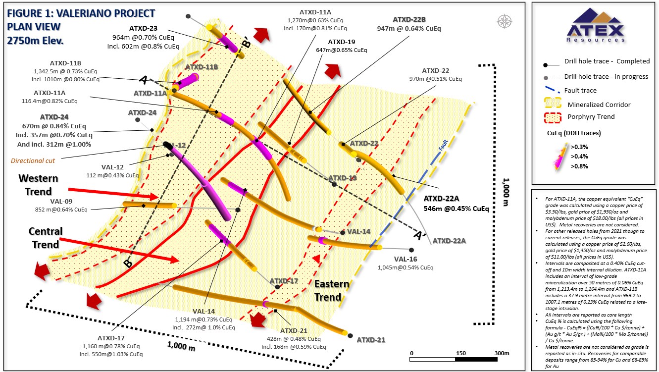
Atex Resources Inc. (TSXV:ATX) has shared the partial assay results for the final two drill holes, labelled as ATXD-24 and ATXD-22B, of its Phase III drill program at the Valeriano Copper-Gold Project in the Atacama Region, Chile.
Raymond Jannas, President, and CEO of ATEX, commented in a press release: “This is a great way to finish the Phase III program and has us excited to restart drilling in the fall and continue where we left off with Phase III. Hole ATXD-24 is a very significant hole as it intersected Early Porphyry further west than anticipated demonstrating that the Central Trend is wider than anticipated in this area. We look forward to completing this hole in the fall and are especially excited to follow up and test the continuity of this wider part of the Central Trend.”
Drill hole ATXD-24, was positioned towards the southeast across the eastern boundary of the Western trend and angled towards the Central Trend. The hole’s incline was adjusted using directional drilling tools to engage the Central Trend more efficiently. In an interval between 1,050 and 1,173 metres, three separate runs were performed with the directional tool. A partial core recovery within this segment was achieved. Notably, mineralization grading above 0.40% CuEq commenced above this segment, from 964 metres to the top of the directional cut at 1,050 metres. This interval produced 86.0 metres of 0.45% CuEq (0.34% Cu, 0.1 g/t Au, and 70 ppm Mo).
ATXD-22B, the other drill hole, was temporarily halted at the program’s completion. It featured potassic altered, chalcopyrite bearing RMB, and included visible chalcopyrite and bornite mineralization zones. The drilling of this hole will resume in Phase IV.
The Phase III program began in October 2022 and concluded in late May 2023, resulting in a total of 12,513 metres of drilling, distributed among eight holes, with four originating from the surface and four more from pre-existing holes.
Notably, Phase III marked a series of execution milestones for the project, including the completion of the deepest drill hole to date (ATXD-11B, reaching 2,190.5 metres), and a 100% completion rate on drill holes. The use of directional drilling led to an approximate saving of 3,000 metres of surface drilling. Phase IV, scheduled to begin in October 2023, is intended to build on Phase III’s success.
Looking ahead, Atex plans to use the Phase III data to revise the copper-gold mineral resource statement for the Valeriano Project and to generate an updated NI-43 101 compliant technical report. Furthermore, metallurgical tests using core samples from the Phase III program are being conducted by Atex in collaboration with Libertas Metallurgy and Base Met Labs of Kamloops BC, with completion expected by Q3.
Highlights from the results are as follows:
- ATXD-24 intersected 670 metres of 0.84% Copper Equivalent “CuEq” (0.60% Cu, 0.24 g/t Au & 101 ppm Mo) including,
- 312 metres of 1.00% CuEq (0.50% Cu, 0.37 g/t Au and 11 ppm Mo), in Early Porphyry within the Central Trend, from 1,530 metres to where the hole was paused at a depth of 1,842.4 metres at the end of the drill season (Figure 1).
- The high-grade, Early Porphyry was intersected earlier in the hole than anticipated, widening the Central Trend by approximately 70 metres to the west.
- ATXD-24 was planned to reach 2,200 metres in depth and will be completed as part of the Phase IV drill program.
- ATXD-22B intersected 947 metres of 0.64% CuEq (0.49% Cu, 0.15 g/t Au and 74 ppm Mo) in mineralized rock milled breccia “RMB” from 668 metres to the bottom of the hole at 1,615 metres.
- ATXD-22B ended in mineralization and with the grade improving towards the bottom of the hole. The hole was planned to reach a depth of 2,100 metres and will be completed as part of the Phase IV program.
Table 1. ATXD-24 and ATXD-22B Results
| Hole ID | From | To | Interval (2) (3) | Cu | Au | Mo | CuEq(1) |
| (metres) | (metres) | (metres) | % | g/t | ppm | % | |
| ATXD-24* | 1,173.0 | 1,842.4 | 670.0 | 0.60 | 0.24 | 101 | 0.84 |
| incl. | 1,173.0 | 1,530.0 | 357.0 | 0.50 | 0.18 | 121 | 0.70 |
| incl. | 1,530.0 | 1,842.4 | 312.4 | 0.73 | 0.30 | 77 | 1.00 |
| ATXD-22B* | 668.0 | 1,615.1 | 947.1 | 0.49 | 0.15 | 74 | 0.64 |
- The CuEq grade was calculated using a copper price of $2.60/lb, gold price of $1,450/oz and molybdenum price of $11.00/lb (all prices in US$). Metal recoveries are not considered as grade is reported as in-situ. Recoveries for comparable deposits range from 85-94% for Cu and 68-85% for Au. CuEq is calculated using the following formula – CuEq% = ((Cu%/100 * Cu $/tonne) + (Au g/t * Au $/gr.) + (Mo%/100 * Mo $/tonne)) / Cu $/tonne.
- Intervals are composited at a 0.40% CuEq cut-off and unless otherwise stated a maximum of 10 metres of internal dilution.
- All intervals are reported as core lengths as the true lengths of the intervals are unknown at this time.
Table 2. Phase III Results Summary
| Hole ID** | From | To | Interval2 | Cu | Au | Mo | Cu Eq | Hole Length and Objective |
| (metres) | (metres) | (metres) | (%) | (g/t) | (ppm) | (%) | ||
| ATXD-11A | 860.0 | 2,130.0 | 1,270.0 | 0.43 | 0.21 | 52 | 0.63 | 2,130 m – daughter from VALDD-11. Tested Western and Central Trends |
| incl. | 1,048.0 | 1,213.4 | 165.4 | 0.51 | 0.2 | 105 | 0.73 | |
| and | 1,376.0 | 1,492.4 | 116.4 | 0.56 | 0.3 | 95 | 0.82 | |
| Incl. | 1,376.0 | 1,393.3 | 17.3 | 0.73 | 0.3 | 39 | 1.01 | |
| and incl. | 1,450.0 | 1,470.0 | 20.0 | 0.64 | 0.3 | 308 | 1.06 | |
| and | 1,698.0 | 2,130.1 | 432.1 | 0.48 | 0.3 | 12 | 0.71 | |
| incl. | 1,698.0 | 1,868.0 | 170.0 | 0.54 | 0.3 | 11 | 0.81 | |
| also incl. | 1,730.0 | 1,752.0 | 22.0 | 0.66 | 0.4 | 11 | 0.95 | |
| and | 1,816.7 | 1,836.0 | 19.3 | 0.56 | 0.5 | 10 | 0.94 | |
| and | 1,854.0 | 1,868.0 | 14.0 | 0.6 | 0.5 | 11 | 1.00 | |
| and | 2,100.0 | 2,130.1 | 30.1 | 0.53 | 0.2 | 19 | 0.73 | |
| ATXD-21 | 846.0 | 1,274.0 | 428.0 | 0.31 | 0.2 | 56 | 0.48 | 1,838 m – Drilled from surface. Tested above Eastern Trend didn’t reach Central Trend |
| incl. | 850.0 | 902.0 | 52.0 | 0.34 | 0.2 | 73 | 0.53 | |
| incl. | 1,020.0 | 1,044.0 | 24.0 | 0.32 | 0.2 | 38 | 0.52 | |
| incl. | 1,084.0 | 1,252.0 | 168.0 | 0.41 | 0.2 | 60 | 0.59 | |
| and | 1,492.0 | 1,532.0 | 40.0 | 0.27 | 0.1 | 68 | 0.41 | |
| ATXD-11B | 848.0 | 2,190.5 | 1,342.5 | 0.46 | 0.31 | 43 | 0.73 | 2,190.5 m – Daughter from VALDD-11. Discovery hole on Western Trend |
| incl. | 1,078.0 | 2,088.0 | 1,010.0 | 0.5 | 0.35 | 29 | 0.8 | |
| incl. | 1,438.0 | 2,088.0 | 650.0 | 0.46 | 0.44 | 13 | 0.83 | |
| incl. | 1,864.0 | 2,086.0 | 222.0 | 0.46 | 0.58 | 13 | 0.94 | |
| incl. | 1,964.0 | 2,086.0 | 122.0 | 0.47 | 0.65 | 14 | 1.01 | |
| ATXD-22 | 630.0 | 1,600.0 | 970.0 | 0.38 | 0.1 | 99 | 0.51 | 1,712 m – Drilled from surface – Mother hole between Central and Eastern Trends |
| incl. | 1,016.0 | 1,128.0 | 112.0 | 0.57 | 0.14 | 212 | 0.77 | |
| and | 1,426.0 | 1,568.0 | 142.0 | 0.4 | 0.11 | 55 | 0.51 | |
| ATXD-23 | 782.0 | 1,746.0 | 964.0 | 0.48 | 0.24 | 78 | 0.70 | 2,050.5 m – Drilled from Surface testing Western Trend extension |
| incl. | 1,130.0 | 1,732.0 | 602.0 | 0.5 | 0.37 | 11 | 0.80 | |
| incl. | 1,612.0 | 1,732.0 | 120.0 | 0.45 | 0.54 | 3 | 0.90 | |
| and | 1,858.0 | 2,050.1 | 192.1 | 0.24 | 0.4 | 4 | 0.56 | |
| ATXD-22A | 921.4 | 1,468.0 | 546.7 | 0.32 | 0.08 | 173 | 0.45 | 1,871 m – daughter from ATXD-22 testing Eastern Trend |
| ATXD-24* | 1,173.0 | 1,842.4 | 669.4 | 0.60 | 0.24 | 101 | 0.84 | 1,842.4 m – Collared above Western trend and stopped in Central Trend |
| incl. | 1,173.0 | 1,530.0 | 357.0 | 0.50 | 0.18 | 121 | 0.70 | |
| incl. | 1,530.0 | 1,842.4 | 312.4 | 0.73 | 0.30 | 77 | 1.00 | |
| ATXD-22B* | 668.0 | 1,615.1 | 947.1 | 0.49 | 0.15 | 74 | 0.64 | 1615.1 m – Daughter out of ATXD-22 towards Central Trend |
* Holes ATXD-24 and ATXD-22B were paused at end of Phase III
**Please see Company releases noted below for full details on Phase III results:
- ATXD-11A – Released Feb 07, 2023
- ATXD-21 – Released Feb 27, 2023
- ATXD-11B & ATXD-22 – Released March 30, 2023
- ATXD-23 & ATXD-22A Released June 05, 2023
The above references an opinion and is for information purposes only. It is not intended to be investment advice. Seek a licensed professional for investment advice. The author is not an insider or shareholder of any of the companies mentioned above.
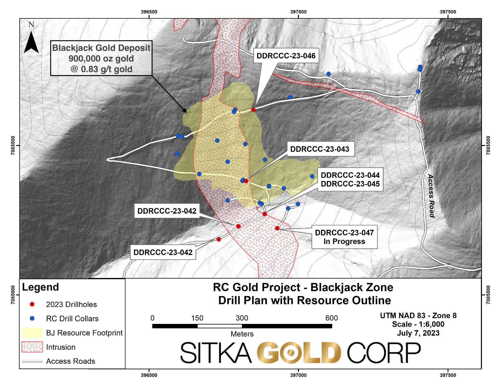
Sitka Gold (CSE:SIG), has shared a progress update on the diamond drilling program in its RC Gold Project located in the coveted Tombstone Gold Belt in Yukon, roughly 100 kilometres east of Dawson City. This ongoing project, with a planned drilling of up to 10,000 metres, is primarily focused on step out drilling to expand the original mineral resource estimate of 1,340,000 ounces of gold announced this year. This estimate comprises two surface-near gold deposits, namely the Blackjack and Eiger deposits, which remain open in all directions.
Cor Coe, CEO and Director of Sitka Gold, commented in a press release: “The first drill holes completed during the summer drilling campaign at RC Gold continue to highlight the expansion potential at our Blackjack gold deposit with additional visible gold occurrences observed in every hole logged to date. Part of this drilling included the deepening of Hole 043 where the entire 422 m hole had returned 0.74 g/t gold from surface, including 112 m of 1.24 g/t gold and 14 m of 3.28 g/t gold (see news release dated June 21, 2023). This hole was extended with an additional 104.6 m of mineralization observed to a total depth of 526.4 m. The mineralization with visible gold observed in these drill holes has the potential to add significant tonnage to the known mineralization at Blackjack and we look forward to receiving the analytical results of these holes as we continue our drill program at RC Gold.”
The main attention of the summer drilling program has been the Blackjack gold deposit, which boasts an inferred, pit-constrained 900,000 ounces of gold at a grade of 0.83 g/t. The ongoing step-out drilling has so far resulted in the completion of four drill holes, DDRCCC-23-043 to -046, with drilling in progress for DDRCCC-23-047 (refer to Figure 1). Every drill hole has managed to extend the known mineralization of the deposit, and visible gold has been noted in all logged holes to date (Holes 043, 044, and 045; refer to Figure 2). Analytical results for all drilled holes this summer are still pending.
The 2023 summer drilling season commenced with the continuation and completion of drill hole DDRCCC-23-043, ending in 111.7 m of 1.24 g/t Au starting from 315 m (see news release on June 21, 2023). Since then, three additional drill holes, DDRCCC-23-044 to 046, have been successfully completed, totalling 1353.3 m of drilling for this summer campaign.
Notably, DDRCCC-23-043 continued in megacrystic quartz monzonite (MQZMN), hosting quartz sulfide veins until it encountered a 6 m lamprophyre dyke, a known marker unit in the Blackjack Deposit. The hole then intersected moderately altered metasediments intruded by meter-scale MQZMN dyke, with both units cross-cut by quartz sulfide veins.
Both DDRCCC-23-044 and DDRCCC-23-045 were drilled from the same location with the aim to extend the current resource to the south and at depth (refer to Figure 1). They intersected moderately to strongly altered metasediments intersected by meter-scale MQZMN dyke throughout their length. Quartz vein density increased downhole in both holes, with visible gold also encountered. These holes are particularly noteworthy as they revealed the strongest alteration and quartz sulfide development seen in the metasediment unit in drilling on the RC Project to date, indicating potential significant gold mineralization (refer to Figure 3).
Hole DDRCCC-23-046 aimed to extend the margin of the current resource to the northeast. However, logging for this hole is not yet complete. The ongoing hole 47 was targeted to expand the southern margin of the current resource. The analytical results for all drilled holes in the ongoing summer drilling campaign remain pending.
The above references an opinion and is for information purposes only. It is not intended to be investment advice. Seek a licensed professional for investment advice. The author is not an insider or shareholder of any of the companies mentioned above.
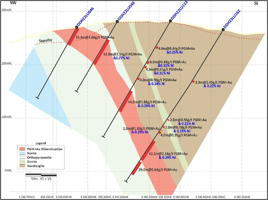
Bravo Mining (TSXV:BRVO) has announced assay results from a group of twenty-one diamond drill holes, which includes initial eight from Phase 2 Program aimed at identifying potential extension of the mineralization. The depth of this mineralization has been recorded approximately twice as deep, at 300m below the surface, than was discovered in the company’s Phase 1 Program.
Luis Azevedo, Chairman and CEO of Bravo Mining, commented in a press release: “The Phase 2 drill program is progressing as planned with initial results indicating PGM+Au+Ni mineralization is present as expected from ~150m to ~300m below surface (see Figures 3 and 4) with comparable thicknesses and grades to those intercepted at shallower depths tested during our Phase 1 Program. Drill hole DDH23LU184 has intercepted additional evidence of magmatic nickel sulphide mineralization in the Southwest Sector, further supporting the potential for nickel sulphides at depth at Luanga. We continue to be encouraged with such results, particularly as we await the final data interpretation of the recently completed HeliTEM survey, where preliminarily data interpretation suggests promising anomalies are present.”
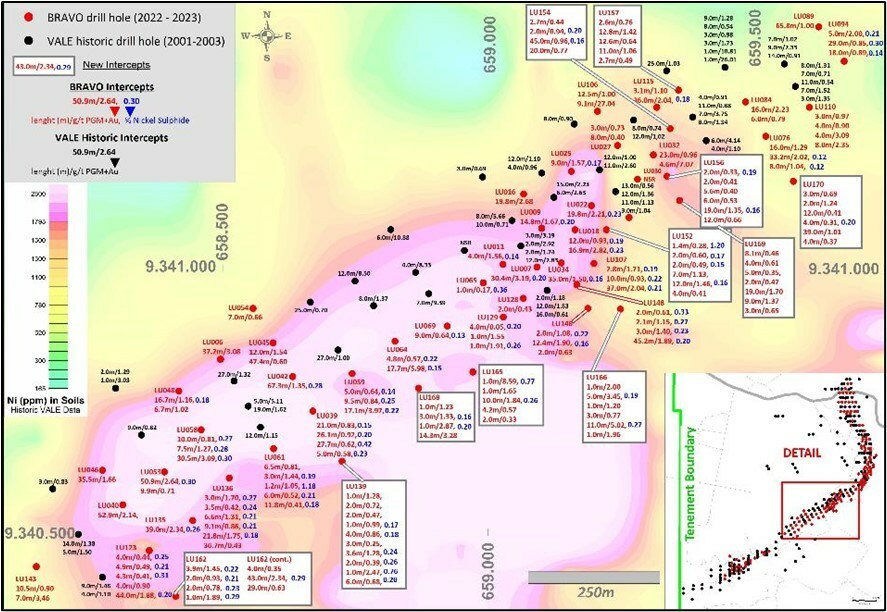
The newly released assay results include those from five drill holes in the Southwest Sector, eleven from the Central Sector, and five from the North Sector of Luanga Project, owned solely by Bravo Mining. These findings corroborate that the mineralization maintains its depth, similar thickness, and grades, as compared to both the company’s Phase 1 drill program and historic drilling in the neighboring sections.
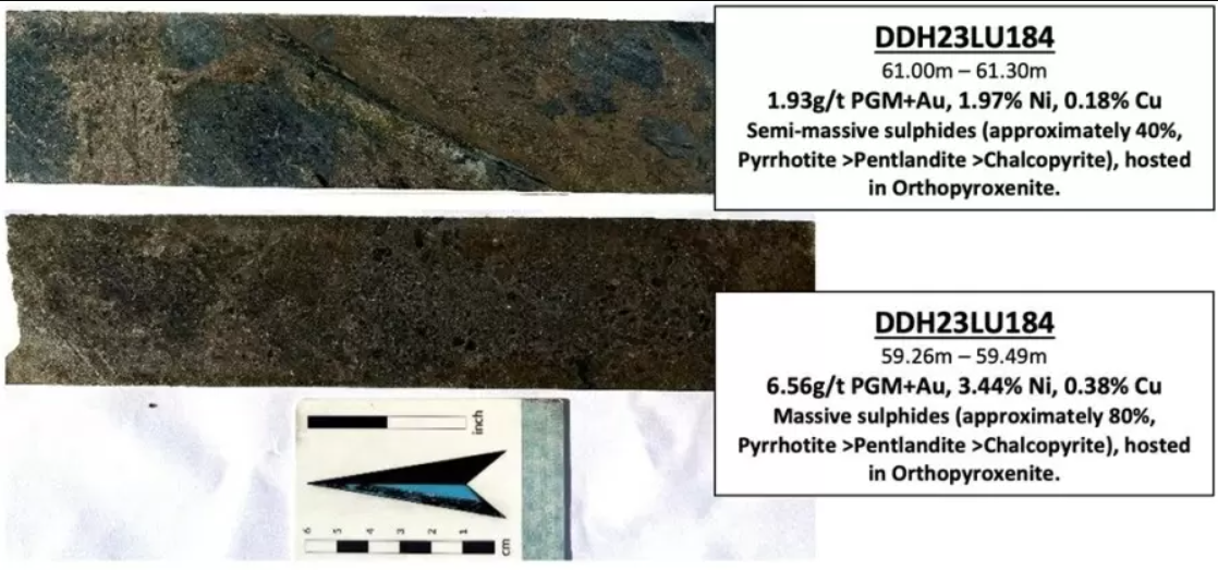
In the Southwest Sector, a new zone of magmatic nickel sulphide mineralization has been identified, with a 3.2m stretch of massive and semi-massive sulphides intercepted in the drill hole labeled DDH23LU184. The assay findings are consistent with the historical outcomes for platinum group metals (PGMs) when juxtaposed with the historic drilling in the nearby sections.
As of now, Bravo Mining has successfully completed a total of 197 drill holes, with 62 carried out in 2023, totalling to a length of 37,645 meters. This includes all eight twin holes and metallurgical holes planned by the company. A total of 169 Bravo drill holes’ results have been declared so far. There are 20 pending results from completed drill holes (excluding metallurgical ones), as per the company’s announcement.
Highlights from the results are as follows:
- DDH23LU184 returned further evidence of massive sulphide nickel in the Southwest Sector (Figure 1).
- First results from deeper drilling (Phase 2 Program) in the Central Sector have successfully identified mineralization to depths of up to ~300m below surface (Figures 3 and 4) with similar thicknesses and grades (PGM+Au and Ni Sulphide) as those in shallower Bravo drilling on the same sections.
- HeliTEM (airborne electromagnetics) was completed over the entire (7.810ha) Luanga project. Preliminary data shows that promising anomalies are present. Final data (expected soon) will enable full interpretation.
|
HOLE-ID |
From (m) |
To (m) |
Thickness |
Pd (g/t) |
Pt (g/t) |
Rh (g/t) |
Au |
PGM + |
Ni* (%) |
TYPE |
Sector |
|
DDH23LU152 |
94.8 |
96.2 |
1.4 |
0.22 |
0.04 |
0.00 |
0.02 |
0.28 |
1.20 |
FR |
Central |
|
Including |
95.5 |
96.2 |
0.7 |
0.30 |
0.06 |
0.00 |
0.02 |
0.39 |
1.92 |
FR |
|
|
And |
140.0 |
152.0 |
12.0 |
0.81 |
0.54 |
0.07 |
0.05 |
1.46 |
0.15 |
FR |
|
|
DDH23LU154 |
45.9 |
90.9 |
45.0 |
0.50 |
0.41 |
0.03 |
0.02 |
0.96 |
0.16 |
FR |
Central |
|
DDH23LU155 |
256.9 |
263.6 |
6.7 |
1.06 |
0.28 |
0.02 |
0.01 |
1.37 |
0.26 |
FR |
North |
|
Including |
258.7 |
259.5 |
0.9 |
3.28 |
0.46 |
0.01 |
0.01 |
3.76 |
1.15 |
FR |
|
|
DDH23LU156 |
119.0 |
138.0 |
19.0 |
0.77 |
0.49 |
0.07 |
0.02 |
1.35 |
0.16 |
FR |
Central |
|
DDH23LU157 |
5.6 |
18.4 |
12.8 |
0.79 |
0.38 |
0.03 |
0.21 |
1.42 |
NA |
Ox |
Central |
|
DDH23LU158 |
165.2 |
174.2 |
9.0 |
1.76 |
1.68 |
0.03 |
0.03 |
3.49 |
0.08 |
FR |
North |
|
DDH23LU162 |
246.8 |
289.8 |
43.0 |
1.70 |
0.52 |
0.08 |
0.05 |
2.34 |
0.29 |
FR |
Southwest |
|
DDH23LU165 |
196.3 |
206.3 |
10.0 |
1.17 |
0.44 |
0.02 |
0.22 |
1.84 |
0.26 |
FR |
Central |
|
DDH23LU166 |
271.4 |
282.4 |
11.0 |
2.92 |
1.47 |
0.22 |
0.42 |
5.02 |
0.27 |
FR |
Central |
|
DDH23LU167 |
209.7 |
251.7 |
42.0 |
0.77 |
0.24 |
0.04 |
0.01 |
1.05 |
0.16 |
FR |
Central |
|
DDH23LU168 |
260.7 |
275.0 |
14.3 |
2.12 |
0.96 |
0.15 |
0.05 |
3.28 |
0.13 |
FR |
Central |
|
DDH23LU169 |
162.7 |
181.7 |
19.0 |
1.07 |
0.54 |
0.06 |
0.03 |
1.70 |
0.13 |
FR |
Central |
|
DDH23LU170 |
249.0 |
288.0 |
39.0 |
0.60 |
0.34 |
0.05 |
0.02 |
1.01 |
0.10 |
FR |
Central |
|
DDH23LU184 |
59.1 |
62.3 |
3.2 |
1.54 |
0.55 |
0.59 |
0.19 |
2.86 |
1.81 |
FR |
Southwest |
|
Notes: |
All ‘From’, ‘To’ depths, and ‘Thicknesses’ are downhole. ‘NA’ Not applicable for Oxide material. |
|
Given the orientation of the hole and the mineralization, the intercepts are estimated to 110% to 120% of true thickness. |
|
|
Type: Ox = Oxide. LS = Low Sulphur. FR = Fresh Rock. Recovery methods and results will differ based on the type of mineralization. |
|
|
* Bravo’s nickel grades are sulphide nickel, and do not include non-recoverable silicate nickel, unlike historical total nickel assays. |
Complete Table of Recent Intercepts.
|
HOLE-ID |
From |
To |
Thickness |
Pd |
Pt |
Rh |
Au |
PGM + Au |
Ni* (%) |
Cu (%) |
TYPE |
|
DDH23LU139 |
123.9 |
124.9 |
1.0 |
0.88 |
0.29 |
0.00 |
0.11 |
1.28 |
0.10 |
FR |
|
|
And |
168.9 |
170.9 |
2.0 |
0.46 |
0.16 |
0.00 |
0.09 |
0.72 |
0.14 |
FR |
|
|
And |
185.3 |
187.3 |
2.0 |
0.27 |
0.15 |
0.00 |
0.04 |
0.47 |
0.10 |
FR |
|
|
And |
193.3 |
194.3 |
1.0 |
0.58 |
0.24 |
0.00 |
0.17 |
0.99 |
0.17 |
FR |
|
|
And |
216.8 |
220.8 |
4.0 |
0.57 |
0.21 |
0.00 |
0.08 |
0.86 |
0.18 |
FR |
|
|
And |
236.8 |
239.8 |
3.0 |
0.21 |
0.08 |
0.00 |
0.06 |
0.35 |
0.09 |
FR |
|
|
And |
253.9 |
257.5 |
3.6 |
0.84 |
0.28 |
0.03 |
0.12 |
1.28 |
0.24 |
FR |
|
|
And |
288.0 |
290.0 |
2.0 |
0.23 |
0.08 |
0.08 |
0.00 |
0.39 |
0.26 |
FR |
|
|
And |
301.3 |
302.3 |
1.0 |
1.90 |
0.40 |
0.15 |
0.01 |
2.47 |
0.76 |
FR |
|
|
And |
319.0 |
325.0 |
6.0 |
0.44 |
0.18 |
0.05 |
0.01 |
0.68 |
0.20 |
FR |
|
|
DDH23LU150 |
0.0 |
2.0 |
2.0 |
0.23 |
0.09 |
0.00 |
0.03 |
0.34 |
NA |
Ox |
|
|
And |
32.0 |
38.0 |
6.0 |
0.25 |
0.10 |
0.01 |
0.01 |
0.38 |
0.31 |
FR |
|
|
And |
44.0 |
46.0 |
2.0 |
0.33 |
0.13 |
0.00 |
0.02 |
0.48 |
0.12 |
FR |
|
|
And |
63.9 |
68.9 |
5.0 |
0.23 |
0.09 |
0.01 |
0.02 |
0.35 |
0.12 |
FR |
|
|
And |
79.9 |
82.0 |
2.1 |
0.38 |
0.18 |
0.01 |
0.01 |
0.58 |
0.07 |
FR |
|
|
And |
84.0 |
87.0 |
3.0 |
0.49 |
0.28 |
0.01 |
0.01 |
0.79 |
0.08 |
FR |
|
|
Including |
84.0 |
85.0 |
1.0 |
0.75 |
0.37 |
0.00 |
0.02 |
1.14 |
0.08 |
FR |
|
|
And |
93.0 |
98.1 |
5.1 |
0.39 |
0.27 |
0.03 |
0.01 |
0.71 |
0.03 |
FR |
|
|
Including |
94.0 |
95.0 |
1.0 |
1.34 |
0.63 |
0.10 |
0.04 |
2.10 |
0.12 |
FR |
|
|
DDH23LU151 |
0.0 |
5.2 |
5.2 |
0.23 |
0.12 |
0.00 |
0.02 |
0.38 |
NA |
Ox |
|
|
And |
20.7 |
22.7 |
2.0 |
0.58 |
0.20 |
0.00 |
0.02 |
0.81 |
0.30 |
FR |
|
|
And |
58.6 |
60.6 |
2.0 |
6.52 |
3.45 |
0.48 |
0.09 |
10.54 |
0.06 |
FR |
|
|
Including |
58.6 |
59.6 |
1.0 |
8.62 |
4.59 |
0.57 |
0.14 |
13.93 |
0.06 |
FR |
|
|
And |
64.6 |
66.6 |
2.0 |
0.40 |
0.20 |
0.01 |
0.00 |
0.61 |
0.06 |
FR |
|
|
DDH23LU152 |
94.8 |
96.2 |
1.4 |
0.22 |
0.04 |
0.00 |
0.02 |
0.28 |
1.20 |
FR |
|
|
Including |
95.5 |
96.2 |
0.7 |
0.30 |
0.06 |
0.00 |
0.02 |
0.39 |
1.92 |
FR |
|
|
And |
104.2 |
106.2 |
2.0 |
0.36 |
0.22 |
0.00 |
0.02 |
0.60 |
0.17 |
FR |
|
|
And |
114.2 |
116.2 |
2.0 |
0.28 |
0.16 |
0.00 |
0.05 |
0.49 |
0.15 |
FR |
|
|
And |
118.2 |
125.2 |
7.0 |
0.24 |
0.15 |
0.02 |
0.03 |
0.44 |
0.12 |
FR |
|
|
And |
131.0 |
138.0 |
7.0 |
0.56 |
0.34 |
0.03 |
0.21 |
1.13 |
0.16 |
FR |
|
|
And |
140.0 |
152.0 |
12.0 |
0.81 |
0.54 |
0.07 |
0.05 |
1.46 |
0.15 |
FR |
|
|
Including |
145.0 |
146.0 |
1.0 |
2.37 |
1.62 |
0.35 |
0.09 |
4.43 |
0.29 |
FR |
|
|
And |
157.0 |
161.0 |
4.0 |
0.26 |
0.13 |
0.01 |
0.01 |
0.41 |
0.06 |
FR |
|
|
DDH23LU153 |
47.3 |
52.3 |
5.0 |
0.14 |
0.36 |
0.00 |
0.01 |
0.52 |
0.22 |
FR |
|
|
And |
100.3 |
107.3 |
7.0 |
0.19 |
0.14 |
0.02 |
0.01 |
0.36 |
0.03 |
FR |
|
|
DDH23LU154 |
0.0 |
2.7 |
2.7 |
0.26 |
0.14 |
0.01 |
0.04 |
0.44 |
NA |
Ox |
|
|
And |
21.2 |
23.2 |
2.0 |
0.28 |
0.59 |
0.00 |
0.08 |
0.94 |
0.20 |
FR |
|
|
And |
45.9 |
90.9 |
45.0 |
0.50 |
0.41 |
0.03 |
0.02 |
0.96 |
0.16 |
FR |
|
|
Including |
65.9 |
76.9 |
11.0 |
0.75 |
0.52 |
0.06 |
0.01 |
1.34 |
0.27 |
FR |
|
|
And |
95.9 |
115.9 |
20.0 |
0.29 |
0.42 |
0.05 |
0.01 |
0.77 |
0.02 |
FR |
|
|
Including |
106.9 |
107.9 |
1.0 |
1.66 |
4.53 |
0.61 |
0.03 |
6.84 |
0.02 |
FR |
|
|
DDH23LU155 |
0.0 |
7.0 |
7.0 |
0.15 |
0.15 |
0.01 |
0.00 |
0.32 |
NA |
Ox |
|
|
And |
155.5 |
160.5 |
5.0 |
0.19 |
0.16 |
0.02 |
0.00 |
0.38 |
0.03 |
FR |
|
|
And |
172.5 |
177.5 |
5.0 |
0.16 |
0.12 |
0.02 |
0.00 |
0.30 |
0.14 |
FR |
|
|
And |
182.5 |
183.5 |
1.0 |
0.88 |
0.17 |
0.04 |
0.04 |
1.12 |
0.08 |
FR |
|
|
And |
193.5 |
196.5 |
3.0 |
0.33 |
0.13 |
0.02 |
0.02 |
0.49 |
0.16 |
FR |
|
|
And |
209.0 |
209.8 |
0.9 |
0.68 |
0.09 |
0.09 |
0.02 |
0.88 |
0.67 |
FR |
|
|
And |
217.8 |
228.8 |
11.0 |
0.39 |
0.11 |
0.02 |
0.01 |
0.54 |
0.10 |
FR |
|
|
And |
236.8 |
240.8 |
4.0 |
0.35 |
0.09 |
0.01 |
0.00 |
0.46 |
0.12 |
FR |
|
|
And |
244.8 |
248.8 |
4.0 |
0.71 |
0.22 |
0.06 |
0.00 |
0.99 |
0.10 |
FR |
|
|
And |
251.8 |
254.8 |
3.0 |
0.22 |
0.22 |
0.01 |
0.00 |
0.46 |
0.06 |
FR |
|
|
And |
256.9 |
263.6 |
6.7 |
1.06 |
0.28 |
0.02 |
0.01 |
1.37 |
0.26 |
FR |
|
|
Including |
258.7 |
259.5 |
0.9 |
3.28 |
0.46 |
0.01 |
0.01 |
3.76 |
1.15 |
FR |
|
|
And |
267.6 |
270.4 |
2.7 |
0.29 |
0.15 |
0.01 |
0.09 |
0.54 |
0.05 |
FR |
|
|
DDH23LU156 |
40.2 |
42.2 |
2.0 |
0.22 |
0.09 |
0.01 |
0.01 |
0.33 |
0.19 |
Ox/LS |
|
|
And |
75.0 |
77.0 |
2.0 |
0.19 |
0.11 |
0.01 |
0.10 |
0.41 |
0.05 |
FR |
|
|
And |
92.5 |
98.0 |
5.6 |
0.22 |
0.13 |
0.00 |
0.05 |
0.40 |
0.06 |
FR |
|
|
And |
113.0 |
119.0 |
6.0 |
0.31 |
0.19 |
0.01 |
0.01 |
0.53 |
0.13 |
FR |
|
|
And |
119.0 |
138.0 |
19.0 |
0.77 |
0.49 |
0.07 |
0.02 |
1.35 |
0.16 |
FR |
|
|
And |
142.0 |
154.0 |
12.0 |
0.41 |
0.22 |
0.01 |
0.02 |
0.66 |
0.04 |
FR |
|
|
Including |
143.0 |
145.0 |
2.0 |
0.64 |
0.29 |
0.02 |
0.11 |
1.05 |
0.09 |
FR |
|
|
DDH23LU157 |
0.0 |
2.6 |
2.6 |
0.43 |
0.26 |
0.01 |
0.06 |
0.76 |
NA |
Ox |
|
|
And |
5.6 |
18.4 |
12.8 |
0.79 |
0.38 |
0.03 |
0.21 |
1.42 |
NA |
Ox |
|
|
And |
27.4 |
40.0 |
12.6 |
0.37 |
0.24 |
0.01 |
0.02 |
0.64 |
0.04 |
Ox/LS |
|
|
And |
42.0 |
53.0 |
11.0 |
0.66 |
0.34 |
0.04 |
0.01 |
1.06 |
0.04 |
FR |
|
|
And |
64.0 |
66.7 |
2.7 |
0.10 |
0.32 |
0.07 |
0.00 |
0.49 |
0.01 |
FR |
|
|
DDH23LU158 |
97.2 |
101.2 |
4.0 |
0.44 |
0.39 |
0.00 |
0.01 |
0.84 |
0.05 |
FR |
|
|
And |
110.2 |
113.2 |
3.0 |
1.54 |
1.35 |
0.11 |
0.01 |
3.01 |
0.11 |
FR |
|
|
And |
118.2 |
121.2 |
3.0 |
0.27 |
0.13 |
0.01 |
0.05 |
0.46 |
0.11 |
FR |
|
|
And |
165.2 |
174.2 |
9.0 |
1.76 |
1.68 |
0.03 |
0.03 |
3.49 |
0.08 |
FR |
|
|
Including |
167.2 |
169.2 |
2.0 |
4.42 |
5.23 |
0.03 |
0.06 |
9.75 |
0.18 |
FR |
|
|
And |
201.6 |
204.4 |
2.9 |
0.86 |
0.35 |
0.01 |
0.02 |
1.24 |
0.39 |
FR |
|
|
DDH23LU159 |
66.8 |
68.8 |
2.0 |
0.29 |
0.33 |
0.04 |
0.00 |
0.67 |
0.04 |
FR |
|
|
And |
106.5 |
115.2 |
8.7 |
0.08 |
0.07 |
0.01 |
0.14 |
0.31 |
0.10 |
FR |
|
|
And |
204.4 |
209.3 |
4.8 |
0.26 |
0.19 |
0.01 |
0.00 |
0.46 |
0.18 |
FR |
|
|
Including |
204.4 |
205.3 |
0.9 |
0.85 |
0.20 |
0.06 |
0.01 |
1.12 |
0.56 |
FR |
|
|
DDH23LU160 |
15.8 |
22.8 |
7.0 |
0.49 |
0.15 |
0.14 |
0.05 |
0.83 |
NA |
Ox |
|
|
Including |
15.8 |
17.8 |
2.0 |
0.92 |
0.26 |
0.26 |
0.08 |
1.53 |
NA |
Ox |
|
|
And |
60.3 |
65.4 |
5.1 |
0.76 |
0.33 |
0.01 |
0.09 |
1.18 |
0.05 |
FR |
|
|
DDH23LU161 |
0.0 |
3.5 |
3.5 |
0.25 |
0.34 |
0.03 |
0.03 |
0.64 |
NA |
Ox |
|
|
And |
33.5 |
34.4 |
0.9 |
0.79 |
0.64 |
0.11 |
0.01 |
1.55 |
NA |
Ox/LS |
|
|
And |
86.1 |
94.1 |
8.0 |
0.29 |
0.23 |
0.02 |
0.01 |
0.55 |
0.15 |
FR |
|
|
And |
103.1 |
112.1 |
9.0 |
0.65 |
0.69 |
0.12 |
0.01 |
1.46 |
0.09 |
FR |
|
|
And |
120.1 |
132.4 |
12.3 |
0.33 |
0.25 |
0.03 |
0.01 |
0.62 |
0.05 |
FR |
|
|
Including |
121.1 |
125.1 |
4.0 |
0.58 |
0.45 |
0.06 |
0.03 |
1.12 |
0.04 |
FR |
|
|
And |
137.0 |
138.0 |
1.1 |
1.15 |
3.00 |
0.07 |
0.02 |
4.24 |
0.54 |
FR |
|
|
DDH23LU162 |
111.1 |
115.0 |
3.9 |
0.84 |
0.36 |
0.05 |
0.21 |
1.45 |
0.22 |
FR |
|
|
And |
197.9 |
199.9 |
2.0 |
0.63 |
0.19 |
0.04 |
0.07 |
0.93 |
0.21 |
FR |
|
|
And |
213.9 |
215.9 |
2.0 |
0.47 |
0.14 |
0.08 |
0.10 |
0.78 |
0.23 |
FR |
|
|
And |
221.9 |
222.8 |
1.0 |
1.40 |
0.25 |
0.08 |
0.17 |
1.89 |
0.29 |
FR |
|
|
And |
225.8 |
229.8 |
4.0 |
0.24 |
0.07 |
0.01 |
0.03 |
0.35 |
0.11 |
FR |
|
|
And |
246.8 |
289.8 |
43.0 |
1.70 |
0.52 |
0.08 |
0.05 |
2.34 |
0.29 |
FR |
|
|
Including |
270.8 |
274.8 |
4.0 |
2.41 |
0.71 |
0.13 |
0.14 |
3.40 |
0.44 |
FR |
|
|
And |
293.8 |
322.8 |
29.0 |
0.36 |
0.26 |
0.00 |
0.01 |
0.63 |
0.02 |
FR |
|
|
DDH23LU165 |
99.4 |
100.4 |
1.0 |
5.87 |
2.50 |
0.08 |
0.14 |
8.59 |
0.77 |
FR |
|
|
And |
183.4 |
184.4 |
1.0 |
1.03 |
0.58 |
0.01 |
0.02 |
1.65 |
0.09 |
FR |
|
|
And |
196.3 |
206.3 |
10.0 |
1.17 |
0.44 |
0.02 |
0.22 |
1.84 |
0.26 |
FR |
|
|
Including |
200.4 |
204.6 |
4.2 |
1.77 |
0.70 |
0.02 |
0.39 |
2.87 |
0.29 |
FR |
|
|
And |
208.5 |
212.7 |
4.2 |
0.32 |
0.16 |
0.00 |
0.09 |
0.57 |
0.06 |
FR |
|
|
And |
315.6 |
317.6 |
2.0 |
0.20 |
0.13 |
0.00 |
0.00 |
0.33 |
0.03 |
FR |
|
|
DDH23LU166 |
92.0 |
93.0 |
1.0 |
1.12 |
0.45 |
0.00 |
0.43 |
2.00 |
0.13 |
FR |
|
|
And |
160.5 |
165.5 |
5.0 |
2.53 |
0.70 |
0.14 |
0.09 |
3.45 |
0.19 |
FR |
|
|
Including |
160.5 |
161.5 |
1.0 |
7.75 |
1.90 |
0.67 |
0.14 |
10.46 |
0.14 |
FR |
|
|
And |
172.5 |
173.5 |
1.0 |
0.86 |
0.31 |
0.00 |
0.03 |
1.20 |
0.13 |
FR |
|
|
And |
267.4 |
270.4 |
3.0 |
0.41 |
0.24 |
0.01 |
0.10 |
0.77 |
0.09 |
FR |
|
|
And |
271.4 |
282.4 |
11.0 |
2.92 |
1.47 |
0.22 |
0.42 |
5.02 |
0.27 |
FR |
|
|
Including |
277.4 |
281.4 |
4.0 |
4.31 |
2.17 |
0.31 |
0.42 |
7.21 |
0.36 |
FR |
|
|
And |
285.4 |
286.4 |
1.0 |
1.18 |
0.67 |
0.07 |
0.03 |
1.96 |
0.05 |
FR |
|
|
DDH23LU167 |
41.6 |
44.8 |
3.2 |
0.20 |
0.07 |
0.00 |
0.05 |
0.32 |
0.06 |
FR |
|
|
And |
209.7 |
251.7 |
42.0 |
0.77 |
0.24 |
0.04 |
0.01 |
1.05 |
0.16 |
FR |
|
|
Including |
249.7 |
251.7 |
2.0 |
2.27 |
0.64 |
0.13 |
0.02 |
3.06 |
0.17 |
FR |
|
|
And |
265.7 |
277.7 |
12.0 |
0.12 |
0.21 |
0.00 |
0.00 |
0.33 |
0.01 |
FR |
|
|
DDH23LU168 |
77.6 |
78.6 |
1.0 |
0.61 |
0.50 |
0.00 |
0.12 |
1.23 |
0.08 |
FR |
|
|
And |
155.3 |
158.3 |
3.0 |
0.78 |
0.39 |
0.00 |
0.15 |
1.33 |
0.16 |
FR |
|
|
And |
253.7 |
254.7 |
1.0 |
2.44 |
0.19 |
0.13 |
0.12 |
2.87 |
0.20 |
FR |
|
|
And |
260.7 |
275.0 |
14.3 |
2.12 |
0.96 |
0.15 |
0.05 |
3.28 |
0.13 |
FR |
|
|
Including |
270.9 |
274.0 |
3.1 |
4.89 |
2.15 |
0.33 |
0.05 |
7.43 |
0.17 |
FR |
|
|
DDH23LU169 |
26.0 |
34.1 |
8.1 |
0.28 |
0.12 |
0.00 |
0.06 |
0.46 |
NA |
Ox/LS |
|
|
And |
38.0 |
42.0 |
4.0 |
0.38 |
0.15 |
0.02 |
0.07 |
0.61 |
0.13 |
FR |
|
|
And |
145.7 |
150.7 |
5.0 |
0.21 |
0.12 |
0.00 |
0.01 |
0.35 |
0.17 |
FR |
|
|
And |
158.7 |
160.7 |
2.0 |
0.26 |
0.17 |
0.01 |
0.02 |
0.47 |
0.05 |
FR |
|
|
And |
162.7 |
181.7 |
19.0 |
1.07 |
0.54 |
0.06 |
0.03 |
1.70 |
0.13 |
FR |
|
|
And |
189.7 |
198.7 |
9.0 |
0.92 |
0.37 |
0.07 |
0.02 |
1.37 |
0.06 |
FR |
|
|
And |
224.7 |
227.7 |
3.0 |
0.19 |
0.46 |
0.00 |
0.01 |
0.65 |
0.01 |
FR |
|
|
DDH23LU170 |
116.4 |
119.4 |
3.0 |
0.43 |
0.17 |
0.00 |
0.09 |
0.69 |
0.02 |
FR |
|
|
And |
190.6 |
192.6 |
2.0 |
0.69 |
0.36 |
0.04 |
0.15 |
1.24 |
0.13 |
FR |
|
|
And |
220.0 |
232.0 |
12.0 |
0.20 |
0.10 |
0.01 |
0.10 |
0.41 |
0.09 |
FR |
|
|
And |
240.0 |
244.0 |
4.0 |
0.20 |
0.09 |
0.00 |
0.01 |
0.31 |
0.20 |
FR |
|
|
And |
249.0 |
288.0 |
39.0 |
0.60 |
0.34 |
0.05 |
0.02 |
1.01 |
0.10 |
FR |
|
|
Including |
254.0 |
255.0 |
1.0 |
3.25 |
1.84 |
0.31 |
0.08 |
5.48 |
0.20 |
FR |
|
|
And |
290.0 |
294.0 |
4.0 |
0.16 |
0.14 |
0.02 |
0.04 |
0.37 |
0.03 |
FR |
|
|
DDH23LU184 |
59.1 |
62.3 |
3.2 |
1.54 |
0.55 |
0.59 |
0.19 |
2.86 |
1.81 |
0.18 |
FR |
|
Notes: |
All ‘From’, ‘To’ depths, and ‘Thicknesses’ are downhole. ‘NA’ Not applicable for Oxide material. |
|
Given the orientation of the hole and the mineralization, the intercepts are estimated to 110% to 120% of true thickness. |
|
|
Type: Ox = Oxide. LS = Low Sulphur. FR = Fresh Rock. Recovery methods and results will differ based on the type of mineralization. |
|
|
* Bravo’s nickel grades are sulphide nickel, and do not include non-recoverable silicate nickel, unlike historical total nickel assays |
The above references an opinion and is for information purposes only. It is not intended to be investment advice. Seek a licensed professional for investment advice. The author is not an insider or shareholder of any of the companies mentioned above.
First Mining Gold (TSX:FF) has reported results from its 2023 drilling program, aimed at progressing its Saddle drilling target, part of the Birch-Uchi Greenstone Belt Project situated in northwestern Ontario, Canada. The Saddle target is around 12 kilometres southwest of the company’s Springpole Gold Project.
Dan Wilton, CEO of First Mining Gold, commented in a press release: “Our regional exploration efforts are demonstrating the ability to identify mineralization settings that support new discoveries and potential satellite opportunities in this emerging gold district. In only our second drill target tested, we are seeing the strength of gold endowment hosted in the Birch-Uchi Greenstone Belt where First Mining has focused exploration surrounding its flagship Springpole Gold Project.”
During the winter drilling operation at the Birch-Uchi Project, eleven drill holes totaling 2,760 meters were drilled at three targets: Saddle, Horseshoe, and Atlantis. The first drilling by First Mining Gold at Saddle incorporated five drill holes totaling 842 meters. These operations identified a substantial gold mineralization system, yielding grades of 0.92 g/t Au over 114.0 meters in hole SAT23-001, and 0.75 g/t Au over 57.7 meters in drill hole SAT23-002.
The Saddle target is nestled within the Birch-Uchi Greenstone Belt (“BUGB”), a significant host for granodiorite intrusive that is intensely deformed and mineralized in contact with sedimentary lithologies. Mineralization correlates with heightened silica and carbonate alteration, robust quartz veining, and sulphides. Dominantly, the sulphide mineralization consists of pyrite, with fine to coarse-grained disseminations averaging an abundance of 1-7%, and localized up to 15-20%. The 2023 drilling results show a mineralization envelope that is continuous on both sides of the shear zone.
The Saddle target is a lesser-known opportunity that has witnessed historical prospecting and geoscience programs such as induced polarization, airborne magnetic geophysics, and diamond drilling during the 1980s. Since then, exploration activities in this promising area have been scarce.
In 2021, First Mining concluded a concentrated field campaign following up on the Rice Lake, Green Camp, Exit Bay, and Trench Grid gold occurrences that align notably with the Saddle Target over a projected 1 km strike length. The potential to expand the mineralization system and prospect within a related structural setting has increased the regional prospectivity in promoting the area.
During 2022, the company carried out additional airborne geophysics surveys that facilitated improved targeting resolution for exploration drilling. This data was useful in designing step-out exploration plans for the Saddle target.
In the 2023 winter program, First Mining successfully completed 842 m of drilling in five exploration drill holes centred on the Saddle target. The operation was designed to confirm the newly created 3D exploration model, drawing on historical drilling and field-based data collection, and testing extensions along strike, at depth, and across an interpreted fault offset.
The winter drilling’s outcomes highlight robust intervals of consistent gold mineralization over significant widths. The program has been successful in confirming the continuation of the mineralization envelope along the shear structure, thus expanding the exploration growth potential around the Saddle target.
The company plans to continue its geological mapping and data collection efforts around the Saddle target in its 2023 summer field programs, with a particular focus on the quartz stockwork and chlorite alteration on the surface within areas of anomalous geophysical signatures.
First Mining Gold is also looking forward to disclosing the results from an additional six holes totalling 1,938 meters completed at the Horseshoe and Atlantis targets during the winter season once the company finalizes assay reviews.
Highlights from the results are as follows:
- Initial drilling campaign on the Saddle target since property acquisition returned consistent gold mineralization over meaningful widths that remains open for expansion
- Historical grab rock samples validated by field program follow-up
- Employed geoscience systems approach to characterize the target geology, supporting additional exploration opportunities in close proximity to the immediate drill area
- BUGB Project is proving to be prospective with a second drilled target delivering meaningful opportunity
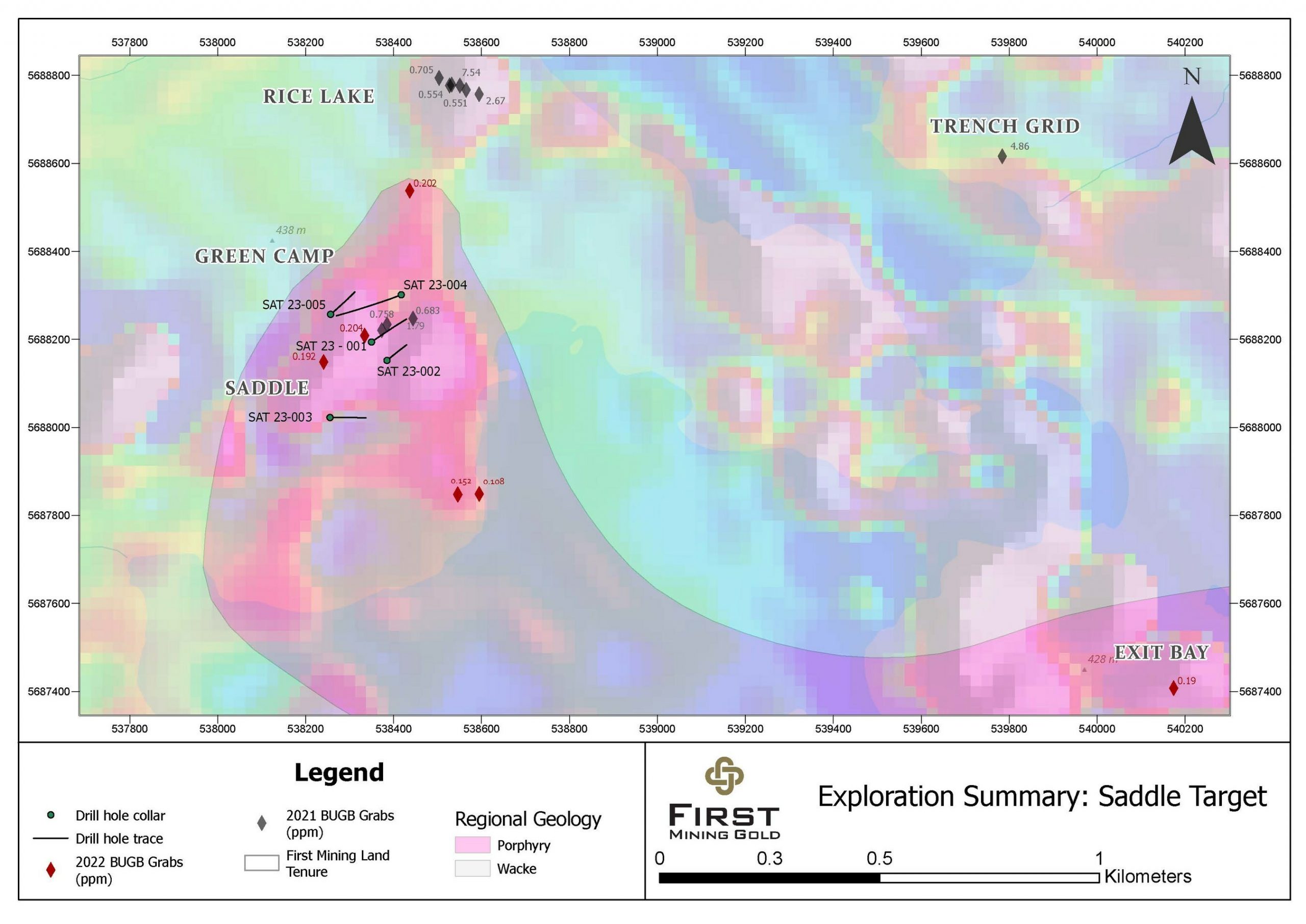
Table 1: Selected Significant Drill Intercept Results at Saddle Target
|
Hole ID |
From (m) |
To (m) |
Length (m) |
Au (g/t) |
Target |
|
SAT23-001 |
4.00 |
118.0 |
114.0 |
0.92 |
Saddle |
|
SAT23-002 |
51.00 |
108.70 |
57.70 |
0.75 |
Saddle |
|
SAT23-004 |
7.50 |
62.00 |
54.5 |
0.58 |
Saddle |
|
*Reported intervals are drilled core lengths, true widths are not yet established; assay values are uncut |
Table 2: Significant Drill Intercept Results at the Saddle Target
|
Hole ID |
From (m) |
To (m) |
Length (m) |
Au (g/t) |
Target |
|
SAT23-001 |
4.00 |
118.0 |
114.0 |
0.92 |
Saddle |
|
including |
7.00 |
16.00 |
9.00 |
1.24 |
|
|
including |
23.65 |
24.88 |
1.23 |
4.41 |
|
|
including |
33.00 |
46.00 |
13.00 |
1.36 |
|
|
including |
107.00 |
116.56 |
9.56 |
1.23 |
|
|
and |
123.00 |
133.95 |
10.95 |
0.54 |
|
|
SAT23-002 |
51.00 |
108.70 |
57.70 |
0.75 |
Saddle |
|
including |
93.00 |
104.50 |
11.50 |
1.11 |
|
|
and |
119.00 |
121.00 |
2.00 |
0.55 |
|
|
SAT23-003 |
132.00 |
132.70 |
0.70 |
1.12 |
Saddle |
|
SAT23-004 |
7.50 |
62.00 |
54.50 |
0.58 |
Saddle |
|
including |
49.00 |
50.00 |
1.00 |
5.36 |
|
|
including |
61.00 |
62.00 |
1.00 |
3.23 |
|
|
and |
139.00 |
143.00 |
4.00 |
0.47 |
|
|
SAT23-005 |
27.00 |
32.65 |
5.65 |
0.30 |
Saddle |
|
and |
50.00 |
69.00 |
19.00 |
0.36 |
Table 3: Drill Hole Locations, Saddle Target
|
Hole ID |
Azimuth (°) |
Dip (°) |
Length (m) |
UTM E |
UTM N |
Target |
|
SAT23-001 |
55 |
-55 |
167 |
538350 |
5688194 |
Saddle |
|
SAT23-002 |
50 |
-70 |
156 |
538385 |
5688152 |
Saddle |
|
SAT23-003 |
90 |
-60 |
155 |
538255 |
5688023 |
Saddle |
|
SAT23-004 |
247 |
-45 |
203 |
538417 |
5688302 |
Saddle |
|
SAT23-005 |
50 |
-63 |
161 |
538257 |
5688257 |
Saddle |
The above references an opinion and is for information purposes only. It is not intended to be investment advice. Seek a licensed professional for investment advice. The author is not an insider or shareholder of any of the companies mentioned above.
VR Resources (TSXV:VRR) has announced significant developments at its Northway site in northern Ontario. The company completed drill hole NW23-003, reaching 627 m in depth. The drilling operation unveiled a substantial kimberlite breccia deposit spanning an area of about 700 m laterally and roughly 320 m vertically below a layer of sandstone.
The NW23-003 drill hole was initiated at a depth of around 240 m, revealing a xenolith-rich kimberlite breccia (XPK) layer that continued further down. This depth is consistent with the previous two drilling operations at the site.
The company has now completed drilling in three holes, resulting in approximately 500 m of kimberlite core samples. These are estimated to amount to about 1.3 metric tonnes of material. The company is planning compositional studies and microdiamond evaluations on these samples at the SRC laboratory in Saskatoon. The preparation and shipment of these samples are scheduled for the second week of July.
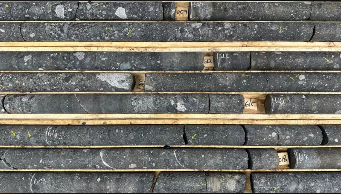
Notably, the NW23-003 hole, like its predecessor, is located in the heart of a magnetic anomaly, a region of strong magnetic field, hinting at a large concentration of minerals. It’s aligned steeply to the north at a -65o inclination.
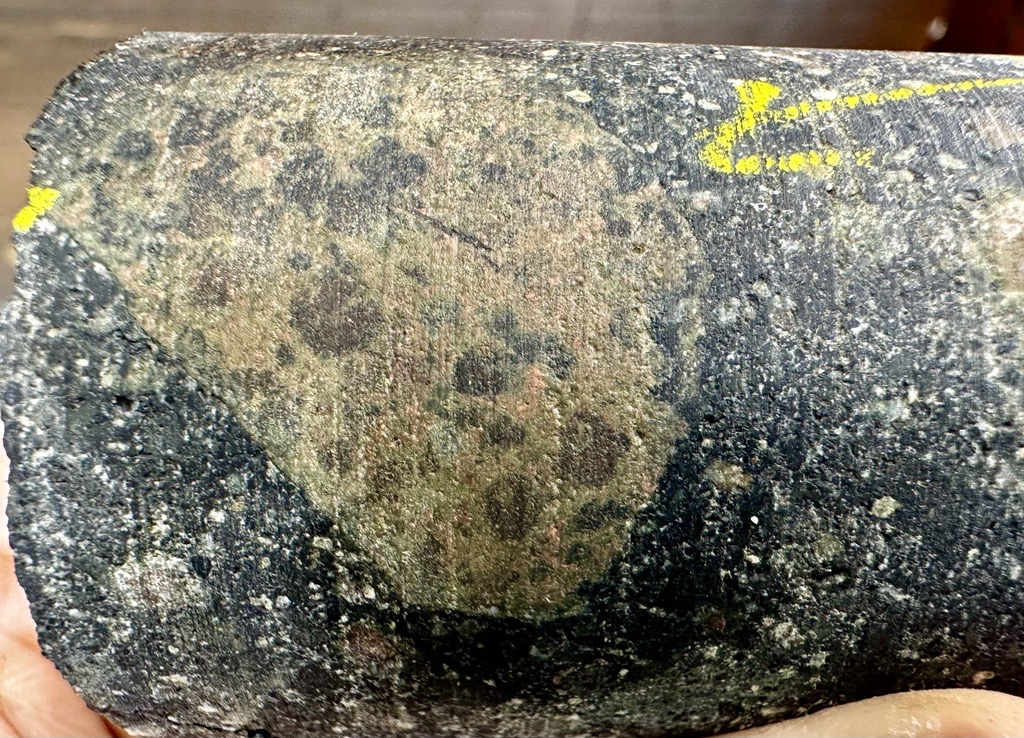
The company also unveiled changes to its corporate structure, announcing the adoption of a long-term incentive plan (LTIP) involving restricted share units (RSUs) and deferred share units (DSUs). This plan is designed to attract, retain and motivate highly qualified personnel, align their interests with the company’s shareholders, and foster long-term growth. The LTIP will come into effect on July 6, 2023.
However, the LTIP is yet to be ratified by the company’s shareholders and approved by the TSX Venture Exchange. The company will seek these approvals at a shareholders’ meeting scheduled for August 31, 2023. The maximum number of RSUs/DSUs that can be issued under the LTIP cannot exceed 11,396,636 common shares, which is 10% of the common shares of the company as of the effective date.
VR Resources CEO, Dr. Michael Gunning, commented in a press release: “Having now hit kimberlite breccia in 3 drill holes spanning some 700m across the magnetic anomaly at Northway, the sheer scale and energy of this kimberlitic event and breccia pipe complex is both obvious and exceptional.
There is kimberlite breccia to the bottom of hole 003, which is some 700 m laterally from the kimberlite crater facies seen at the top of hole 001, and we have yet to even see the northwestern part of the complex with the three holes completed to date. Similarly, we see no constraints for the depth extent of the breccia based on observations in drill core, including xenolith-rich XPK breccia at the bottom of hole 003, and based on the continuity in the 1,000 metres of vertical extent in our 3D magnetic inversion block model.
With that realization towards the sheer scale of the KPK breccia rocks at Northway, and the potential for a new Devonian-aged kimberlite field in the northern Superior craton, we are now scoping the acquisition of detailed magnetic data on the twenty-odd magnetic anomalies that we have staked around Northway, and proximal to the active Ontario Northern railroad.
We now have over a metric ton of drill core in three holes spanning some 700 metres laterally and 320 metres vertically within the breccia pipe complex at Northway. This amount of core will optimize a first-pass evaluation of the micro-diamond potential by caustic fusion, and provide for a robust compositional characterization of the breccia.
In order to appreciate the upside potential of Northway itself, and of the expanded strategy related to the field of similar targets staked by VR following the discovery in hole 001, I would again encourage our shareholders to remind themselves of the drill core photos and geological context for this discovery as outlined in the previous news releases dated February 22 and May 18, 2023, respectively, and as summarized on the Northway project page on the Company’s new website at www.vrr.ca.
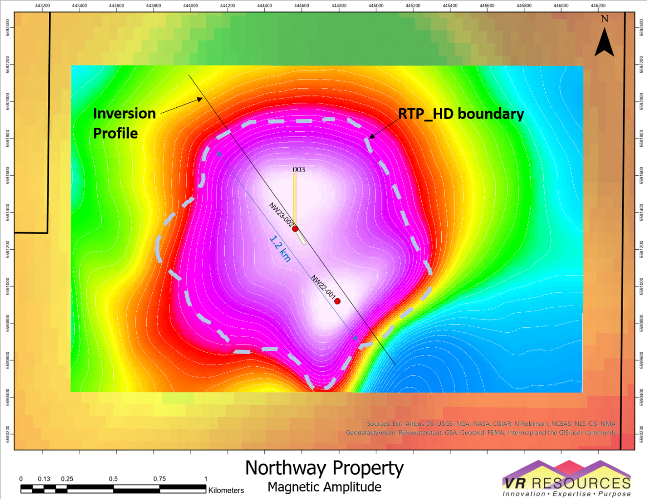
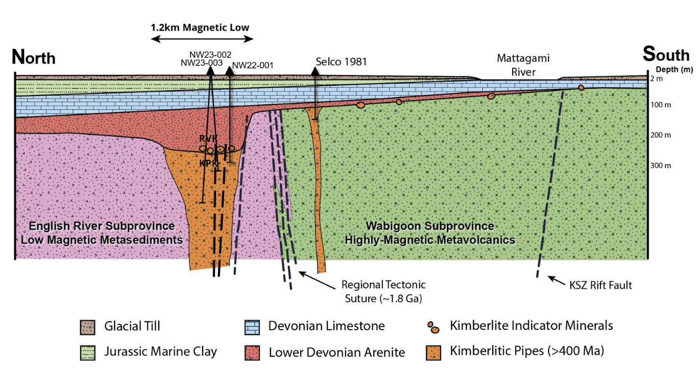
The above references an opinion and is for information purposes only. It is not intended to be investment advice. Seek a licensed professional for investment advice. The author is not an insider or shareholder of any of the companies mentioned above.
Brazil Potash’s Autazes project, located in the Amazonas region, has the potential to significantly alter the country’s potash landscape, and is progressing toward production every day. The project’s main focus is on potash, an essential mineral for the production of potassium-rich fertilizers. The region’s potash reserves are estimated to be vast, with the potential to produce 2.2 million tonnes annually once the project is fully operational.
The Autazes Potash project’s strategic location, with access to an abundant renewable energy source and proximity to major farming regions, makes it uniquely positioned for success. It could not only alleviate the country’s reliance on imported potash, but also contribute to the local and national economy via job creation and increased revenues.
The Consultation Process and Installation License
The installation license, a pivotal step towards the project’s materialization, has been a focus for the Brazil Potash management. This license is necessary to commence project construction. Its acquisition involves a multi-step consultation process with various stakeholders, including the local communities, environmental agencies, and governmental bodies.
Recently, the President of Brazil’s Federal court (TRF-1) ruled to reinstate Brazil Potash’s Preliminary (Social and Environmental) License, a crucial milestone in obtaining the Installation License. This indicates the government’s willingness to back projects that could contribute to the country’s self-sufficiency in critical sectors and stimulate economic growth.
Impact on Local Communities
One of the main benefits of the Autazes Potash Project is its far-reaching and positive impact on local communities. Brazil Potash is not just focused on mining potash; it is committed to transforming the lives of the residents in the communities where it operates.
Nourishing Communities
Food security is a significant issue in many parts of Brazil, and Brazil Potash is helping to combat this issue through various initiatives. The company has donated large quantities of food to the local communities surrounding the Autazes Potash Project during COVID 19. These donations help to alleviate immediate food security concerns, and they also foster goodwill and trust between the company and the communities in which it operates.
Fostering Sustainable Agriculture
In addition to addressing immediate food security needs, Brazil Potash is also invested in promoting sustainable agriculture within these communities. The company recently donated over 5,000 seedlings to the Amazonas state government, grown in their own nursery located in the Urucurituba village in the Autazes municipality. These seedlings, which include a variety of fruit, forest, ornamental, and medicinal plants, are intended to boost rural production, promote food security, and contribute to combating climate change by sequestering greenhouse gasses.
This initiative aligns with Brazil Potash’s commitment to sustainability and environmental stewardship. It also empowers local farmers by providing them with resources to enhance their livelihoods in a sustainable manner.
Infrastructure Development
Brazil Potash understands the importance of robust infrastructure in community development. That’s why the company has donated construction materials to local municipalities, contributing to the development of community infrastructure. These materials have facilitated the construction and repair of facilities, enhancing the overall quality of life for local residents.
Job Creation and Economic Stimulation
Perhaps the most profound impact of the Autazes Potash Project will be its contribution to local economies through job creation. Brazil Potash has committed to employing local residents in the project, thereby creating a significant number of job opportunities in a region where employment options might otherwise be limited.
In addition to direct employment, the project is also expected to stimulate other sectors of the local economy indirectly. For example, the influx of workers and economic activity surrounding the project could increase demand for local goods and services, benefiting a wide range of businesses and stimulating economic growth in the region.
Potential for a Better Future for Brazilian Agriculture
Brazil’s agriculture sector is expected to benefit from the Autazes Potash project. Potash, a major component of fertilizers, plays a critical role in enhancing soil fertility and crop yield. However, Brazil imports most of its potash requirements, primarily from Canada, Russia and Belarus.
With the Autazes project, Brazil could reduce its dependency on foreign potash, ensuring a stable, locally sourced supply. This could translate to cost reductions for Brazilian farmers due to decreased transportation and import costs. Furthermore, it could lead to a more sustainable and resilient agricultural sector, less susceptible to global supply chain disruptions.
The country has also been receptive to Autazes because the project aligns with Brazil’s efforts towards environmental sustainability. Brazil Potash has a strong focus on environmental, social, and governance (ESG) practices, as demonstrated by its ‘A’ rating from Morgan Stanley Capital International (MSCI). The company also recently donated over 5,000 seedlings to the Amazonas state government, further solidifying its commitment to community development and environmental conservation.
Brazil Potash’s Autazes project, with its vast potential, is poised to redefine the country’s agricultural landscape. It signifies a promising future for Brazilian agriculture, underpinned by sustainability, self-sufficiency, and improved economic prospects. As Brazil Potash continues its journey, the global potash industry and the world are closely watching, with great anticipation, for the beginning of a new era in potash production and global food security.
The above references an opinion and is for information purposes only. It is not intended to be investment advice. Seek a licensed professional for investment advice. The author is not an insider or shareholder of any of the companies mentioned above.
Kobo Resources (TSXV:KRI) has launched the first phase of its drilling operation at the wholly-owned Kossou Gold Project in Cote d’Ivoire, a region known for its significant gold yields in West Africa. The operation for this year involves a comprehensive 8,000 metres of reverse circulation drilling divided into two distinct stages. The first stage of the program will focus on the Jagger Zone, Road Cut Zone, and the Contact Zone – these areas have been prioritized based on their previously identified high-grade gold mineralization in rock and trench samples.
Edward Gosselin, CEO and Director of Kobo commented in a press release: “With the completion of the road access and drill platforms, we are pleased to have started our maiden drill program at the Kossou Gold Project with the immediate objective of defining the strike and down-dip extensions of the gold mineralization identified on surface. The recently reported high-grade intersection averaging 29 m at 6.42 g/t Au in trench KTR028 at Jagger Zone represents our primary target, and we look forward to delineating a significant gold-bearing shear structure in this area.”
The initial phase comprises 45 angled boreholes, varying between 50 m and 230 m in depth, with a total length of 4,250 m. The drill plan involves conducting 23 holes at the Jagger Zone (2,650 m), 10 holes at the Road Cut Zone (1,000 m), and 12 holes (600 m) at the Contact Zone.
After a brief halt to evaluate the results of the first phase, the second phase of reverse circulation drilling, covering 3,750 m, will take place. The break will also facilitate planning for additional drilling platforms at the Jagger South Zone and other company-identified targets.
The Jagger Zone, distinguished by a prominent, well-structured north-south shear zone, has been identified as the primary target for the 2023 Exploration Program in light of recent trench results. Gold mineralization was validated in the zone through detailed infill soil sampling, geological mapping, and trenching. The Jagger Shear Zone, characterized by the most pronounced soil geochemical anomaly found at Kossou to date, is about 1.85 km in length with peak gold soil concentrations reaching up to 112 g/t Au.
High-grade gold zones were found in recent sampling results for trench KTR028. The westernmost zone showcases 6.42 g/t over 29.0 m, which includes sub-intervals of 18.04 g/t Au over 5 m, 11.44 g/t over 8 m, and 5.53 g/t Au over 17 m. The entire strike length of the Jagger Zone, incorporating untested geochemical anomalies, is a primary focus for the 2023 drilling plan.
Originally identified during early exploration work at Kossou, the Road Cut Zone is located within another shear zone, hosting altered volcanic rocks frequently intersected by quartz and quartz-carbonate veins. The initial exposure returned 4.64 g/t Au over an 18.2 m length in continuous chip samples.
The Contact Zone, where the Jagger Shear Zone intersects the juncture between meta-volcanic and meta-sedimentary rocks, is considered by the Company to have a high potential for significant gold mineralization. Notably, artisanal mining of free gold along the Lake Kossou shoreline aligns directly above and along the interpreted geological contact, as shown by airborne magnetic data. Recent geological mapping and rock chip sampling in this area have identified grades of 7.10 g/t Au.
The above references an opinion and is for information purposes only. It is not intended to be investment advice. Seek a licensed professional for investment advice. The author is not an insider or shareholder of any of the companies mentioned above.
If you would like to receive our free newsletter via email, simply enter your email address below & click subscribe.
 Follow us on Twitter
 Become our facebook fan
CONNECT WITH US
Tweets
Tweet with hash tag #miningfeeds or @miningfeeds and your tweets will be displayed across this site.
MOST ACTIVE MINING STOCKS
Daily Gainers
 CMC Metals Ltd. CMC Metals Ltd. |
CMB.V | +900.00% |
 Eden Energy Ltd Eden Energy Ltd |
EDE.AX | +200.00% |
| GoviEx Uranium Inc. |
GXU.V | +42.86% |
| Eagle Nickel Ltd. |
ENL.AX | +41.67% |
| Citigold Corp. Limited |
CTO.AX | +33.33% |
| Mount Burgess Mining NL |
MTB.AX | +33.33% |
| Exalt Resources Limited |
ERD.AX | +31.94% |
| Casa Minerals Inc. |
CASA.V | +30.00% |
| Cariboo Rose Resources Ltd |
CRB.V | +28.57% |
| Belmont Resources Inc. |
BEA.V | +28.57% |