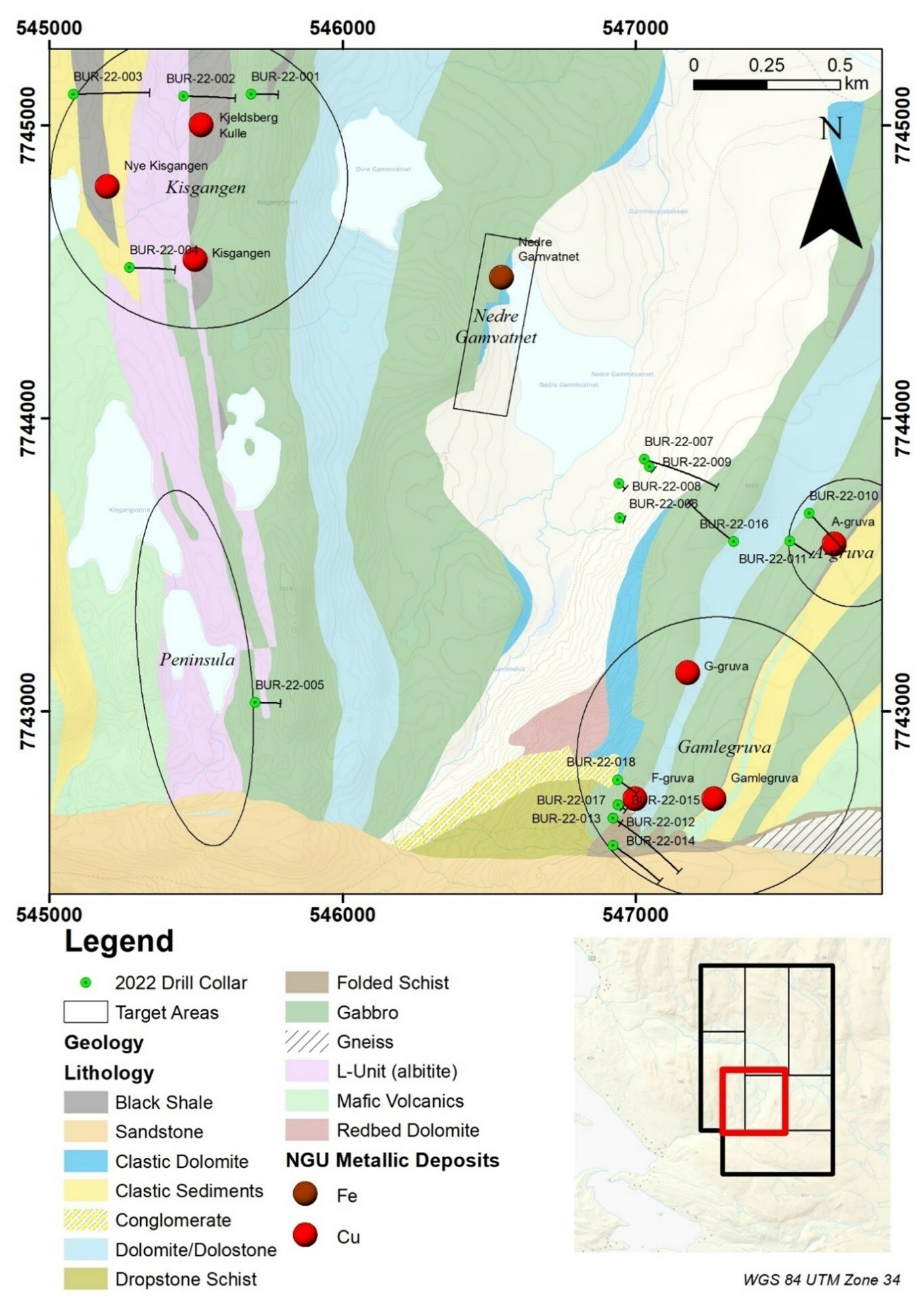
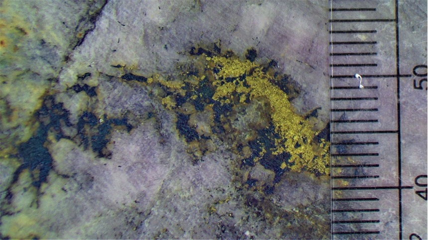
Norden Crown Metals (TSXV:NOCR) has reported new results for its eighteen diamond drill hole reconnaissance program from summer 2022 at the Burfjord copper-gold project. Total 3,499.4 metres, the drill results included 36 metres of 0.48% copper in hole BUR-22-017, which includes a 3.7-metre intercept with a grade of 2.83% Cu.
Burfjord has many high-grade veins with associated copper-mineralized alterations envelopes measuring roughly 6 km by 4km. The large alteration footprint, along with widespread copper mineralization in historical workings and recently intersected in Norden’s reconnaissance drilling gives the company reason to believe there is potential that it hosts a large bulk tonnage copper deposit.
Patricio Varas, Executive Chairman and CEO, commented in a press release: “Evaluation of the multiple targets and old mine workings throughout the Burfjord project with diamond drilling has confirmed the prospectivity of the observed IOCG system to host high-grade copper within broadly mineralized alteration zones. “The joint Norden/Boliden technical committee team is reviewing the results and is working on plans to follow up the three zones that have emerged as first priority targets. We are excited to follow up the Gamlegruve, F-gruve and Cedarsgruve prospects with further drill testing with the aim to define economic mineral deposits at Bufjord.”
Results from the drill program are as follows:
| Hole | From (m) | To (m) | Length (m) | Cu % | Au ppm |
| ID | Metres | Metres | Metres | % | g/t |
| BUR-22-001 | 59.55 | 61.95 | 2.40 | 2.20 | 0.01 |
| including | 59.55 | 60.40 | 0.85 | 1.12 | 0.01 |
| including | 61.05 | 61.95 | 0.90 | 4.81 | 0.02 |
| BUR-22-003 | 149.50 | 159.50 | 10.00 | 0.13 | 0.02 |
| BUR-22-003 | 343.00 | 348.15 | 5.15 | 0.14 | 0.04 |
| BUR-22-003 | 365.30 | 365.80 | 0.50 | 1.02 | 0.14 |
| BUR-22-004 | 8.20 | 10.20 | 2.00 | 0.33 | 0.07 |
| BUR-22-004 | 22.00 | 37.50 | 15.50 | 0.23 | 0.07 |
| BUR-22-004 | 176.00 | 181.70 | 5.70 | 0.21 | 0.01 |
| BUR-22-007 | 136.70 | 139.50 | 2.80 | 0.15 | 0.01 |
| BUR-22-007 | 197.00 | 203.05 | 6.05 | 0.26 | 0.07 |
| including | 201.80 | 203.05 | 1.25 | 0.89 | 0.25 |
| BUR-22-007 | 239.40 | 244.29 | 4.80 | 0.13 | 0.03 |
| BUR-22-010 | 52.70 | 55.10 | 2.40 | 0.28 | 0.06 |
| BUR-22-010 | 188.80 | 220.00 | 31.2 | 0.11 | 0.01 |
| Including | 188.80 | 190.00 | 1.20 | 0.41 | 0.02 |
| Including | 206.00 | 212.75 | 6.75 | 0.16 | 0.01
|
| BUR-22-011 | 109.00 | 119.70 | 10.70 | 0.12 | 0.01 |
| Including | 117.50 | 119.70 | 2.20 | 0.28 | 0.02 |
| BUR-22-011 | 146.70 | 148.25 | 1.55 | 0.61 | 0.11 |
| BUR-22-012 | 1.00 | 24.00 | 23.00 | 0.37 | 0.13 |
| Including | 11.00 | 20.00 | 9.00 | 0.68 | 0.29 |
| Including | 13.00 | 18.00 | 3.00 | 0.92 | 0.49 |
| BUR-22-012 | 162.70 | 173.00 | 10.30 | 0.36 | 0.13 |
| Including | 162.70 | 169.90 | 7.20 | 0.47 | 0.15 |
| BUR-22-012 | 305.80 | 306.30 | 0.50 | 1.39 | 1.27 |
| BUR-22-013 | 3.40 | 6.40 | 3.00 | 0.16 | 0.01 |
| BUR-22-013 | 15.70 | 24.00 | 8.30 | 0.38 | 0.06 |
| BUR-22-013 | 136.00 | 138.00 | 2.00 | 0.46 | 0.03 |
| BUR-22-014 | 260.50 | 264.00 | 3.50 | 0.32 | 0.20 |
| BUR-22-014 | 260.50 | 262.00 | 1.50 | 0.63 | 0.37 |
| BUR-22-014 | 311.50 | 316.80 | 5.30 | 0.14 | 0.01 |
| BUR-22-015 | 21.20 | 36.00 | 14.80 | 0.18 | 0.07 |
| Including | 21.20 | 22.20 | 1.00 | 1.56 | 0.28 |
| BUR-22-016 | 251.50 | 270.70 | 19.20 | 0.33 | 0.09 |
| including | 253.00 | 264.20 | 11.20 | 0.41 | 0.11 |
| Including | 253.00 | 255.90 | 2.90 | 0.67 | 0.20 |
| BUR-22-017 | 23.40 | 59.40 | 36.00 | 0.48 | 0.05 |
| Including | 23.40 | 28.70 | 5.30 | 0.31 | 0.13 |
| Including | 32.00 | 39.30 | 7.30 | 0.47 | 0.03 |
| Including | 48.30 | 55.90 | 7.60 | 1.50 | 0.05 |
| Including | 48.30 | 52.00 | 3.70 | 2.83 | 0.07 |
| BUR-22-018 | 18.95 | 79.20 | 60.25 | 0.12 | 0.01 |
| BUR-22-018 | 18.95 | 21.80 | 2.85 | 0.40 | 0.02 |
| Including | 32.30 | 33.20 | 0.90 | 0.38 | 0.02 |
| Including | 46.20 | 48.80 | 2.60 | 0.20 | 0.02 |
| Including | 69.00 | 79.20 | 10.20 | 0.27 | 0.02 |
| Table 1. Burfjord 2022 drill intersects. | |||||
| *Lengths reported as seen in drill core. True widths are estimated at 85-100% of reported lengths. | |
| No significant results were obtained from BUR-22-002 and BUR-22-005. Holes BUR-22-006, BUR-22-008 and BUR-22-009 failed in thick overburden. |
Only limited exploration has taken place at Burfjord in the modern era before Norden Crown’s recent reconnaissance drill programs. The best historical drill intercept consists of 7 metres @ 3.6% copper1 and was obtained from the Cedarsgruve (mine) area in the northern portion of the claim block. Previous drilling at the Gamlegruve area by Norden Crown at Burfjord returned compelling results including an intercept of 32 metres averaging 0.56% copper and 0.26 g/t gold (including 3.46 metres of 4.31% copper and 2.22 g/t gold) at shallow depths below a cluster of historical mine workings2,3.
2022 Focus
Diamond drilling this year has focused on a newly identified, mineralized zone at F-gruve (Figure 1). Three target areas, described below, are now being prioritized for follow-up drilling to test for continuity and grade to define mineral resources. Results at the Gamlegruve zone and parallel F-gruve zone in the south-east limb of the Bergmark anticline have returned the most interesting copper mineralized and altered zones this year.
F-gruve
Drilling this year has delineated a consistently copper and gold mineralized zone along strike from the F-gruve historical working, from surface to shallow depths (Figure 1). Only 140 metres of strike length along an 800-metre mapped trend of vein and breccia hosted copper mineralization has been drill tested this year. The zone remains untested at depth and the Company has particular interest towards the south, where the Caledonian nappe complex covers the gabbro unit which is host to the copper mineralization. The 2021 magnetic survey conducted by Norden Crown reveals the presence of the gabbro unit, below the Caledonides, extending south for over 1 kilometre. Norden Crown and Boliden are reviewing the results from drilling at the F-gruve target and are contemplating plans to continue testing the extent, thickness, and grade of the mineralized zone with further drilling.
The mineralization at F-gruve consists of numerous magnetite-jasper-carbonate-hematite-bornite-chalcopyrite veins, surrounded by an envelope of carbonate-magnetite-hematite-quartz-chalcopyrite-bornite vein stockwork and breccias. The IOCG style of mineralization leaves the company compelled to continue exploration efforts in 2023, where a follow-up program is envisaged for the late winter season.
A list of significant intercepts at F-gruve include:
| Hole | From (m) | To (m) | Length (m) | Cu % | Au ppm |
| ID | Metres | Metres | Metres | % | g/t |
| BUR-21-005 | 115.40 | 118.50 | 3.10 | 3.81 | 0.31 |
| BUR-22-012 | 1.00 | 24.00 | 23.00 | 0.37 | 0.13 |
| Including | 11.00 | 20.00 | 9.00 | 0.68 | 0.29 |
| Including | 13.00 | 18.00 | 3.00 | 0.92 | 0.49 |
| BUR-22-013 | 3.40 | 6.40 | 3.00 | 0.16 | 0.01 |
| BUR-22-013 | 15.70 | 24.00 | 8.30 | 0.38 | 0.06 |
| BUR-22-015 | 21.20 | 36.00 | 14.80 | 0.18 | 0.07 |
| Including | 21.20 | 22.20 | 1.00 | 1.56 | 0.28 |
| BUR-22-017 | 23.40 | 59.40 | 36.00 | 0.48 | 0.05 |
| Including | 23.40 | 28.70 | 5.30 | 0.31 | 0.13 |
| Including | 32.00 | 39.30 | 7.30 | 0.47 | 0.03 |
| Including | 48.30 | 55.90 | 7.60 | 1.50 | 0.05 |
| Including | 48.30 | 52.00 | 3.70 | 2.83 | 0.07 |
| BUR-22-018 | 18.95 | 79.20 | 60.25 | 0.12 | 0.01 |
| Including | 18.95 | 21.80 | 2.85 | 0.40 | 0.02 |
| Including | 32.30 | 33.20 | 0.90 | 0.38 | 0.02 |
| Including | 46.20 | 48.80 | 2.60 | 0.20 | 0.02 |
| Including | 69.00 | 79.20 | 10.20 | 0.27 | 0.02 |
| Table 2. A list of drill intercepts at F-gruve. | |||||
Gamlegruve
Mineralization at Gamlegruve has returned intercepts including a 17.2-metre intercept with a grade of 0.34% copper and a parallel zone grading 0.24% Copper over 24.7m including 3.4m of 0.47% Copper in hole BUR-21-004. An intercept grading 0.51% Copper over 8.8m was also intercepted in hole BUR-21-006. The sheet-like zones of mineralization at Gamlegruve consist of carbonate and quartz stockwork veining containing chalcopyrite, magnetite, and pyrite mineralization. The sheets of mineralization are hosted in an albite altered gabbro sill unit and occur sub-parallel and close to the eastern boundary of the intrusive unit. The mineralized zone is also visible from the surface scars of significant historical mining activities at Gamlegruve along the mineralized trend (Figure 1). Hole BUR-22-012, intersected mineralization from both the F-gruve and Gamlegruve mineralized trends. The hole demonstrates the presence of copper mineralization 100m south of the extent of the Gamlegruve historical mine workings.
A list of significant intercepts at Gamlegruve include:
| Hole | From (m) | To (m) | Length (m) | Cu % | Au ppm |
| ID | Metres | Metres | Metres | % | g/t |
| BUR-21-004 | 141.30 | 158.50 | 17.20 | 0.34 | 0.04 |
| BUR-21-004 | 182.30 | 207.00 | 24.70 | 0.24 | 0.04 |
| BUR-21-006 | 69.35 | 78.15 | 8.80 | 0.51 | 0.17 |
| BUR-22-012 | 162.70 | 173.00 | 10.3 | 0.36 | 0.13 |
| Including | 162.70 | 169.90 | 7.20 | 0.47 | 0.15 |
| BUR-22-012 | 305.80 | 306.30 | 0.50 | 1.39 | 1.27 |
| BUR-22-014 | 260.50 | 264.00 | 3.50 | 0.32 | 0.20 |
| Including | 260.50 | 262.00 | 1.50 | 0.63 | 0.37 |
| Table 3. A list of drill intercepts at Gamlegruve. | |||||
Cedarsgruve
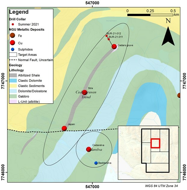
Mineralization at Cedarsgruve has returned some historical intercepts including a 7-metre intercept with a grade of 3.6% copper. Norden followed that last year with a 12m intercept with a grade of 1.27% copper in hole BUR-21-0114. Mineralization at Cedarsgruve occurs as disseminations and fine networks of chalcopyrite and pyrite hosted within an intensely albite altered fine sedimentary package, sandwiched between two intrusive gabbro units, which contain vein hosted copper mineralization. The sedimentary package has seen historical mining in numerous places along its surface expression (Cedars gruve, Japan gruve, and Strix workings) (Figure 2) which demonstrates the presence of a mineralized trend at least 1km in length on surface. Norden is considering the use of ground electromagnetics at Cedarsgruve to delineate the presence and form of chalcopyrite networks below surface within the sedimentary package before further drill testing.
| Hole ID | Depth | Azimuth | Inclination | Grid | Northing | Easting | Elevation
(metres) |
| ID | Metres | Degrees | Degrees | ||||
| BUR-22-001 | 140 | 90 | -50 | WGS 84 / UTM zone 34N | 7745106 | 545690 | 521 |
| BUR-22-002 | 272 | 90 | -50 | WGS 84 / UTM zone 34N | 7745099 | 545459 | 490 |
| BUR-22-003 | 368 | 90 | -50 | WGS 84 / UTM zone 34N | 7745106 | 545083 | 541 |
| BUR-22-004 | 236.5 | 90 | -50 | WGS 84 / UTM zone 34N | 7744514 | 545274 | 526 |
| BUR-22-005 | 140.2 | 90 | -50 | WGS 84 / UTM zone 34N | 7743030 | 545703 | 527 |
| BUR-22-006 | 28 | 110 | -50 | WGS 84 / UTM zone 34N | 7743661 | 546947 | 449 |
| BUR-22-007 | 392.5 | 110 | -50 | WGS 84 / UTM zone 34N | 7743860 | 547031 | 444 |
| BUR-22-008 | 42 | 130 | -50 | WGS 84 / UTM zone 34N | 7743777 | 546945 | 440 |
| BUR-22-009 | 29 | 130 | -50 | WGS 84 / UTM zone 34N | 7743835 | 547048 | 446 |
| BUR-22-010 | 230.5 | 120 | -50 | WGS 84 / UTM zone 34N | 7743676 | 547594 | 525 |
| BUR-22-011 | 172 | 120 | -60 | WGS 84 / UTM zone 34N | 7743582 | 547527 | 520 |
| BUR-22-012 | 464.5 | 125 | -50 | WGS 84 / UTM zone 34N | 7742636 | 546925 | 585 |
| BUR-22-013 | 111.5 | 125 | -75 | WGS 84 / UTM zone 34N | 7742636 | 546925 | 585 |
| BUR-22-014 | 317.5 | 125 | -50 | WGS 84 / UTM zone 34N | 7742543 | 546924 | 572 |
| BUR-22-015 | 52.9 | 125 | -50 | WGS 84 / UTM zone 34N | 7742682 | 546941 | 589 |
| BUR-22-016 | 310.3 | 305 | -50 | WGS 84 / UTM zone 34N | 7743580 | 547336 | 515 |
| BUR-22-017 | 69 | 125 | -75 | WGS 84 / UTM zone 34N | 7742682 | 546941 | 589 |
| BUR-22-018 | 123 | 125 | -50 | WGS 84 / UTM zone 34N | 7742767 | 546939 | 584 |
| Table 4. Burfjord 2022 drill collar information. | |||||||
The above references an opinion and is for information purposes only. It is not intended to be investment advice. Seek a licensed professional for investment advice. The author is not an insider or shareholder of any of the companies mentioned above.
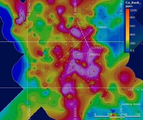
Rugby Resources (TSXV:RUG) initiated drilling at the Cobrasco discovery in Colombia in August 2022, starting with the third drill hole CDH0003 of 300.6 metres, planned to be drilled to 1,300m when drilling resumes. Rugby Resources is the first company to drill test the Cobrasco porphyry system.
Currently, drilling is paused due to elevated costs related to helicopter-supported activity and difficult global capital markets. In search of a financing option that will be minimally dilutive, Rugby Resources is pursuing a strategic investor and anticipates that drilling might resume in late Q1 2023.
Ruby expects assays from drillholes CDH002 and CDH 003 in early to mid January 2023. Drillhole CDH002 was target due to surface geochemistry and the positive results received from CDH001 (the first drillhole), which reported 82m at 1.00% CuEq¹ within a broader interval of 808m of 0.46% CuEq¹. CDH002 was located 400m south of CDH001 and intersected a wide interval of copper-molybdenum mineralized diorite porphyry before it terminated at 946.1m within a wide fault zone.
From there, the third drillhole, CDH003, was collared from the same drill platform. Rugby drilled in a northerly direction, testing the upper mineralized part of CDH001 to a greater depth this time. The company encountered disseminated and veined copper-molybdenum mineralization from near surface above the target depth, and the intensity of the mineralization increased to the current depth of 300.6m.
The mineralization intersected to-date at Cobrasco is bornite dominant with lesser chalcopyrite and molybdenite, while penalty elements remain low. The company expects the mineralization to be amenable to the production of a high-grade copper concentrate based on this mineralogy. The preliminary metallurgical testwork for documenting the metallurgy is planned when operations resume. The company plans to continue the geological mapping and geochemical surveys with the goal of identifying the porphyry centres in the Cobrasco intrusive complex at the deposit.
Rugby’s Cobrasco Project Manager, Francisco Montes, commented in a press release: “CDH002 intersected disseminated copper-molybdenum mineralisation as soon as it entered fresh rock below the drill collar. Metal veining was increasing in the lower sections of the hole. CDH003 shows strong mineralisation from approximately the same level as CDH002. I am confident that such mineralisation will be shown to continue down to the primary target zone when drilling resumes in 2023.
“Mineralisation has now been intersected in a triangular area through drill holes CDH001, CDH002 and CDH003. Strong surface geochemistry indicates a much broader lateral extent to mineralisation than the area tested by the three holes. I have recommended that we make drill testing such extensions a priority in 2023.
“For the next few months in Q1 2023, Rugby’s field exploration program will take precedence with additional geological mapping, rock and soil sampling and general prospecting activities. I am confident this program will define additional porphyry targets.’’
Table 1 – Collar Location
| HOLE | E | N | RL | Az T | DIP | DEPTH m | REMARKS |
| CDH001 | 342339 | 658730 | 340 | 223.5 | 50 | 1,036.4 | Hole terminated |
| CDH002 | 342292 | 658333 | 361 | 260.0 | 70 | 946.1 | Hole prematurely terminated |
| CDH003 | 342292 | 658333 | 361 | 330.0 | 67 | 300.6 | Current depth as at Dec 29, 2022 |
The above references an opinion and is for information purposes only. It is not intended to be investment advice. Seek a licensed professional for investment advice. The author is not an insider or shareholder of any of the companies mentioned above.
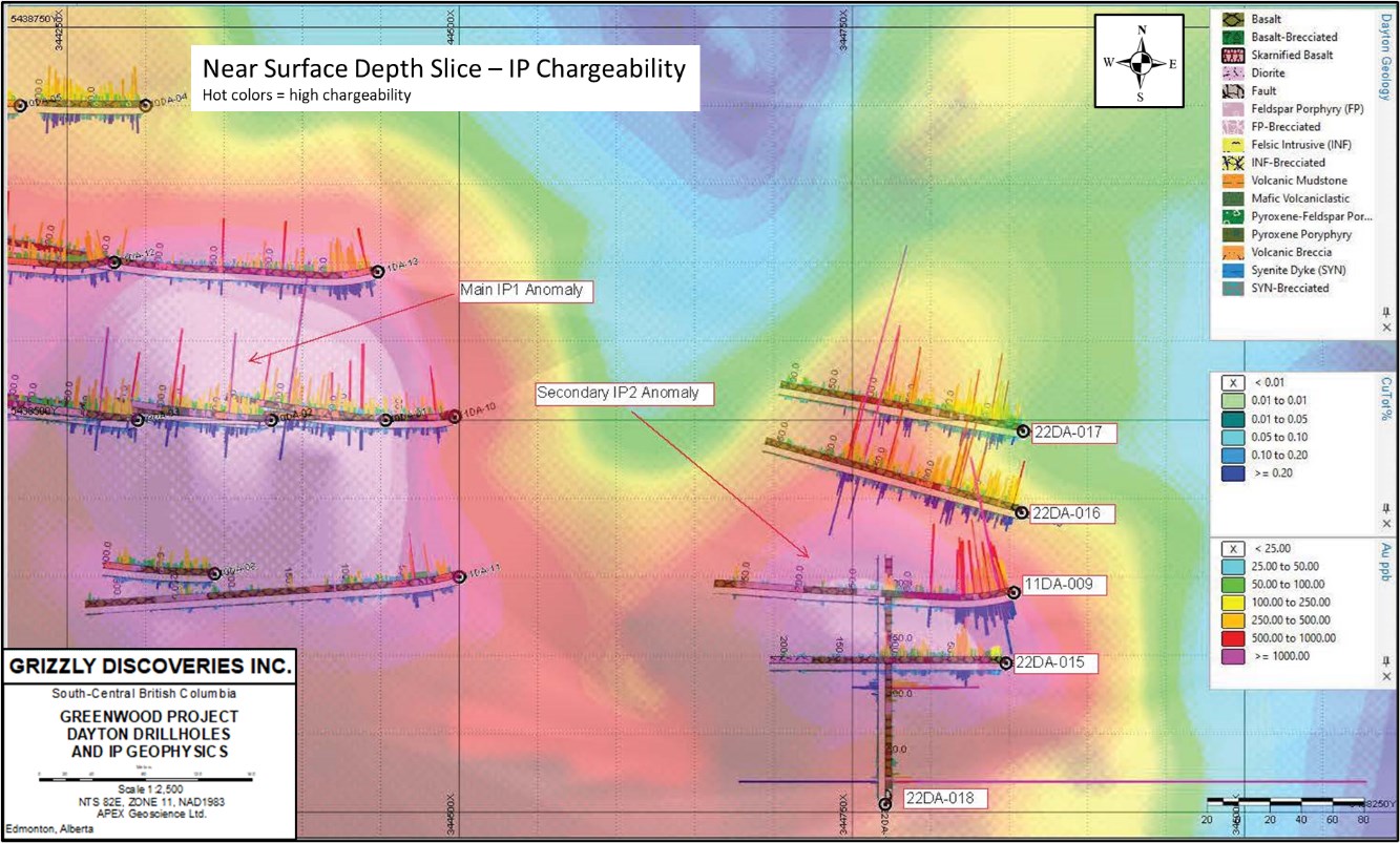
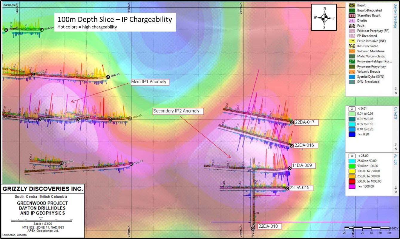
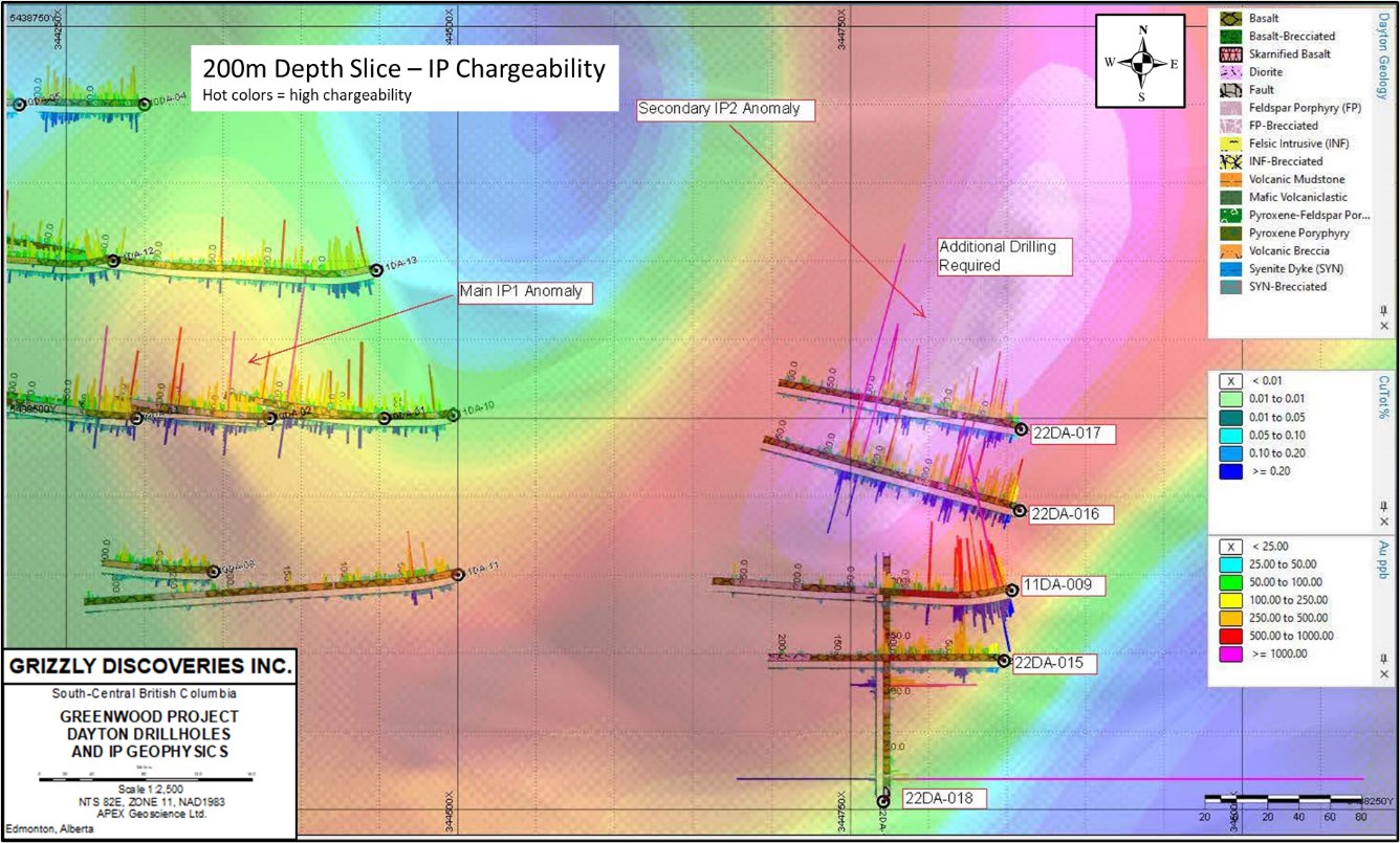
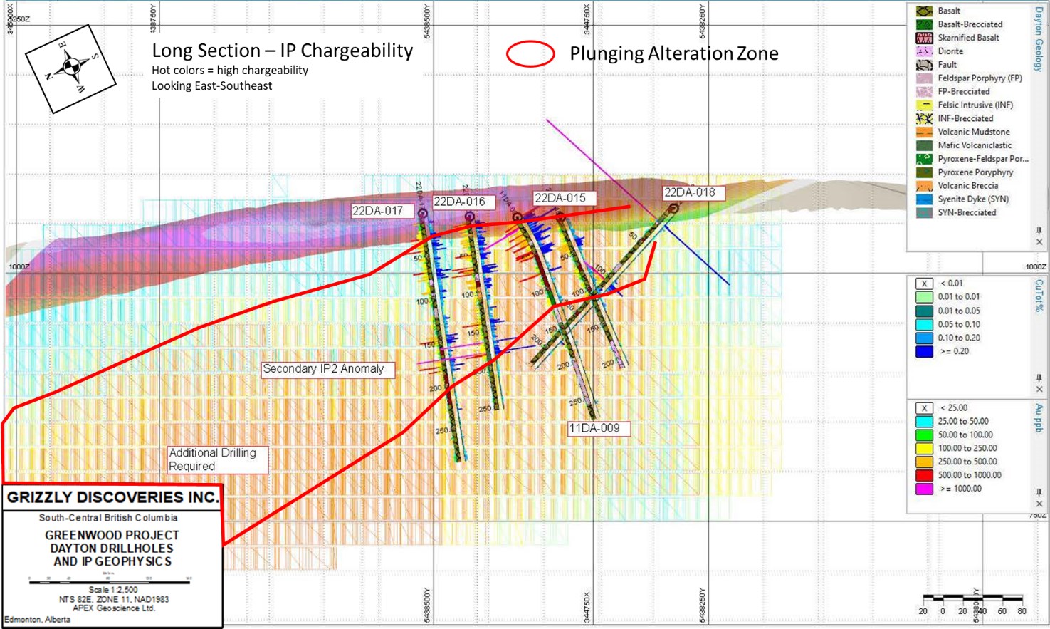
Grizzly Discoveries (TSXV:GZD) has reported new assay results from the first four core holes completed at the Dayton Target area during its Phase 1 drill program at the Greenwood Project in British Columbia. The company has completed 3,123m in 15 core holes and is waiting for results for 11 other holes. Further drilling is currently planned for the Dayton IP1 anomaly, and will begin shortly as permits are already secured.
Brian Testo, President and CEO of Grizzly Discoveries, commented in a press release: “The early stage drill program at Dayton successfully intersected large intervals of copper, gold, and silver bearing altered and mineralized volcanic and diorite intrusive rocks; an encouraging positive step forward for a project that has seen little systematic exploration in the past. We are eager to resume drilling to expand this exciting discovery.”
Highlights from the drill program results are as follows:
- The Company completed 4 core holes for 1,014 m at the copper-gold Dayton Skarn/Porphyry Prospect (Figures 1 and 2) following up a discovery by Grizzly in 2011 at Dayton.
- The Dayton IP2 target (an induced polarization [IP] chargeability anomaly) was tested by Grizzly with a single hole in 2011 and intersected potassic altered volcanics and dioritic intrusives with a near surface intersection (11DA-009) of 0.15% copper (Cu) and 0.43 grams per tonne (g/t) gold (Au) (or 0.46% CuEq**) over 51 m core length starting at a depth of 3 m (Table 1).
- Comparable and thicker sulphide zones, skarn and potassic alteration have been intersected in the 2022 drilling at the Dayton IP2 target (Figure 2).
- New intersections at Dayton include hole 22DA-016 with 0.062% Cu, 0.221 g/t Au and 1.89 g/t Ag (0.221% CuEq**) over 180 m core length, 22DA-017 with 0.057% Cu, 0.149 g/t Au and 1.76 g/t Ag (0.177% CuEq**) over 184 m core length, and 22DA-015 with 0.033% Cu, 0.155 g/t Au and 2.06 g/t Ag (0.162% CuEq**) over 44.5 m core length.
- Intercepts are all associated with an IP chargeability anomaly (IP2) and mineralization appears to plunge and thicken to the northeast down plunge in conjunction with an apparent plunge of the IP chargeability anomaly (Figures 3 to 7). The IP2 anomaly is at least 600 m in strike length and ranges from 100 to 150 m wide and is open to the northeast and at depth.
- Further drilling is planned for the Dayton IP2 chargeability anomaly. Permits are already in place to conduct further drilling.
Table 1: Dayton Summary drillhole results 2022.
| DH | From m | To m | Width m* | Au ppm | Ag ppm | Cu % | CuEq%** |
| 22DA-015 | 6 | 50.5 | 44.5 | 0.155 | 2.06 | 0.033 | 0.162 |
| 22DA-016 | 7 | 187 | 180 | 0.201 | 1.89 | 0.062 | 0.221 |
| includes | 7 | 94 | 87 | 0.222 | 1.41 | 0.081 | 0.251 |
| 22DA-017 | 9 | 184 | 175 | 0.149 | 1.76 | 0.057 | 0.177 |
| 22DA-018 | 20 | 21 | 1 | 6.05 | 15.30 | 0.026 | 4.445 |
| and | 98 | 113 | 15 | 0.261 | 2.65 | 0.023 | 0.231 |
| includes | 103 | 111 | 8 | 0.419 | 2.60 | 0.021 | 0.341 |
| 11DA-009*** | 3 | 54 | 51 | 0.43 | 0.81 | 0.15 | 0.462 |
*Core length as true thickness is unknown at this stage of exploration. **CuEq calculated using ratios of Au:Cu 1:7,080 and Ag:Cu 1:88.5.
***Previously reported in 2011
The above references an opinion and is for information purposes only. It is not intended to be investment advice. Seek a licensed professional for investment advice. The author is not an insider or shareholder of any of the companies mentioned above.
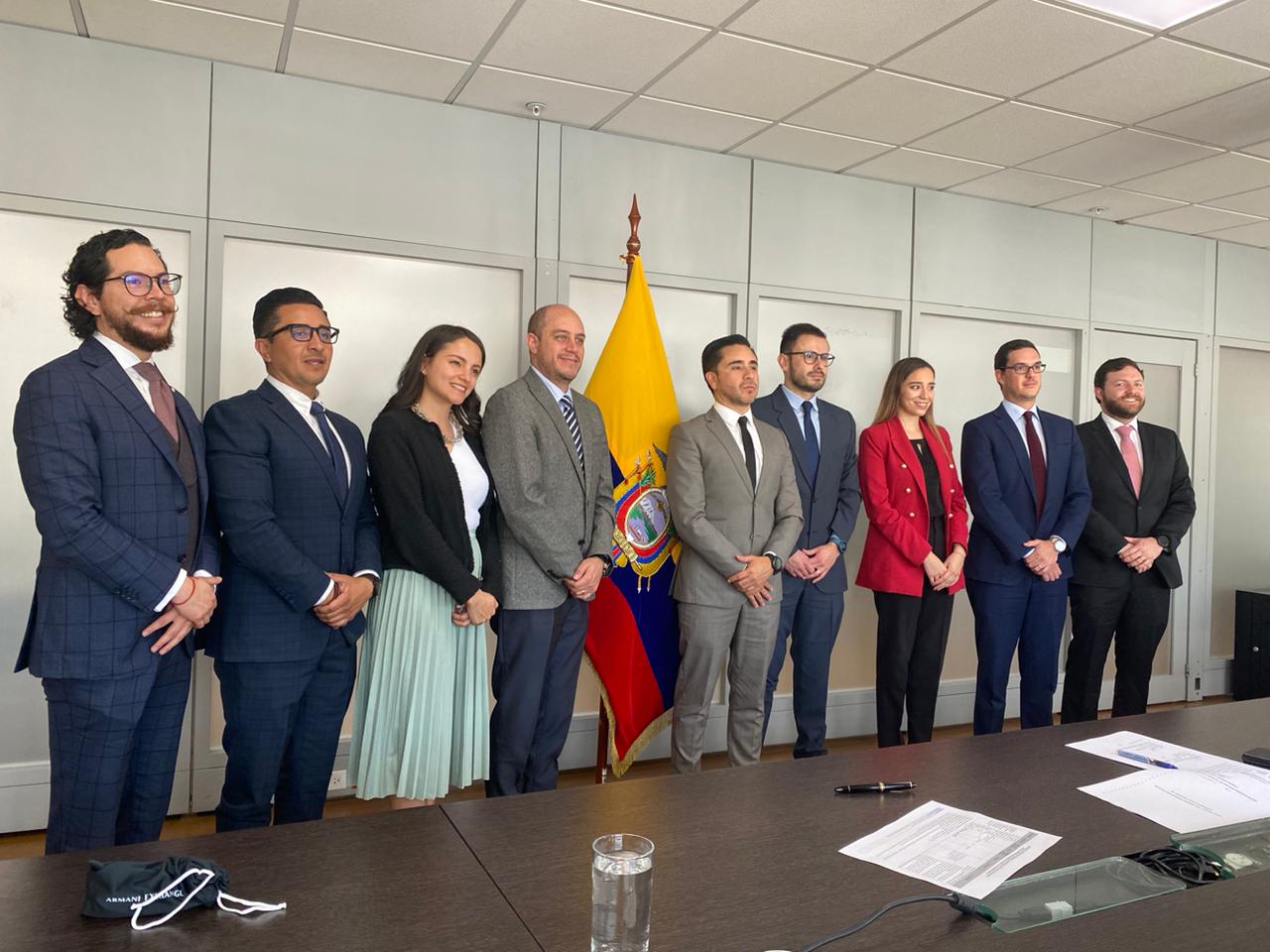
Solaris Resources (TSX:SLS) (OTCQB:SLSSF) has announced that a major Investment Contract for the Warintza Project has been signed. The contract ratifies the Investment Protection Agreement announced on June 9, 2022. The IPA provides a strong foundation of certainty for the company as it relates to the legal framework governing the project, including stable mining regulations, security of title and investment, and new tax incentives to accelerate development.
It includes specific protections related to the prohibitions of all forms of confiscation, non-discriminatory treatment, legal security, and tax stability. The agreement notes a 5% income tax reduction, fixes the income tax rate at 20% and includes an exemption from capital outflow tax and import duties for the import of goods needed for new investments. It also includes important detailed procedures for the dispute resolution process and stipulations for international arbitration protection.
Mr. Daniel Earle, President & CEO, commented: “We are very grateful to the Government of Ecuador and our host communities for their support in reaching this major milestone. The Investment Contract provides a foundation of certainty, significantly de-risking the Warintza Project by securing a stable regulatory and fiscal framework with international legal protections for the Project while also enhancing its returns through permanent new tax incentives.”
Mr. Julio José Prado, Minister of Production, Foreign Trade, Investment, and Fisheries of the Government of Ecuador, stated, “I want to thank Solaris for the commitment with the country and with Morona Santiago, it is an example of sustainable mining, responsible with the environment and the communities. Since the first contacts in the Ecuador Open for Business event, we have worked for a year and today we signed the Investment Contract. The Warintza Project has a very important influence, and they are working with the community in an exemplary manner; this will allow more development and prosperity for the zone and for Ecuador.”
Mr. Fernando Santos Alvite, Minister of Energy and Mines of the Government of Ecuador, stated, “I wish the best of success to the Warintza Project. This is a very important project for the country in terms of scale and investment. It is also important for what it represents, which is a great commitment and understanding between the communities and the Company.”
Mr. Vicente Tsakimp, Lead Coordinator of the Warintza Project Strategic Alliance, stated, “The Warints and Yawi Shuar Centers are glad that the Warintza Project is advancing and that we are part of it. Our work and coordination with the Company are an example that participatory mining can be done, and we are proud of everything we have achieved.”
Highlights from the agreement are as follows:
The Investment Contract provides for the following protections and incentives for the duration of the title of the Project which extends with renewal to 2066:
- Security of investment
- Stability of mining law
- Stability of taxes at a reduced income tax rate of 20% (25% previously)
- Exemption from capital outflow tax (5% previously)
- Exemption from import duties (up to 5% previously)
- Detailed procedures for dispute resolution and international arbitration protection
The above references an opinion and is for information purposes only. It is not intended to be investment advice. Seek a licensed professional for investment advice. The author is not an insider or shareholder of any of the companies mentioned above.
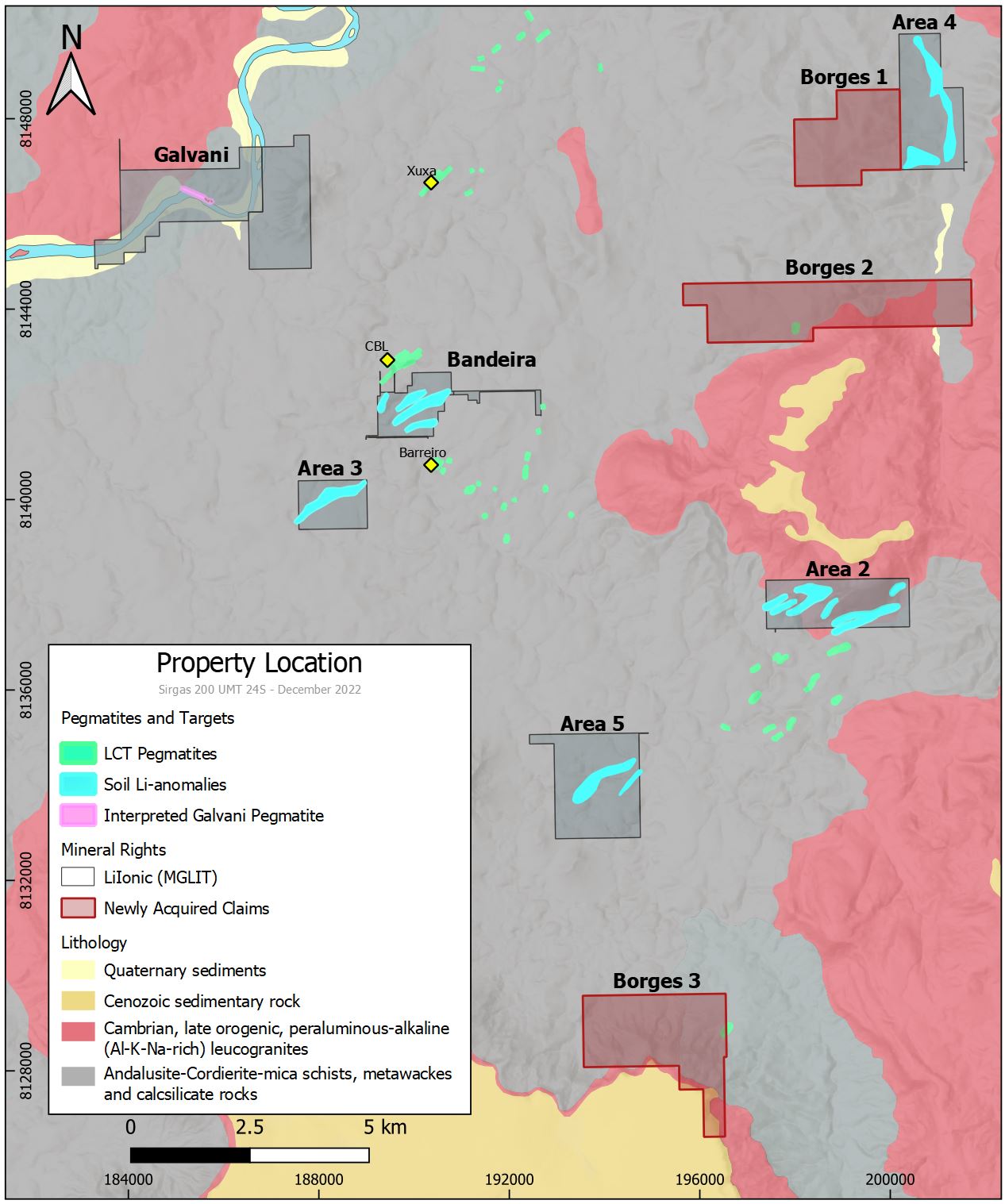
Lithium Ionic (TSXV:LTH) has reported new assay results from its ongoing drilling program at the 100%-owned Bandeira property in Brazil. Located approximately 800m south of the lithium-producing CBL mine and roughly 800m north of Sigma Lithium’s Grotado Cirilo property, the Bandeira property is the largest lithium hardrock deposit in the Americas.
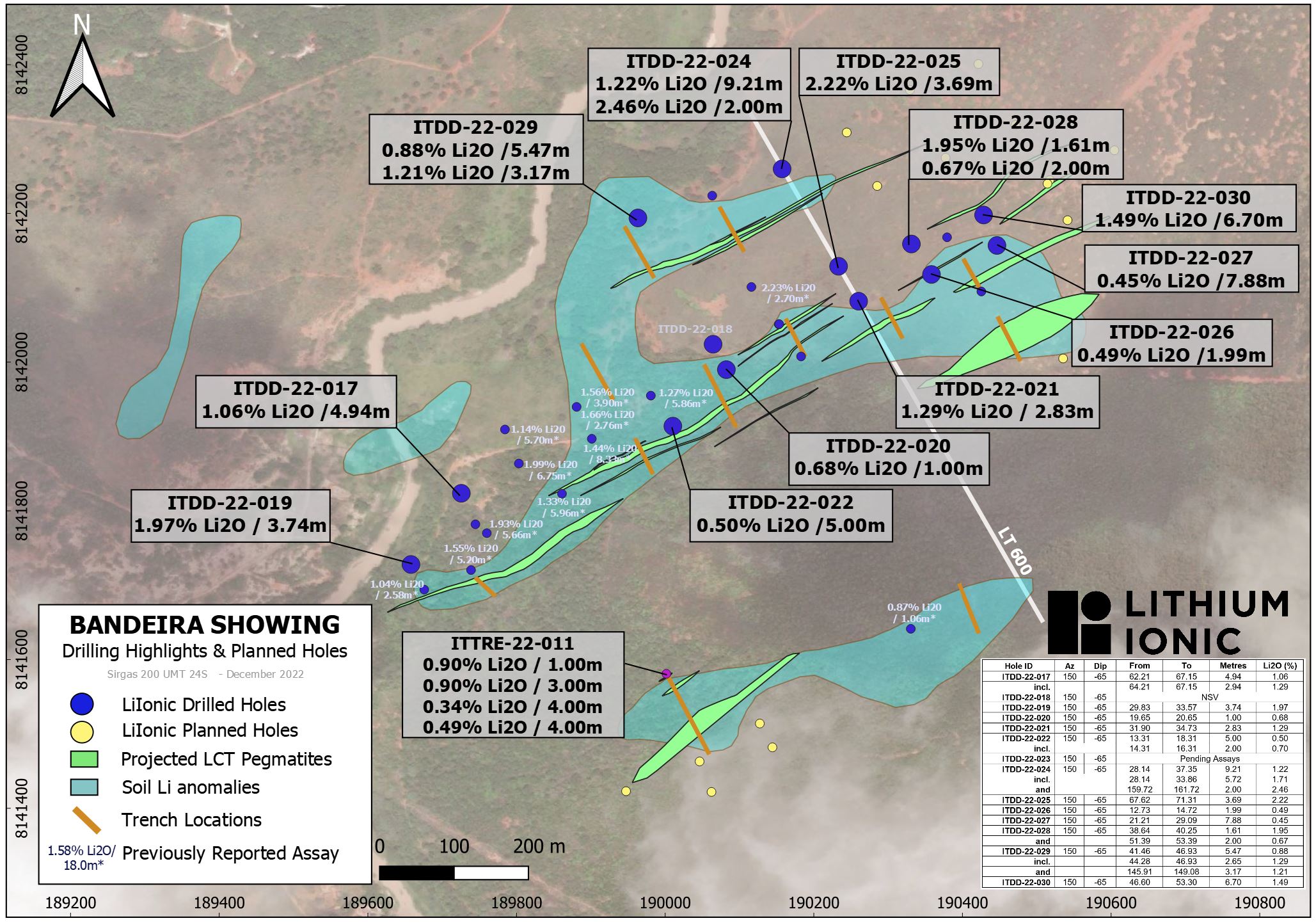
The Bandeira drilling program is focusing on mineralization close to the surface that is connected to a 1.3 km line of multiple lithium soil anomalies. The Company is energetically using five drills and is still on schedule to present a NI 43-101 compliant mineral resource estimate in the beginning of 2023.
Bandeira is situated 800m to the south of the working CBL lithium mine and 800m to the north of Sigma Lithium’s Barreiro project which is in the construction phase. Pegmatite/spodumene deposits with lithium-bearing characteristics in this region known for its mining activity, are known to be of high-grade and high-grade quality, as evidenced by the near-by lithium producer and the published metallurgical results from bordering properties.
Blake Hylands, Chief Executive Officer of Lithium Ionic, commented in a press release: “We are very encouraged by the excellent results coming from Bandeira. The definition of mineralization is improving significantly as we continue to identify new parallel zones of mineralized pegmatites at surface as well as down dip from existing zones.”
Highlights from the results are as follows:
- 1.22% Li2O over 9.2m, incl. 1.71% Li2O over 5.7m;
and 2.46% Li2O over 2m (hole ITDD-22-024) - 1.49% Li2O over 6.7m (hole ITDD-22-030)
- 2.22% Li2O over 3.7m (hole ITDD-22-025)
- 1.97% Li2O over 3.7m (hole ITDD-22-019)
Previously announced drill highlights from Bandeira include:
- 1.44% Li2O over 8.33m (hole ITDD-22-012)
- 1.99% Li2O over 6.75m (hole ITDD-22-011)
- 1.93% Li2O over 5.66m (hole ITDD-22-002)
- 1.55% Li2O over 5.2m (hole ITDD-22-001)
- 1.56% Li2O over 3.90m and 1.66 Li2O over 2.76 (hole ITDD-22-013)
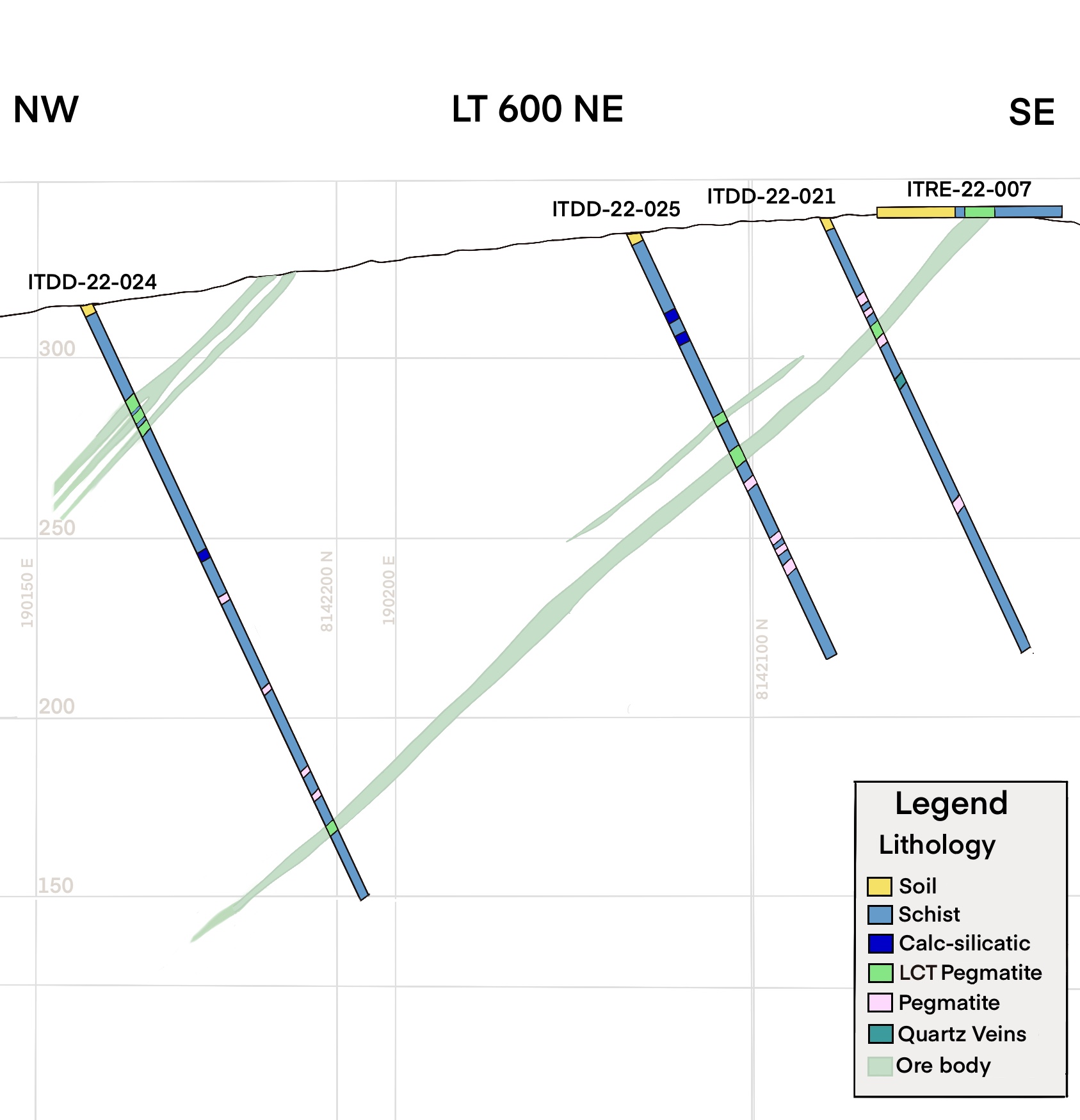
Table 1. Bandeira Drill Results
| Hole ID | Az | Dip | From | To | Metres | Li2O (%) |
| ITDD-22-017 | 150 | -65 | 62.21 | 67.15 | 4.94 | 1.06 |
| incl. | 64.21 | 67.15 | 2.94 | 1.29 | ||
| ITDD-22-018 | 150 | -65 | NSV | |||
| ITDD-22-019 | 150 | -65 | 29.83 | 33.57 | 3.74 | 1.97 |
| ITDD-22-020 | 150 | -65 | 19.65 | 20.65 | 1.00 | 0.68 |
| ITDD-22-021 | 150 | -65 | 31.90 | 34.73 | 2.83 | 1.29 |
| ITDD-22-022 | 150 | -65 | 13.31 | 18.31 | 5.00 | 0.50 |
| incl. | 14.31 | 16.31 | 2.00 | 0.70 | ||
| ITDD-22-023 | 150 | -65 | Assays Pending | |||
| ITDD-22-024 | 150 | -65 | 28.14 | 37.35 | 9.21 | 1.22 |
| incl. | 28.14 | 33.86 | 5.72 | 1.71 | ||
| and | 159.72 | 161.72 | 2.00 | 2.46 | ||
| ITDD-22-025 | 150 | -65 | 67.62 | 71.31 | 3.69 | 2.22 |
| ITDD-22-026 | 150 | -65 | 12.73 | 14.72 | 1.99 | 0.49 |
| ITDD-22-027 | 150 | -65 | 21.21 | 29.09 | 7.88 | 0.45 |
| ITDD-22-028 | 150 | -65 | 38.64 | 40.25 | 1.61 | 1.95 |
| and | 51.39 | 53.39 | 2.00 | 0.67 | ||
| ITDD-22-029 | 150 | -65 | 41.46 | 46.93 | 5.47 | 0.88 |
| incl. | 44.28 | 46.93 | 2.65 | 1.29 | ||
| and | 145.91 | 149.08 | 3.17 | 1.21 | ||
| ITDD-22-030 | 150 | -65 | 46.60 | 53.30 | 6.70 | 1.49 |
The above references an opinion and is for information purposes only. It is not intended to be investment advice. Seek a licensed professional for investment advice. The author is not an insider or shareholder of any of the companies mentioned above.
Lithium Americas (TSX:LAC) has agreed to buy all the shares it doesn’t own of Arena Minerals (TSXV:AN). The deal values Arena at $227 million and will give Lithium Americas expanded access to the Pastos Grandes basin in Argentina. Arena Minerals shareholders will receive 0.0226 of a Lithium Americas common share for every Arena share. After the deal is completed, Arena Minerals investors will own approximately 5.7% of Lithium Americas.
Ganfeng Lithium, GFL International, and their affiliates currently own roughly 16% of Arena Minerals’ outstanding shares, and if their warrants were exercised, this would give them a further 6% stake. Ganfeng has now entered an agreement to dispose of its securities of Arena before the merger closes.
The companies expect the deal to close in Q3 2023, as Lithium Americas is going through a business transformation during this period. The company is looking to separate its North American and Argentine businesses into two separate and independent public companies. The new Lithium Americas company will be led by current CEO Jonathan Evans and will own the Thacker Pass lithium project in Nevada as well as other investments in Ascend Elements and Green Technology Metals (ASX:GTI).
This acquisition will combine the two projects operated by the companies in the Pastos Grandes basin, on the Argentine side of South America’s lithium triangle. Located close to Lithium Americas’ Cauchari-Olaroz, the brine project is expected to enter production in the first half of 2023.
Chief executive officer Jonathan Evans commented in a statement: “The significant synergies between our two projects and a better understanding of the basin will enable us to advance development planning and maximize our growth pipeline in Argentina.”
The second new company will be focused on the assets in Argentina, including Pastos Grandes and Cauchari-Olaroz. The new company will be called Lithium International.
Lithium prices are one of the most resilient commodities, and the acquisition is expected to benefit Lithium Americas in the long-term. The company has been focusing on producing battery-grade lithium, and the acquisition will give them access to more resources and potential opportunities in the lithium market.
Spodumene prices are up 257% YTD, averaging approximately $5,900 per tonne for 6% concentrate Australian free on board price in November 2022. While prices have been rising in 2022 after a very bullish 2021, prices are expected to fall in 2024 as the market stabilizes slightly.
The above references an opinion and is for information purposes only. It is not intended to be investment advice. Seek a licensed professional for investment advice. The author is not an insider or shareholder of any of the companies mentioned above.
The world’s global food supply is highly connected, and it is important that potash producers step up to help ensure global food security. Potash is an essential nutrient for plant growth and development, and without it, crops will not be able to grow to their full potential. By stepping up to support global food security, potash producers can help improve the yield of a crop and its quality, ensuring that it can be used for food production.
This can help to reduce food insecurity and poverty, as well as provide access to more nutritious food for those who need it. It can also help to reduce environmental damage from the overuse of fertilizers and chemicals on crops, helping to protect the planet for future generations.
Countries like Brazil are the perfect example of how boosting domestic potash production could lead to benefits across the entire agriculture sector and beyond. Brazil’s agricultural industry is one of the country’s largest employers, and the potash industry is a major contributor to the country’s economy. However, right now, Brazil is a net importer, and this raises costs for the industry and creates risks to supply chains.
Brazil Potash, a potash mining company, is developing the Autazes Potash Project near Manaus. The goal of the project is to develop a more environmentally-friendly method of extracting potash from the ground while doubling twice the current Brazilian production and changing the domestic potash market dynamic in Brazil.
The Brazilian government has given the project its support, and this year there has been plenty of discussion of the importance of fertilizers to the country. The administration released the National Fertilizer Plan, highlighting the importance of potash in the country’s fertilizer mix.
Brazil Potash’s management team is another reason that this project is such an important one. The team has a strong track record of developing and bringing projects into production. In addition, the company’s board of directors includes advice from representatives from some of the world’s largest agribusiness companies, which provides valuable insights into the industry.
Brazil is not the only country looking to change the potash market. The current market dominance of a few countries including Canada, Russia, and Belarus has left some of the most food-insecure countries in need of a new domestic potash strategy. Across regions like Africa, Asia, and Latin America, potash producers are looking for ways to develop and increase local potash production to provide a more secure supply of the mineral to citizens and agricultural companies.
The other area the Autazes Potash Project solves is the supply chain backlog and dependence on overseas imports. When the pandemic shut down shipping and borders, this created a backlog and increased costs for many countries. By providing a domestic potash supply, Brazil can avoid these issues and ensure its agricultural industry remains productive.
The Autazes Potash project will not only create direct jobs at the site but indirect jobs and other investments in the communities in which it operates and further collaboration with local and national governments. Brazil’s new government has positioned itself as a champion of global trade and investment, and this new political environment will also help the company in its mission to expand and double production as quickly as possible. The company is currently in the pre-production phase and is open for private investment, directly through Brazil Potash.
The future of global food security is uncertain, but it is clear that potash producers will play an important role in helping to ensure that everyone has access to nutritious food. With the Autazes Potash Project, Brazil Potash is paving the way to a more secure and sustainable agricultural future for all Brazilians, and the world.
The above references an opinion and is for information purposes only. It is not intended to be investment advice. Seek a licensed professional for investment advice. The author is not an insider or shareholder of any of the companies mentioned above.
Newcore Gold (TSXV:NCAU) has continued to advance and de-risk the Enchi Gold Project in Ghana, with recent exploration activities building on past preparation work. The company expects a Mineral Resource Estimate to be released sometime in January 2023.
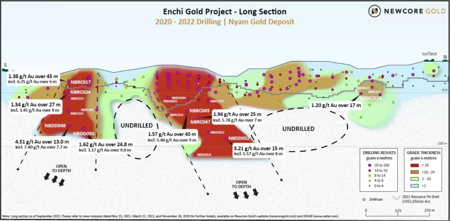
Under the current program, metallurgical test work, including testing of sulphide mineralization, continues, and in the first half of 2023, Newcore expects to complete an environmental and social baseline study. Diamond drilling is currently underway at the important Nyam Gold Deposit at Enchi. This drilling is focused on following up on high-grade results from the upper sulphide mineralization in the past. Newcore Gold is currently funded and ready to complete the current work program at Enchi with a balance in cash and short-term investments of $5 million recorded at the end of Q3 2022.
Luke Alexander, President and CEO of Newcore, commented in a press release: “We continue to be active on numerous fronts advancing and de-risking the Enchi Gold Project. An updated Mineral Resource Estimate, incorporating the significant amount of drilling completed in 2021 and 2022, is targeted for completion in January 2023. We are also thrilled to be back drilling at Enchi with the first phase of this drill program targeting the higher-grade potential of the sulphide mineralization that we first encountered in 2021. Testing the high-grade and depth potential of the sulphide mineralization is a priority as part of defining the potential for gold mineralization at Enchi on the same scale and magnitude as the significant gold deposits along the Sefwi-Bibiani gold belt.”
Highlights from Work Programs and Exploration Underway at Enchi are as follows:
- Mineral Resource Update Underway with Completion in January 2023, incorporating results from a portion of the 90,000 metre drill program completed in mid-2022. From this drilling approximately 20,000 metres was included in the 2021 Mineral Resource Estimate; approximately 40,000 metres was focused on resource expansion and is anticipated to be included in the update; the remaining metres focused on earlier stage targets that highlight the future resource growth potential at Enchi and will be incorporated into future mineral resource updates. Completion of an updated Mineral Resource Estimate is scheduled for January 2023 as the Company’s resource consultant completes incorporation of all new drilling data and recently completed drone topographic surveys. It is anticipated that incorporating the recently completed drone survey will upgrade a portion of the Mineral Resource Estimate into the Indicated category, further de-risking the Project.
- Newcore is funded to complete the current work program at Enchi (commenced October 2022) with $5 million in cash and short-term investments at the end of Q3 2022.
- Drilling Underway Targeting High-Grade Potential at Enchi. Diamond drilling underway at the Nyam Gold Deposit is following-up on high-grade mineralization identified in the upper portions of the sulphide mineralization, continuing to define the potential for high-grade underground mineralization at Enchi. Results anticipated Q1 2023.
- Trenching Intersected Mineralization at Early-Stage Targets, providing additional drill targets for discovery. First pass trenching of kilometre-scale gold-in-soil anomalies encountered strong results in oxidized mineralization with 0.73 grams per tonne gold (“g/t Au”) over 22.0 metres (“m”) at the Nkwanta Target and 0.65 g/t Au over 24.0 m at the Agyeikrom Target.
- Metallurgical Testwork and Updated Baseline Environmental and Social Study underway as part of broader activities at Enchi designed to continue to advance and de-risk the Project.
Mineral Resource Update to be Completed January 2023
An updated Mineral Resource Estimate is underway, incorporating results from the 90,000 metre drill program completed in mid-2022. Of the 92,583 metres of drilling completed in 2021 and 2022, the current Mineral Resource Estimate (completed June 2021) incorporated only 20,195 metres of drilling. Of the remaining 72,388 metres the Company anticipates that approximately 40,000 metres will be additive to the resource at Enchi given those metres focused on testing existing deposit areas along strike and at depth. The remaining metres targeted earlier stage targets highlighting the potential for future resource growth at Enchi as Newcore continues to prove out the multi-million-ounce potential of the 216 km2 district scale property. Completion of the updated Mineral Resource Estimate is scheduled for January 2023 as the Company’s consultant completes incorporation of all new drilling data and recently completed drone topographic surveys. It is anticipated that incorporating the recently completed drone survey will upgrade a portion of the Mineral Resource Estimate into the Indicated category, further de-risking the Project.
Table 1 – Enchi Gold Project High Grade Drill Highlights
| Hole ID | Zone/Deposit | From (m) | To (m) | Length (m) | Au (g/t) |
| NBRC045 | Nyam | 179.0 | 219.0 | 40.0 | 1.57 |
| including | 185.0 | 194.0 | 9.0 | 5.40 | |
| NBDD048 | Nyam | 236.0 | 249.0 | 13.0 | 4.51 |
| including | 237.5 | 245.2 | 7.7 | 7.40 | |
| NBRC047 | Nyam | 222.0 | 247.0 | 25.0 | 1.94 |
| including | 227.0 | 234.0 | 7.0 | 5.78 | |
| NBDD052 | Nyam | 321.0 | 336.0 | 15.0 | 3.21 |
| including | 322.0 | 330.0 | 8.0 | 5.57 | |
| NBRC073 | Nyam | 74.0 | 131.0 | 57.0 | 0.78 |
| including | 94.0 | 103.0 | 9.0 | 1.34 | |
| NBRC092 | Nyam | 38.0 | 62.0 | 24.0 | 1.79 |
| including | 51.0 | 55.0 | 4.0 | 4.14 |
Notes:
- See detailed table for complete results
- Intervals reported are hole lengths with true width estimated to be 75 – 85%
- Length-weighted averages from uncut assays
The above references an opinion and is for information purposes only. It is not intended to be investment advice. Seek a licensed professional for investment advice. The author is not an insider or shareholder of any of the companies mentioned above.
Brazil Potash has announced that it is continuing to advance its Autazes potash project toward submission and has submitted an Indigenous Consultation Study (ECI). This accompanies the completion of an update of the engineering technical report. The report outlines projected project costs and economics.
There are a total of 78 items to be completed and approved by several Brazilian government agencies. This will allow the company to obtain an installation license for the project, a requirement for Brazil Potash to begin construction at Autazes. The company has already completed 76 of these items and submitted item 77 (ECI) to the government indigenous rights protection agency, FUNAI.
FUNAI has 90 days to review the proposal and give Brazil Potash a response, ideally an approval. After obtaining approval for the ECI from FUNAI, Brazil Potash will need to provide it to the Amazonas Environmental Protection Institute (IPAAM) and three indigenous support programs: (i) Program of Support to Indigenous Communities, (ii) Program of Social Communication, and (iii) Subprogram of Environmental Education.
With this submission, Brazil Potash is looking for the reinstatement of its Preliminary License from the Court overseeing the process, at which point IPAAM can issue the installation license. Company management has also recently updated the engineering, cost, and economic technical report to provide a current view of key project metrics. This will help the company provide an overview and clear picture ahead of raising funds for construction.
The last comprehensive study was completed in 2016, and as of the 2022 assessment, the company has noted that an escalation in costs for construction capital and general operating expenses is offset by an upward shift in potash sales prices and a very favourable exchange rate.
After completing the updated technical report, the company has reinforced its view on the project’s economic viability and attractiveness and its massive potential to transform the current Brazilian agricultural landscape. As such, the Autazes potash project will serve as a platform for future growth once it is in production.
The above references an opinion and is for information purposes only. It is not intended to be investment advice. Seek a licensed professional for investment advice. The author is not an insider or shareholder of any of the companies mentioned above.
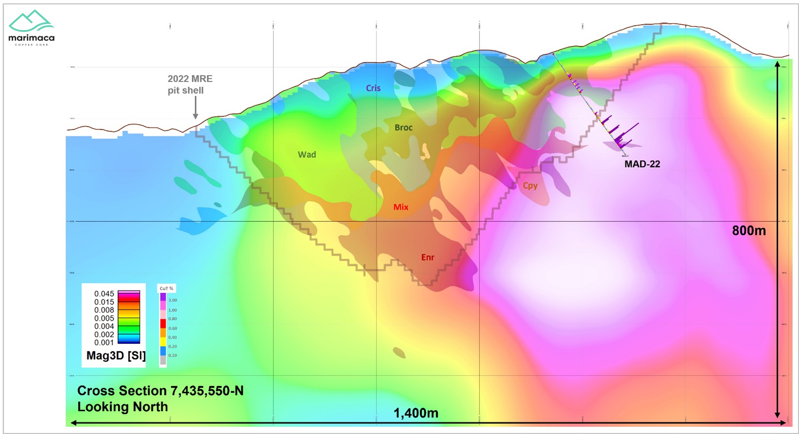
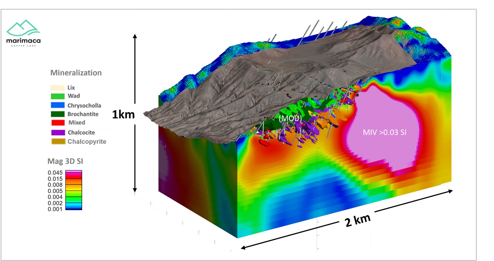
Marimaca Copper (TSX:MARI) has reported new results from diamond drill hole MAD-22 at the Marimaca Oxide deposit. The drill hole intersected high-grade primary sulphide mineralization down-dip of oxide mineralization. MAD-22 is a geological-geotechnical drill hole that the company has drilled from the easter MOD all the way through the 2022 Mineral Resource Estimate pit wall. The hole has intersected high-grade, most chalcopyrite mineralization.
MAD-22 has intersected the border of the magnetic susceptibility high identified during Marimaca’s 2020 geophysical campaign, and the magnetic anomaly under the current MOD dips to the east. It also has the same geometry as the interpreted extension of the structure hosting the copper oxide mineralization at the MOD. The drilling at MAD-22 was aimed at gathering geotechnical and geological information about the eastern pit wall area.
Sergio Rivera, VP of Exploration of Marimaca Copper, commented in a press release: “The sulphide potential at Marimaca has always presented a compelling exploration opportunity for the Company. The size of the oxide resource base at the MOD, as demonstrated in the 2022 Mineral Resource Estimate, is a testament to the scale of the mineralizing system and hole MAD-22 provides exciting evidence for potential extensions of sulphide feeder zones down-dip of Marimaca’s oxide blanket.
“While previous drilling into the down-dip geophysical targets identified in 2020 and 2021 intersected additional mixed and secondary sulphides at depth (MAMIX), MAD-22 represents the first significant primary sulphide intersection to date and could represent a primary high grade feeder structure as interpreted in our geological model for the deposit.
“With the 2022 drill program now completed, results from MAD-22 will be considered in our exploration planning going forward. We look forward to updating the market as our interpretation and plans for additional exploration work are finalized.
“In parallel and as discussed in previous releases, we will continue with our de-risking strategy at the MOD with the objective of delivering an updated MRE in early 2023, capturing the second half of the 2022 infill program. This will form the basis for the DFS on the Marimaca Oxide Deposit planned for the second half of 2023 or early 2024.”
Highlights from the results are as follows:
- Highlights from reported results are:
- Full drill hole intersection of 240m at 1.01% CuT from surface in two separate zones of oxide and primary sulphide
- Oxide highlights:
- 82m at 0.53% CuT from 10m including 50m at 0.80% CuT from 42m
- Sulphide highlights:
- 92m at 2.11% CuT from 140m, including
- 22m at 5.27% CuT from 204m
- Hole MAD-22 was drilled from inside the 2022 MRE pit area toward and through the eastern border of the MOD at depth
- Consistent with current MRE for the MOD, MAD-22 intersected oxide and mixed mineralization before transitioning into primary sulphide mineralization
- Primary mineralization is dominated by veins and stringers of massive and semi-massive chalcopyrite within dominantly magnetite-actinolite alteration consistent with magnetic highs
- The occurrence of primary sulphide mineralization down dip to the east of the MOD is consistent with the current geological model for Marimaca’s Iron-Oxide-Copper-Gold (“IOCG”)-style copper mineralization
- Mineralization at Marimaca is controlled by a regional scale system of sheeted fractures and dykes, created by a major extensional event with mineralization introduced along fractures and structural splays
- The MOD’s copper oxides were formed by the oxidation of a chalcocite enrichment blanket derived from original primary sulphides
- Results from MAD-22 will be reviewed and the Company will provide an update to the market on next steps to follow up the results in due course
- In parallel the Company will continue to progress permitting and engineering workstreams to support the planned Definitive Feasibility Study “DFS” on the Marimaca Oxide Project planned for the second half of 2023
Table 1. Summary of Drill Results
| Hole | Depth (m) | From (m) | To (m) | m | %CuT | ||
| MAD-22 | 240 | 0 | 240 | 240 | 1.01 | % | |
| including | 10 | 92 | 82 | 0.53 | % | ||
| Including | 42 | 92 | 50 | 0.80 | % | ||
| and | 112 | 232 | 120 | 1.65 | % | ||
| including | 140 | 232 | 92 | 2.11 | % | ||
| including | 178 | 232 | 54 | 2.80 | % | ||
| Including | 204 | 226 | 22 | 5.27 | % | ||
| Including | 214 | 224 | 10 | 8.10 | % | ||
Table 2. Drill Collar and Survey
| Hole | Easting | Northing | Elevation | Azimuth | Inclination | Depth |
| MAD-22 | 375143,8 | 7435536,2 | 1124,9 | 85 | -55 | 240 |
Sampling and Assay Protocol
The above references an opinion and is for information purposes only. It is not intended to be investment advice. Seek a licensed professional for investment advice. The author is not an insider or shareholder of any of the companies mentioned above.
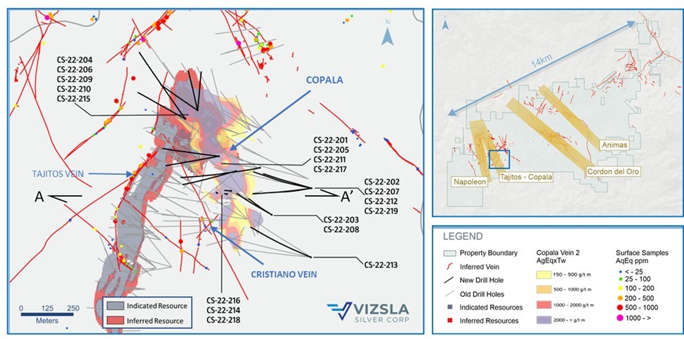
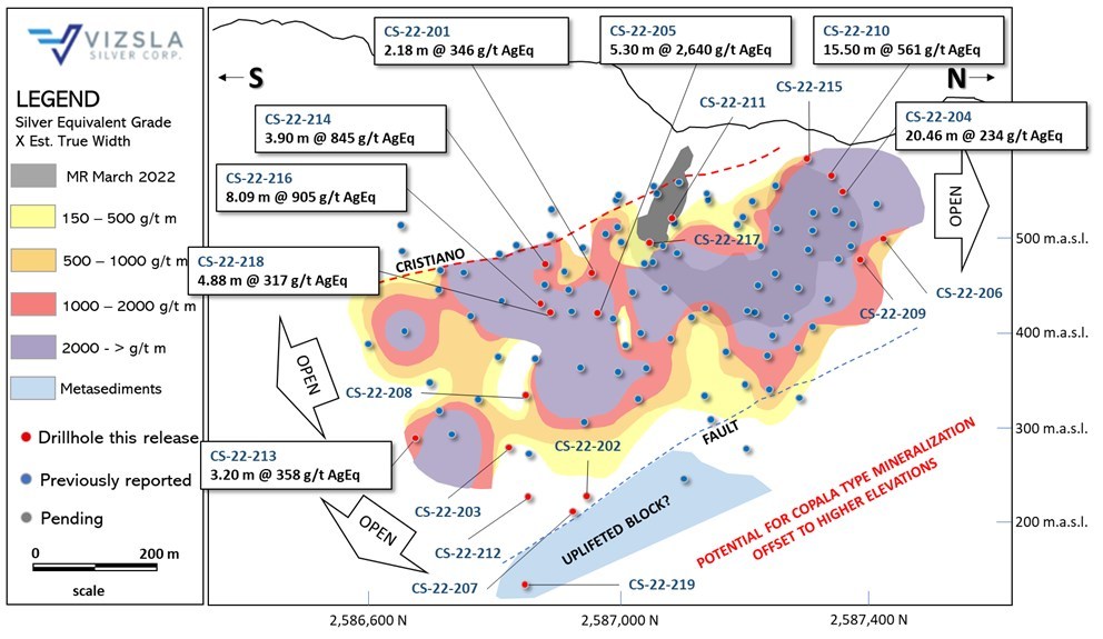
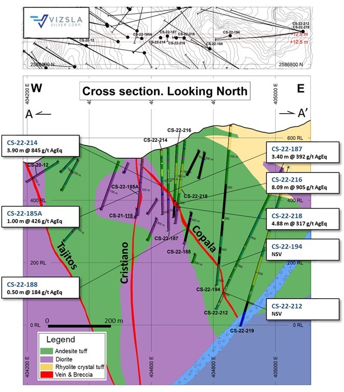
Viszla Silver (TSXV:VZLA) has reported new results from 19 new drill holes at the Tajitos – Copala resource area at the Panuco silver-gold project in Mexico. The company’s intercepts are a part of the ongoing 2022 infill-expansionary drill program at the Copala and Cristiano structures in the western section of the district.
Infill results now support grade continuity in the south-central portion of the Copala structure. Continued resource expansion drilling to the north and southeast highlights that mineralization remains open.
Michael Konnert, President and CEO commented in a press release: “The Copala structure continues to impress with high precious metals grades over very broad width. Infill drilling within the Tajitos-Copala resource area continues to highlight exceptional mineral continuity marked by multiple intervals grading well over 1,000 grams per tonne, while expansionary drilling to the north and southeast demonstrate a growing high-grade footprint. Additionally, at Cristiano, drilling has now traced mineralization over 600 metres long by 300 metres deep. We note that Cristiano was not included in the maiden resource, however, given its near surface, high-grade continuity, we expect it will contribute materially to the pending resource update. We have had a phenomenal year of exploration success at Panuco and have expanded mineralization well beyond the March 2022 resource boundary at virtually every zone. Given the amount of new high grade drill results, inclusion of new mineralized structures, and the fast-approaching holiday season, we have elected to publish the resource update in early 2023. We are extremely pleased with the outcome of our 2022 programs and look forward to another outstanding year as we continue to grow and de-risk the Panuco Project in 2023.”
Highlights from the results are as follows:
Highlights
- CS-22-205 returned 2,640 grams per tonne (g/t) silver equivalent (AgEq) over 5.30 metres true width (mTW) (2,101 g/t silver and 9.54 g/t gold)
- Including 4,563 g/t AgEq over 0.58 mTW (3,080 g/t silver and 23.60 g/t gold)
- CS-22-210 returned 561 g/t AgEq over 15.50 mTW (425 g/t silver and 2.31 g/t gold)
- And 2,044 g/t AgEq over 1.01 mTW (1,630 g/t silver and 7.34 g/t gold)
- CS-22-216 returned 905 g/t AgEq over 8.09 mTW (626 g/t silver and 4.48 g/t gold)
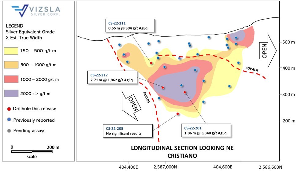
- CS-22-201 returned 3,340 g/t AgEq over 1.86 mTW (2,536 g/t silver and 13.65 g/t gold)
- CS-22-217 returned 1,862 g/t AgEq over 2.71 mTW (1,495 g/t silver and 6.56 g/t gold)
The Copala Structure is located in the western portion of the Panuco district at the northern extent of the Tajitos structure. Copala hosts high precious metals grades (up to 11,053 g/t silver and 33.50 g/t gold over 1.26 mTW) contained within a broader envelope of vein-breccia interlayered with host rock, up to 82 metres thick. Ongoing interpretations by Vizsla’s geologists suggest Copala has an average dip of ~46° to the east (~35° in its northern sector and steepening to ~52° in the southern sector).
Drilling at Copala has now traced mineralization along approximately 1,000 metres of strike length and approximately 400 metres down dip. High-grade silver-gold mineralization remains open to the north and southeast with ongoing detailed structural and geologic interpretations indicating the potential for mineralization to continue into the footwall side of the Tajitos Vein. The ongoing infill-drilling program, which consists of 25 holes drilled at 25 metre centers, was designed to assess grade continuity and to provide sample material for future metallurgical tests. To date, infill-holes CS-22-201, CS-22-205, CS-22-214, CS-22-216 and CS-22-218 have confirmed high-grade at tighter spacing. Additionally, step-out holes drilled to the east, particularly holes CS-22-202, CS-22-207 and CS-22-219, suggest an uplifted block of basement metasediments in fault-contact with andesites and diorite (see figures 2 and 4). Vizsla´s team is working on interpretations to determine the amount of displacement by the fault, to define a target elevation for Copala type mineralization on the footwall side (east) of the fault; i.e. an uplifted block on the east creates potential for Copala type mineralization at shallower elevation. Vizsla plans to test this hypothesis with drill-holes collared on the footwall side of the fault.
The Cristiano Vein is a precious metals rich structure located at the southwestern margin of the Copala structure. Cristiano is marked by a quartz-carbonate epithermal-vein striking N25°W that dips sub-vertical (85°) to the NE. Drill-holes intersecting Cristiano to date, highlight a high-grade zone plunging to the NW, with vertical extent of 300 metres and approximate strike length of 600 metres. The Cristiano Vein ranges in thickness from 0.7 mTW to 3.5 mTW, with a weighted average grade of 542 g/t silver equivalent.
The Cristiano Vein was initially discovered while targeting the Tajitos-Copala veins, where drilling intercepted the well-mineralized, NW-SE trending fault. Ongoing drilling has now led to new observations and interpretations allowing Vizsla geologists to plan drill holes specifically designed to explore Cristiano along strike and to depth. To the northwest, Cristiano intersects and offsets the Tajitos Vein, suggesting Cristiano post-dates Tajitos mineralization, thus creating a drill target on the footwall of Tajitos (Figure 3). Additionally, open ended intercepts to the southeast suggest mineralization continues in this direction.
Source: Vizsla Silver
| Drillhole | From | To | Downhole Length | Estimated True width | Ag | Au | AgEq | Vein | ||
| (m) | (m) | (m) | (m) | (g/t) | (g/t) | (g/t) | ||||
| CS-22-201 | 212.25 | 214.80 | 2.55 | 2.18 | 237 | 1.74 | 346 | Copala | ||
| Includes | 212.25 | 213.55 | 1.30 | 1.11 | 427 | 3.22 | 629 | |||
| CS-22-201 | 392.15 | 396.00 | 3.85 | 1.86 | 2,536 | 13.65 | 3,340 | Cristiano | ||
| Includes | 392.90 | 393.30 | 0.40 | 0.19 | 7,740 | 57.60 | 11,343 | |||
| Includes | 393.70 | 394.60 | 0.90 | 0.43 | 6,220 | 27.20 | 7,742 | |||
| CS-22-202 | No significant values | Copala | ||||||||
| CS-22-203 | No significant values | Copala | ||||||||
| CS-22-204 | 132.00 | 158.70 | 26.70 | 20.46 | 175 | 0.99 | 234 | Copala | ||
| Includes | 147.25 | 148.50 | 1.25 | 0.96 | 569 | 2.92 | 739 | |||
| Includes | 153.30 | 154.30 | 1.00 | 0.77 | 454 | 2.43 | 597 | |||
| Includes | 156.50 | 157.50 | 1.00 | 0.77 | 673 | 3.42 | 872 | |||
| Includes | 157.50 | 158.70 | 1.20 | 0.92 | 575 | 4.08 | 828 | |||
| CS-22-205 | 283.00 | 288.50 | 5.50 | 5.30 | 2,101 | 9.54 | 2,640 | Copala | ||
| Includes | 284.60 | 285.20 | 0.60 | 0.58 | 3,080 | 23.60 | 4,563 | |||
| CS-22-205 | 553.00 | 553.30 | 0.30 | 0.16 | 85 | 0.24 | 96 | Cristiano | ||
| CS-22-206 | 181.10 | 185.80 | 4.70 | 3.11 | 168 | 0.90 | 221 | Copala | ||
| CS-22-207 | No significant values | Copala | ||||||||
| CS-22-208 | No significant values | Copala | ||||||||
| CS-22-208 | 484.00 | 485.50 | 1.50 | 1.12 | 347 | 0.38 | 350 | FW Splay | ||
| Includes | 485.05 | 485.50 | 0.45 | 0.34 | 873 | 0.99 | 883 | |||
| CS-22-209 | 148.00 | 166.05 | 18.05 | 10.00 | 74 | 0.56 | 109 | Copala | ||
| Includes | 163.45 | 164.20 | 0.75 | 0.42 | 639 | 5.22 | 970 | |||
| CS-22-210 | 117.75 | 140.70 | 22.95 | 15.50 | 425 | 2.31 | 561 | Copala | ||
| Includes | 120.30 | 120.90 | 0.60 | 0.41 | 2,710 | 22.30 | 4,125 | |||
| Includes | 130.60 | 131.40 | 0.80 | 0.54 | 1,285 | 7.24 | 1,716 | |||
| Includes | 131.40 | 132.00 | 0.60 | 0.41 | 1,800 | 9.69 | 2,371 | |||
| Includes | 132.55 | 134.05 | 1.50 | 1.01 | 1,630 | 7.34 | 2,044 | |||
| CS-22-211 | No significant values | Copala | ||||||||
| CS-22-211 | 240.00 | 241.85 | 1.85 | 0.55 | 154 | 2.24 | 304 | Cristiano | ||
| CS-22-211 | 283.25 | 284.50 | 1.25 | 1.25 | 1,103 | 3.76 | 1,296 | Tajitos | ||
| CS-22-212 | No significant values | Copala | ||||||||
| CS-22-213 | 545.10 | 548.60 | 3.50 | 3.20 | 294 | 1.19 | 358 | Copala | ||
| Includes | 546.50 | 547.95 | 1.45 | 1.33 | 308 | 2.08 | 436 | |||
| CS-22-214 | 114.00 | 121.05 | 7.05 | 3.90 | 593 | 4.07 | 845 | Copala | ||
| Includes | 115.50 | 116.80 | 1.30 | 0.72 | 2,020 | 13.50 | 2,850 | |||
| Includes | 116.80 | 117.50 | 0.70 | 0.39 | 681 | 4.22 | 937 | |||
| CS-22-215 | 112.50 | 115.50 | 3.00 | 2.35 | 216 | 0.66 | 248 | Copala | ||
| Includes | 114.00 | 115.50 | 1.50 | 1.18 | 335 | 1.03 | 385 | |||
| CS-22-216 | 181.00 | 194.50 | 13.50 | 8.09 | 626 | 4.48 | 905 | Copala | ||
| Includes | 184.65 | 186.00 | 1.35 | 0.81 | 1,250 | 14.00 | 2,170 | |||
| Includes | 186.00 | 186.95 | 0.95 | 0.57 | 2,230 | 18.10 | 3,376 | |||
| Includes | 186.95 | 188.20 | 1.25 | 0.75 | 1,170 | 7.54 | 1,631 | |||
| CS-22-217 | No significant values | Copala | ||||||||
| CS-22-217 | 325.50 | 330.35 | 4.85 | 2.71 | 1,495 | 6.56 | 1,862 | Cristiano | ||
| Includes | 327.60 | 328.75 | 1.15 | 0.64 | 1,295 | 4.59 | 1,535 | |||
| Includes | 328.75 | 329.10 | 0.35 | 0.20 | 13,118 | 63.70 | 16,783 | |||
| CS-22-218 | 209.60 | 215.30 | 5.70 | 4.88 | 197 | 1.86 | 317 | Copala | ||
| Includes | 211.50 | 213.00 | 1.50 | 1.28 | 283 | 3.19 | 493 | |||
| Includes | 213.00 | 214.15 | 1.15 | 0.98 | 280 | 2.58 | 446 | |||
| CS-22-219 | No intercepted | |||||||||
Table 1: Downhole drill intersections from the holes reported for the new splay vein at the foot wall of Copala. Note: AgEq = Ag g/t x Ag rec. + (Au g/t x Au Rec x Au price/gram)/Ag price/gram. Metal price assumptions are $20.70/oz silver and $1,655/oz gold and metallurgical recoveries assumed are 93% for silver and 90% for gold. Gold and silver metallurgical recoveries used in this release are from metallurgical test results of the Napoleon vein (see press release dated February 17, 2022).
| Drillhole | Easting | Northing | Elevation | Azimuth | Dip | Depth |
| CS-22-201 | 404,724 | 2,586,986 | 595 | 257 | -57.7 | 462.0 |
| CS-22-202 | 405,087 | 2,586,905 | 646 | 282 | -63.6 | 634.5 |
| CS-22-203 | 404,896 | 2,586,778 | 666 | 302 | -75.0 | 556.5 |
| CS-22-204 | 404,539 | 2,587,280 | 553 | 304 | -30.8 | 250.2 |
| CS-22-205 | 404,840 | 2,587,003 | 590 | 260 | -50.0 | 596.5 |
| CS-22-206 | 404,541 | 2,587,280 | 552 | 347 | -35.0 | 237.0 |
| CS-22-207 | 405,087 | 2,586,905 | 646 | 286 | -68.2 | 628.0 |
| CS-22-208 | 404,896 | 2,586,778 | 666 | 299 | -67.9 | 505.5 |
| CS-22-209 | 404,541 | 2,587,280 | 553 | 5 | -43.3 | 257.0 |
| CS-22-210 | 404,482 | 2,587,238 | 553 | 323 | -30.0 | 451.0 |
| CS-22-211 | 404,643 | 2,587,058 | 557 | 277 | -39.5 | 349.5 |
| CS-22-212 | 405,087 | 2,586,905 | 646 | 263 | -64.9 | 658.5 |
| CS-22-213 | 405,084 | 2,586,574 | 700 | 295 | -58.8 | 637.5 |
| CS-22-214 | 404,632 | 2,586,883 | 568 | 91 | -89.1 | 208.5 |
| CS-22-215 | 404,482 | 2,587,237 | 553 | 298 | -30.0 | 300.0 |
| CS-22-216 | 404,681 | 2,586,877 | 582 | 271 | -87.0 | 234.0 |
| CS-22-217 | 404,643 | 2,587,058 | 557 | 260 | -54.0 | 452.0 |
| CS-22-218 | 404,701 | 2,586,892 | 595 | 271 | -84.6 | 270.0 |
| CS-22-219 | 405,087 | 2,586,905 | 565 | 262 | -71.4 | 681.0 |
Table 2: Drillhole details for the reported drillholes. Coordinates in WGS84, Zone 13.
The above references an opinion and is for information purposes only. It is not intended to be investment advice. Seek a licensed professional for investment advice. The author is not an insider or shareholder of any of the companies mentioned above.
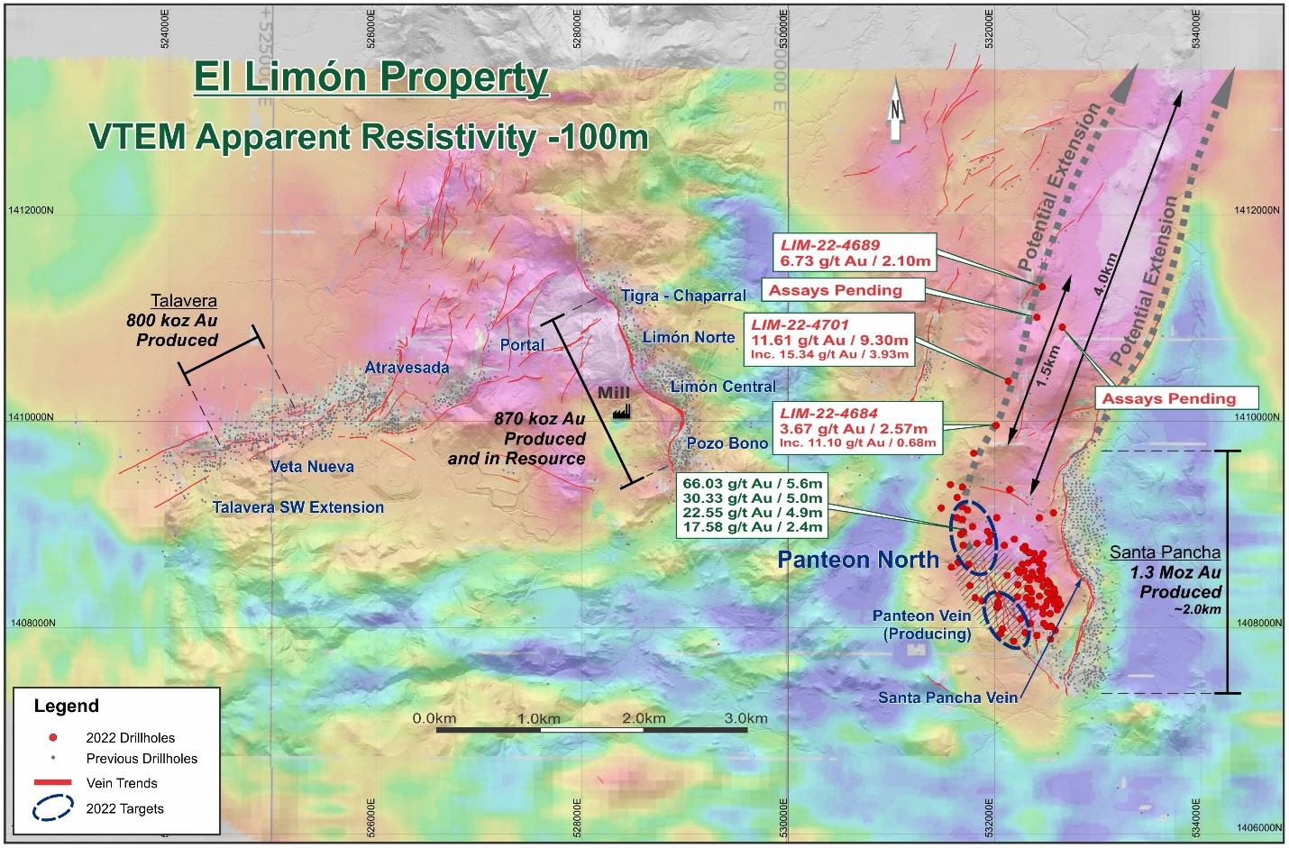
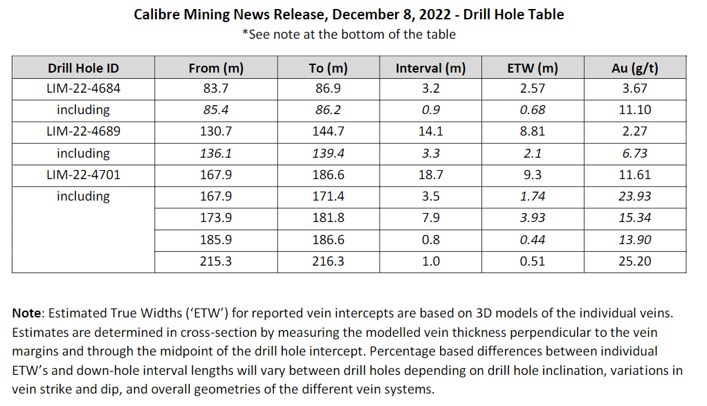
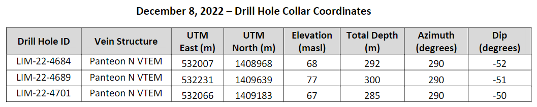
Calibre Mining (TSX:CXB) has announced the very first results from step-out drilling along the Panteon North/VTEM geophysical corridor at the Limon Mine Complex. The drilling was designed to test a multi-kilometre structure identified in the 2022 VTEM geophysical survey, with results returning new intercepts. The results come from roughly 2.5 kilometres north of Panteon North, which the company has previously reported multiple high-grade gold intercepts to this point. The company expects the Panteon North corridor to continue to contribute to its 2022 Resource and Reserve statement that it expects to release in Q1 2023.
Darren Hall, President and Chief Executive Officer of Calibre, commented in a press release: “Our 2022 drilling campaign has been very successful, with the discovery of the high-grade Panteon North gold shoot which hosts numerous bonanza grade gold intercepts over hundreds of metres of strike length. First pass, wide spaced drilling approximately 2.5 kilometres north of Panteon North along the VTEM geophysical corridor has now discovered another new high-grade gold zone which stretches over an initial 1.5-kilometre trend (see figures). The VTEM survey, first released on June 27, 2022 (see news release here) has proven to be an excellent tool for targeting zones of high-grade gold mineralization along multiple kilometers of strike from Panteon North. Discovery drilling is underway with four diamond drill rigs along the corridor.”
Highlights from the results are as follows:
- 11.61 g/t Au over 9.3 metres Estimated True Width (“ETW”) including 23.93 g/t Au over 1.7 metres ETW, and 15.34 g/t Au over 3.9 metres ETW in Hole LIM-22-4701;
- 6.73 g/t Au over 2.1 metres ETW in Hole LIM-22-4689;
- 3.67 g/t Au over 2.6 metres ETW including 11.10 g/t Au over 0.7 metres ETW in Hole LIM-22-4684.
The above references an opinion and is for information purposes only. It is not intended to be investment advice. Seek a licensed professional for investment advice. The author is not an insider or shareholder of any of the companies mentioned above.
Ascot Resources (TSX:AOT) has announced that recent assay results showed the highest grade intercept since 2017 of 488 g/t Gold Over 1.0 metre at the Big Missouri Deposit. This is the third batch of assay results at the deposit as part of the 2022 drill program at the Premier Gold Project. Results come from surface drilling for in-fill and exploration purposes at the site. Big Missouri is located roughly six kilometres north of the Premier mill, a past-producing mill in the Golden Triangle of northwestern British Columbia.
Derek White, President and CEO of Ascot Resources, commented in a press release: “The Big Missouri deposit continues to impress with more bonanza-grade gold and additional occurrences of coarse, visible gold. The headline intercept of 488 grams per tonne is the highest-grade interval Ascot has drilled since 2017, and the fourth-highest assay ever recorded at Big Missouri. The drill holes from this release contain 20 assays over 10 grams per tonne gold. Many of the high-grade intercepts were encountered within or around existing stope shapes, and some high grades were encountered in gaps between stope shapes – further strengthening our confidence that there is more gold to be discovered outside the existing resource model at Big Missouri.”
Highlights from the results are as follows:
- 62.76 g/t Au and 27.36 g/t Ag over 7.90m from a depth of 90.00m in hole P22-2445, including 488.00 g/t Au and 181.00 g/t Ag over 1.00m
- 30.98 g/t Au and 9.35 g/t Ag over 3.00m from a depth of 112.00m in hole P22-2445, including 90.70 g/t Au and 19.75 g/t Ag over 1.00m
- 6.75 g/t Au and 12.44 g/t Ag over 14.5m from a depth of 26.00m in hole P22-2444, including 26.00 g/t Au and 28.30 g/t Ag over 1.43m and 28.80 g/t Au and 30.20 g/t Ag over 1.00m
- 8.03 g/t Au and 19.13 g/t Ag over 9.52m from a depth of 23.38m in hole P22-2441, including 44.50 g/t Au and 109.00 g/t Ag over 1.00m
- 6.26 g/t Au and 8.13 g/t Ag over 10.80m from a depth of 29.40m in hole P22-2442, including 43.60 g/t Au and 30.10 g/t Ag over 1.00m
Note: True widths are estimated to be between 60% to 80% of reported interval widths.
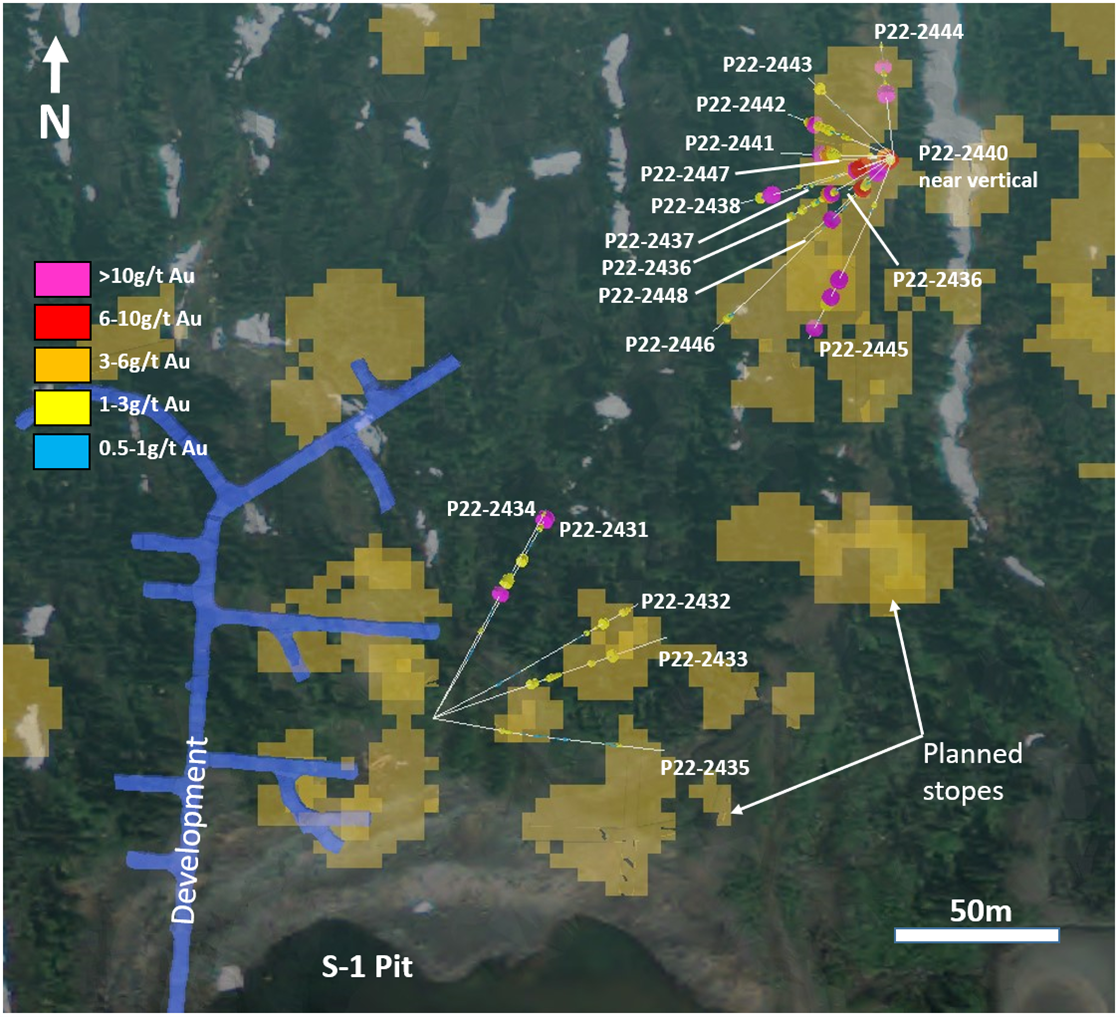
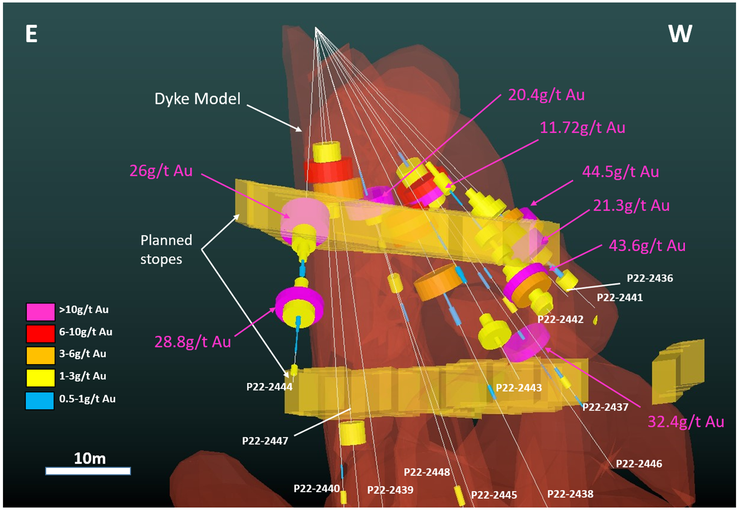
Drilling for the 2022 exploration season at the Big Missouri deposit was completed in October, totaling 50 holes and 4,752 metres. Following the first two batches of 28 drill holes outlined in the news releases dated September 13 and October 27, 2022, this release summarizes the third batch of assay results from the next 18 drill holes for a total of 1,798 metres from surface pads BM–2/22 and BM–3/22. Drill holes were targeting several layers of gold mineralization at the A Zone and the Unicorn Area of the Big Missouri deposit in and around planned stopes to the north and northeast of the S-1 pit.
As summary of drill assays is shown in Table 1. An overview of drill hole locations is shown in Figure 1 and a cross section is shown in Figure 2. This release contains the assay results from the last 5 holes drilled from pad BM–2/22 and all 13 holes drilled from pad BM–3/22, approximately 200 metres to the northeast.
The results are headlined by hole P22-2445 which intercepted 488.00 g/t Au and 181.00 g/t Ag over 1.00m, within a broader interval of 62.76 g/t Au and 27.36 g/t Ag over 7.90m, starting from a depth of 90.00m. This is the highest-grade interval Ascot has drilled since 2017, and the fourth-highest assay ever recorded at Big Missouri. This intercept along with an interval of 12.30 g/t Au in hole P22-2438 occurs within a group of lower grade intercepts that had previously not been wireframed and will now constitute a new zone of mineralization. Similarly, holes P22-2431 and P22-2434 intercepted high-grade gold in a large gap area between stope shapes, indicating potential to add more mineralization as mining progresses.
Figure 2 shows where the new drill holes intercepted high-grade gold within and near planned stope shapes, reinforcing the current wireframe geometry. This is showcased by the 44.50 g/t Au intercept in hole P22-2441, the 26.00 g/t Au intercept in hole P22-2444, and the 21.30 g/t Au intercept in hole P22-2436.
The remaining outstanding assay results from the 2022 exploration drill season consist of 12 holes drilled from underground at Big Missouri, 4 surface in-fill holes near the S1 pit at Big Missouri, and 12 holes drilled from two surface pads at the Day Zone on the western side of the Big Missouri ridge. The Company anticipates the receipt of all outstanding assays in early 2023.
Table 1 – Big Missouri drill results
| Hole # | Azimuth
/dip |
From
(m) |
To
(m) |
Width
(m) |
Au
(g/t) |
Ag
(g/t) |
| P22-2431 | 30/-49 | 84.00 | 86.00 | 2.00 | 3.34 | 8.90 |
| and | 105.12 | 109.72 | 4.60 | 5.84 | 5.59 | |
| P22-2432 | 61/-49 | 91.00 | 92.00 | 1.00 | 3.35 | 7.90 |
| and | 101.51 | 103.00 | 1.49 | 2.29 | 5.10 | |
| P22-2433 | 71/-46 | 45.00 | 48.00 | 3.00 | 2.46 | 10.43 |
| and | 53.87 | 59.00 | 5.13 | 1.83 | 5.41 | |
| and | 73.16 | 75.36 | 2.20 | 1.59 | 4.00 | |
| and | 83.00 | 84.00 | 1.00 | 3.72 | 4.40 | |
| P22-2434 | 28/-35 | 36.50 | 38.10 | 1.60 | 1.21 | 6.10 |
| and | 52.00 | 53.50 | 1.50 | 10.07 | 6.35 | |
| and | 56.83 | 61.00 | 4.17 | 2.83 | 5.30 | |
| and | 86.19 | 87.50 | 1.31 | 1.14 | 2.80 | |
| P22-2435 | 98/-50 | 32.50 | 37.13 | 4.63 | 1.40 | 5.15 |
| and | 88.00 | 90.00 | 2.00 | 1.09 | 2.30 | |
| P22-2436 | 240/-44 | 29.00 | 33.50 | 4.50 | 8.62 | 11.33 |
| incl. | 30.19 | 31.50 | 1.31 | 21.30 | 17.60 | |
| and | 44.00 | 45.50 | 1.50 | 2.68 | 4.00 | |
| and | 49.50 | 50.90 | 1.40 | 2.48 | 3.40 | |
| P22-2437 | 250/-55 | 19.65 | 21.70 | 2.05 | 11.72 | 12.91 |
| and | 34.65 | 36.45 | 1.80 | 1.11 | 3.90 | |
| and | 44.95 | 46.15 | 1.20 | 1.15 | 9.30 | |
| P22-2438 | 253/-64 | 21.07 | 24.37 | 3.30 | 6.11 | 17.97 |
| and | 28.60 | 30.60 | 2.00 | 4.86 | 5.10 | |
| and | 68.35 | 70.35 | 2.00 | 1.24 | 8.60 | |
| and | 88.35 | 90.35 | 2.00 | 12.30 | 10.60 | |
| and | 96.52 | 97.92 | 1.40 | 3.20 | 19.60 | |
| P22-2439 | 274/-82 | 16.21 | 18.26 | 2.05 | 5.56 | 5.40 |
| P22-2440 | 274/-88 | 12.70 | 14.67 | 1.97 | 1.68 | 5.90 |
| and | 163.73 | 165.73 | 2.00 | 2.09 | 2.10 | |
| P22-2441 | 272/-45 | 23.38 | 32.90 | 9.52 | 8.03 | 19.13 |
| incl. | 31.90 | 32.90 | 1.00 | 44.50 | 109.00 | |
| P22-2442 | 292/-45 | 29.40 | 40.20 | 10.80 | 6.26 | 8.13 |
| incl. | 36.00 | 37.00 | 1.00 | 43.60 | 30.10 | |
| P22-2443 | 313/-45 | 40.90 | 44.85 | 3.95 | 1.68 | 3.01 |
| P22-2444 | 354/-45 | 26.00 | 40.50 | 14.50 | 6.75 | 12.44 |
| incl. | 26.00 | 27.43 | 1.43 | 26.00 | 28.30 | |
| and | 38.50 | 39.50 | 1.00 | 28.80 | 30.20 | |
| and | 47.50 | 48.50 | 1.00 | 1.08 | 3.80 | |
| P22-2445 | 205/-60 | 30.81 | 32.43 | 1.62 | 1.61 | 3.70 |
| and | 80.00 | 83.58 | 3.58 | 8.34 | 2.83 | |
| incl. | 80.00 | 82.00 | 2.00 | 13.55 | 3.80 | |
| and | 90.00 | 97.90 | 7.90 | 62.76 | 27.36 | |
| incl. | 92.00 | 93.00 | 1.00 | 488.00 | 181.00 | |
| and | 112.00 | 115.00 | 3.00 | 30.98 | 9.35 | |
| incl. | 113.00 | 114.00 | 1.00 | 90.70 | 19.75 | |
| P22-2446 | 226/-50 | 19.00 | 24.19 | 5.19 | 4.77 | 13.72 |
| and | 42.60 | 43.71 | 1.11 | 32.40 | 17.60 | |
| and | 110.50 | 112.70 | 2.20 | 2.32 | 4.50 | |
| P22-2447 | 233/-84 | 12.25 | 20.00 | 7.75 | 3.25 | 4.78 |
| incl. | 14.00 | 16.00 | 2.00 | 7.41 | 6.60 | |
| and | 41.54 | 43.70 | 2.16 | 2.89 | 2.00 | |
| P22-2448 | 228/-70 | 18.87 | 24.85 | 5.98 | 6.32 | 34.44 |
| incl. | 18.87 | 19.69 | 0.82 | 20.40 | 192.00 | |
| and | 51.50 | 53.50 | 2.00 | 1.05 | 2.70 |
Note: True widths are estimated to be between 60% to 80% of reported interval widths.
Table 2 – Drill pad locations
| Pad # | UTM N | UTM E | Elevation (masl) | Hole no. |
| BM-2/22 | 436530 | 6219505 | 997.3 | P22-2431 to P22-2435 |
| BM-3/22 | 436671 | 6219676 | 997.5 | P22-2436 to P22-2448 |
The Big Missouri deposit hosts a probable reserve of 809 kt grading 7.15 g/t Au and 12.2 g/t Ag and containing 186 koz Au and 317 koz Ag, an indicated resource of 1,116 kt grading 8.36 g/t Au and 16.9 g/t Ag and containing 300 koz Au and 607 koz Ag, and an inferred resource of 1,897 kt grading 8.34 g/t Au and 14.7 g/t Ag and containing 508 koz Au and 896 koz Ag. These reserves and resources are outlined in the NI 43-101 technical report entitled “Premier & Red Mountain Gold Project Feasibility Study NI 43-101 Technical Report, British Columbia”, dated May 22, 2020, with an effective date of April 15, 2020.
The above references an opinion and is for information purposes only. It is not intended to be investment advice. Seek a licensed professional for investment advice. The author is not an insider or shareholder of any of the companies mentioned above.
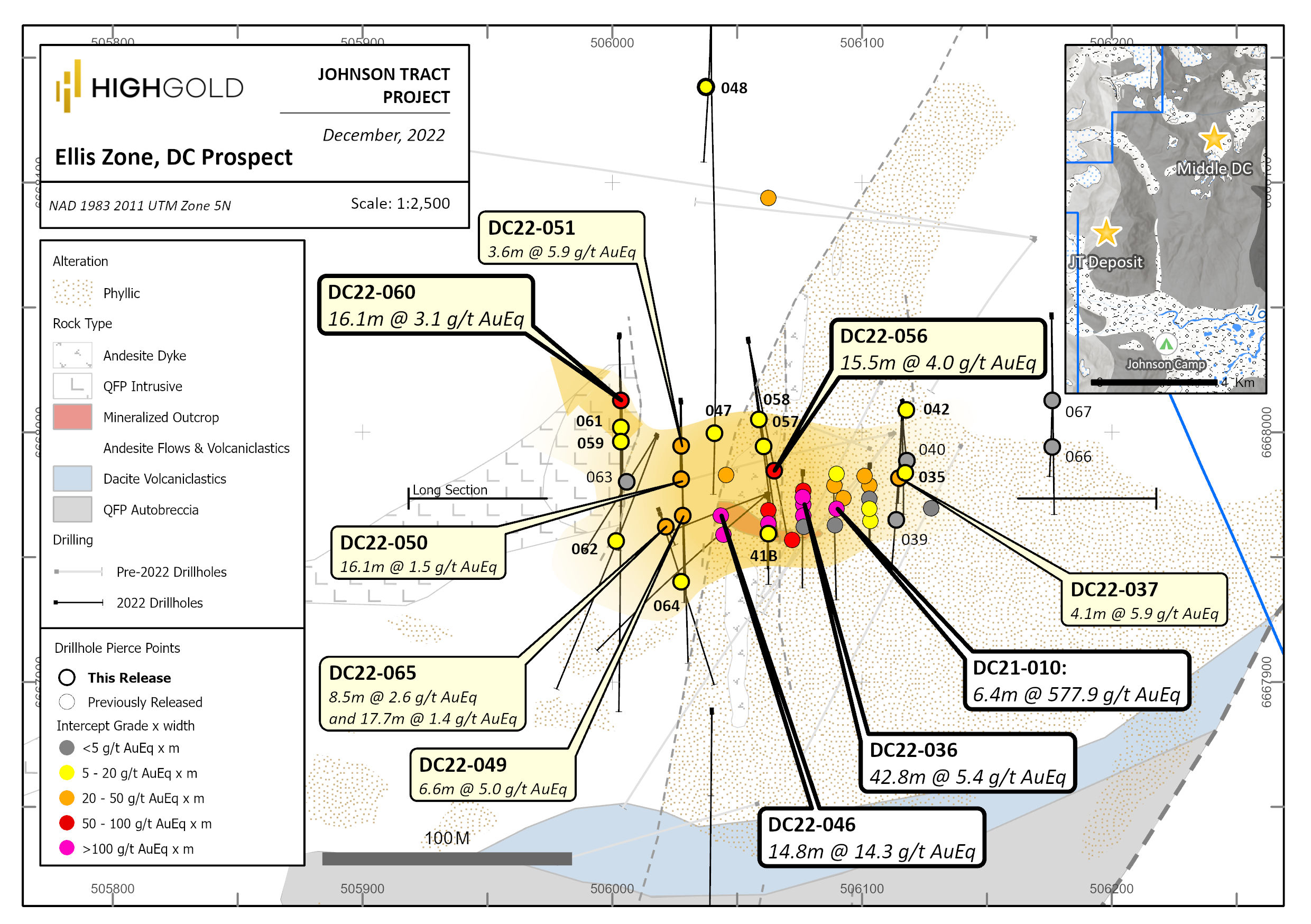
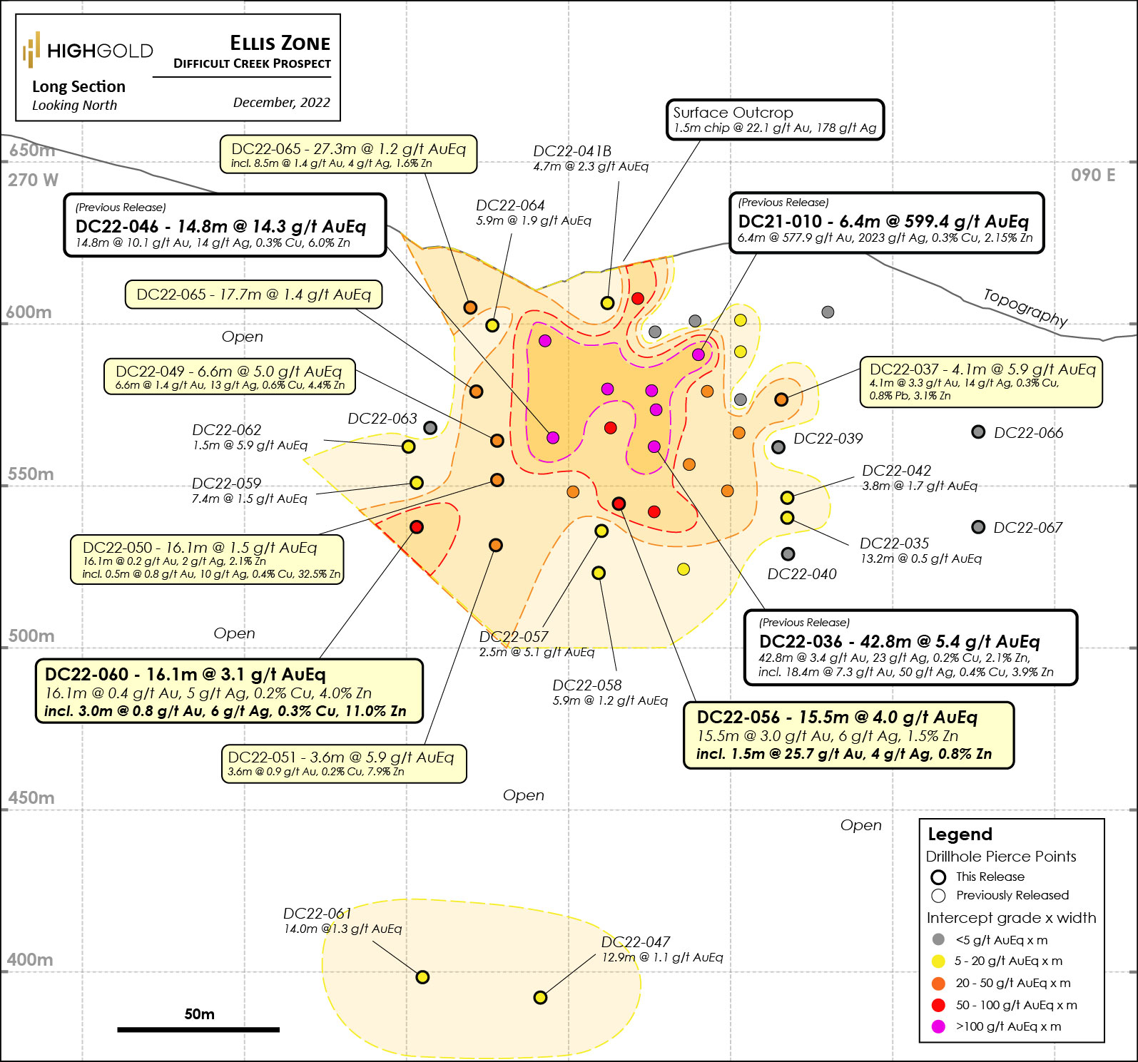
HighGold Mining (TSXV:HIGH) has reported new assay results from 2022 drilling at the Ellis Zone discovery at the Difficult Creek Prospect. These are the third and final batch of results from the project, which is located four kilometres northeast of the 1.005 Moz indicated at 9.4 g/t gold equivalent JT Deposit. This is one of many district-scale prospects HighGold Mining is exploring in Southcentral Alaska on the Johnson Tract project.
The diamond drilling completed during the second half of the 2022 summer field season was focused on systematically stepping out along strike and at depth on the Ellis Zone on 25 to 50-meter centres. The new drilling has returned strong mineralization west and down-plunge of recently released results and includes 15.5m at 4.04 g/t AuEq, including 1.5m at 26.24 g/t AuEq, in hole DC22-056, and 16.1m at 3.07 g/t AuEq, including 3.0m at 7.84 g/t AuEq, in hole DC22-060.
Darwin Green, CEO of HighGold Mining, commented in a press release: “The 2022 drill program at the Ellis Zone was very successful in sketching-in a new center of high-grade gold and base metal mineralization with similar characteristics to the main +1Moz JT Deposit located 4km away. This is strong validation of the district potential for multiple deposits and the opportunity to contribute additional mineral resources to the existing resource base. To date, the Ellis Zone has been documented over a strike length of 125 meters and from surface to a depth of 225 meters and is open to expansion. It remains early days in the exploration of this promising new zone, and we look forward to returning in 2023 with larger step-outs, particularly down plunge to the west and to depth.”
Highlights from the results are as follows:
- 4.1m at 5.89 g/t AuEq (3.28 g/t Au, 3.14% Zn, 0.81% Pb, 0.29% Cu), in hole DC22-037, including
- 0.9m at 16.21 g/t AuEq (14.55 g/t Au, 0.22% Zn, 0.89% Cu)
- 6.6m at 4.96 g/t AuEq (1.43 g/t Au, 4.35% Zn, 0.62% Cu), in hole DC22-049, including
- 1.3m at 12.90 g/t AuEq (5.70 g/t Au, 2.08% Zn, 2.55% Cu)
- 16.1m at 1.53 g/t AuEq (0.17 g/t Au, 2.08% Zn), in hole DC22-050, including
- 0.5m at 20.59 g/t AuEq (0.76 g/t Au, 32.50% Zn, 0.43%)
- 3.6m at 5.92 g/t AuEq (0.90 g/t Au, 7.91% Zn), in hole DC22-051, including
- 1.5m at 9.83 g/t AuEq (1.91 g/t Au, 12.75% Zn, 0.29% Cu)
- 15.5m at 4.04 g/t AuEq (2.99 g/t Au, 1.49% Zn), in hole DC22-056, including
- 1.5m at 26.24 g/t AuEq (25.70 g/t Au, 0.81% Zn)
- 16.1m at 3.07 g/t AuEq (0.36 g/t Au, 3.97% Zn, 0.21% Cu), in hole DC22-060, including
- 3.0m at 7.84 g/t AuEq (0.75 g/t Au, 11.03% Zn, 0.31% Cu)
- 8.5m at 2.62 g/t AuEq (1.41 g/t Au, 1.55% Zn, 0.69% Pb), in hole DC22-065
Table 1. Significant Assay Intersections from the Ellis Zone, Johnson Tract Project
| Drill Hole | From | To | Length | Au | Ag | Cu | Pb | Zn | AuEq |
| (meters) | (meters) | (meters) | (g/t) | (g/t) | % | % | % | (g/t) | |
| DC22-035 | 79.6 | 92.8 | 13.2 | 0.12 | 2.9 | 0.03 | 0.17 | 0.45 | 0.5 |
| DC22-036* | 41.0 | 83.8 | 42.8 | 3.44 | 23.3 | 0.21 | 0.83 | 2.06 | 5.4 |
| Incl | 42.0 | 60.4 | 18.4 | 7.29 | 49.9 | 0.44 | 1.78 | 3.92 | 11.2 |
| Incl | 47.0 | 50.7 | 3.7 | 18.00 | 86.8 | 0.91 | 1.62 | 4.05 | 22.9 |
| DC22-037 | 57.4 | 61.5 | 4.1 | 3.28 | 14.1 | 0.29 | 0.81 | 3.14 | 5.9 |
| Incl | 58.4 | 59.3 | 0.9 | 14.55 | 35.7 | 0.89 | 0.15 | 0.22 | 16.2 |
| DC22-038* | 74.6 | 82.8 | 8.2 | 4.39 | 8.7 | 0.34 | 0.03 | 0.28 | 5.1 |
| Incl | 74.6 | 80.1 | 5.5 | 5.95 | 11.9 | 0.50 | 0.01 | 0.21 | 6.8 |
| DC22-039 | NSV | ||||||||
| DC22-040 | NSV | ||||||||
| DC22-041 | 17.9 | 19.9 | 2.00 | 0.37 | 8.9 | 0.38 | 2.30 | 4.52 | 4.3 |
| And | 32.2 | 38.2 | 6.0 | 1.13 | 7.1 | 0.09 | 0.72 | 1.30 | 2.3 |
| Incl | 32.2 | 35.2 | 3.0 | 1.84 | 11.6 | 0.12 | 1.14 | 1.85 | 3.6 |
| DC22-041B | 1.4 | 3.2 | 1.8 | 1.81 | 17.2 | 0.06 | 0.06 | 0.05 | 2.1 |
| And | 17.4 | 22.1 | 4.7 | 0.13 | 7.1 | 0.26 | 1.36 | 2.35 | 2.3 |
| Incl | 20.1 | 21.1 | 1.0 | 0.36 | 15.4 | 0.72 | 2.94 | 5.36 | 5.5 |
| DC22-042 | 80.7 | 84.5 | 3.8 | 0.55 | 83.5 | 0.02 | 0.18 | 0.42 | 1.7 |
| DC22-043* | 37.1 | 49.0 | 11.9 | 21.68 | 30.1 | 0.61 | 0.38 | 4.20 | 25.3 |
| Incl | 37.1 | 43.7 | 6.6 | 38.31 | 48.8 | 0.89 | 0.37 | 5.48 | 43.3 |
| Incl | 37.1 | 41.0 | 3.9 | 54.20 | 71.1 | 1.26 | 0.48 | 8.29 | 61.6 |
| DC22-044* | 46.4 | 66.7 | 20.3 | 1.72 | 5.6 | 0.14 | 0.18 | 1.46 | 2.9 |
| Incl | 52.8 | 54.8 | 2.0 | 8.34 | 8.9 | 0.41 | 0.44 | 4.00 | 11.4 |
| DC22-045* | 4.6 | 57.1 | 52.5 | 2.95 | 5.5 | 0.10 | 1.01 | 2.38 | 4.9 |
| Incl | 9.1 | 44.3 | 35.2 | 4.20 | 6.1 | 0.12 | 1.40 | 3.19 | 6.7 |
| Incl | 9.1 | 11.0 | 1.9 | 12.95 | 37.7 | 0.08 | 13.51 | 31.42 | 36.2 |
| Incl | 30.0 | 43.3 | 13.3 | 7.81 | 6.4 | 0.23 | 1.31 | 2.35 | 10.0 |
| DC22-046* | 56.0 | 70.8 | 14.8 | 10.14 | 13.8 | 0.28 | 0.46 | 5.97 | 14.3 |
| Incl | 56.0 | 65.7 | 9.7 | 15.34 | 20.0 | 0.42 | 0.60 | 8.58 | 21.3 |
| Incl | 57.5 | 64.3 | 6.8 | 21.29 | 25.1 | 0.55 | 0.61 | 10.70 | 28.7 |
| Incl | 57.5 | 59.0 | 1.5 | 62.50 | 10.5 | 0.77 | 0.59 | 10.50 | 70.0 |
| DC22-047 | 97.8 | 159.1 | 61.3 | 0.19 | 0.4 | 0.05 | 0.06 | 1.02 | 0.9 |
| Incl | 145.5 | 149.3 | 3.8 | 0.51 | 2.1 | 0.38 | 0.01 | 5.42 | 4.2 |
| And | 264.0 | 276.9 | 12.9 | 0.08 | 3.1 | 0.73 | 0.01 | 0.11 | 1.1 |
| Incl | 274.7 | 276.2 | 1.5 | 0.20 | 5.7 | 2.66 | 0.01 | 0.07 | 3.7 |
| DC22-048 | 80.2 | 88.6 | 8.4 | 0.20 | 2.3 | 0.21 | 0.20 | 1.27 | 1.3 |
| Incl | 84.5 | 85.7 | 1.2 | 0.51 | 7.9 | 1.03 | 0.91 | 3.21 | 4.1 |
| And | 129.0 | 137.4 | 8.4 | 0.10 | 4.4 | 0.35 | 0.03 | 2.08 | 1.8 |
| Incl | 129.0 | 131.4 | 2.4 | 0.25 | 12.7 | 1.20 | 0.04 | 4.87 | 4.8 |
| DC22-049 | 55.7 | 62.3 | 6.6 | 1.43 | 13.4 | 0.62 | 0.13 | 4.35 | 5.0 |
| Incl | 59.6 | 60.9 | 1.3 | 5.70 | 54.9 | 2.55 | 0.19 | 5.68 | 12.9 |
| And | 72.9 | 76.2 | 3.3 | 0.39 | 4.9 | 0.23 | 0.09 | 3.29 | 2.7 |
Table 1 Continued.
| Drill Hole | From | To | Length | Au | Ag | Cu | Pb | Zn | AuEq |
| (meters) | (meters) | (meters) | (g/t) | (g/t) | % | % | % | (g/t) | |
| DC22-050 | 52.8 | 68.9 | 16.1 | 0.17 | 2.3 | 0.05 | 0.16 | 2.08 | 1.5 |
| Incl | 62.9 | 63.4 | 0.5 | 0.76 | 9.9 | 0.43 | 0.03 | 32.50 | 20.6 |
| DC22-051 | 76.4 | 80.0 | 3.6 | 0.90 | 3.1 | 0.21 | 0.17 | 7.91 | 5.9 |
| Incl | 77.6 | 79.1 | 1.5 | 1.91 | 3.3 | 0.29 | 0.33 | 12.75 | 9.9 |
| DC22-052** | NSV | ||||||||
| DC22-053** | 27.5 | 29.2 | 1.7 | 0.47 | 9.4 | 0.18 | 0.65 | 2.30 | 2.4 |
| DC22-054** | NSV | ||||||||
| DC22-055** | NSV | ||||||||
| DC22-056 | 71.3 | 86.8 | 15.5 | 2.99 | 6.4 | 0.06 | 0.12 | 1.49 | 4.0 |
| Incl | 79.8 | 81.3 | 1.5 | 25.70 | 3.5 | 0.01 | 0.03 | 0.81 | 26.2 |
| DC22-057 | 72.9 | 75.4 | 2.5 | 0.74 | 2.9 | 0.11 | 0.05 | 7.10 | 5.1 |
| Incl | 72.9 | 74.4 | 1.5 | 1.01 | 3.7 | 0.12 | 0.06 | 10.25 | 7.3 |
| DC22-058 | 29.2 | 30.7 | 1.5 | 0.04 | 296.0 | 0.05 | 0.58 | 1.30 | 4.0 |
| And | 62.6 | 68.6 | 6.0 | 0.49 | 1.8 | 0.02 | 0.12 | 0.63 | 0.9 |
| And | 79.1 | 85.0 | 5.9 | 0.82 | 0.9 | 0.00 | 0.15 | 0.61 | 1.2 |
| DC22-059 | 57.9 | 65.3 | 7.4 | 0.41 | 1.8 | 0.03 | 0.14 | 1.69 | 1.5 |
| Incl | 61.1 | 64.3 | 3.2 | 0.55 | 1.5 | 0.04 | 0.18 | 2.67 | 2.3 |
| DC22-060 | 53.1 | 69.2 | 16.1 | 0.36 | 4.7 | 0.21 | 0.19 | 3.97 | 3.1 |
| Incl | 57.8 | 60.8 | 3.0 | 0.75 | 6.4 | 0.31 | 0.42 | 11.03 | 7.8 |
| DC22-061 | 198.0 | 212.0 | 14.0 | 0.15 | 3.0 | 0.62 | 0.00 | 0.46 | 1.3 |
| Incl | 199.5 | 201.9 | 2.4 | 0.50 | 9.6 | 1.67 | 0.00 | 0.76 | 3.2 |
| DC22-062 | 44.1 | 49.1 | 5.0 | 0.24 | 3.6 | 0.03 | 0.24 | 1.08 | 1.0 |
| And | 67.3 | 68.8 | 1.5 | 5.82 | 1.4 | 0.00 | 0.02 | 0.13 | 5.9 |
| DC22-063 | 46.4 | 48.4 | 2.0 | 0.26 | 18.7 | 0.06 | 0.79 | 1.76 | 1.8 |
| DC22-064 | 33.4 | 39.3 | 5.9 | 0.76 | 2.4 | 0.07 | 0.58 | 1.35 | 1.9 |
| Incl | 33.4 | 35.0 | 1.6 | 2.23 | 5.2 | 0.13 | 0.86 | 2.08 | 4.0 |
| And | 48.0 | 51.1 | 3.1 | 0.55 | 3.1 | 0.05 | 0.18 | 1.25 | 1.4 |
| DC22-065 | 4.2 | 31.5 | 27.3 | 0.77 | 2.7 | 0.02 | 0.24 | 0.55 | 1.2 |
| Incl | 19.3 | 27.8 | 8.5 | 1.41 | 3.6 | 0.03 | 0.69 | 1.55 | 2.6 |
| And | 38.7 | 56.4 | 17.7 | 0.62 | 3.6 | 0.15 | 0.15 | 0.92 | 1.4 |
| Incl | 46.7 | 48.9 | 2.2 | 2.20 | 15.1 | 0.74 | 0.01 | 0.53 | 3.6 |
| And | 82.7 | 85.0 | 1.5 | 0.81 | 54.1 | 0.52 | 1.30 | 4.45 | 5.0 |
| DC22-066 | NSV | ||||||||
| DC22-067 | NSV | ||||||||
| DC22-068** | NSV | ||||||||
| Notes: | |||||||||
| * Previously released drill intersection | |||||||||
| ** Other Difficult Creek Targets (not Ellis Zone) | |||||||||
| NSV = No significant values | |||||||||
| True thickness for the reported intersections estimated at 50% to 90% of reported width. Gold Equivalent (“AuEq”) based on assumed metal prices of US$1650/oz for Au, US$20/oz for Ag, US$3.50/lb for Cu, US$1.00/lb for Pb and US$1.50/lb for Zn and payable metal recoveries of 97% for Au, 85% for Ag, 85% Cu, 72% Pb and 92% Zn. | |||||||||
The above references an opinion and is for information purposes only. It is not intended to be investment advice. Seek a licensed professional for investment advice. The author is not an insider or shareholder of any of the companies mentioned above.
Western Alaska Minerals (TSXV:WAM) has reported new drill assay results from drill hole WPC22-22 at the Waterpump Creek Carbonate Replacement Deposit from three multistage massive sulfide horizons. Mineralization is currently open and will continue to be the company’s focus as part of its expanded 2023 drill program.
Western Alaska Minerals CEO, Kit Marrs, commented in a press release: “The overall grades in this hole are outstanding with some exceptional intervals with silver grades up to 39 oz/ton in one of the internal zones. These three high-grade intercepts total over 86 meters in composite thickness and tie together with similar mineralization in ten other holes to give us 400 meters of continuous high-grade mineralization linked to the sulfide chimney cut in WPC22-18. All the signs indicate this is part of a major CRD system and we can’t wait to start the 2023 drill season and continue tracing this mineralization south where we think these zones coalesce and become thicker.”
Highlights from the assay results are as follows:
The best results are 54.6 Meters Grading 187 g/t Silver (6.0 oz/ton), 6.2% Lead and 5.1% Zinc (Including: 3.5 Meters Grading 1223 g/t Silver (39.3 oz/ton), 32.5% Lead and 8.1% Zinc)
- WPC22-22 is located 50 meters south of WPC22-18, which cut 101m of massive and semi-massive sulfides interpreted as a feeder chimney
- The WPC22-22 high-grade intercepts appear linkable to high-grade zones in the interpreted WPC22-18 chimney
- The three intercepts show classic multi-phase CRD-style massive sulfide mineralization with silver-rich lead mineralization stages cutting earlier zinc-rich stages (See Table 1)
- Similar mineralization has now been cut at similar elevations in 11 drill holes indicating a continuous elongate body 30 to 75 meters wide and 400 meters in length (See Figure 2)
- Grades in the middle and lower sulfide intervals were high enough to allow for thicker intervals to be reported than in the prior news release of 9/22/2022.
The discussion below incorporates visual data from drillholes WPC22-21 and -22 and from previous drill holes (See news release of September 22, 2022). Assay results from WPC22-21 will be reported when received and vetted.
Mineralization Observations
Hole WPC22-22 cut three significant zones of massive to semi-massive sphalerite and argentiferous galena in a matrix of secondary dolomite like that seen in previous drilling press releases. The intercepts are separated by highly altered and weakly to unmineralized dolomitic host rock. All the intercepts clearly show multiple cross-cutting stages of mineralization. Distinctive zones of silver-rich galena cut separate lower-silver sphalerite stages. There are at least two separate stages of sphalerite.
Data from this release continue to show a strong correlation between silver and lead with each 1% lead associated with approximately 1 oz/ton silver. Zinc grades appear far more variable and reflect different stages of mineralization.
Table 1. Highlight assay results from drill hole WPC22-22. All Company Waterpump Creek results can be found on the website along with more technical details.
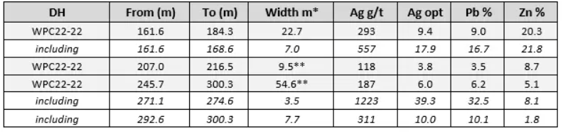
The above references an opinion and is for information purposes only. It is not intended to be investment advice. Seek a licensed professional for investment advice. The author is not an insider or shareholder of any of the companies mentioned above.
Kodiak Copper (TSXV:KDK) has announced a new high-grade gold-silver discovery on surface, being called the “Beyer Zone”. The discovery was made at the company’s 100%-owned MPD copper-gold porphyry project in British Columbia, Canada.
The ongoing trenching at the Beyer Zone was part of a regional exploration program aimed at evaluating untested copper-gold targets at the MPD property. This part of the project has been completed in parallel with its full-funded 25,000-metre drill program. The program consists of multiple copper-gold porphyry targets, which the company expects to continue to report results from.
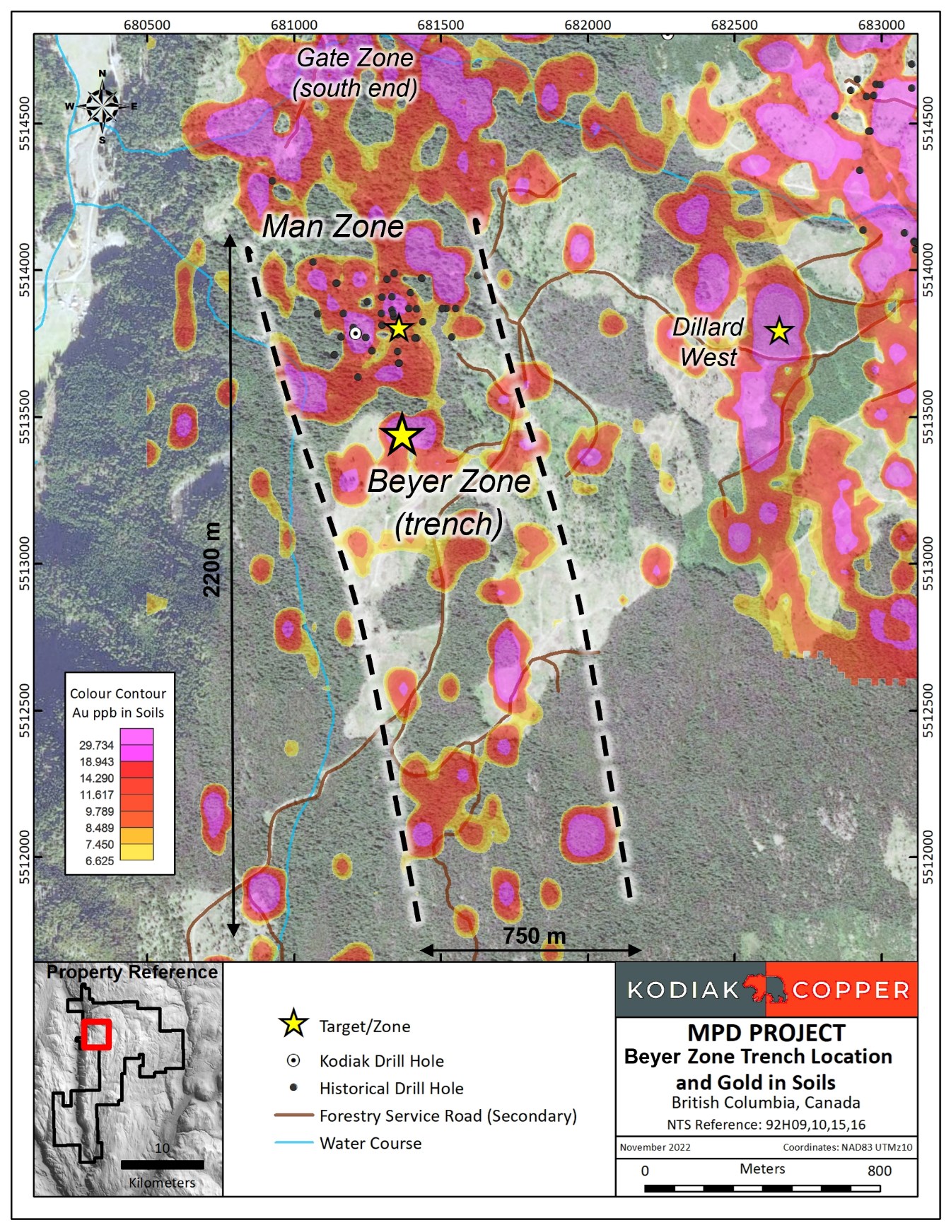
Claudia Tornquist, President and CEO of Kodiak, commented in a press release: “The Beyer gold-silver discovery is an exciting new development as it sits within a multi-kilometre, completely untested new gold-in-soil trend. It is remarkable because this is the first time sizable intervals of high-grade gold-silver mineralization have been trenched at the MPD project. Mineralization and alteration are open along strike, making extension of these trenches an obvious follow-up for 2023. The Beyer discovery is a testament to the outstanding prospectivity of the MPD Project and adds new upside and value creation potential for our shareholders.”
Highlights from the discovery are as follows:
- A 2022 surface sample taken prior to trenching the Beyer Zone assayed 14.15 grams per tonne (“g/t”) gold and 9.40 g/t silver. Figure 1 and Table 1
- Trench sampling expanded this new surface gold-silver discovery to 3.02 g/t gold and 24.18 g/t silver over 12 metres, including 5.29 g/t gold and 27.70 g/t silver over 2 metres in north-south Trench 22-015. Figure 1 and Table 1
- Trench sampling east-west also assayed 9.11 g/t gold and 24.00 g/t silver over 2 metres, with a parallel zone 8 metres west assaying 2.60 g/t gold and 10.10 g/t silver over 2 metres in Trench 22-016. Figure 1 and Table 1
- Approximately 14 metres of hydrothermally altered and mineralized rock has been exposed in the two trenches excavated to date, which remains open to extension. Figure 3
- The Beyer Zone discovery was made within a 2.2 kilometre long, 750 metre wide gold-in-soil corridor discovered during Kodiak’s 2019 and 2021 soil sampling. Figure 2
- Trenching at the Beyer Zone followed up gold-in-soil anomalies and a chip sample previously reported by Kodiak that assayed 11.75 g/t and 42.5 g/t silver over 2.3 metres. See news releases dated August 29, 2019 and February 3, 2022.
- The Beyer alteration zone hosting gold and silver mineralization contains elevated pathfinder elements such as arsenic, antimony, bismuth, and tellurium, which can be used for geochemical vectoring and new target generation across the MPD property.
- Extensive drilling at the nearby Gate and Man zones have demonstrated a close association between shallow bedrock mineralization and soil geochemistry. As such, the 2.2 kilometre by 750 metre gold-in-soil trend hosting the Beyer Zone is not expected to be primarily caused by glacial transport.
- The Beyer Zone is slated for additional trenching and drilling as part of the 2023 program.
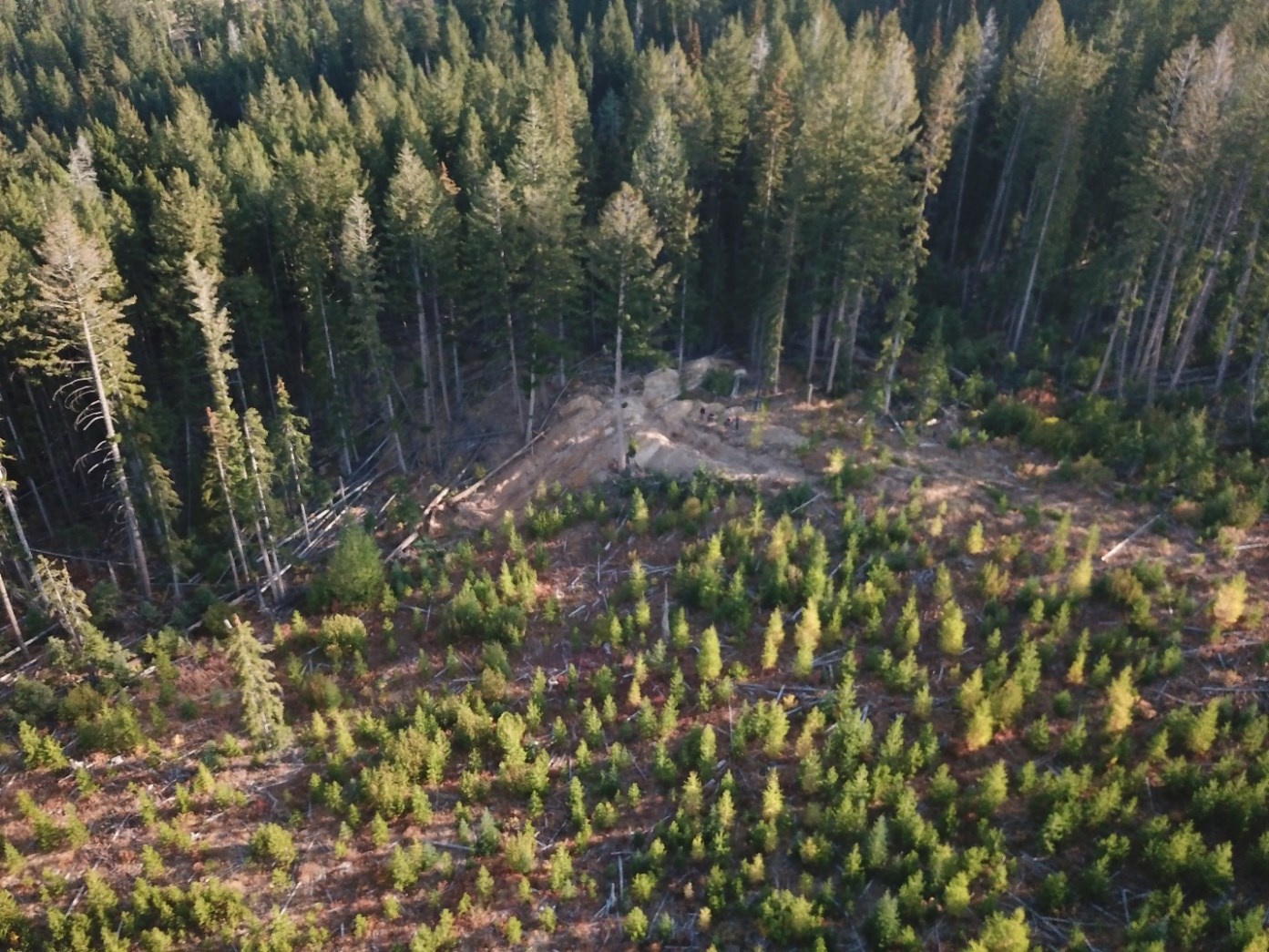
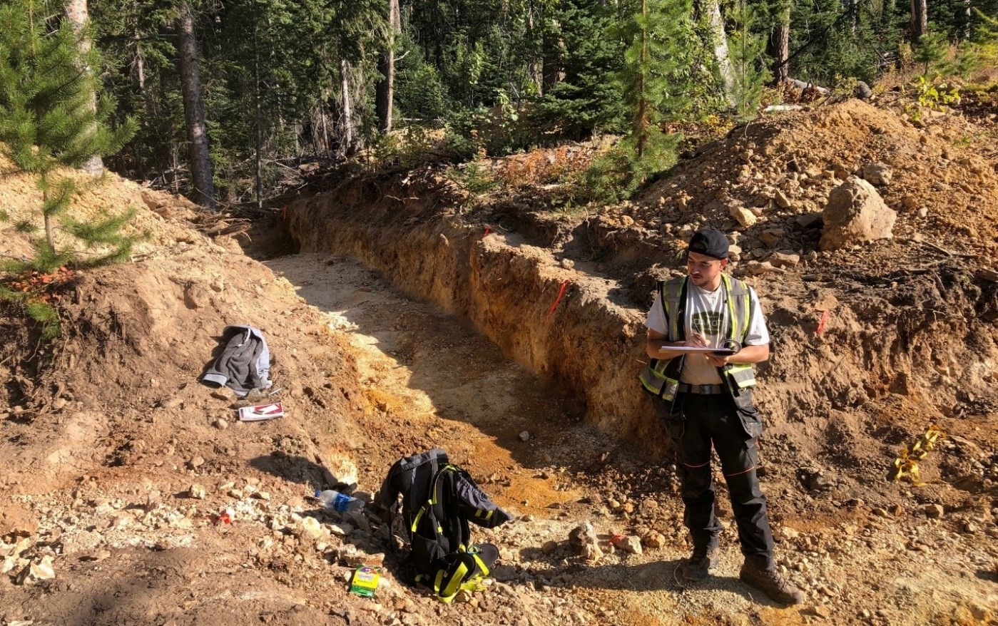
Table 1: Weighted assay intervals for 2022 Beyer Zone trench results; grab samples, trenches T-22-016 (west to east) and T-22-015 (south to north). See Figure 1
| ID | From (m) | To (m) | Interval (m)* | Au g/t | Ag g/t |
| 137084 | Grab | 14.15 | 9.4 | ||
| 137083 | Grab | 2.83 | 27.1 | ||
| West-East | |||||
| TRENCH-22-016 | 18 | 22 | 4 | 2.47 | 7.9 |
| includes | 18 | 20 | 2 | 9.11 | 24 |
| and | 8 | 10 | 2 | 2.6 | 10.1 |
| South-North | |||||
| TRENCH-22-015 | 14 | 26 | 12 | 3.02 | 24.18 |
| Includes | 20 | 24 | 4 | 4.7 | 30.45 |
| Includes | 22 | 24 | 2 | 5.29 | 27.7 |
*Sample intervals are 1 to 2 metre trench chip samples. Trench data to date is insufficient to determine true width or orientation of mineralisation.
Table 2: 2022 MPD Beyer Zone Trench Location Information (UTM Z10)
| Trench ID | Start Easting | Start Northing | End Easting | End Northing | Orientation | Zone | Reported |
| 137083 | 681400 | 5513438 | Grab | Beyer Zone | Dec 5, 2022 | ||
| 137084 | 681400 | 5513438 | Grab | Beyer Zone | Dec 5, 2022 | ||
| T-22-015 | 681396 | 5513423 | 681399 | 5513451 | S-N | Beyer Zone | Dec 5, 2022 |
| T-22-016 | 681377 | 5513444 | 681413 | 5513440 | W-E | Beyer Zone | Dec 5, 2022 |
The above references an opinion and is for information purposes only. It is not intended to be investment advice. Seek a licensed professional for investment advice. The author is not an insider or shareholder of any of the companies mentioned above.
Solaris Resources (TSX:SLS) (OTCQB:SLSSF) has reported assay results from a series of holes aimed at growing the Northeast Extension of its ‘Indicative Starter Pit’ at the Warintza Project. The company has defined a 1.5Bt copper inventory in an open pit with a low strip ratio at the Warintza Central deposit, and within that, a high-grade starter pit driving really robust economics, which makes it one of the best greenfield development copper opportunities available globally.
The newest results from the project continue to build on past successes of four significant discoveries, and expand the ‘Indicative Starter Pit’ previously estimated at 180Mt at 0.82% CuEq.
Mr. Jorge Fierro, Vice President, Exploration, commented in a press release: “The Northeast Extension remains open to the north with assays pending from recently completed holes. Further extensional drilling is planned with a 200m step-out platform on the northeastern margin of the drill grid aimed at expanding the zone in this direction. We’re also expecting assays from the remaining holes drilled from the discovery platform at Warintza West outlining a mineralized porphyry with minimum dimensions of 900m x 600m and open outside the MRE for future resource drilling, and the next series of holes targeting the expansion of Warintza East.”
Highlights from the results are as follows:
Resource expansion drilling continues to build on the Northeast Extension of the ‘Indicative Starter Pit’ which was estimated at 180 Mt at 0.82% CuEq¹ (Indicated) and 107 Mt at 0.73% CuEq¹ (Inferred) within the Warintza Mineral Resource Estimate² (“MRE”) based on drilling to the end of 2021. Follow-up drilling this year has significantly expanded the dimensions of the zone as a priority for high-impact growth with further drilling ongoing.
- SLS-67 was collared at the north-central limit of Warintza Central and drilled southwest into a partially open volume, returning 108m of 1.20% CuEq¹ within a broader interval of 604m of 0.51% CuEq¹ from near surface
- This hole expands on the area of high-grade near surface mineralization in combination with SLS-48 which was collared from the same platform but drilled south, returning 100m of 1.64% CuEq³ within a broader interval of 852m of 0.56% CuEq³ from near surface (refer to press release dated Feb 28, 2022)
- SLS-68 was collared from the same platform as SLS-67 and drilled steeply to the northwest into an open volume, returning 72m of 1.00% CuEq¹ within a broader interval of 616m of 0.44% CuEq¹ from near surface, expanding this area of higher-grade mineralization from near surface
- SLS-65 was collared from a recently constructed 250m step-out platform at the northeast limit of the Warintza Central grid and drilled northwest into a partially open volume, returning 286m of 0.55% CuEq¹ from near surface
- Assays are pending from a series of holes from this new drill platform aimed at further expanding resource growth in the Northeast Extension zone, with additional extension and step-out drilling underway
Figure 1 – Plan View of Warintza Central Drilling Released to Date
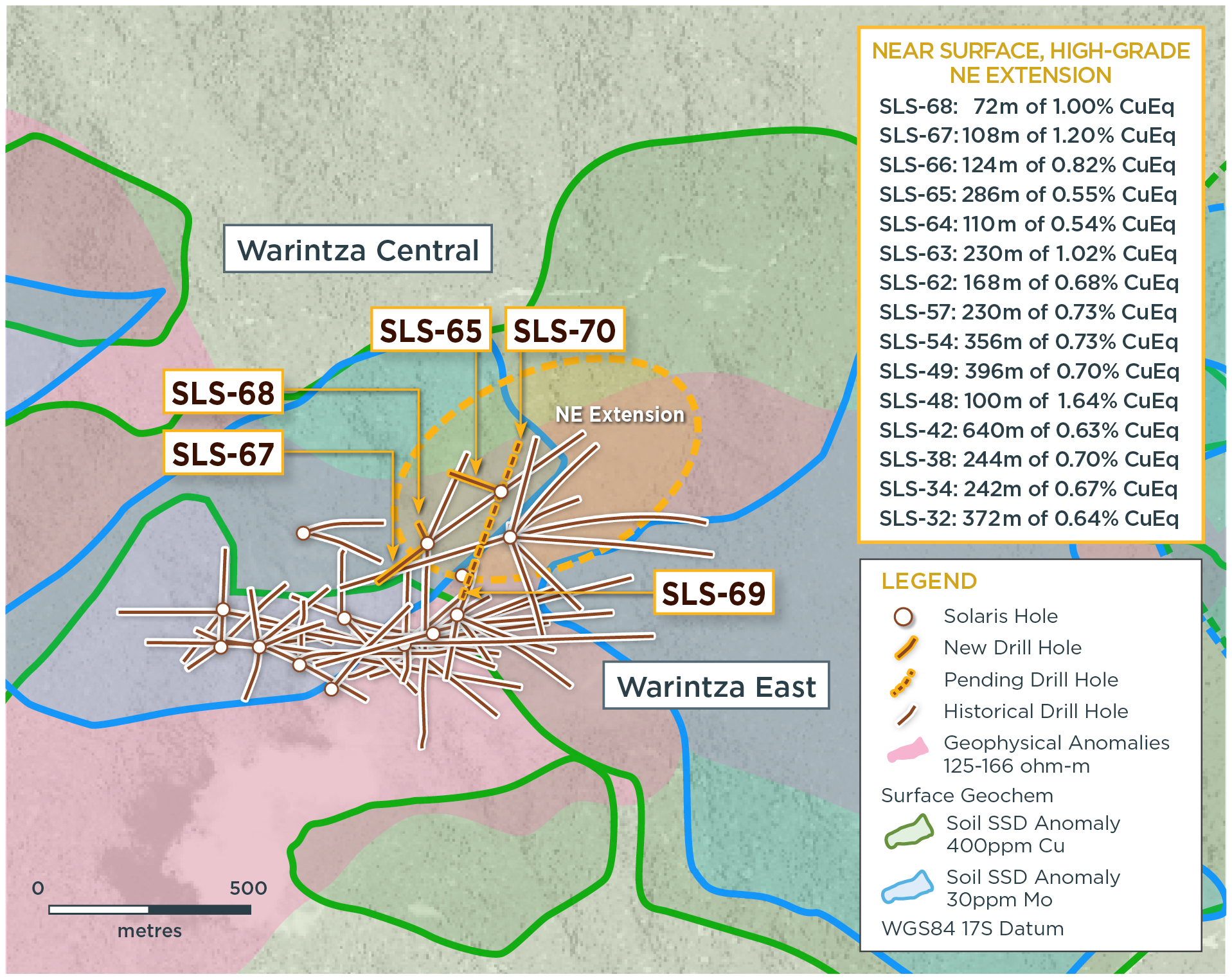
Table 1 – Assay Results
| Hole ID | Date Reported | From (m) | To (m) | Interval (m) | Cu (%) | Mo (%) | Au (g/t) | CuEq¹ (%) |
| SLS-68 | Dec 5, 2022 | 44 | 660 | 616 | 0.34 | 0.02 | 0.04 | 0.44 |
| Including | 68 | 140 | 72 | 0.88 | 0.02 | 0.06 | 1.00 | |
| SLS-67 | 42 | 646 | 604 | 0.40 | 0.02 | 0.05 | 0.51 | |
| Including | 42 | 150 | 108 | 1.06 | 0.03 | 0.09 | 1.20 | |
| SLS-65 | 88 | 374 | 286 | 0.38 | 0.04 | 0.06 | 0.55 | |
| Notes to table: True widths of the mineralized zone are not known at this time. | ||||||||
Table 2 – Collar Location
| Hole ID | Easting | Northing | Elevation (m) | Depth (m) | Azimuth (degrees) | Dip (degrees) |
| SLS-68 | 800178 | 9648285 | 1439 | 662 | 332 | -85 |
| SLS-67 | 800178 | 9648285 | 1439 | 673 | 230 | -76 |
| SLS-65 | 800347 | 9648415 | 1346 | 401 | 290 | -70 |
| Notes to table: The coordinates are in WGS84 17S Datum. | ||||||
The above references an opinion and is for information purposes only. It is not intended to be investment advice. Seek a licensed professional for investment advice. The author is not an insider or shareholder of any of the companies mentioned above.
Prismo Metals (CSE:PRIZ) has announced new assay results for its first five holes from the drill program at the Palos Verdes project. The company still expects assays for the last three holes of the 2022 campaign to arrive before the end of December. Located in the Panuco-Copala district of the state of Sinaloa, Mexico, the Palos Verdes concession covers 700 metres of strike length in the Palos Verdes vein.
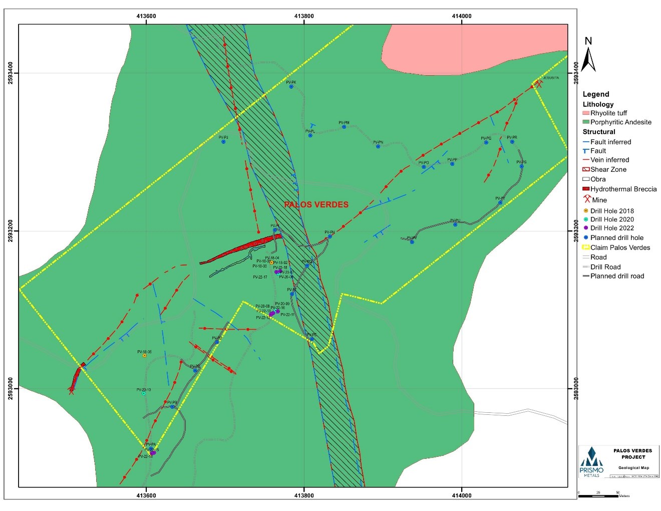
The first drill hole of the season, PV-22-11, cut 0.7 meters downhole length with 553g/t AgEq or 4.18 g/t gold and 207 g/t silver. All five holes reported here cut significant mineralization, and in general intercepts were relatively gold and base-metal rich (Table 1). The company has completed the current drill program with almost 2,100 meters drilled in eight holes as shown in Table 2.
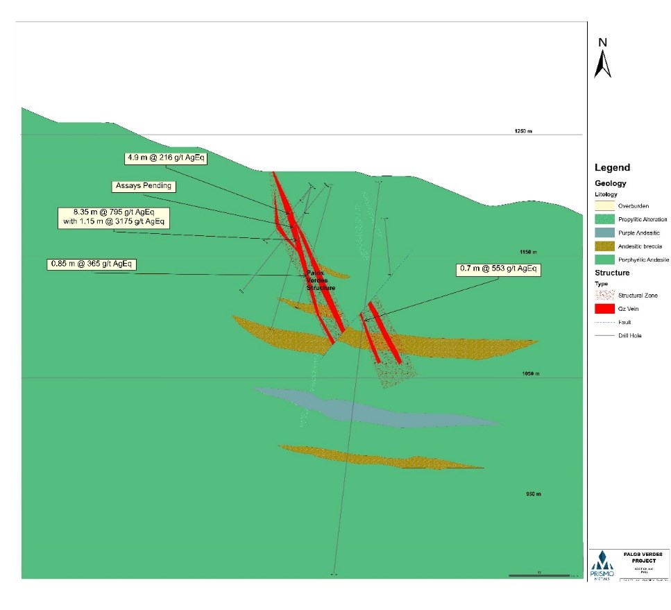
Several holes cut wide zones of mineralization, including nine meters downhole in hole PV-22-15 that averaged 187 g/t AgEq or 1.02 g/t Au with 1.1 % Pb and 1.4 % Zn. These intercepts shown in table 3 range from 50 to 150 meters below previous shallow drilling that had several high-grade intercepts. Table 3 shows the intercepts from the historic drilling with silver equivalent values shown for comparison purposes, with the best being 3,175 g/t AgEq over a true width estimated at 0.8 meters within a larger mineralized interval with 795 g/t AgEq over a true width of 5.5 meters.
Craig Gibson, President and CEO of Prismo Metals, commented in a press release: “The drill program was successful in extending the mineralization to depth below the shallow drill holes completed previously and provided important information on the distribution of metal values. Under the current environmental permit, we had access to limited drill sites, which leaves ample room to significantly extend the higher-grade zones in the mineralized ore shoot along strike.
“Approximately 70% of the strike length of the Palos Verdes vein remains untested, including the central portion of the southwestern segment of the vein, and all of the northeastern extension. In April of this year, we applied for an expanded environmental permit which we anticipate obtaining before our next phase of drilling planned for January 2023. Upon receipt of the expanded environmental permit, we will immediately initiate further drilling to the northeast to be funded by the announced strategic investment from Vizsla Silver Corp. Also, once this agreement with Vizsla is finalized, we will be able access the central portion of the southern segment of the Palos Verdes vein from roads on their adjacent concession, thereby further expanding our ability to explore the Palos Verdes property.”
Further results and a corporate update as provided by Prismo Metals include:
Prismo also provided an update on its short-term corporate priorities.
Prismo is currently working on finalizing the announced strategic investment by Vizsla Silver Corp. The strategic investment will provide for a cash injection to Prismo of $500,000 and issuance to Prismo of $1.5 million in Vizsla shares which will provide Prismo shareholders further exposure to the district via equity ownership position in Vizsla Silver.
The companies will also form a joint technical committee to allow for the pursuit of district-scale exploration of Panuco silver-gold district. This transaction is expected to be finalized by December 16, 2022. The next phase of drilling at Palos Verdes, expected in January 2023, will be reviewed by the technical committee to be formed as part of the agreement with Vizsla Silver.
At the Los Pavitos project, the surface mapping and sampling program begun early in 2022 continues, with completion of the initial mapping and sampling program over the concession slated for December. Preparation of the environmental permit application is in progress, field work has been completed and the application will be submitted shortly, with drilling planned in the first quarter of 2023.
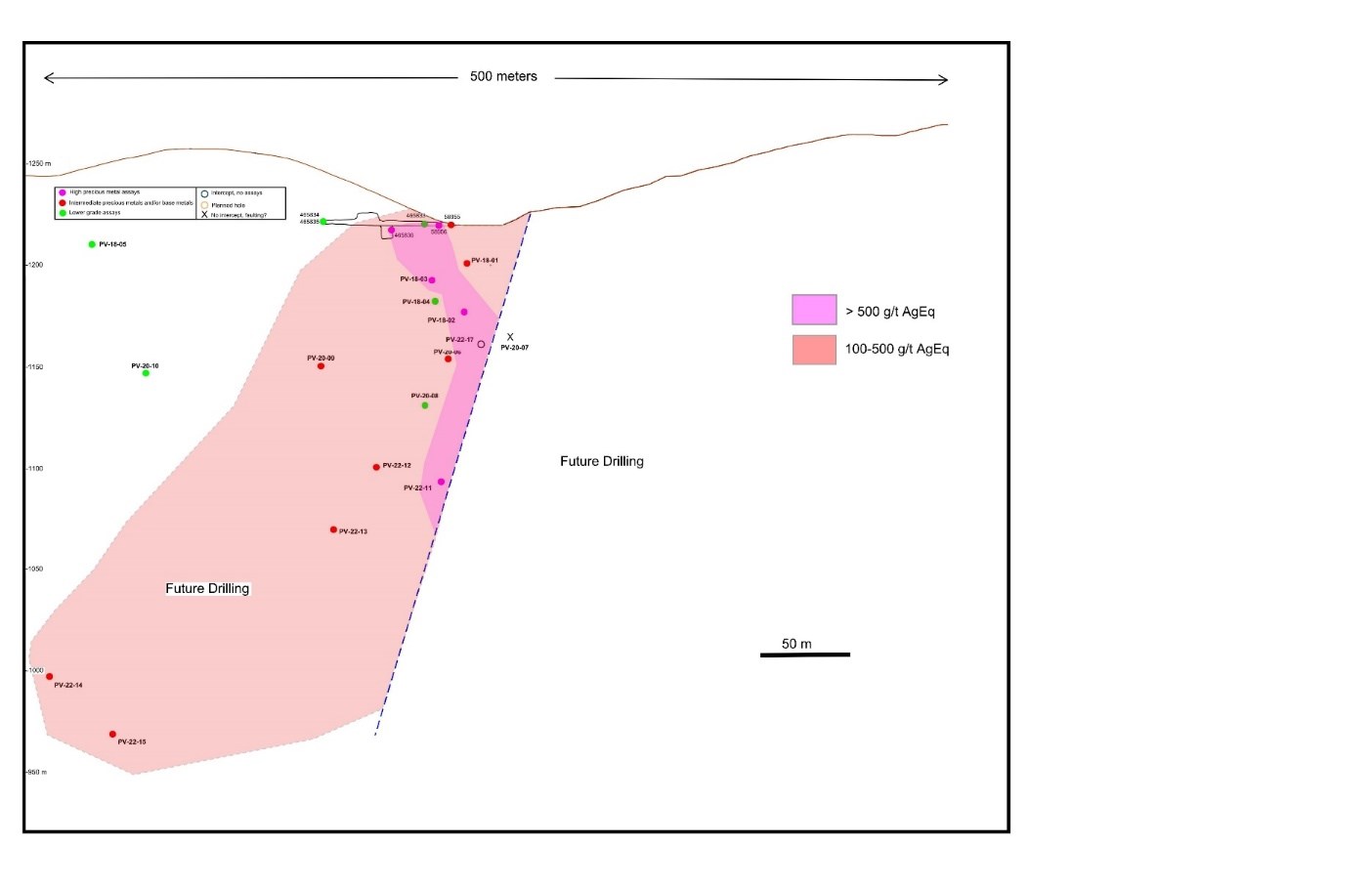
No drilling has been completed to the northeast of the fault. Source: Prismo Metals
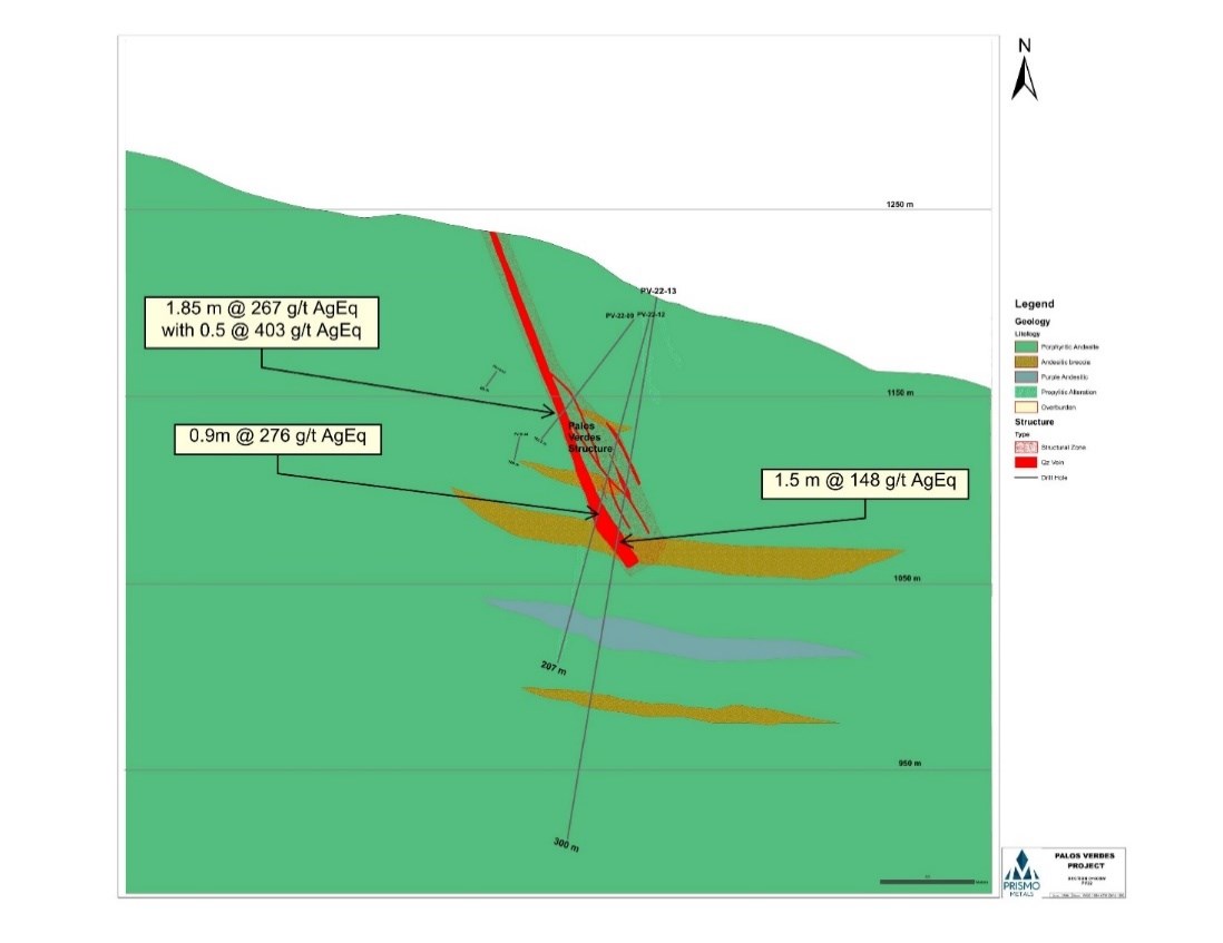
Table 1. Assays for drill holes in the current program.
| Hole | From
(m) |
To
(m) |
Width
(m) |
Est True
Width (m) |
Au
(g/t) |
Ag
(g/t) |
Cu
(%) |
Pb
(%) |
Zn
(%) |
Ag eq
(g/t) |
| PV-11 | 114.85 | 115.55 | 0.7 | 0.42 | 4.18 | 207 | 0.02 | 0.02 | 0.02 | 553 |
| PV-12 | 117.9 | 118.8 | 0.9 | 0.54 | 3.18 | 13 | 0.01 | – | – | 276 |
| PV-13 | 118.5 | 120.0 | 1.5 | 0.9 | 0.66 | 93 | – | – | – | 148 |
| PV-14 | 165.0 | 172.2 | 7.2 | 4.3 | 0.06 | 21 | 0.08 | 0.49 | 0.85 | 77 |
| incl | 169.4 | 171.0 | 1.6 | 2.5 | 0.07 | 28 | 0.12 | 0.52 | 1.01 | 88 |
| 179.9 | 184.2 | 4.3 | 2.6 | 0.03 | 27 | 0.41 | 0.81 | 1.01 | 92 | |
| 193.0 | 195.9 | 2.9 | 1.7 | 0.05 | 12 | 0.27 | 0.14 | 1.88 | 93 | |
| incl | 194.1 | 195.9 | 1.8 | 1.1 | 0.07 | 14 | 0.36 | 0.13 | 2.80 | 133 |
| PV-15 | 238.5 | 243.0 | 4.5 | 2.7 | 0.18 | 43 | 0.29 | 0.36 | 1.60 | 131 |
| 263.5 | 272.5 | 9 | 5.4 | 1.02 | 16 | 0.23 | 1.10 | 1.41 | 187 | |
| incl | 266.45 | 272.5 | 6.05 | 3.6 | 0.91 | 22 | 0.33 | 1.61 | 2.04 | 222 |
Silver equivalent values are calculated using the following metals prices: Au, US$1,750/oz, Ag, $21.24/oz, Pb, $0.97/lb and Zn, $1.34/lb. Cu was not used in the calculation, and metallurgical recoveries were not considered as there is no data available.
Table 2. Drill hole data for holes from the current program.
| Hole | Easting | Northing | Elev | Azim | Incl | Depth (m) | |
| PV-22-11 | 413,761 | 2,593,096 | 1,209 | 355 | -82 | 393.00 | |
| PV-22-12 | 413,759 | 2,593,095 | 1,209 | 325 | -75 | 207.00 | |
| PV-22-13 | 413,758 | 2,593,094 | 1,209 | 300 | -80 | 300.00 | |
| PV-22-14 | 413,610 | 2,529,919 | 1,230 | 330 | -75 | 303.00 | |
| PV-22-15 | 413,607 | 2,529,918 | 1,230 | 15 | -80 | 337.50 | |
| PV-22-16 | 413,767 | 2,593,098 | 1,209 | 70 | -60 | 288.00 | |
| PV-22-17 | 413,765 | 2,593,148 | 1,205 | 340 | -50 | 115.00 | |
| PV-22-18 | 413,770 | 2,593,149 | 1,205 | 40 | -50 | 156.00 | |
Coordinates in UTM WGS84 using handheld Garmin GPS.
Table 3. Drill results for all previously released drill holes at the Palos Verdes Project
| Hole | From
(m) |
To
(m) |
width
(m) |
Est True
width (m) |
Au
(g/t) |
Ag (g/t) | Cu
(%) |
Pb
(%) |
Zn
(%) |
Ag eq
(g/t) |
| PV-01 | 23.90 | 28.80 | 4.90 | 4.2 | 0.89 | 31 | 0.21 | 0.30 | 2.63 | 216 |
| PV-02 | 40.35 | 48.70 | 8.35 | 5.5 | 1.69 | 474 | 0.54 | 1.09 | 3.84 | 795 |
| incl. | 45.25 | 48.70 | 3.45 | 2.3 | 3.75 | 1098 | 0.67 | 1.99 | 3.00 | 1581 |
| incl. | 46.55 | 47.70 | 1.15 | 0.8 | 8.42 | 2336 | 0.27 | 1.72 | 2.46 | 3175 |
| PV-03 | 31.30 | 40.65 | 9.35 | 7.0 | 1.45 | 15 | 0.05 | 0.11 | 1.04 | 178 |
| incl. | 39.55 | 40.65 | 1.10 | 0.8 | 12.15 | 50 | 0.26 | 0.53 | 5.01 | 1263 |
| PV-04 | 55.45 | 59.00 | 3.55 | 3.0 | 0.12 | 37 | 0.31 | 0.12 | 0.74 | 121 |
| PV-05 | 54.25 | 57.40 | 3.15 | 2.0 | 0.25 | 23 | 0.06 | 0.32 | 0.62 | 77 |
| incl. | 56.40 | 57.40 | 1 | 0.42 | 30 | 0.12 | 0.83 | 1.27 | 138 | |
| PV-06 | 70.55 | 75.85 | 5.3 | 3.2 | 0.13 | 69 | 0.14 | 0.12 | 0.29 | 220 |
| 75.00 | 75.85 | 0.85 | 0.5 | 0.46 | 317 | 0.12 | 0.09 | 0.21 | 365 | |
| PV-07 | 32.40 | 34.20 | 1.8 | ? | 0.01 | 9 | 0.35 | 0.24 | 0.47 | 36 |
| PV-08 | 92.70 | 96.05 | 3.35 | 2.5 | 0.24 | 17 | 0.09 | 0.19 | 0.58 | 65 |
| 92.70 | 93.65 | 0.95 | 0.7 | 0.55 | 37 | 0.24 | 0.61 | 1.21 | 147 | |
| PV-09 | 87.10 | 88.95 | 1.85 | 1.3 | 0.73 | 38 | 0.19 | 0.61 | 3.89 | 267 |
| incl. | 87.10 | 87.60 | 0.5 | 0.3 | 1.63 | 44 | 0.27 | 0.79 | 5.15 | 403 |
| PV-10 | 125.30 | 126.50 | 1.20 | 0.9 | 0.03 | 6 | 0.06 | 0.03 | 1.4 | 71 |
Partial data for holes PV-01 to PV-10 were included in previous news releases, of September 30, 2020 and December 20, 2020 True width of the intercept in hole PV-07 is unknown.
The above references an opinion and is for information purposes only. It is not intended to be investment advice. Seek a licensed professional for investment advice. The author is not an insider or shareholder of any of the companies mentioned above.
Canada Nickel Company (TSXV:CNC) has announced new drill results from the ongoing regional drill campaign at the Reid and Sothman properties. The company received assay results that confirm the previous discovery made at Reid, with a higher-grade interval of 0.29% nickel, including 81 metres of 0.35% nickel. Canada Nickel has also made a new discovery at the Sothman property, with all five holes confirming mineralization.
Canada Nickel is currently advancing several nickel-sulphide projects to deliver the nickel required for EV and steel markets. These high-growth markets continue to be a main point of focus for the industry, as rising demand is set to outstrip supply in the coming years and new discoveries become critical for the mining industry.
Mark Selby, Chair & CEO of Canada Nickel, commented in a press release: “We continue to have excellent success with our regional exploration program. The latest results provide further confirmation of the potential at Reid with a large higher-grade interval in hole REI22-07 and multiple holes well-mineralized across their entire core lengths. Our targeting approach was further confirmed with another bulk tonnage discovery at Sothman with all five holes intersecting mineralization. These latest results continue to reinforce the success of our geophysical targeting approach and increase the probability of success at our other 20-plus properties within the 42 km2 of geophysical targets. We look forward to drilling our high-grade target at Sothman where historical drilling achieved multiple intervals greater than 1% nickel.”
Highlights from the drill results are as follows:
- Additional assay results confirm scale of discovery at Reid
- Higher grade interval at Reid – REI22-07 325 metres of 0.29% nickel including 81 metres of 0.35% nickel
- New discovery at Sothman
Reid Nickel Property
The Reid Property is located just 16 km southwest of Crawford, or 37 km northwest of Timmins, and contains an ultramafic body with a target geophysical footprint of 3.9 km2 (see Figure 1). Preliminary assay results from our summer/fall drilling program confirms the presence of mineralized dunite, as well as currently undefined higher-grade sections. Partial assay results confirm expected nickel grades (Table 1). Nickel mineralization in serpentinized dunite was found in all 16 holes drilled to date.
This release provides an update with assays from five more holes to a total of eight holes with complete assays. True widths are unknown at this point. Hole REI22-07 collared near the center of the anomaly in dunite containing a series of late dykes and remained in a strongly serpentinized, moderate to strongly mineralized dunite to the end of the hole. The hole averaged 0.29% nickel over 325.5 metres, including a wide higher-grade section with 0.35% nickel over 81.5 metres. The hole then continued through mineralized dunite that averaged 0.27% nickel over the last 132 metres of the hole.
REI22-03 collared in dunite on the east flank of the anomaly and was drilled to the west. The hole intersected 358.4 metres of dunite and finished in dunite, interrupted by a late dyke in the center. The hole shows moderate to strong serpentinization and visible pentlandite-heazlewoodite mineralization averaging 0.24% nickel over 223.1 metres.
REI22-04 collared in peridotite on the east flank of the anomaly 500 metres north of REI22-03, drilling to the northeast. The hole intersected peridotite, followed by dunite only interrupted by minor dykes. The hole averaged 0.19% nickel over 269.8 metres and 0.21% nickel over 79 metres.
REI22-05 collared in dunite and remained in dunite to the end of hole, only interrupted by a small late dyke. The hole was collared near the center of the anomaly and drilled to the west. The hole was strongly serpentinized throughout and averaged 0.24% nickel over 409.5 metres including 0.26% nickel over 55.5 metres.
REI22-08 collared in dunite on the same setup as REI22-03 but drilling to the northwest. The hole remained in dunite to the end of the hole, encountering minor peridotite sections. The hole averaged 0.24% nickel over 372.8 metres, including 0.26% nickel over 63 metres.
Results from the remaining eight holes are still pending, but with the encouraging results as provided in this release, Canada Nickel plans to resume drilling in 2023. The south limb of the anomaly remains to be drilled.
Table 1: Reid exploration drilling results
| Hole ID | From | To | Length | Ni | Co | Pd | Pt | Cr | Fe | S |
| (m) | (m) | (m) | ( %) | ( %) | (g/t) | (g/t) | ( %) | ( %) | ( %) | |
| REI22-03 | 58.6 | 354.0 | 295.4 | 0.24 | 0.01 | 0.003 | 0.003 | 0.80 | 5.51 | 0.04 |
| including | 140.8 | 259.5 | 118.7 | 0.25 | 0.01 | 0.003 | 0.003 | 0.84 | 5.34 | 0.04 |
| REI22-04 | 48.5 | 318.3 | 269.8 | 0.19 | 0.01 | 0.005 | 0.007 | 0.61 | 6.31 | 0.08 |
| and | 338.0 | 417.0 | 79.0 | 0.21 | 0.01 | 0.010 | 0.007 | 0.57 | 6.30 | 0.11 |
| REI22-05 | 52.5 | 462.0 | 409.5 | 0.24 | 0.01 | 0.004 | 0.005 | 0.76 | 5.63 | 0.06 |
| including | 380.5 | 436.0 | 55.5 | 0.26 | 0.01 | 0.007 | 0.005 | 0.82 | 4.90 | 0.09 |
| REI22-07 | 136.5 | 462.0 | 325.5 | 0.29 | 0.01 | 0.028 | 0.010 | 0.75 | 5.38 | 0.08 |
| including | 147.0 | 228.5 | 81.5 | 0.35 | 0.01 | 0.050 | 0.015 | 0.74 | 5.40 | 0.10 |
| REI22-08 | 57.2 | 430.0 | 372.8 | 0.24 | 0.01 | 0.004 | 0.006 | 0.85 | 6.11 | 0.08 |
| including | 229.0 | 292.0 | 63.0 | 0.26 | 0.01 | 0.003 | 0.005 | 0.94 | 5.59 | 0.07 |
Sothman Nickel Property
The Sothman property is located 70 km south of Timmins and contains an ultramafic target that measures 2.2 km east-west by 200 metres north-south (Figure 2).
Five drillholes were drilled on the eastern half of the target anomaly (SOT22-01 to SOT22-05). These holes succeeded in confirming the continuation of ultramafic lithologies, primarily peridotite, with moderate to strong serpentinization and variable amounts of mineralization throughout (see Table 2). Assays from all holes are pending.
Table 2: Sothman Selected lithology intervals
| Hole # | From | To | length | Rock Type |
| SOT22-01 | 39.7 | 77.0 | 37.3 | Pyroxenite |
| 77.0 | 234.7 | 157.7 | Dunite | |
| SOT22-02 | 48.3 | 77.0 | 33.3 | Dunite |
| 77.0 | 149.0 | 72.0 | Peridotite | |
| 149.0 | 201.5 | 52.5 | Dunite | |
| 201.5 | 266.0 | 64.5 | Peridotite | |
| SOT22-03 | 39.5 | 143.0 | 103.5 | Dunite |
| 143.0 | 184.9 | 41.9 | Peridotite | |
| SOT22-03 | 39.5 | 143.0 | 103.5 | Dunite |
| 143.0 | 184.9 | 41.9 | Peridotite | |
| SOT22-04 | 40.0 | 90.0 | 50.0 | Peridotite |
| 117.0 | 125.0 | 8.0 | Peridotite | |
| SOT22-05 | 38.0 | 245.0 | 207.0 | Peridotite |
| 245.0 | 315.5 | 70.5 | Dunite | |
| 315.5 | 353.0 | 37.5 | Peridotite |
The above references an opinion and is for information purposes only. It is not intended to be investment advice. Seek a licensed professional for investment advice. The author is not an insider or shareholder of any of the companies mentioned above.
If you would like to receive our free newsletter via email, simply enter your email address below & click subscribe.
 Follow us on Twitter
 Become our facebook fan
CONNECT WITH US
Tweets
Tweet with hash tag #miningfeeds or @miningfeeds and your tweets will be displayed across this site.
MOST ACTIVE MINING STOCKS
Daily Gainers
 CMC Metals Ltd. CMC Metals Ltd. |
CMB.V | +900.00% |
 Eden Energy Ltd Eden Energy Ltd |
EDE.AX | +200.00% |
| GoviEx Uranium Inc. |
GXU.V | +42.86% |
| Eagle Nickel Ltd. |
ENL.AX | +41.67% |
| Citigold Corp. Limited |
CTO.AX | +33.33% |
| Mount Burgess Mining NL |
MTB.AX | +33.33% |
| Exalt Resources Limited |
ERD.AX | +31.94% |
| Casa Minerals Inc. |
CASA.V | +30.00% |
| Cariboo Rose Resources Ltd |
CRB.V | +28.57% |
| Belmont Resources Inc. |
BEA.V | +28.57% |