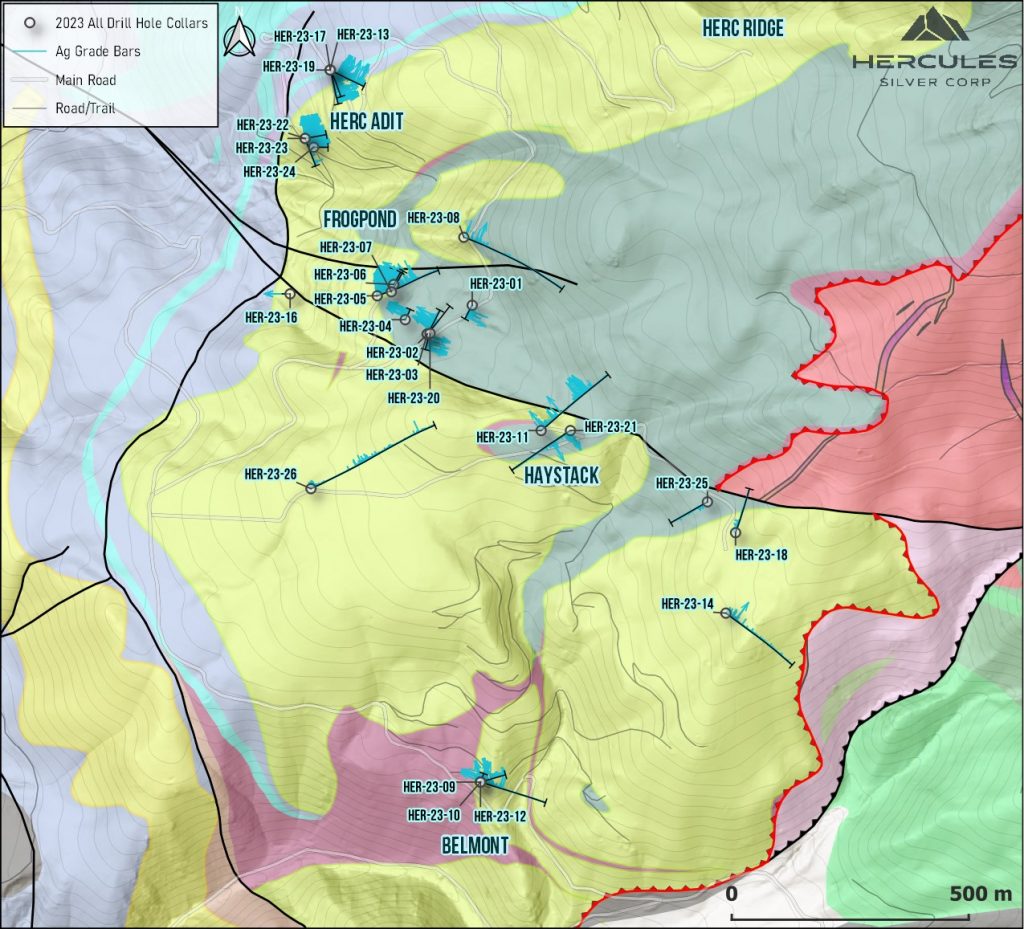
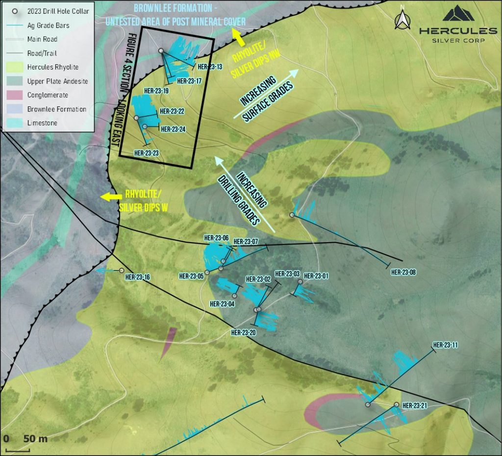
Hercules Silver (TSXV:BIG) has announced that recent drilling at its Hercules Silver Property in western Idaho has encountered significant silver-lead-zinc mineralization in the shallow holes above the newly discovered Leviathan porphyry copper deposit.
The drilling indicates increasing silver grades toward the northwest, moving closer to the Hercules Adit Zone. This trend mirrors the increase in copper grades seen at deeper levels in the Leviathan porphyry system. The correlation between silver and copper suggests a potential relationship between the two mineralization styles, possibly representing different vertical levels within the porphyry system.
Chris Paul, CEO and Director of the Company, commented in a press release: “We’re encouraged to see another line of evidence for increasing grades to the northwest as we work closely with Barrick Gold Corporation’s senior technical team to plan our 2024 drill campaign. The program will be aimed at systematically stepping out on the Leviathan porphyry copper discovery as well as testing a multitude of new targets identified by our team. The objective is to have three diamond core rigs operational on site to complete a series of systematic step-outs from discovery hole HER-23-05, as well as several larger scale step-outs, and scout drilling of select reconnaissance targets. We look forward to sharing the details of the drill plan as we finalize specific targets in advance of the field season. We’d also like to thank Barrick for the tremendous technical support they’ve provided us with so far. I’m proud of our teams combined efforts and cooperation at interpreting the data and generating a robust 3D model for use towards the drill planning.”
In some porphyry deposits, late-stage silver mineralization can migrate upward along structures above the main porphyry centre. The flat-lying silver mineralization in the Hercules Rhyolite may have originated from a feeder structure connecting to a deeper porphyry source.
The most promising silver grades were intersected at the Hercules Adit Zone. Grades may continue to improve at depth, below the post-mineral Brownlee Formation. Significant silver and copper have been found at surface exposures farther north at the Hercules Ridge and Grade Creek zones. Historical mining in the early 1900s at the Belmont Zone also reported notable copper.
Hercules Silver plans to prioritize these northern zones for drilling in 2024, given the compelling surface mineralization and geophysical trends that point to porphyry potential at depth. The company is looking to further explore the relationship between silver mineralization in the shallow units and potential underlying porphyry copper sources.
Highlights from the results are as follows:
- HER-23-17 extended the high-grade Hercules Adit footwall shoot down plunge, with 11.3 Meters of 1,660 g/t Ag, 0.7% Pb, 1.75% Zn, one of the best silver intercepts on the Property, within an overall 112.2 Meters of 193 g/t Ag, 0.2% Pb, 0.4% Zn.
- HER-23-19 intersected a potentially new mineralized shoot at the hanging wall contact of the Hercules Adit Zone, returning 15.3 Meters of 359 g/t Ag, 0.4% Pb, 0.4% Zn.
- HER-23-13 intersected 100.1 Meters of 64 g/t Ag, 0.14% Pb, 0.49% Zn including 6.1 Meters of 413 g/t Ag, 1.1% Pb, 1.7% Zn.
- HER-23-09 intersected 32.2 Meters of 167 g/t Ag, 0.17% Zn.
- HER-23-22 intersected 58.8 Meters of 140 g/t Ag, 0.43% Pb, 0.69% Zn including 13.7 Meters of 280 g/t Ag, 0.3% Pb, 0.8% Zn.
- HER-23-23 intersected 43.9 Meters of 138 g/t Ag, 0.37% Pb, 0.32% Zn including 1.5 Meters of 1,450 g/t Ag, 1.06% Pb, 0.17% Zn.
- The highest silver grades are concentrated at the Hercules Adit Zone, indicating a strengthening trend to the north, in alignment with the copper mineralization observed in the underlying porphyry copper system (Refer to the Company’s January 22, 2024 News Release).
- The Hercules Adit Zone continues to remain open down plunge, extending towards a potential porphyry copper target.
- Planning for the 2024 drill campaign is underway, with the program scheduled to commence when weather conditions permit. Additional details regarding the drill plan will be disclosed as targets are finalized.
Table 1: Significant Intercepts* at the Hercules Adit Zone
| Hole ID | From (m) | To (m) | Interval (m) | Ag (g/t) | Pb (%) | Zn (%) | Mn (%) |
| HER-23-13 | 40.23 | 140.36 | 100.1 | 64 | 0.14 | 0.49 | 1.0 |
| including | 44.81 | 50.90 | 6.1 | 413 | 1.10 | 1.70 | 3.7 |
| including | 97.29 | 99.49 | 2.2 | 560 | 0.17 | 0.19 | 2.0 |
| including | 130.06 | 131.58 | 1.5 | 723 | – | 0.19 | 1.2 |
| HER-23-17 | 39.47 | 151.70 | 112.2 | 193 | 0.18 | 0.43 | 1.4 |
| including | 39.47 | 54.25 | 14.8 | 118 | 0.16 | 0.31 | 2.1 |
| including | 136.64 | 147.89 | 11.3 | 1,660 | 0.70 | 1.75 | 2.4 |
| HER-23-19 | 34.75 | 50.08 | 15.3 | 359 | 0.40 | 0.40 | 2.0 |
| AND | 82.24 | 85.80 | 3.6 | 142 | 0.56 | 0.74 | 1.2 |
| HER-23-22 | 0.00 | 58.83 | 58.8 | 140 | 0.43 | 0.69 | 2.0 |
| including | 45.11 | 58.83 | 13.7 | 280 | 0.30 | 0.80 | 3.7 |
| HER-23-23 | 0.00 | 38.10 | 43.9 | 138 | 0.37 | 0.32 | 2.6 |
| including | 25.91 | 38.10 | 12.2 | 398 | 0.40 | 0.46 | 4.9 |
| including | 25.91 | 27.43 | 1.5 | 1,450 | 1.06 | 0.17 | 3.9 |
| HER-23-24 | 19.81 | 29.11 | 9.3 | 61 | 0.75 | 0.15 | 1.1 |
Table 2: Significant Intercepts* at the Belmont Zone
| Hole ID | From (m) | To (m) | Interval (m) | Ag (g/t) | Pb (%) | Zn (%) | Mn (%) |
| HER-23-09 | 0.00 | 32.19 | 32.2 | 167 | – | 0.17 | 1.7 |
| HER-23-10 | 0.00 | 12.19 | 12.2 | 58 | – | 0.14 | 1.0 |
| HER-23-12 | 0.00 | 21.18 | 21.2 | 137 | – | 0.18 | 1.0 |
| including | 18.47 | 19.66 | 1.2 | 1813 | – | 0.16 | 1.2 |
Table 3: Significant Intercepts* at the Frogpond Zone
| Hole ID | From (m) | To (m) | Interval (m) | Ag (g/t) | Pb (%) | Zn (%) | Mn (%) |
| HER-23-15 | LOST. REDRILLED AS HER-23-16 | ||||||
| HER-23-16 | 115.06 | 130.76 | 15.7 | 163 | 0.27 | 0.17 | 3.9 |
*The intervals reported represent drill intercepts and insufficient data are available at this time to state the true thickness of the mineralized intervals.
Table 4: Upper Plate Silver Intercepts* in Deep Porphyry Drill Holes
| Hole ID | From (m) | To (m) | Interval (m) | Ag (g/t) | Pb (%) | Zn (%) | Mn (%) | Notes |
| HER-23-08 | 0.00 | 104.00 | 104.0 | 10 | – | 0.19 | 1.4 | |
| HER-23-11 | 12.98 | 44.96 | 32.0 | 14 | – | 0.13 | 0.8 | |
| AND | 71.93 | 81.93 | 10.0 | 17 | 0.19 | 1.30 | 2.4 | |
| HER-23-20 | 19.29 | 45.87 | 26.6 | 103 | 0.24 | 1.1 | HER-23-20 designed to target porphyry but was lost immediately before intersecting lower plate | |
| AND | 199.80 | 223.72 | 23.9 | 46 | 1.0 | |||
| including | 199.80 | 204.22 | 4.4 | 70 | 0.14 | 0.17 | 1.3 | |
| including | 222.50 | 223.72 | 1.2 | 564 | – | 0.11 | 0.6 | Hole lost after this sample |
| HER-23-21 | 0.00 | 25.91 | 25.9 | 32 | 0.10 | 1.5 | ||
| including | 0.00 | 13.72 | 13.7 | 52 | 1.2 |
*The intervals reported represent drill intercepts and insufficient data are available at this time to state the true thickness of the mineralized intervals.
Table 5: Reported Drill Hole Locations
| Hole ID | Easting | Northing | Elevation | Depth (m) | Azimuth | Dip |
| HER-23-08 | 511414 | 4956760 | 1402 | 713.9 | 110 | -70.0 |
| HER-23-09 | 511449 | 4955610 | 1246 | 77.4 | 73.69 | -44.8 |
| HER-23-10 | 511449 | 4955610 | 1246 | 220.8 | 106.93 | -44.8 |
| HER-23-11 | 511577 | 4956352 | 1430 | 419.2 | 50.2 | -60.5 |
| HER-23-12 | 511449 | 4955610 | 1246 | 49.7 | 24.9 | -65.3 |
| HER-23-13 | 511132 | 4957113 | 1340 | 159.4 | 115.1 | -56.9 |
| HER-23-14 | 511966 | 4955967 | 1436 | 378.5 | 126.7 | -59.9 |
| HER-23-15 | 511061 | 4956765 | 1278 | 43.9 | 190.1 | -60.2 |
| HER-23-16 | 511039 | 4956641 | 1291 | 136.1 | 0 | -90.0 |
| HER-23-17 | 511132 | 4957113 | 1340 | 158.7 | 164.99 | -63.7 |
| HER-23-18 | 511987 | 4956137 | 1449 | 151.5 | 19.71 | -50.4 |
| HER-23-19 | 511132 | 4957113 | 1340 | 185.2 | 151.99 | -71.0 |
| HER-23-20 | 511342 | 4956557 | 1372 | 226.0 | 200.29 | -80.1 |
| HER-23-21 | 511638 | 4956352 | 1436 | 1007.1 | 240.43 | -80.2 |
| HER-23-22 | 511079 | 4956969 | 1293 | 76.6 | 79.81 | -55.0 |
| HER-23-23 | 511079 | 4956969 | 1293 | 87.7 | 159.96 | -45.1 |
| HER-23-24 | 511097 | 4956950 | 1291 | 42.7 | 90.17 | -44.9 |
| HER-23-25 | 511927 | 4956202 | 1438 | 126.4 | 240.5 | -45.3 |
| HER-23-26 | 511091 | 4956230 | 1349 | 799.6 | 64.89 | -64.7 |
The above references an opinion and is for information purposes only. It is not intended to be investment advice. Seek a licensed professional for investment advice. The author is not an insider or shareholder of any of the companies mentioned above.
Nuclear Fuels (CSE:NF) has reported positive results from its ongoing drill program at the Kaycee Uranium Project located in Wyoming’s Powder River Basin.
The program confirmed and expanded historic uranium mineralization at both the Spur Zone and the Saddle Zone, which are located two miles apart from each other along the trend. The final results from the 2023 program include:
- Saddle Zone: Three drill holes intersected significant uranium zones.
- Spur Zone: Five holes showed positive results from the initial drilling.
Drill depths ranged from 350 to 600 feet, with ten of the eighteen holes detecting anomalous uranium mineralization.
Michael Collins, Chief Executive Officer, commented in a press release: “Drilling 2023 validated and expanded on the robust nature of Kaycee uranium mineralization. The company is well funded and building the 2024 program to test and expand on high priority targets along the over 110 miles of roll fronts identified along the 33 mile long trend we have at Kaycee. Nuclear Fuels will continue to expand and add to its project portfolio as its active research program uncovers more valuable uranium projects.”
The 2023 program included a total of 89 drill holes. Planning is underway for a larger program scheduled to begin in early Q2-2024.
Kaycee Uranium Project
The Kaycee Project is Nuclear Fuels’ priority project and covers over 42 square miles of mineral rights within the Powder River Basin. It boasts a 33-mile mineralized trend hosting over 110 miles of identified roll fronts.
The project is believed to be unique in the region, as it encompasses all three historically productive sandstone formations (Wasatch, Fort Union, and Lance) potentially suitable for In-Situ Recovery (ISR) extraction. Notably, the Kaycee Project marks the first time since the early 1980s that the entire district has been under the control of a single company, Nuclear Fuels.
Nuclear Fuels acquired the Kaycee Project from enCore Energy Corp., which holds a back-in right to acquire 51% ownership by fulfilling specific financial obligations.
Wyoming: A Leading Uranium Producer
Wyoming has a long history of uranium production and boasts a supportive regulatory environment for ISR projects. As one of the few “Agreement States,” Wyoming enjoys streamlined permitting processes compared to most other states due to the transfer of regulatory authority from the federal government to the state.
The state ranks second in the nation for historic uranium production, exceeding 250 million pounds, with the majority extracted through ISR methods since 1990, primarily within the Powder River Basin.
Highlights from the results are as follows:
- Spur Zone mineralization was intersected on trend 2 miles northwest of the Saddle Zone with hole SR23-002 returning 3.5 feet of 0.141% U3O8 from a depth of 415.5 feet and 4.5 feet of 0.223% U3O8 from a depth of 422.0 feet for a combined GT of 1.543. (Grade Thickness or GT is the thickness times the grade; GTs in excess of 0.25 are considered suitable for inclusion in a potential wellfield.)
- Holes SR23-001 and SR23-006 both returned impressive GTs of 0.912 and 0.630 respectively from similar depths.
- Permitting is ongoing to:
- Expand the area under the Drill Notice with Wyoming Department of Environmental Quality, and
- Expand the permitted number of drill holes in that program to a minimum of 600 holes in the 2024 drill season.
Table of Significant Results
|
Drill Hole ID |
From (ft) |
Thickness (ft) |
% Grade U3O8 |
GT (grade x |
Total Hole |
|
SD23_079 |
247.5 |
1.5 |
0.036 |
0.054 |
|
|
SD23_080 |
262.5 |
4.5 |
0.071 |
0.320 |
|
|
SD23_081C |
277.0 |
6.0 |
0.081 |
0.486 |
|
|
SR23_001 |
401.5 |
5.5 |
0.141 |
0.776 |
|
|
SR23_001 |
413.5 |
2.0 |
0.068 |
0.136 |
0.912 |
|
SR23_002 |
415.5 |
3.5 |
0.141 |
0.494 |
|
|
SR23_002 |
422.0 |
4.5 |
0.233 |
1.049 |
1.543 |
|
SR23_003 |
389.0 |
2.5 |
0.052 |
0.130 |
|
|
SR23_004 |
364.5 |
1.5 |
0.032 |
0.048 |
|
|
SR23_006 |
416.0 |
3.0 |
0.117 |
0.351 |
|
|
SR23_006 |
432.5 |
3.0 |
0.093 |
0.279 |
0.630 |
|
Drill holes are reported that returned significant zones of uranium mineralization with >2 ft thickness at or above a grade cut-off of 0.02 per cent eU3O8 or that are relevant to exploration targeting. (1) %U3O8 by Gamma logging is a measure of gamma intensity from a decay product of uranium. Gamma log assays may be in disequilibrium with ICP-MS assays. Comparisons of U3O8 Gamma log and ICP-MS assays of Powder River Basin core samples indicate that U3O8 Gamma is comparable to ICP-MS uranium assay in the Powder River Basin. (2) Grade Thickness, or GT, is defined as the product of the mineral grade multiplied by the thickness of the mineralization. |
The above references an opinion and is for information purposes only. It is not intended to be investment advice. Seek a licensed professional for investment advice. The author is not an insider or shareholder of any of the companies mentioned above.
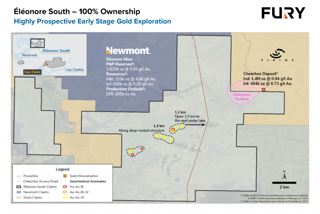
Canadian gold miner Fury Gold Mines (TSX:FURY) announced on Monday that it has reached an agreement with Newmont Corporation (TSX:NGT) to acquire Newmont’s 49.978% interest in the Éléonore South gold project in Quebec, Canada for CAD$3 million (approximately US$2.2 million).
As part of the deal, Fury Gold will also purchase around 30.4 million shares of Sirios Resources held by Newmont for investment purposes, spending CAD$1.3 million (nearly US$960,000) to do so.
Tim Clark, CEO of Fury Gold Mines, commented in a press release: “We value the strong relationship with Newmont and are confident that this transaction is a positive outcome for both companies. Our team has historically ranked the ESJV as one of our more prolific targets for discovery. As such, we are excited to now have 100% ownership as we expect this to provide a clearer pathway for more exploration and potential upside in returns for our investors from this project consolidation and investment in Sirios.
The Éléonore South project is located in a region with significant gold deposits. Newmont’s Éléonore gold mine lies to the north, while Sirios Resources’ Cheechoo deposit is positioned to the east.
Previous exploration at Éléonore South has identified two types of gold mineralization – high-grade structurally-controlled quartz veins hosted in sedimentary rocks, similar to Éléonore, and lower-grade disseminated intrusion-related gold mineralization akin to Cheechoo. Numerous untested gold anomalies remain throughout the property and will be a priority for Fury Gold.
At Cheechoo’s JT and Moni prospects, historical drilling has intercepted intervals including 53.3 meters of 4.22 g/t gold, 6.0 meters of 49.50 g/t gold and 23.8 meters of 3.08 g/t gold. Several of these holes require follow-up drilling and remain open.
The acquisition comes after Newmont announced plans last week to divest six non-core assets, including Éléonore, to pay down debt. The other assets are the Musselwhite and Porcupine mines in Ontario, the Coffee project in Yukon, and a 70% stake in the Havieron joint venture with Greatland Gold in Western Australia.
Newmont said it intends to focus on its portfolio of Tier 1 assets and emerging Tier 1 assets, sequencing development projects and enhancing capabilities to advance its pipeline of gold and copper projects. It has identified an additional $500 million in cost and productivity improvements.
By 2028, Newmont is targeting 6.7 million ounces of gold production and 8.3 million gold equivalent ounces. Average annual sustaining capital expenditure of $1.5 billion is expected over the next five years, along with average development capital of $1.3 billion per year.
Fury Gold Mines is a Canada-focused gold exploration company with projects in Quebec and British Columbia. It also holds a 59.5 million share position in Dolly Varden Silver Corp, representing 22% of issued shares.
The above references an opinion and is for information purposes only. It is not intended to be investment advice. Seek a licensed professional for investment advice. The author is not an insider or shareholder of any of the companies mentioned above.
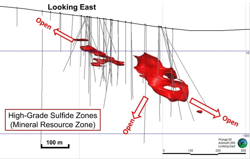
Figure 1. A long-section view of the sulfide zone (looking east). As indicated, the resource is open to the north, south (subject to a cross-cutting fault), and southwest. Source: Western Alaska Minerals
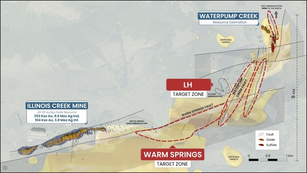
Western Alaska Minerals (TSXV:WAM) has announced an initial mineral resource estimate for the Waterpump Creek Zone at its 100% owned Illinois Creek project located in western Alaska.
The mineral resource estimate includes indicated resources of 1.96 million tonnes at 516 g/t silver, 5.8% lead and 14.6% zinc. Inferred resources are 0.43 million tonnes at 508 g/t silver, 6.2% lead and 13.1% zinc.
CEO Kit Marrs commented in a press release: “We believe we have a tiger by the tail at Illinois Creek and decided to proceed with an inferred resource estimate to demonstrate to the market the robust high grade (and high margin potential) of the WPC deposit as we’ve carried it from discovery to a significant volume of high-grade mineralization. This resource says we’re moving in the right direction and we’re looking forward to following the mineralization 7.5 km to the southwest back towards the past-producing Illinois Creek mine. We are in the early stages of developing a robust portfolio of base and precious minerals crucial for various industries. Silver, with its vital role in solar production and numerous industrial applications, and zinc, recognized as a critical mineral in the energy transition, defence, and agriculture sectors, are pivotal in driving the clean energy transition. Waterpump Creek, hosting a high-grade resource, significantly contributes to our sustainable future aspirations. This highlights our commitment to sustainable exploration practices and underscores the immense potential ahead for us at WAM.”
The resource estimate was prepared by independent qualified persons Dr. Bruce Davis and Susan Lomas of Lions Gate Geological Consulting Inc. It is based on historical and recent drill results totalling over 16,000 metres in 87 holes completed between 1983 and 2023.
The estimate uses a base case cut-off grade of 200 g/t silver equivalent considering metal prices of $24/oz silver, $1/lb lead and $1.30/lb zinc. It covers three sulfide zones at the Waterpump Creek prospect which is interpreted as the distal extension of the over 7.5 km long Illinois Creek carbonate replacement deposit system.
The company states the resource estimate will justify further exploration in the area to expand resources. Additional exploration targets have been defined along the interpreted extensions of the mineralized structures.
The full National Instrument 43-101 technical report for the mineral resource estimate will be filed within 45 days. Western Alaska Minerals says the estimate represents a cornerstone for potential development and expansion of resources across the broader Illinois Creek district.
- 2.39Mt @ 977 g/t silver equivalent (“AgEq”) for 75.0 Moz AgEq . The zinc equivalent is 26.32% ZnEq.
- Attractive mining thicknesses ranging from 5 to 49 meters and widths ranging from 25 to 70 meters over a strike length of 495 meters.
- All-in discovery rate of 3198 AgEq ozs/meter drilled.
- Robust resource that is relatively insensitive up to a cut-off grade up to 600 g/t AgEq.
- Significant zinc component adds important critical minerals potential.
Table 1. Waterpump Creek Sulfide Zone Inferred Mineral Resource Summary (200 g/t AgEq cut-off)
| Sulfide Inferred Resources – Waterpump Creek Resource Area | ||||||||||||
| Class | Tonnes (M) | Average Grade | Contained Metal | |||||||||
| AgEq (g/t) | AgEq (oz/t) | Ag (g/t) | Pb (%) | Zn (%) | ZnEq (%) | AgEq (Moz) | Ag (Moz) | Pb (Mlbs) | Zn (Mlbs) | ZnEq (Mlbs) | ||
| Inferred | 2.39 | 977 | 31.4 | 279 | 9.84 | 11.25 | 26.32 | 75.0 | 21.4 | 518 | 592 | 1384 |
- The effective date of the Mineral Resource is February 20, 2024. The QPs for the Mineral Resource are Dr. Bruce Davis FAusIMM and Susan Lomas, P. Geo of Lions Gate Geological Consulting Inc (LGGC).
- CIM Definition Standards were used for mineral resource classification and in accordance with CIM MRMR Best Practice Guidelines. Mineral Resources are not Mineral Reserves and do not have demonstrated economic viability. It is reasonably expected that the majority of the Inferred Mineral Resources could be upgraded to Indicated Mineral Resources with continued exploration.
- AgEq reporting cut-off grade calculation is based on estimated recoveries from preliminary metallurgical test work of 75% Ag, 70% Pb, and 84% Zn and metal prices of US$24.00/oz Ag, US$1.00/lb Pb, and US$1.30/lb Zn and cost inputs suitable for underground extraction method.
- The AgEq and ZnEq grade calculations used in the table above are based on the same metal prices (as point #3 above) and are not subject to recovery.
- This Initial Inferred Mineral Resource Estimate is merely a beginning and demonstrates the high-grade nature of the mineralized system and that more exploration is fully warranted.
- High-Grade: The resource silver equivalent grade compares well with the most successful high grade silver projects in production or development over the last decade including Silver Crest (Las Chispas), MAG Silver (Juanicipio), Adriatic (Vares), and now Vizsla Silver (Copala).
- Under-Drilled: Substantial discovery rate in just 23,450 meters of drilling (15,550 meters of drilling was completed by WAM and 7,900 meters was completed by Anaconda and NovaGold).
- Expansion Potential: The 2023 WAM 3D IP survey results demonstrate significant exploration potential both immediately north of WPC resource and south along the 7.5 km LH trend. In addition, the geophysics support a major new target, the Warm Springs target, which further connects the WPC/LH trend with the historic Illinois Creek mine gossan oxide Au/Ag deposit.
- Existing NI 43-101 compliant Au-Ag oxide resource estimate: The past-producing Illinois Creek oxide Au-Ag mine, located approximately 7.5 km to the SE of WPC has an indicated estimate of 253 Koz Au, 9.5Moz Ag and an inferred estimate of 104Koz Au, 3.8Moz Ag.
Table 2. Sensitivity table showing Waterpump Creek Sulfide Inferred Resources at various AgEq cut-off grades.
| Sulfide Inferred Resources – Waterpump Creek Resource Area | ||||||||||||
| Cut off (AgEq g/t) | Tonnes (M) | Average Grade | Contained Metal | |||||||||
| AgEq (g/t) | AgEq (oz/t) | Ag (g/t) | Pb (%) | Zn (%) | ZnEq (%) | AgEq (Moz) | Ag (Moz) | Pb (Mlbs) | Zn (Mlbs) | ZnEq (Mlbs) | ||
| 0 | 2.39 | 976 | 31.4 | 278 | 9.83 | 11.24 | 26.3 | 75.0 | 21.4 | 518 | 592 | 1385 |
| 100 | 2.39 | 976 | 31.4 | 278 | 9.83 | 11.24 | 26.3 | 75.0 | 21.4 | 518 | 592 | 1385 |
| 150 | 2.39 | 976 | 31.4 | 278 | 9.83 | 11.24 | 26.3 | 75.0 | 21.4 | 518 | 592 | 1385 |
| 200 | 2.39 | 977 | 31.4 | 279 | 9.84 | 11.25 | 26.3 | 75.0 | 21.4 | 518 | 592 | 1384 |
| 250 | 2.38 | 980 | 31.5 | 279 | 9.86 | 11.27 | 26.4 | 74.9 | 21.4 | 517 | 591 | 1383 |
| 300 | 2.37 | 982 | 31.6 | 280 | 9.89 | 11.30 | 26.4 | 74.9 | 21.4 | 517 | 591 | 1382 |
| 400 | 2.33 | 993 | 31.9 | 284 | 10.02 | 11.40 | 26.7 | 74.4 | 21.3 | 515 | 585 | 1373 |
| 500 | 2.27 | 1007 | 32.4 | 288 | 10.20 | 11.51 | 27.1 | 73.5 | 21.1 | 511 | 576 | 1357 |
| 600 | 2.20 | 1021 | 32.8 | 293 | 10.37 | 11.63 | 27.5 | 72.3 | 20.7 | 504 | 565 | 1335 |
| 800 | 2.01 | 1051 | 33.8 | 303 | 10.78 | 11.87 | 28.3 | 67.8 | 19.5 | 477 | 525 | 1252 |
| 1000 | 1.36 | 1113 | 35.8 | 320 | 11.46 | 12.54 | 30.0 | 48.5 | 13.9 | 343 | 375 | 896 |
The above references an opinion and is for information purposes only. It is not intended to be investment advice. Seek a licensed professional for investment advice. The author is not an insider or shareholder of any of the companies mentioned above.
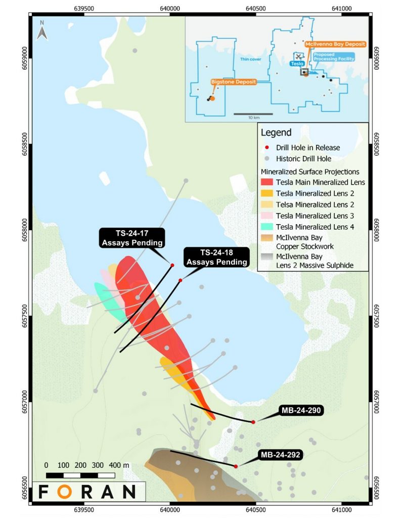
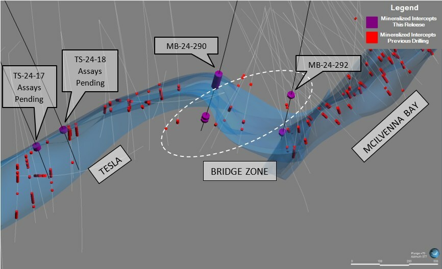
Foran Mining (TSX:FOM) has reported initial assay results from the 2024 winter drilling program at the Tesla and Bridge Zones, which are part of the company’s 100% owned McIlvenna Bay Project in Saskatchewan. The initial results from recent Tesla Zone drilling continue to confirm the continuity of mineralization along strike, currently up to 1,050 meters, beyond the limits of the modeled conductor.
Erin Carswell, Foran’s Vice President, Exploration, commented in a press release: “The 2024 Winter drill program has started on an exceptionally positive note, with results from hole MB-24-290 representing a significant strike extension of the Tesla Zone. Now measuring over one kilometre long and extending beyond the original EM target length, Tesla is rapidly expanding beyond our expectations as a zone of strategic importance for future growth initiatives. Additionally, two new up-dip intersections have extended Tesla towards surface confirming the potential for shallower mineralization, with assays from these latter intervals expected shortly. Of particular interest, the southernmost Bridge Zone intercept encountered elevated gold mineralization when compared to McIlvenna Bay reserve grades, highlighting the possibility of growing precious metal credits. We are looking forward to maintaining this momentum and provide updates on our developments from Tesla and the Bridge Zone as the important ice drilling season unfolds”.
The winter drill program began on January 11, 2024 with six drill rigs currently active. Four drills are focused on expanding the main Tesla Zone with step-out drilling along strike, up-dip and down-dip, while the remaining two drills are focused on definition drilling of the Bridge Zone. Foran plans to complete up to 20,000 meters of drilling during this winter program, with initial assay results from the first two holes reported here.
The Tesla Zone, discovered in 2022, lies adjacent to and approximately 300 meters north of the McIlvenna Bay Deposit. Since discovery, the Tesla Zone has been successfully intersected by 20 drill holes defining mineralization over a 1,050 meter strike length and 500 meters of dip extent. These holes have intersected multiple massive and semi-massive copper and zinc mineralized horizons and associated stringer zones that remain open in all directions.
The Bridge Zone occurs in a ~300 meter corridor between the current southernmost drilling at Tesla and the northernmost drilling at McIlvenna Bay. Discovered in 2023 and confirmed with three drill holes, the Bridge Zone typically contains multiple lenses of massive, semi-massive and stringer style sulfide mineralization. Detailed core observations and results from the ongoing McIlvenna Bay Orebody Knowledge Study have identified important geological markers within the Bridge Zone that link the two areas. This suggests a post-mineralization fold connects Tesla and McIlvenna Bay. Mineralization in the Bridge Zone appears to correlate with ore zones in the McIlvenna Bay Deposit.
The recently completed holes TS-24-17 and TS-24-18 targeted Tesla’s up-dip expansion potential from known mineralized zones. While assays are pending, logging, XRF and EM data confirm successful intersections of the main Tesla Zone horizon an average of ~160 meters up-dip from existing mineralized intersections in the central Tesla Zone. Significantly, EM surveys indicate mineralization continues at least 50-75 meters further up-dip and 200 meters along strike, providing a robust target model.
TS-24-17 intersected mineralization related to the main Tesla Zone approximately 179 meters updip from a 7.1 meter intersection grading 3.51% CuEq from 2023 drilling. TS-24-18, 100 meters southeast, also intersected massive and semi-massive sulfides with stringer zones related to Tesla, 171 meters updip from a 2023 intersection grading 4.11% CuEq over 34.3 meters. The success of these shallower holes has prompted more intensive updip exploration planning utilizing navigational drilling for the 2024 summer program. Historic northern McIlvenna Bay drilling, which intersected shallow copper outside current resources, will also be reviewed.
The current winter drill program is focused on Tesla and the Bridge Zone with two main strategies:
- Continue assessing Tesla through wide-spaced step-outs to expand known mineralization along strike and up/down dip, increasing definition of known horizons.
- Target Bridge Zone connections with Tesla and McIlvenna Bay to understand stratigraphic/structural relationships, fold/fault geometry and potential for upgrading mineralization in structural traps.
Drilling continues with six rigs. To date, ten holes plus one wedge have been completed encompassing 11,900 meters. Two rigs target the Bridge Zone, while four focus on Tesla step-outs. The ice-based program is anticipated to run until early April 2024, subject to ice conditions.
Following ice-based drilling, work will transition to land-based collars to continue Tesla Zone definition through summer. Several twinned wedges are also planned to provide mineralized material for early metallurgical testing. Expansion drilling will continue to focus on the target areas shown in the accompanying figure.
Foran will report further assay results from the winter program as they become available over the coming weeks. The success of the initial holes, particularly the Tesla Zone intersections and updip extensions, continues to demonstrate the potential for significant expansion of the deposit. The company remains well-funded to advance this large-scale exploration and development project.
Highlights from the results are as follows:
- Drilling at Tesla encountered thick zones of mineralization, with the uppermost zone representing a 140m strike extension of the Tesla Zone to the southeast, expanding the strike length of Tesla to 1,050m. Highlight intercepts from MB-24-290:
- 27.4m grading 1.03% Cu, 2.17% Zn, 28.3 g/t Ag and 0.20 g/t Au (1.83% CuEq), including 8.3m grading 1.28% Cu, 3.62% Zn, 35.7 g/t Ag and 0.03 g/t Au (2.43% CuEq).
- Mineralization has now extended beyond the original bounds of the 900m-long surface Electro-Magnetic (“EM”) conductor target.
- Assays for lower zone are pending.
- Drilling at the transition zone between the McIlvenna Bay Deposit and the Bridge Zone intersected two mineralized intervals, highlights from MB-24-292 below include elevated gold intercepts:
- 8.5m grading 1.56% Cu, 2.05% Zn, 24.3 g/t Ag and 0.65 g/t Au (2.52% CuEq), including 2.6m grading 0.85% Cu, 2.64% Zn, 19.5 g/t Ag and 1.59 g/t Au (2.58% CuEq).
- Assays for the lower zone are pending.
- Assays are also pending from two drillholes targeting Tesla up-dip extensions which intersected significant thicknesses of mineralization located approximately 160m up-dip of previously drilled mineralization, indicating a total up/down dip extent for the Tesla Zone of at least 500m in this location. Subsequent borehole EM surveys on these holes indicate that mineralization likely continues at least 50-75m further up-dip and at least 200m along strike in the up-plunge direction in the central part of Tesla.
- Tesla remains open in all directions for expansion and increased understanding of the zone is the focus of the current program.
Table 1 – 2024 Winter Bridge Zone Assay Results1
|
Hole |
Zone |
From_m |
To_m |
Interval_m |
Cu % |
Zn % |
Ag g/t |
Au g/t |
CuEq % |
|
MB-24-290 |
MS/CS |
1021.8 |
1049.1 |
27.4 |
1.03 |
2.17 |
28.3 |
0.20 |
1.83 |
|
Including |
MS |
1021.8 |
1030.1 |
8.3 |
1.28 |
3.62 |
35.7 |
0.03 |
2.43 |
|
And |
CS |
1030.1 |
1049.1 |
19.0 |
0.91 |
1.54 |
25.0 |
0.27 |
1.56 |
|
MB-24-290 |
CS |
1050.8 |
1098.3 |
47.5 |
0.50 |
0.65 |
9.5 |
0.05 |
0.72 |
|
MB-24-290 |
CS |
1103.8 |
1105.2 |
1.42 |
3.06 |
0.16 |
21.4 |
0.01 |
2.94 |
|
MB-24-292 |
MS |
871.6 |
880.0 |
8.5 |
1.56 |
2.05 |
24.3 |
0.65 |
2.52 |
|
Including |
MS |
871.6 |
874.2 |
2.6 |
0.85 |
2.64 |
19.5 |
1.59 |
2.58 |
|
And |
MS |
878.1 |
880.0 |
2.0 |
2.33 |
1.14 |
38.6 |
0.47 |
2.91 |
|
Note 1: Composite widths are presented as core lengths. Additional drilling will be required to confirm the geometry of the mineralized zones, but generally true widths are thought to be 80-85% of core length. Intervals generally composited using a 0.5% Cu cut-off grade in stringer zones, except MB-24-290 from 1050.8-1098.3m that used a 0.3% Cu cut-off grade. Copper Equivalent values calculated using metal prices of $4.00/lb Cu, $1.50/lb Zn, $20.00/ounce Ag and $1,800/ounce Au and LOM metallurgical recovery rates derived from test work on blended ores for the McIlvenna Bay Deposit completed as part of our April 2022 Feasibility Study: 91.1% Cu, 79.8% Zn, 88.6% Au and 62.3% Ag (MS – massive / semi-massive sulphide, CS – Copper Stockwork/Stringer). To date no metallurgical test work has been completed on the Tesla Zone or Bridge Zone mineralization. |
Table 2 – 2021 Historic Assay Results from MB-21-244a1
|
Hole |
From_m |
To_m |
Interval_m |
Cu % |
Zn % |
Ag g/t |
Au g/t |
|
MB-21-244a |
107.5 |
114.8 |
7.3 |
1.79 |
0.01 |
0.12 |
0.00 |
|
Including |
110.2 |
111.5 |
1.4 |
4.28 |
0.01 |
0.17 |
0.01 |
|
Note 1: Composite widths are presented as core lengths. Additional drilling will be required to confirm the geometry of the mineralized zones, but generally true widths are thought to be 80-85% of core length. Intervals generally composited using a 0.5% Cu cut-off grade in stringer zones. |
The above references an opinion and is for information purposes only. It is not intended to be investment advice. Seek a licensed professional for investment advice. The author is not an insider or shareholder of any of the companies mentioned above.

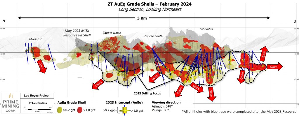
Prime Mining (TSX:PRYM) provided an update this week summarizing the highlights of its 2023 drill program at the company’s wholly-owned Los Reyes Gold-Silver Project in Sinaloa State, Mexico. The past year of drilling has continued to demonstrate the potential for resource expansion across multiple areas of the expansive project.
Scott Hicks, CEO of Prime, commented in a press release: “2023 was a standout year for Prime. In addition to other corporate and technical achievements, we effectively doubled the gold-equivalent resource ounces at our high-grade Los Reyes Project with drilling up to our December 2022 resource drilling cutoff. In 2023 we completed almost 60,000 metres of drilling, and we are excited to recap this 2023 exploration work today, as well as releasing notable new generative area intercepts at Mina, Orito Sur and Mariposa. Our 2024 drill program is already underway at Las Primas, Z-T and Guadalupe, and we are starting to see some exciting results from this initial 40,000-metre program come in. As in previous years, we will revisit this program as we continue to achieve our exploration goals for the Company and are looking forward to sharing results with our stakeholders along the way.”
Along the Z-T Trend, drilling intercepted wide, high-grade zones that support enlarging the gold-equivalent grade shell used for resource modeling. One standout hole was along the newly discovered “300 Trend” structure, returning 7.12 g/t gold equivalent over 2.1 meters estimated true width. The 300 Trend structure splays off the main Zapote trend and consists of gold and silver bearing quartz and breccia over approximately 2 kilometers. Prime tested an 800-meter section in 2023, hitting mineralization in all 11 widely spaced holes drilled to 250 meters depth.
In addition to the 300 Trend discovery, high-grade plunging shoots remain open at depth and along multiple kilometers of strike length unexplored by drilling. Surface mapping indicates the Z-T structure has over 4 kilometers of prospective strike. Expanding these plunging shoots is a key target for Prime’s 2023 exploration.
At the Tahonitas area, part of the Z-T Trend, drilling successfully extended silver-rich mineralization 350 meters to the southeast of previous drilling.
Along the Guadalupe Trend, exploration results hold the potential to significantly expand resources in the Guadalupe East zone. One standout hole, 23GE-147, returned 45.3 g/t gold and 2,723 g/t silver over 3.9 meters estimated true width. This very high-grade intercept expands mineralization along several structures within the current resource pit at Guadalupe East. 2023 drilling also expanded the overall resource grade shell by 370 meters to the southeast. Mineralization remains open along strike and at depth, presenting a compelling target for expansion drilling in 2023.
In the Central Trend, drilling expanded near-surface, open-pit amenable mineralization by over 150 meters southeast along strike from current modeling at the Noche Buena zone. Drilling also revealed a substantial volume of previously untested, high-grade material in the gap between the Noche Buena and San Miguel East resource pits. Filling in these areas to connect the two pits will be a focus for 2023 drilling.
Beyond expanding current resource areas, Prime had success with generative exploration drilling at several new target areas in 2023. These early-stage zones demonstrate significant high-grade potential outside of current resources.
Las Primas, situated between the Guadalupe and Central trends, contains multiple newly discovered high-grade plunging shoots analogous to mineralization at Guadalupe East. Early modeling at Las Primas suggests continuity over 450 meters strike length and 300 meters vertical depth. The area remains open in all directions after the initial round of 2023 drilling.
At Fresnillo, another new discovery located between the main Z-T and Central trends, 2023 drilling intercepted thick intervals of precious metals mineralization outside of current resource areas. Surface mapping and modeling are ongoing to guide follow-up drilling in 2024.
For 2024 exploration, Prime has laid out plans for 40,000 meters of drilling utilizing six active rigs on site. Efforts will remain focused on expanding high-grade resources at depth and along strike, while also testing early-stage targets to unlock the district-scale potential of the Los Reyes property. With success in 2023 exploration drilling, Prime continues systematically advancing Los Reyes toward development while also proving out major resource growth opportunities across multiple zones.
2023 Corporate Highlights
Advanced project investigations:
- Released Mineral Resource Estimate (“MRE”) on May 2, 2023, based on year end 2022 drilling, outlining:
- 1.47 million Indicated gold-equivalent (“AuEq”) ounces at a 1.68 grams per tonne (“gpt”) average grade, comprised of 1.0 million ounces of gold at 1.16 gpt and 35 million ounces of silver at 40.4 gpt.
- 0.73 million Inferred AuEq ounces at a 1.26 gpt average grade, comprised of 0.5 million ounces of gold at 0.85 gpt and 18.4 million ounces of silver at 31.5 gpt.
- Completed 58,896 metres (“m”) of drilling over 184 holes following success-based exploration program; 162 drill holes intercepted mineralization above approximately 0.2 gpt Au cutoff.
- Expanded high-grade mineralization at Z-T by 350 m along strike and multiple high-grade shoots by several hundred metres down dip.
- Grew the mineralized grade shells at Central and Guadalupe Trends, where we have discovered several new high-grade antithetic veins.
- Continued to develop generative targets, with particular success at Las Primas, as well as several other zones including Fresnillo, Mina, Mariposa and the 300 Trend.
- Advanced our metallurgical, geochemical, geotechnical and project understanding through testwork and field studies.
Strengthened Management Team and Board:
- Appointed Indi Gopinathan as VP Capital Markets and Business Development in April 2023.
- Appointed Advisor Kerry Sparkes to Board of Directors in August 2023.
- Completed internal management transition in late 2023, culminating in January 2024 appointment of Scott Hicks as CEO.
Ended year in strong financial position:
- Held approximately C$33 million in cash at December 31, following receipt of C$28 million from successful warrant acceleration program in May 2023.
Demonstrated commitment to Environment, Social and Corporate Governance:
- Released inaugural ESG report in April 2023.
- Social and community engagement activities, including agreement to double active work areas.
- Graduated from the TSX Venture Exchange to the TSX main board.
Z-T Drill Highlights – Additional New Discovery Strike Extent Down Dip and Below MRE:
- 6.19 gpt AuEq (3.33 gpt Au and 220.9 gpt Ag) over 11.6 m etw in hole 23TA-64 in Tahonitas, including:
- 41.92 gpt AuEq (24.0 gpt Au and 1,385.0 gpt Ag) over 1.0 m etw.
- 4.86 gpt AuEq (3.80 gpt Au and 82.0 gpt Ag) over 13.3 m etw in hole 23TA-69, located 100 m below the MRE resource pit, including:
- 9.30 gpt AuEq (8.15 gpt Au and 89.2 gpt Ag) over 3.7 m etw.
- 3.87 gpt AuEq (3.16 gpt Au and 54.9 gpt Ag) over 20.5 m etw in hole 23TA-71, located 220 m down dip and below the MRE resource pit, including:
- 8.72 gpt AuEq (7.63 gpt Au and 84.0 gpt Ag) over 5.5 m etw.
- 2.09 gpt AuEq (1.26 gpt Au and 63.9 gpt Ag) over 11.6 m etw in hole 23TA-90, including:
- 3.83 gpt AuEq (2.61 gpt Au and 94.5 gpt Ag) over 2.2 m etw.
Significant SE Strike Extension Potential at Tahonitas:
- 3.74 gpt AuEq (0.99 gpt Au and 212.5 gpt Ag) over 5.7 m etw in hole 23TA-100, located 350m along strike to the SE from the MRE pit crest, including:
- 10.94 gpt AuEq (2.97 gpt Au and 616.0 gpt Ag) over 1.3 m etw.
- 2.33 gpt AuEq (0.83 gpt Au and 115.9 gpt Ag) over 7.1 m etw in hole 23TA-91, located 150m along strike to the SE from the MRE pit crest.
Mariposa, a generative target northwest of Z-T, returned strong gold grades:
- 3.3 gpt AuEq (3.11 gpt Au and 14.8 gpt Ag) over 2.2 m etw downhole in new hole 23MA-11*
Guadalupe East – High Grade Gold and Silver
- 13.51 gpt AuEq (10.10 gpt Au and 263.8 gpt Ag) over 2.2 m etw in hole 23GE-142 at Guadalupe East, including:
- 23.46 gpt AuEq (17.80 gpt Au and 437.0 gpt Ag) over 1.2 m etw; and,
- 44.39 gpt AuEq (18.20 gpt Au and 2,024.0 gpt Ag) over 1.0 m etw
- 15.06 gpt AuEq (5.46 gpt Au and 742.0 gpt Ag) over 0.8 m etw in hole 23GE-136.
- 17.95 gpt AuEq (9.69 gpt Au and 638.55 gpt Ag) over 31.25 m etw in hole 23GE-147, including;
- 52.67 gpt AuEq (29.41 gpt Au and 1,797.3 gpt Ag) over 6.45 m etw, and including,
- 80.57 gpt AuEq (45.34 gpt Au and 2,722.6 gpt Ag) over 3.90 m etw.
- 27.56 gpt AuEq (8.17 gpt Au and 1,498.0 gpt Ag) over 0.6 m etw in new hole 23GE-144*
Orito Sur, a generative target north of Guadalupe East, returned strong gold and silver grades:
- 5.3 gpt AuEq (2.70 gpt Au and 200.5 gpt Ag) over 2.4 m etw in new hole 23OS-01*
Mina, a generative target northeast of Guadalupe East, also returned strong grades:
- 4.24 gpt AuEq (2.54 gpt Au and 131.3 gpt Ag) over 4.9 m downhole in new hole 23MINA-13*
Central – High Grade, Near-Surface Material at Noche Buena
- 4.99 gpt AuEq (4.11 gpt Au and 67.9 gpt Ag) over 9.1 m etw in hole 23NB-46, located 150 m along strike from the bottom of the MRE pit, including:
- 37.48 gpt AuEq (31.40 gpt Au and 470.0 gpt Ag) over 1.1 m etw.
- 1.50 gpt AuEq (1.23 gpt Au and 20.5 gpt Ag) over 14.0 m etw in hole 23NB-39, located immediately adjacent to the MRE pit, including:
- 5.17 gpt AuEq (4.19 gpt Au and 76.0 gpt Ag) over 2.0 m etw.
- 2.43 gpt AuEq (0.91 gpt Au and 117.3 gpt Ag) over 6.5 m etw in new hole 23NB-59*
Noche Buena and San Miguel East – Drilling to Fill the Gap Returns Strong Silver Values
- 4.49 gpt AuEq (1.48 gpt Au and 232.6 gpt Ag) over 5.0 m etw in hole 23NB-51, including:
- 8.00 gpt AuEq (2.70 gpt Au and 409.4 gpt Ag) over 2.6 m etw and;
- 3.51 gpt AuEq (3.36 gpt Au and 11.9 gpt Ag) over 1.2 m etw.
- 3.81 gpt AuEq (1.62 gpt Au and 169.2 gpt Ag) over 2.6 m etw in hole 23NB-53, including:
- 8.21 gpt AuEq (2.77 gpt Au and 420.0 gpt Ag) over 1.0 m etw;
- 1.33 gpt AuEq (0.55 gpt Au and 60.1 gpt Ag) over 4.4 m etw in hole 23SME-37, including:
- 2.65 gpt AuEq (2.03 gpt Au and 48.2 gpt Ag) over 0.7 m etw;
- 2.23 gpt AuEq (0.99 gpt Au and 95.9 gpt Ag) over 1.4 m etw in hole 23SME-34, located on the north-east side of San Miguel East.
Las Primas Area – Prime Discovery:
- 15.63 gpt AuEq (11.60 gpt Au and 311.1 gpt Ag) over 4.5 m etw in hole 23LP-18, including:
- 27.52 gpt AuEq (20.39 gpt Au and 550.8 gpt Ag) over 2.5 m etw, and including,
- 56.28 gpt AuEq (41.90 gpt Au and 1,111.0 gpt Ag) over 1.1 m etw;
- 12.34 gpt AuEq (10.85 gpt Au and 114.9 gpt Ag) over 2.5 m etw in hole 23LP-14 at Las Primas, including:
- 17.50 gpt AuEq (15.40 gpt Au and 162.2 gpt Ag) over 1.7 m etw.
- 1.73 gpt AuEq (1.70 gpt Au and 2.3 gpt Ag) over 9.6 m etw in hole 23LP-06, including:
- 4.94 gpt AuEq (4.88 gpt Au and 4.7 gpt Ag) over 3.0 m etw.
- 1.20 gpt AuEq (0.87 gpt Au and 25.8 gpt Ag) over 14.6 m etw in hole 23LP-07, starting just below surface.
Fresnillo – Prime Original Discovery
- 1.67 gpt AuEq (1.44 gpt Au and 17.6 gpt Ag) over 15.8 m etw in hole 22FRE-09, including:
- 5.36 gpt AuEq (4.73 gpt Au and 48.4 gpt Ag) over 2.9 m etw.
- 1.65 gpt AuEq (1.06 gpt Au and 45.2 gpt Ag) over 10.9 m etw in hole 23FRE-19, including:
- 12.30 gpt AuEq (6.63 gpt Au and 438.0 gpt Ag) over 0.85 m etw.
The above references an opinion and is for information purposes only. It is not intended to be investment advice. Seek a licensed professional for investment advice. The author is not an insider or shareholder of any of the companies mentioned above.
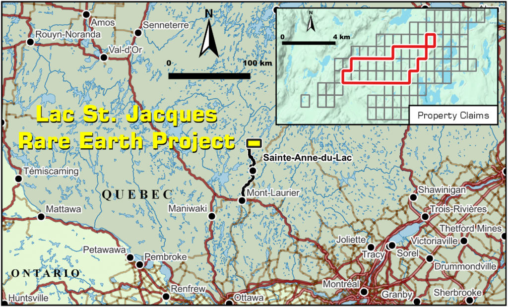
Troy Minerals (TSXV:TROY) has released results from the final two drill holes completed in Fall 2023 at its 100% owned Lac Jacques rare earth element (REE) property. The property is located approximately 250 kilometres north of Montreal, Quebec, Canada.
Rana Vig, President and CEO, commented in a press release: “The final drill holes from the 2023 program returned strongly mineralized broad intervals as well as several narrow bands of anomalous mineralization. These results further cement our confidence in the REE potential at the Lac Jacques Property. Intersecting mineralization away from structures known to control mineralization leads us to believe there are several controls and sources of REE in the area as the footprint of mineralization continues to grow. We are designing our 2024 exploration campaign for Lac Jacques and look forward to sharing those plans with our investors in the coming weeks. The company has a strong treasury position and looks to further build shareholder value through organic growth across our portfolio of prospective projects located in Tier 1 jurisdictions while continuously looking for accretive M&A opportunities.”
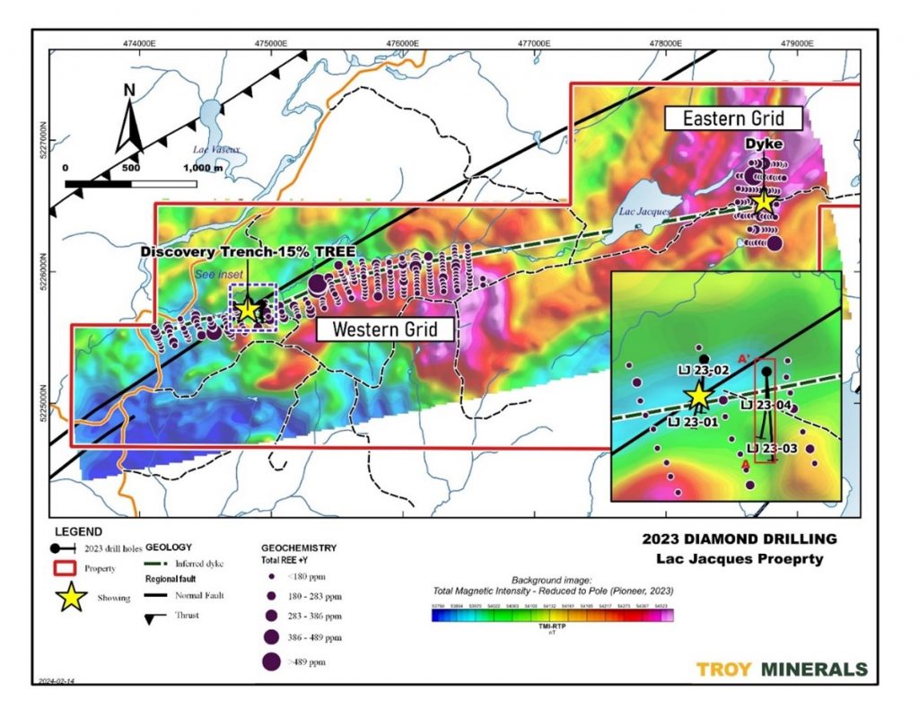
Drill Program Summary
The 2023 drill program at Lac Jacques consisted of four holes designed to test below and along strike of a previously identified discovery trench. Drill holes LJ-23-03 and LJ-23-04 were drilled 100 meters east of the initial holes (LJ-23-01 and -02).
Both LJ-23-03 and LJ-23-04 intersected narrow zones of anomalous rare earth mineralization (>1000 ppm TREO+Y2O) associated with pegmatitic granite and syenite in the upper sections of the holes.
- LJ-23-03: Significant intersections included 2526.1 ppm TREO over 2.90 meters, including 3627.9 ppm TREO over 0.9 meters.
- LJ-23-04: Significant intersections included 1495.9 ppm TREO over 5.40 meters, including 3274.7 ppm TREO over 1.40 meters, and 1615.3 ppm TREO over 4.40 meters, including 3107.9 ppm TREO over 1.00 meter.
Both holes also encountered a section of gabbro with minor pegmatitic syenite xenoliths. A zone of weakly anomalous TREO was associated with the syenite in both holes, suggesting a possible flat-lying mineralization zone.
Overall, the grades in these final holes were lower than those encountered in the initial holes (LJ-23-01 and -02). Additionally, the major fault zone observed in the initial holes was not intersected in the recent drilling.
Analysis of core samples from the initial holes identified various REE-bearing minerals, including allanite, fergusonite, monazite, and unidentified REE-carbonates. Allanite was found to be the primary REE-bearing mineral.
Troy Minerals plans to utilize the data collected from the drill program to identify targets for a winter 2024 drill program anticipated to commence in February or early March.
Highlights from the results are as follows:
- Hole LJ-23-03 intersected 2526.1 ppm TREO over 2.90 metres (m) from 53.0m -55.9m including 3627.9 ppm TREO over 0.9m.
- Hole LJ-23-04 intersected 1495.9 ppm TREO over 5.40m from 54.6m – 60.0m, including 3274.7 ppm TREO over 1.40m and 1615.3 ppm TREO over 4.40m from 72.6m -77.0m including 3107.9 ppm TREO over 1.00 metres.
- Drilling encountered multiple samples of anomalous REE concentrations near surface.
- Results extended the mineralization to the southeast of structures intersected in previous 2 drill holes suggesting the presence of multiple mineralizing events in the area and potentially larger mineralized footprint.
Table 1: Drill hole significant intersections, LJ-23-03, -04 (>1,000 ppm TREO+Y2O3)
| Hole | Interval (m) | Results (ppm) | |||||
| From | To | Length | TREO+Y2O | LREO | HREO | MREO | |
| LJ-23-03 | 34.0 | 35.0 | 1.0 | 1319.4 | 1240.6 | 78.4 | 247.1 |
| 45.2 | 46.0 | 0.8 | 2322.8 | 2195.2 | 126.9 | 428.8 | |
| 53.0 | 55.9 | 2.9 | 2526.7 | 2399.8 | 126.3 | 476.3 | |
| 109.5 | 110.3 | 0.8 | 1039.1 | 831.3 | 207.4 | 183.2 | |
| 114.0 | 115.7 | 1.7 | 1285.3 | 994.0 | 130.7 | 218.8 | |
| 161.0 | 164.0 | 3.0 | 1421.7 | 1298.1 | 123.2 | 272.1 | |
| LJ-23-04 | 19.6 | 20.3 | 0.7 | 1373.3 | 1298.4 | 74.6 | 251.9 |
| 21.5 | 22.5 | 1.0 | 2982.8 | 2872.2 | 109.9 | 531.1 | |
| 31.0 | 32.3 | 1.3 | 1909.1 | 1804.3 | 104.4 | 344.9 | |
| 54.6 | 60.0 | 5.4 | 1496.2 | 1404.0 | 92.1 | 278.9 | |
| 72.6 | 77.0 | 4.4 | 2440.7 | 1478.1 | 137.2 | 292.5 | |
| 219.8 | 220.0 | 0.2 | 1567.6 | 518.6 | 809.6 | 135.3 | |
Note: all intersection lengths are drill-indicated. Insufficient structural data has been obtained to estimate true widths.
LREO: Light rare earth oxides – Sum of concentration of rare earth oxides La2O3, CeO2, Pr6O11, Nd2O3, Sm2O3, Eu2O3
HREO: Heavy rare earth oxides – Sum of concentration of rare earth oxides Gd2O3, Tb4O7, Dy2O3, Ho2O3, Er2O3, Tm2O3, Yb2O3, Lu2O3, Y2O3
MREO: Magnet rare earth oxides Sum of concentration of rare earth oxides Pr6O11 and Nd2O3
TREO: Total rare earth oxides – Sum of LREO and HREO
The above references an opinion and is for information purposes only. It is not intended to be investment advice. Seek a licensed professional for investment advice. The author is not an insider or shareholder of any of the companies mentioned above.
Integra Resources (TSXV:ITR) has announced the second set of drill results from the 2023 highwall geotechnical and metallurgical drill program at the DeLamar Projec in southwestern Idaho. The drill program, which totaled 4,597 meters, was completed in November 2023.
Integra’s President, CEO & Director, Jason Kosec commented in a press release: “The drill results announced today further demonstrate the size, grade, and continuity of the mineral resource at DeLamar. Although the drill program was primarily designed to collect material for heap leach metallurgical testwork and geotechnical studies, we continue to intercept significant mineralized widths at excellent grades throughout the Project, exemplifying the robust nature of DeLamar. The results from this drill program will be used to complete a Feasibility Study at DeLamar in the future and to support on-going permitting work at the Project, following the submission of the MPO to the BLM in December 2023.”
The latest results comprise 20 drill holes representing 2,290 meters. The core samples collected will be used for mineralogical analysis, Crusher Work Index testing, and additional heap leach recovery testwork including bottle roll, permeability and column leach studies. Integra states the metallurgical drilling data will support the development of an advanced geo-metallurgical model to inform future economic assessments for the Project.
Additionally, geotechnical drilling within the proposed DeLamar Project open pits gathered further data to enhance the 3D geotechnical model. This supplementary geotechnical data will also bolster Integra’s recently submitted Draft Mine Plan of Operations to the U.S. Bureau of Land Management in December 2023.
The DeLamar Project comprises the neighboring DeLamar and Florida Mountain gold and silver deposits in Owyhee County, southwest Idaho. Since acquiring the Project in 2017, Integra has significantly expanded the resource size and completed positive economic studies including a Preliminary Economic Assessment and Preliminary Feasibility Study.
-
- DH-FLM-23-MET02: 1.42 g/t grams per tonne (“g/t”) gold (“Au”) and 3.36 g/t silver (“Ag”) (1.46 g/t gold equivalent (“AuEq”)) over 134.11 m, including 103.57 g/t Au and 30.55 g/t Ag (103.96 g/t AuEq) over 1.52 m
- Excluding the high-grade intercept, the residual grade of DH-FLM-23-MET02 is 0.25 g/t Au and 3.05 g/t Ag (0.29 g/t AuEq) over 132.59 m, which is above the cut-off grade of 0.17 g/t AuEq1
- DM-FLM-23-MET09: 0.30 g/t Au and 17.03 g/t Ag (0.52 g/t AuEq) over 139.90 m, including 1.49 g/t Au and 437.00 g/t Ag (7.11 g/t AuEq) over 1.53 m
- Excluding the high-grade intercept, the residual grade of DH-FLM-23-MET09 is 0.29 g/t Au and 12.39 g/t Ag (0.45 g/t AuEq) over 138.37 m, which is above the cut-off grade of 0.17 g/t AuEq1
- DH-FLM-23-MET12: 0.35 g/t Au and 2.22 g/t Ag (0.38 g/t AuEq) over 80.47 m
- DH-FLM-23-MET15: 0.28 g/t Au and 3.58 g/t Ag (0.32 g/t AuEq) over 189.89 m
- DH-FLM-23-MET02: 1.42 g/t grams per tonne (“g/t”) gold (“Au”) and 3.36 g/t silver (“Ag”) (1.46 g/t gold equivalent (“AuEq”)) over 134.11 m, including 103.57 g/t Au and 30.55 g/t Ag (103.96 g/t AuEq) over 1.52 m
- The latest drilling highlights from the DeLamar Deposit include:
- DH-DLM-23-MET23: 0.27 g/t Au and 7.12 g/t Ag (0.36 g/t AuEq) over 84.89 m
- DH-DLM-23-MET24: 0.74 g/t Au and 115.94 g/t Ag (2.24 g/t AuEq) over 49.99 m, including 1.47 g/t Au and 263.48 g/t Ag (4.87 g/t AuEq) over 15.24 m
- Excluding the high-grade intercept, the residual grade of DH-DLM-23-MET24 is 0.42 g/t Au and 51.23 g/t Ag (1.08 g/t AuEq) over 34.75 m, which is above the cut-off grade of 0.17 g/t AuEq1
- DH-DLM-23-MET33: 0.27 g/t Au and 24.90 g/t Ag (0.59 g/t AuEq) over 52.73 m
- DH-DLM-23-MET38: 0.45 g/t Au and 14.33 g/t Ag (0.64 g/t AuEq) over 74.98 m
|
Drill Hole |
From |
To |
Interval |
g/t Au |
g/t Ag |
g/t AuEq |
|
DH-FLM-23-MET02 |
14.33 |
148.44 |
134.11 |
1.42 |
3.36 |
1.46 |
|
including |
102.72 |
104.24 |
1.52 |
103.57 |
30.55 |
103.96 |
|
DH-FLM-23-MET05 |
0.00 |
111.25 |
111.25 |
0.13 |
18.36 |
0.36 |
|
DH-FLM-23-MET07 |
52.12 |
144.93 |
92.81 |
0.21 |
4.92 |
0.27 |
|
DH-FLM-23-MET09 |
0.00 |
139.90 |
139.90 |
0.30 |
17.03 |
0.52 |
|
including |
47.24 |
48.77 |
1.53 |
1.49 |
437.00 |
7.11 |
|
DH-FLM-23-MET11 |
0.00 |
130.15 |
130.15 |
0.22 |
7.17 |
0.31 |
|
DH-FLM-23-MET12 |
5.79 |
86.26 |
80.47 |
0.35 |
2.22 |
0.38 |
|
DH-FLM-23-MET14 |
63.40 |
120.09 |
56.69 |
0.34 |
7.21 |
0.43 |
|
DH-FLM-23-MET15 |
0.00 |
189.89 |
189.89 |
0.28 |
3.58 |
0.32 |
|
(1) |
Downhole thickness is true thickness. |
|
(2) |
Intervals reported are uncapped. |
|
(3) |
AuEq = g/t Au + (g/t Ag ÷ 77.70). Rounding may cause minor discrepancies in the AuEq column. |
|
(4) |
Certain intervals were not sampled because they were utilized for alternative purposes requiring intact core (i.e. – geotechnical analysis, additional metallurgical tests). These unsampled intervals (~1% of the total program footage) have been replaced by ‘zero grade’ for the purposes of this news release. |
The following table highlights selected intercepts from the 2023 DeLamar Deposit drill program announced today1,2,3,4:
|
Drill Hole |
From |
To |
Interval |
g/t Au |
g/t Ag |
g/t AuEq |
|
DH-DLM-23-MET23 |
0.00 |
84.89 |
84.89 |
0.27 |
7.12 |
0.36 |
|
DH-DLM-23-MET23 |
116.43 |
145.09 |
28.66 |
0.39 |
5.77 |
0.47 |
|
DH-DLM-23-MET24 |
0.00 |
49.99 |
49.99 |
0.74 |
115.94 |
2.24 |
|
including |
17.37 |
32.61 |
15.24 |
1.47 |
263.48 |
4.87 |
|
DH-DLM-23-MET29 |
20.73 |
39.81 |
19.08 |
0.13 |
13.52 |
0.30 |
|
DH-DLM-23-MET29 |
57.30 |
160.02 |
102.72 |
0.12 |
18.31 |
0.35 |
|
DH-DLM-23-MET31 |
67.67 |
112.47 |
44.80 |
0.33 |
21.83 |
0.61 |
|
DH-DLM-23-MET33 |
0.00 |
52.73 |
52.73 |
0.27 |
24.90 |
0.59 |
|
DH-DLM-23-MET34 |
2.44 |
58.83 |
56.39 |
0.14 |
16.87 |
0.36 |
|
DH-DLM-23-MET35 |
16.15 |
80.16 |
64.01 |
0.21 |
9.51 |
0.33 |
|
DH-DLM-23-MET36 |
0.00 |
110.64 |
110.64 |
0.20 |
11.41 |
0.34 |
|
DH-DLM-23-MET37 |
0.00 |
74.98 |
74.98 |
0.16 |
15.57 |
0.36 |
|
DH-DLM-23-MET38 |
0.00 |
74.98 |
74.98 |
0.45 |
14.33 |
0.64 |
|
DH-DLM-23-MET41 |
0.00 |
45.72 |
45.72 |
0.20 |
3.74 |
0.25 |
|
DM23-MET-P8 |
0.00 |
47.24 |
47.24 |
0.36 |
17.76 |
0.59 |
|
(1) |
Downhole thickness is true thickness. |
|
(2) |
Intervals reported are uncapped. |
|
(3) |
AuEq = g/t Au + (g/t Ag ÷ 77.70). Rounding may cause minor discrepancies in the AuEq column. |
|
(4) |
Certain intervals were not sampled because they were utilized for alternative purposes requiring intact core (i.e. – geotechnical analysis, additional metallurgical tests). These unsampled intervals (~1% of the total program footage) have been replaced by ‘zero grade’ for the purposes of this news release. |
The above references an opinion and is for information purposes only. It is not intended to be investment advice. Seek a licensed professional for investment advice. The author is not an insider or shareholder of any of the companies mentioned above.
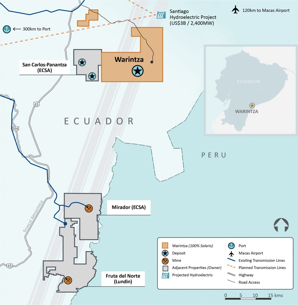
Solaris Resources (TSX:SLS) is preparing for a significant update to its mineral resource estimate for its flagship Warintza Project in southeastern Ecuador. The announcement, made in early January, comes in the middle of an ongoing drilling program and broader developments aimed at advancing the project towards potential development. What’s next for the project, and what are investors waiting for in 2024?
Mineral Resource Estimate Update in Sight
Investors and stakeholders are now waiting for the updated mineral resource estimate, expected in late Q2 2024. This revision will leverage nearly double the drilling data compared to the previous estimate, potentially leading to substantial growth in resource size and grade. The focus areas include Warintza Central, East, and Southeast, where drilling has targeted resource expansion and infill drilling.
A key aspect of the update is the incorporation of a “common pit shell,” which considers the economic viability of extracting all resources within a defined open pit. This approach provides a more realistic picture of the potentially mineable portion of the deposit and is will be critical for future development planning.
Active Drilling Campaign
Solaris is currently executing an ambitious drilling program for 2024, utilizing six drill rigs. This program serves a dual purpose:
- Resource expansion and infill drilling: This component directly supports the upcoming mineral resource estimate update by gathering additional data to refine geological understanding and resource definition.
- Exploration beyond the current resource: Drilling extends outwards from known zones, targeting areas with promising indications of copper mineralization. This proactive approach aims to identify new zones that could contribute to further resource growth in the future.
Beyond Warintza Central, exploration efforts are ongoing in other prospective areas within the project’s broader footprint. These regional activities add another layer to the ongoing exploration story at Warintza.
NYSE American Listing and Financial Backing Signal Confidence
In another significant development, Solaris announced plans to list its common shares on the NYSE American stock exchange. This move is expected to broaden the company’s investor base, particularly attracting interest from the U.S. market.
Financially, Solaris secured funding for its 2024 and 2025 exploration and development programs, ensuring continued momentum at Warintza. This financial backing highlights the company’s commitment to advancing the project and realizing its full potential.
The company’s progress at the Warintza Project received a significant boost in January 2024 with a strategic investment of $130 million from Zijin Mining Group Co., Ltd., a major Chinese mining company. This financing agreement provides crucial capital for ongoing exploration and development activities and represents a strong vote of confidence in the project’s potential.
Under the terms of the deal, Zijin acquired approximately 28.5 million common shares of Solaris at a subscription price of $4.55 per share, representing a 14% premium to the market price at the time. This translates to an ownership stake of roughly 15% for Zijin, granting them a seat on the Solaris board of directors.
The importance of this financing is threefold:
- Financial Security: The $130 million injection directly supports the company’s ambitious plans for 2024 and 2025, including the ongoing drilling program, resource estimation update, and potential future studies. This financial security allows Solaris to focus on advancing the project without immediate funding concerns.
- Strategic Partnership: Zijin’s expertise in developing large-scale copper projects offers valuable insights and potential collaboration opportunities for Solaris. This partnership could prove crucial in navigating the complexities of future development stages.
- Market Validation: The significant investment from a major player like Zijin serves as a strong validation of Warintza’s potential. This positive endorsement could attract further interest from investors and stakeholders, broadening the project’s support base.
Overall, the Zijin financing deal represents a critical milestone for Solaris and the Warintza Project and secures the necessary resources for continued progress.
The Warintza Project also holds the potential to bring significant benefits to Ecuador. Responsible development post-exploration could create many more jobs, stimulate the local economy, and generate tax revenue for the government. Solaris has continued to emphasize its commitment to operating in a sustainable and responsible manner, minimizing environmental impact and engaging with local communities.
Looking Ahead: Milestones and Continued Progress Expectations
The release of the updated mineral resource estimate in late Q2 2024 stands as a major milestone for the Warintza Project. This event will provide valuable insights into the project’s size, grade, and economic potential. Depending on the results, further studies such as preliminary economic assessments or feasibility studies could follow, outlining a potential path towards development.
Solaris remains focused on advancing the Warintza Project through ongoing exploration, resource definition, and potential future development activities. With a significant update on the horizon, active drilling underway, and a secured financial position, the world is watching for the next news update.
The above references an opinion and is for information purposes only. It is not intended to be investment advice. Seek a licensed professional for investment advice. The author is not an insider or shareholder of any of the companies mentioned above.
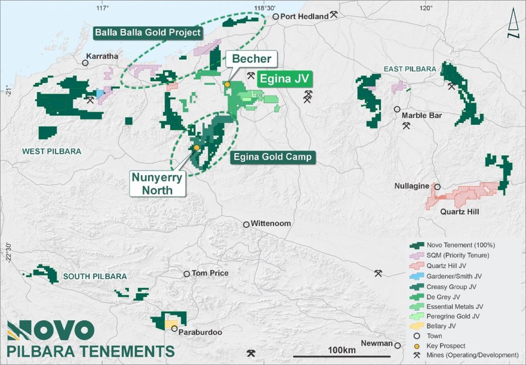
Novo Resources Corp. (ASX:NVO)(TSX: NVO) has provided an update on recent drilling by joint venture partner De Grey Mining (ASX:DEG) at the Becher Project, part of Novo’s highly prospective Egina gold belt in the Pilbara region of Western Australia.
The Becher Project is under an earn-in and joint venture agreement with De Grey, under which De Grey can earn a 50% interest in the project by spending up to A$25 million over four years on exploration.
Novo Executive Co-Chairman and Acting CEO Mike Spreadborough commented in a press release: “This set of results from the recent drilling is very exciting. De Grey has a total of 39,000 m of drilling planned under this program. This ground is going to get some focused exploration attention with De Grey required to spend up to A$25 million at Becher and adjacent tenements within 4 years, to earn a 50% direct interest in the Egina JV. In this programme, a minimum $7 million will be spent within 18 months, so we expect a good flow of results going forward. What excites us the most at Novo is that the Egina JV tenements are considered highly prospective for significant intrusion related gold deposits, with similar attributes to the 12.7 Moz Au (JORC 2012) Hemi Gold Project. De Grey understand the enormous potential of this ground, and this is just the start of an exciting exploration partnership.”
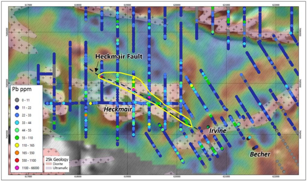
Since August 2023, De Grey has completed over 10,500 meters of aircore (AC) and reverse circulation (RC) drilling at the Becher Project, testing priority targets at the Heckmair and Lowe intrusions and the Irvine and Bonatti shear corridors.
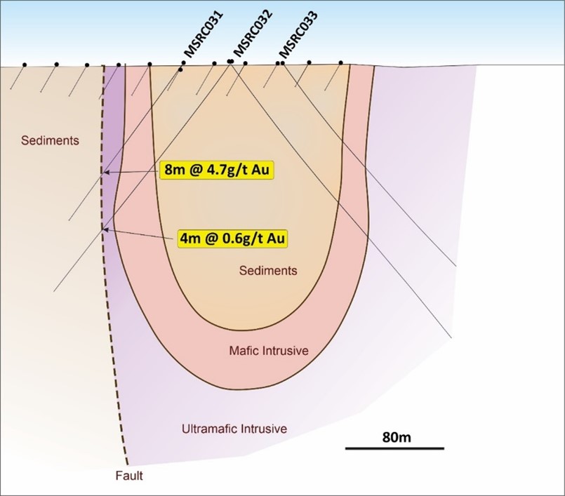
Results include an intersection of 8 meters at 4.7 g/t gold from 97 meters depth in hole MSRC0031 at the Lowe prospect. This drilling also intersected 4 meters at 0.6 g/t gold from 144 meters in hole MSRC0032. The mineralization is hosted in strongly foliated and sheared pyroxenite and gabbro.
At the Heckmair prospect, the best gold intercept was 2 meters at 2.8 g/t gold in hole MSRC0013, associated with a 1.5 km long northwest-trending fault zone.
De Grey notes that other deposits in the region demonstrate that base metal anomalism can indicate nearby gold mineralization. The company sees the Heckmair Fault as a priority target for further RC drilling in 2024.
Novo’s Egina gold belt comprises structurally complex, gold-mineralized corridors trending towards De Grey’s 12.7 million ounce Hemi gold project. Novo sees significant discovery potential across its 80 km strike length land package along this trend.
The positive drilling results at targets identified in early-stage reconnaissance work continue to highlight the prospectivity of Novo’s Pilbara gold projects. Further assay results are pending as exploration programs progress under the De Grey joint venture.
- More than 10,500 m of combined aircore (AC) and reverse circulation (RC) drilling completed by De Grey Mining (ASX: DEG) at the Becher Project in Q4 2023, as part of the Egina earn-in/JV
- RC drilling at Lowe confirmed gold mineralisation associated with a deformed intrusive sill, with a best intercept of 8 m at 4.74 g/t Au from 96 m, including 3 m @ 11.88 g/t Au from 100 m (MSRC0031)
- Follow-up RC drilling into a base metal-gold corridor previously defined by Novo at Heckmair, intersected a significant zone of base metal-gold mineralisation from the two RC holes targeting the corridor. Results include:
- 10 m @ 0.12 g/t Au, 29.7 g/t Ag, 0.3% Cu, 1.5% Pb and 1.8% Zn from 40 m (MSRC0016)
including 3 m @ 0.20 g/t Au, 59.8 g/t Ag, 0.9% Cu, 2.4% Pb and 2.2% Zn from 47 m - 24 m @ 0.2 g/t Au, 13.2 g/t Ag, 0.1% Cu, 1.0% Pb and 0.1% Zn in hole MSRC0017 from 105 m (MSRC0017)
including 6 m @ 0.48 g/t Au, 20.8 g/t Ag, 0.2% Cu, 1.4% Pb and 2.8% Zn from 105 m
- 10 m @ 0.12 g/t Au, 29.7 g/t Ag, 0.3% Cu, 1.5% Pb and 1.8% Zn from 40 m (MSRC0016)
- The base metal corridor trends WNW through the Heckmair intrusion, with broad intervals of anomalous base metals and low-level gold mineralisation mapping a fault to over 1.5 km in strike
- Resampling of anomalous gold zones from Novo’s 2023 AC program completed by De Grey, has verified broad zones of gold anomalism associated within granitic intrusions
- De Grey plans to target the Becher area with follow up AC and RC drilling to be completed at priority targets Heckmair and Lowe in 2024
The above references an opinion and is for information purposes only. It is not intended to be investment advice. Seek a licensed professional for investment advice. The author is not an insider or shareholder of any of the companies mentioned above.
Alaska Energy Metals (TSXV:AEMC) announced on Monday that its Eureka deposit at the Nikolai project in Alaska now contains one of the largest known nickel resources in the United States with contained nickel at the project at 8 billion lbs. The company published an updated mineral resource estimate showing 813 million tonnes of indicated resources grading 0.22% nickel plus 0.07% copper, 0.02% cobalt, 0.048 g/t platinum, 0.094 g/t palladium and 0.012 g/t gold. This translates to a nickel equivalent grade of 0.29% and contains 3.9 billion pounds of nickel.
Additionally, the estimate includes 896 million tonnes of inferred resources grading 0.21% nickel, 0.05% copper, 0.02% cobalt, 0.039 g/t platinum, 0.068 g/t palladium and 0.009 g/t gold for a nickel equivalent grade of 0.27% and 4.2 billion pounds of contained nickel. The tonnage of inferred resources increased 180% compared to the initial resource published in November 2023.
The 2024 resource estimate incorporated historical drill data purchased by Alaska Energy in August 2023 as well as eight new drill holes completed in 2023 totalling 4,138 metres. The mineralization covers three zones spanning 4.5 kilometres at the Eureka deposit.
A higher-grade core zone was identified within one of the zones, containing 211 million tonnes of indicated resources grading 0.34% nickel equivalent and 154 million tonnes of inferred resources at 0.33% nickel equivalent. Alaska Energy stated this zone could positively impact project economics and will be a focus for further evaluation.
The Eureka deposit is now one of the largest known nickel deposits in the United States, according to the company. The Nikolai project is located 40 km northwest of Paxson and is thought to host nickel-copper-cobalt-PGE mineralization similar to other large projects globally.
Alaska Energy Metals shares rose over 5% to C$0.29 on Monday for a market capitalization of C$20 million. The stock has traded between C$0.03 and C$0.50 over the past year.
On October 30, 2023, the company also released drill results from two additional holes at Nikolai. Hole EZ-23-003 intersected 324.6 meters grading 0.34% nickel equivalent including 0.23% nickel, 0.08% copper and 0.02% cobalt. Hole EZ-23-005 returned 356.2 meters at 0.34% nickel equivalent including 0.22% nickel, 0.08% copper and 0.02% cobalt. These holes confirmed mineralization over 600 meters of strike length with additional results pending.
The above references an opinion and is for information purposes only. It is not intended to be investment advice. Seek a licensed professional for investment advice. The author is not an insider or shareholder of any of the companies mentioned above.
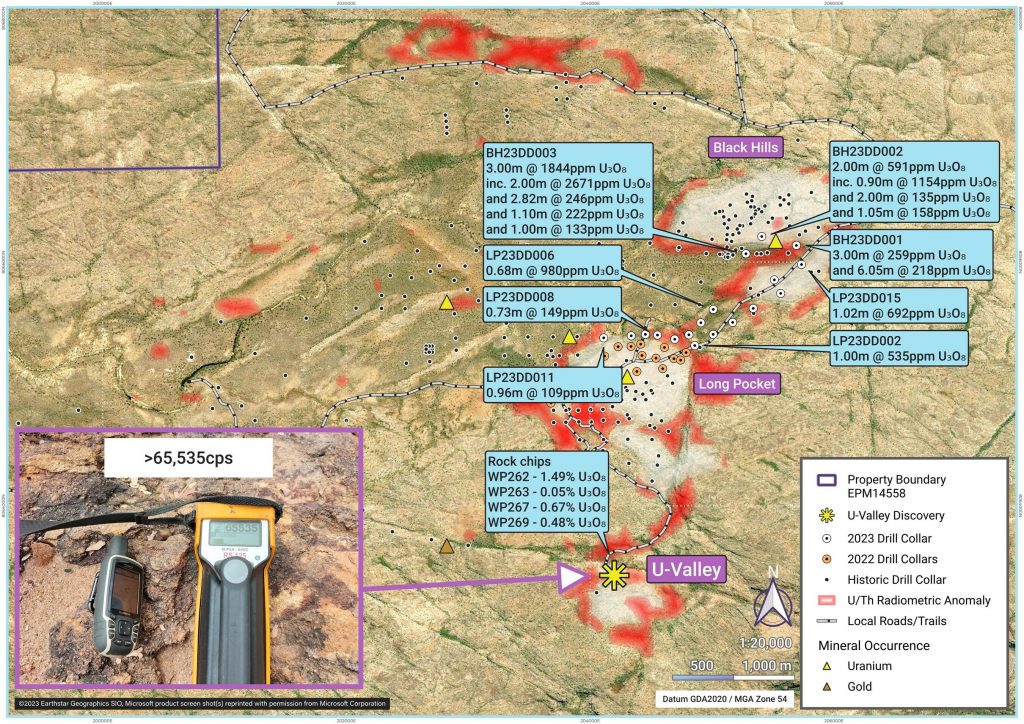
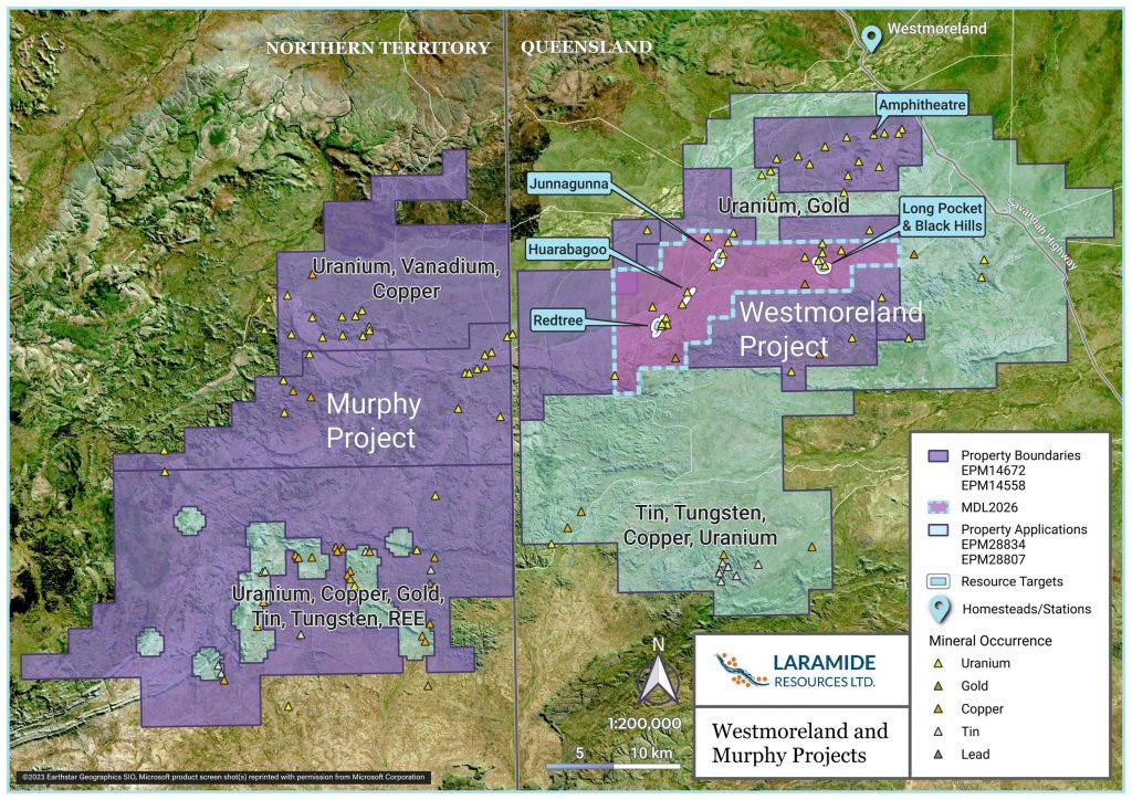
Laramide Resources (TSX:LAM) has announced the results from its 2023 drilling campaign at the Westmoreland Uranium Project in northwest Queensland, Australia. Laramide completed over 4,000 meters of diamond drilling across 40 holes at four target areas named Amphitheatre, Long Pocket, Black Hills and Huarabagoo. Assay results were recently received for the Long Pocket and Black Hills areas after extended delays at the analytical laboratories.
Laramide’s President and CEO Marc Henderson commented in a press release: “We are pleased to have received more positive results from our 2023 drilling campaign at Westmoreland, which was completed in October. The results are highly encouraging because they lend confidence that the Westmoreland Project has the potential to expand the uranium mineralisation with satellite deposits additional to the known 51.9Mlb Mineral Resources. The consistency of today’s results supports our plans to begin modelling a maiden resource at the Long Pocket area in 2024. This ‘Long Pocket area’ includes Black Hills to the north and the newly discovered U-Valley to the south. The latest results include significant grade from Black Hills which warrants further investigation and will be a priority for the 2024 field season. The 2024 exploration plans include validation and qualification of historical work, completed in the 1970s by Rio Tinto’s predecessors.”
The objective of this drilling was to explore potential extensions of known uranium mineralization at Long Pocket ahead of Laramide’s plans to establish a maiden mineral resource estimate for the area in 2024. Additional holes investigated potential extensions of mineralization towards the Black Hills uranium prospect located 1.5 km northeast of Long Pocket. Historical exploration in these areas was conducted by companies including QML, Rio Tinto and Laramide.
At the Black Hills prospect, Laramide discovered multiple new zones of uranium mineralization from previously undrilled areas at the southern end of the broad, 1.5 by 1.0 km east-west trending airborne radiometric anomaly.
The 15 exploration holes at Long Pocket tested for northerly and northeasterly extensions to the flat-lying uranium mineralization. Results from drill holes LP23DD-002, -008 and -011 presented step outs of over 100 meters from known shallow mineralization. Holes LP23DD-006 and -015 suggest the potential for a mineralized corridor towards the Black Hills prospect which requires further investigation.
Reconnaissance sampling earlier in 2023 at Laramide’s U-Valley prospect returned significant rock chip assays up to 1.49% U3O8 over two sub-parallel, approximately 200-meter-long east-west trending zones. While grab samples are discrete point data, the outcropping uranium mineralization will be a priority target for follow-up work in 2024.
- All Black Hills exploration drill holes return significant mineralisation:
-
- BH23DD001 – 3.0m @ 259ppm U3O8 from 29m depth
- BH23DD001 – 6.05m @ 218ppm U3O8 from 120.12m depth
-
-
- Including 0.98m@ 505ppm U3O8 from 120.12m
-
-
- BH23DD002 – 2.0m @ 591 ppm (0.06%) U3O8 from 209m
-
-
- Including 0.9m @ 1154ppm U3O8 from 210.1m
-
-
- BH23DD003 – 3.0m @ 1844ppm (0.18%) U3O8 from 88m
-
-
- Including 2.00m @ 2671ppm (0.27%) U3O8 from 89m
-
- Assay results from Long Pocket confirm that shallow uranium mineralisation continues to the north-east:
-
- LP23DD002 – 1.0m @ 545ppm U3O8 from 42.0m
- LP23DD006 – 0.68m @ 980ppm U3O8 from 81.0m
- LP23DD008 – 0.73m @ 149ppm U3O8 from 4.93m
- LP23DD011 – 0.96m @ 109ppm U3O8 from 21.54m
- LP23DD015 – 1.02m @ 692ppm U3O8 from 51.9m
- Rock chips from U-Valley prospect return up to 1.49% U3O8
- Long Pocket maiden resource modelling planned for 2024
Three scout holes at the Black Hills Prospect were drilled in 2023, each intercepting multiple zones of mineralisation with results including:
- BH23DD001 – 3.0m @ 259ppm U3O8 from 29m depth
- BH23DD001 – 0.98m@ 505ppm U3O8 from 120.12m
- BH23DD002 – 2.0m @ 591 ppm (0.06%) U3O8 from 209m
-
- Including 0.9m @ 1154ppm (0.12%) U3O8 from 210.1m
- BH23DD003 – 3.0m @ 1844ppm (0.18%) U3O8 from 88m
-
- Including 2.00m @ 2671ppm (0.27%) U3O8 from 89m
- LP23DD002 – 1.0m @ 545ppm U3O8 from 42.0m
- LP23DD006 – 0.68m @ 980ppm U3O8 from 81.0m
- LP23DD008 – 0.73m @ 149ppm U3O8 from 4.93m
- LP23DD011 – 0.96m @ 109ppm U3O8 from 21.54m
- LP23DD015 – 1.02m @ 692ppm U3O8 from 51.9m
|
Table 1: 2023 Long Pocket and Black Hills – Drill Collar details |
||||||
|
HOLE ID |
Prospect |
GDA94_Easting |
GDA94_Northing |
Dip |
Azimuth |
Depth (m) |
|
BH23DD001 |
Black Hills |
205691 |
8066136 |
-50 |
205 |
186.3 |
|
BH23DD002 |
Black Hills |
205407 |
8066209 |
-50 |
175 |
219.5 |
|
BH23DD003 |
Black Hills |
205277 |
8066067 |
-50 |
355 |
240.6 |
|
LP23DD001 |
Long Pocket |
204809 |
8065402 |
-80 |
355 |
51.7 |
|
LP23DD002 |
Long Pocket |
204857 |
8065314 |
-80 |
355 |
51.7 |
|
LP23DD003 |
Long Pocket |
205008 |
8065406 |
-80 |
355 |
54.8 |
|
LP23DD004 |
Long Pocket |
205168 |
8065504 |
-80 |
355 |
69.8 |
|
LP23DD005 |
Long Pocket |
204907 |
8065501 |
-80 |
355 |
57.7 |
|
LP23DD006 |
Long Pocket |
205009 |
8065611 |
-80 |
355 |
96.7 |
|
LP23DD007 |
Long Pocket |
204693 |
8065366 |
-80 |
355 |
42.7 |
|
LP23DD008 |
Long Pocket |
204551 |
8065400 |
-80 |
355 |
45.9 |
|
LP23DD009 |
Long Pocket |
204452 |
8065406 |
-80 |
355 |
45.8 |
|
LP23DD010 |
Long Pocket |
204336 |
8065394 |
-80 |
355 |
42.7 |
|
LP23DD011 |
Long Pocket |
204110 |
8065377 |
-80 |
355 |
42.7 |
|
LP23DD012 |
Long Pocket |
205337 |
8065619 |
-80 |
355 |
132.7 |
|
LP23DD013 |
Long Pocket |
205510 |
8065853 |
-80 |
355 |
78.9 |
|
LP23DD014 |
Long Pocket |
205562 |
8065742 |
-80 |
355 |
51.7 |
|
LP23DD015 |
Long Pocket |
205733 |
8065979 |
-50 |
25 |
150.5 |
|
Table 2: Black Hill and Long Pocket Significant intercepts (>100ppm U3O8) |
|||||
|
HOLE ID |
Prospect |
From |
To (m) |
Interval |
U3O8 (ppm) |
|
BH23DD001 |
Black Hills |
29.00 |
32.0 |
3.00 |
259 |
|
120.12 |
121.10 |
0.98 |
505 |
||
|
122.20 |
126.17 |
3.97 |
214 |
||
|
BH23DD002 |
Black Hills |
51.60 |
52.65 |
1.05 |
158 |
|
179.00 |
181.00 |
2.00 |
135 |
||
|
183.00 |
183.80 |
0.80 |
149 |
||
|
184.93 |
185.73 |
0.80 |
262 |
||
|
209.00 |
211.00 |
2.00 |
591 |
||
|
including |
209.00 |
209.90 |
0.90 |
1154 |
|
|
BH23DD003 |
Black Hills |
20.90 |
22.00 |
1.10 |
222 |
|
73.00 |
74.00 |
1.00 |
133 |
||
|
83.18 |
86.00 |
2.82 |
246 |
||
|
88.00 |
91.00 |
3.00 |
1844 |
||
|
including |
89.00 |
91.00 |
2.00 |
2671 |
|
|
LP23DD001 |
Long Pocket |
No significant intercepts |
|||
|
LP23DD002 |
Long Pocket |
42.00 |
43.00 |
1.00 |
535 |
|
LP23DD003 |
Long Pocket |
No significant intercepts |
|||
|
LP23DD004 |
Long Pocket |
No significant intercepts |
|||
|
LP23DD005 |
Long Pocket |
No significant intercepts |
|||
|
LP23DD006 |
Long Pocket |
81.00 |
81.68 |
0.68 |
980 |
|
86.50 |
87.22 |
0.72 |
249 |
||
|
LP23DD007 |
Long Pocket |
No significant intercepts |
|||
|
LP23DD008 |
Long Pocket |
4.93 |
5.66 |
0.73 |
149 |
|
LP23DD009 |
Long Pocket |
No significant intercepts |
|||
|
LP23DD010 |
Long Pocket |
No significant intercepts |
|||
|
LP23DD011 |
Long Pocket |
21.54 |
22.50 |
0.96 |
109 |
|
LP23DD012 |
Long Pocket |
No significant intercepts |
|||
|
LP23DD013 |
Long Pocket |
No significant intercepts |
|||
|
LP23DD014 |
Long Pocket |
No significant intercepts |
|||
|
LP23DD015 |
Long Pocket |
51.90 |
52.92 |
1.02 |
692 |
|
Table 3 – U-Valley Rock Chip sample details |
||||
|
Sample ID |
Easting |
Northing |
U3O8ppm (ME_ICP61) |
U3O8% |
|
WP269 |
204215 |
8063467 |
4870 |
n/a |
|
WP267 |
204029 |
8063220 |
6650 |
n/a |
|
WP263 |
204040 |
8063310 |
517 |
n/a |
|
WP262 |
204094 |
8063487 |
>10,000 |
1.49 |
The above references an opinion and is for information purposes only. It is not intended to be investment advice. Seek a licensed professional for investment advice. The author is not an insider or shareholder of any of the companies mentioned above.
Reunion Gold (TSXV:RGD) has announced additional positive drill results from its Oko West gold project in Guyana. The latest results come from both resource expansion drilling below the existing deposit and infill drilling within areas of inferred resources.
Rick Howes, President and CEO of Reunion Gold, commented in a press release: “I am very pleased with the results of both the resource conversion and the resource expansion drill programs, which together continue to confirm the strong levels of continuity within the open pit resource as well as the expansion of high-grade mineralization below the previously defined MRE pit shell, down to depth of 1,000 m where it remains open. This also confirms that we have significant underground potential below what is already very significant open pit potential. Once the open pit resource model is updated and the new underground resource model is complete, both the open pit and underground mine design scenarios will be evaluated as part of the Preliminary Economic Assessment (“PEA”) work already underway with G Mining Services. This work will also determine the transition depth from the open pit to underground as well as the preferred sequencing of the open pit and underground mine. We expect to release the PEA before the end of June 2024. Permitting also continues on schedule with baseline studies nearing completion and Terms of Reference for the Environmental Impact Assessment submitted to the Guyana Environmental Protection Agency for approval.”
The expansion drilling continues to confirm high-grade gold mineralization within Block 4 of the Kairuni zone, extending over 1,000 meters down-dip beyond the limits of the June 2023 mineral resource estimate (MRE) pit shell. Highlights include 14.3 meters at 8.84 g/t gold and 10.5 meters at 6.09 g/t gold within 50.1 meters at 4.10 g/t gold in hole D-360A-W2 from 1039.8 meters depth. Hole D-359-W1 intersected 24.4 meters at 7.80 g/t gold and 4.2 meters at 4.02 g/t gold within 83.5 meters at 3.06 g/t gold from 721.5 meters depth. Hole D-362A intersected 15.5 meters at 4.26 g/t gold, 4.9 meters at 6.29 g/t gold and 4.3 meters at 6.64 g/t gold within 76.0 meters at 2.27 g/t gold from 991.0 meters depth. The high-grade zone remains open at depth below 1,000 meters.
Approximately 23,500 meters of drilling below the June 2023 MRE pit will be incorporated into an updated resource estimate. Reunion Gold has also commenced a 20,000-meter infill drill program targeting deeper mineralization to upgrade resources to an indicated classification before starting a feasibility study in Q3 2024.
The infill drilling program continues to confirm continuity of mineralization and higher grades at depth within the existing MRE pit shell. Highlights include 65.9 meters at 5.12 g/t gold in hole D-353A, including 15.5 meters at 13.52 g/t gold and 8.3 meters at 4.61 g/t gold. Hole D-366 intersected 45.0 meters at 1.85 g/t gold, including 7.3 meters at 2.52 g/t gold and 4.2 meters at 3.12 g/t gold.
The updated MRE will include an open pit and an initial underground resource estimate. It will feed into a preliminary economic assessment expected by the end of June 2024.
Exploration drilling outside the MRE area has yielded several zones of anomalous gold, providing targets for further drilling. Geophysical surveys are also underway to identify additional targets across the Oko West project area. Reunion Gold plans to acquire and explore new projects in Guyana and Suriname to build its portfolio in the Guiana Shield region.
- Highlights from the resource expansion drill program, which intersected the down-dip continuation of high grade mineralization from Block 4 down to and below 1,000 meters (“m”) depth include hole D-360A-W2, which intersected 14.3 m @ 8.84 grams per tonne of gold (”g/t Au”) and 10.5 m @ 6.09 g/t, drill hole D-359-W1 which intersected 24.4 m @ 7.80 g/t Au, drill hole D-364, which intersected 14.0 m @ 7.40 g/t Au, and drill hole D-362A, which intersected 15.5 m @ 4.26 g/t Au, 4.9 m @ 6.29 g/t Au and 4.3 m @ 6.64 g/t Au (all reported using a 1.5 g/t cut-off grade).
- The high-grade zone remains fully open to further expansion below 1 km.
- The Company has now closed and handed over an updated database to G Mining Services for the preparation of an updated MRE expected to be announced by the end of February 2024.
Table 1 – Significant intervals reported from deep drilling beneath Block 4
| Hole ID | From (m) |
To (m) |
Downhole Interval (m) |
Au Grade (g/t) |
Grade x Downhole Interval (gm/t) |
ETT* (m) |
Cutoff ** (Au g/t) |
| OKWD23-350-W2 | 713.0 | 796.3 | 83.3 | 2.01 | 167 | 75.7 | 0.3 |
| inc. | 725.9 | 731.0 | 5.1 | 4.75 | 24 | 4.7 | 1.5 |
| inc. | 763.0 | 769.7 | 6.6 | 2.75 | 18 | 6.0 | 1.5 |
| inc. | 773.2 | 778.7 | 5.5 | 2.69 | 15 | 5.0 | 1.5 |
| inc. | 781.1 | 789.6 | 8.5 | 7.16 | 61 | 7.7 | 1.5 |
| OKWD23-359-W1 | 721.5 | 805.0 | 83.5 | 3.06 | 255 | 64.3 | 0.3 |
| inc. | 722.5 | 726.0 | 3.5 | 2.88 | 10 | 2.7 | 1.5 |
| inc. | 743.9 | 748.1 | 4.2 | 4.02 | 17 | 3.2 | 1.5 |
| inc. | 760.7 | 785.0 | 24.4 | 7.80 | 190 | 18.8 | 1.5 |
| OKWD23-360A-W2 | 1039.8 | 1089.8 | 50.1 | 4.10 | 205 | 44.9 | 0.3 |
| inc. | 1051.2 | 1061.7 | 10.5 | 6.09 | 64 | 9.4 | 1.5 |
| inc. | 1064.1 | 1078.3 | 14.3 | 8.84 | 126 | 12.8 | 1.5 |
| OKWD23-362A | 991.0 | 1067.0 | 76.0 | 2.27 | 172 | 68.0 | 0.3 |
| inc. | 991.0 | 994.0 | 3.0 | 1.82 | 5 | 2.7 | 1.5 |
| inc. | 1005.7 | 1010.0 | 4.3 | 6.64 | 29 | 3.8 | 1.5 |
| inc. | 1036.6 | 1041.5 | 4.9 | 6.29 | 31 | 4.4 | 1.5 |
| inc. | 1046.5 | 1062.0 | 15.5 | 4.26 | 66 | 13.9 | 1.5 |
| OKWD23-364 | 977.6 | 1022.6 | 45.0 | 3.39 | 152 | 37.1 | 0.3 |
| inc. | 897.3 | 903.0 | 5.7 | 1.90 | 11 | 4.6 | 1.5 |
| inc. | 981.4 | 985.5 | 4.1 | 3.43 | 14 | 3.4 | 1.5 |
| inc. | 999.0 | 1013.0 | 14.0 | 7.40 | 104 | 11.6 | 1.5 |
| * Estimated True Thickness (“ETT”) based on an average dip / dip direction of -65° / 095° to represent the orientation of the mineralized zone in Block 4. ETT only calculated for Blocks 1 and 4. | |||||||
| ** Significant intervals calculated using a 0.3 g/t Au cutoff, 10m minimum length and 10m maximum consecutive internal waste. Included intervals calculated using a 1.5 g/t Au cutoff, 3m minimum length and a 2m maximum consecutive internal waste. | |||||||
Table 2 – Significant Intervals reported from the MRE infill program.
| Hole ID | From (m) |
To (m) |
Downhole Interval (m) |
Au Grade (g/t) |
Grade x Downhole Interval (gm/t) |
ETT* (m) |
Cutoff ** (Au g/t) |
| OKWD23-353A | 487.0 | 491.0 | 4.0 | 2.03 | 8 | 3.6 | 1.5 |
| OKWD23-353A | 509.0 | 574.9 | 65.9 | 5.12 | 337 | 59.6 | 0.3 |
| inc. | 509.0 | 512.3 | 3.3 | 2.34 | 8 | 3.0 | 1.5 |
| inc. | 541.8 | 550.0 | 8.3 | 4.61 | 38 | 7.5 | 1.5 |
| inc. | 554.0 | 569.5 | 15.5 | 13.52 | 209 | 14.0 | 1.5 |
| OKWD23-365 | 18.0 | 43.0 | 25.0 | 0.84 | 21 | 22.9 | 0.3 |
| inc. | 35.0 | 41.5 | 6.5 | 1.90 | 12 | 6.0 | 1.5 |
| OKWD23-368 | 190.3 | 203.1 | 12.8 | 0.56 | 7 | 11.4 | 0.3 |
| OKWD23-368 | 272.3 | 283.0 | 10.7 | 0.48 | 5 | 9.8 | 0.3 |
| * Estimated True Thickness (“ETT”) based on an average dip / dip direction of -65° / 095° to represent the orientation of the mineralized zone in Block 4. ETT only calculated for Blocks 1 and 4. | |||||||
| ** Significant intervals calculated using a 0.3 g/t Au cutoff, 10m minimum length and 10m maximum consecutive internal waste. Included intervals calculated using a 1.5 g/t Au cutoff, 3m minimum length and a 2m maximum consecutive internal waste. | |||||||
Table 3 – Significant Intervals reported from Blocks 5 and 6.
| Hole ID | From (m) |
To (m) |
Downhole Interval (m) |
Au Grade (g/t) |
Grade x Downhole Interval (gm/t) |
Cutoff ** (Au g/t) |
| OKWD23-366 | 0.6 | 13.1 | 12.5 | 0.48 | 6 | 0.3 |
| OKWD23-366 | 81.0 | 126.0 | 45.0 | 1.85 | 83 | 0.3 |
| inc. | 107.1 | 114.4 | 7.3 | 2.52 | 18 | 1.5 |
| inc. | 117.6 | 121.7 | 4.2 | 3.12 | 13 | 1.5 |
| OKWD23-367 | 31.5 | 61.0 | 29.5 | 0.97 | 29 | 0.3 |
| inc. | 39.8 | 45.7 | 6.0 | 1.71 | 10 | 1.5 |
| OKWD23-369 | 0.0 | 24.5 | 24.5 | 0.84 | 21 | 0.3 |
| OKWD23-369 | 106.0 | 120.0 | 14.0 | 0.58 | 8 | 0.3 |
| OKWD24-370 | 92.0 | 109.0 | 17.0 | 0.43 | 7 | 0.3 |
| OKWD24-370 | 161.2 | 171.9 | 10.7 | 1.08 | 12 | 0.3 |
| inc. | 21.6 | 25.5 | 3.9 | 2.74 | 11 | 1.5 |
| OKWD23-356 | 190.0 | 202.0 | 12.0 | 1.56 | 19 | 0.3 |
| ** Significant intervals calculated using a 0.3 g/t Au cutoff, 10m minimum length and 10m maximum consecutive internal waste. Included intervals calculated using a 1.5 g/t Au cutoff, 3m minimum length and a 2m maximum consecutive internal waste. | ||||||
The above references an opinion and is for information purposes only. It is not intended to be investment advice. Seek a licensed professional for investment advice. The author is not an insider or shareholder of any of the companies mentioned above.
With electric vehicle adoption accelerating globally, demand for battery metals like nickel is skyrocketing. Flying Nickel Mining (TSXV:FLYN)(OTCQB:FLYNF) aims to be one of the few new nickel producers coming online in the next few years to meet this demand.
MiningFeeds spoke with Flying Nickel CEO John Lee about advancing the company’s flagship Minago nickel project in Manitoba, which he believes can reach production within 5 years to capture surging nickel demand from the EV industry.
“Nickel is a key ingredient in electric vehicle batteries. Flying Nickel aims to be the first new nickel mine in Canada within the next 5 years to supply clean nickel with a low carbon footprint to the electric vehicle industry,” said Lee.
The Minago project is located in the prolific Thompson nickel belt, the second-largest nickel district in North America. Flying Nickel is focused on permitting and development at Minago, with the goal of bringing it into production by 2025 to meet rising nickel demand from the surging electric vehicle market. According to Lee, Minago holds a number of key advantages that position it to be one of the few new nickel mines coming online in the next half-decade.
Competitive Advantages
The Minago project holds a number of competitive advantages that Lee believes will make it one of the top new nickel mines globally.
“Our project is expected to achieve full permit status in 2024 and will be one of very few projects that can get nickel out of the ground in the next 5 years,” he explained. “It has high grade 0.7% nickel in an open pit configuration, which means low technical risk and low cost relative to our peers.”
Minago is located in the Thompson nickel belt, the 2nd largest in North America, with excellent infrastructure and local support. The nearby Norway House Cree Nation is one of Flying Nickel’s largest shareholders, aligning interests between the company and the community.
Advancing Towards Production
With permitting expected in 2024, Flying Nickel is positioned to make a construction decision shortly after. “The company is in a position to make a construction decision in 2024 after full permit is granted to Minago,” noted Lee.
The recent $600k private placement provides capital to advance permitting and technical studies. A new resource estimate incorporating palladium and platinum is also underway, which Lee believes could significantly expand in-situ metals and enhance project economics.
Capturing EV Growth
Looking ahead, Lee sees Flying Nickel emerging as a major North American nickel producer as demand balloons.
“Flying Nickel aims to be a significant producer of clean nickel with a low carbon footprint in North America in 5 years. It’s one of very few new greenfield nickel deposits going into production before 2030,” he commented.
Lee believes Minago can help fill the growing global nickel deficit as EV adoption accelerates. “Nickel demand is projected to double with increasing EV adoption by 2030. Minago aims to capture that market share.”
With permitting expected soon, Flying Nickel presents a unique nickel exploration and development opportunity. “Our project is expected to achieve full permit status in 2024 and announce the construction decision, it will be one of very few projects that can get nickel out of the ground in the next 5 years.”
The above references an opinion and is for information purposes only. It is not intended to be investment advice. Seek a licensed professional for investment advice. The author is not an insider or shareholder of any of the companies mentioned above.
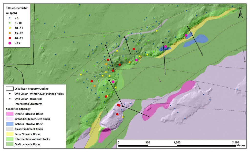
Kenorland Minerals (TSXV:KLD) has announced the start of its maiden diamond drill program at the O’Sullivan Project located in the Abitibi greenstone belt of Quebec. The Project is being explored under an option agreement with Sumitomo Metal Mining Canada Ltd.
A total budget of C$1.71 million was approved by Sumitomo for the Winter 2024 exploration program which includes up to 4,150 meters of diamond drilling in 6 initial holes. Drilling will test the Pusticamica North target identified through systematic exploration over the past three years. The drill targets were designed to test interpreted structures and coincident geophysical anomalies within the northeast trending deformation zone mapped on the property. Kenorland is operator of the Project and drilling is expected to finish by mid-February.
During 2023, Kenorland completed detailed geophysics and mapping over the Pusticamica North area. Surveys included magnetics, electromagnetic, induced polarization, lake sediment sampling, an airborne versatile time domain electromagnetic survey and mapping. The work outlined a 1.6 kilometer strike length of the deformation zone along an inflection point in the granitoid margin, coincident with interpreted east-west structure intersections. Drill holes were sited to cross chargeability and magnetic anomalies where they coincide with modelled electromagnetic plate anomalies in the deformation zone.
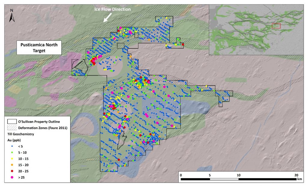
The O’Sullivan Project covers 27,979 hectares along the Casa Berardi Deformation Zone which hosts the Casa Berardi mine operated by Hecla Mining. Casa Berardi has produced over 1.9 million ounces of gold since 1988. Other major deposits along the deformation zone include the Douay deposit with 2.35 million ounce inferred resource and Nelligan with a 3.2 million ounce inferred resource. The O’Sullivan property covers 15 kilometres of strike length where the deformation zone intersects favourable volcanic host rocks.
Sumitomo can earn an initial 51% interest in the Project by spending $4.9 million on exploration within three years under the option agreement. Kenorland is the operator during the initial earn-in period. Sumitomo then has the option to earn an additional 19% by delivering a feasibility study within 7 years. Once earning 70%, Kenorland can elect to convert to a 4% net smelter royalty or retain a minority joint venture interest.
The above references an opinion and is for information purposes only. It is not intended to be investment advice. Seek a licensed professional for investment advice. The author is not an insider or shareholder of any of the companies mentioned above.
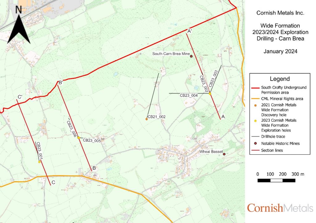
Cornish Metals Inc. (TSXV:CUSN) has announced promising results this week from the first six drill holes of its ongoing 9,000 metre Carn Brea drill programme at the South Crofty tin project located in Cornwall, United Kingdom.
Richard Williams, CEO and Director of Cornish Metals, commented in a press release: “These results confirm Cornish Metals’ model that the Wide Formation represents a new, large-scale, tin-bearing exploration target lying beneath the historically mined Great Flat Lode. The discovery of additional mineralised structures above and below the Wide Formation is a bonus. The intensity of alteration and the strength and thickness of the Wide Formation structure is similar to others in the region, and the next step for us is to define the location, orientation and extent of the high-grade pay shoots, which are typical of this style of mineralisation. The discovery of the Great Flat Lode Splay and the other new zones of high-grade tin mineralisation demonstrates the exploration upside of this area, which we view as having tremendous potential to add to our current Mineral Resource base at South Crofty.“
The Carn Brea programme aims to advance South Crofty, a formerly producing tin mine, towards a construction decision by delineating mineralization. All six initial drillholes successfully intersected the Wide Formation lode structure, characterized by strong tourmaline alteration and variable tin grades. This is consistent with other historically mined tin-bearing structures in the greater South Crofty area.
Importantly, drilling identified a newly discovered mineralized zone beneath the Great Flat Lode referred to as the “Great Flat Lode Splay,” as well as multiple high-grade, steeply dipping tin intercepts between the Great Flat Lode and Wide Formation.
The Wide Formation itself represents a significant new high-grade tin exploration target at the Carn Brea South area along the southern boundary of South Crofty’s underground mine permission area. The 14-hole, 9,000-metre campaign that started in Q3 2023 aims to define geometry and continuity of tin mineralization within the Wide Formation target, which measures 2,500 metres in strike length northeast-southwest and 525 metres in depth extent to the southeast.
To date, drilling has successfully intersected the Great Flat Lode and Wide Formation structures where predicted, confirming strike continuity of 1.6 kilometres and 525 metre depth continuity for the Wide Formation target. Two rigs are currently drilling on site, with holes 008 and 009 recently completed and more planned to further test the system along strike and improve target definition at depth.
Discovery of the Great Flat Lode Splay just beneath the Great Flat Lode was another important development from recent drilling. The splay structure is mineralized, up to 9 meters thick based on intercepts, and represents a compelling new target beginning only 280 metres below surface.
Additionally, multiple steeply dipping, high-grade tin intercepts were recorded between the Great Flat Lode and Wide Formation targets. Determining true orientations and thicknesses of these newly identified zones will require more work, but their discovery adds upside. Areas, where these high-grade structures intersect the Great Flat Lode and Wide Formation, may prove especially prospective due to increased fracturing and fluid flow.
According to Cornish Metals, the geology at its Carn Brea South exploration area matches that of the historic South Crofty mine, with metasediments overlying granite intrusives. Mineralization within the Wide Formation consists of tourmaline and disseminated cassiterite hosted in silicified, tourmaline-altered granite. The Great Flat Lode Splay also occurs as a tourmaline-rich structure with quartz and cassiterite hosted in altered granite. Neither the Wide Formation nor the newly discovered Great Flat Lode Splay have been previously mined.
Overall, the results validate the Carn Brea drill program’s objectives of expanding high-grade tin mineralization defined at South Crofty. Ongoing exploration will focus on better defining these new discoveries through step-out drilling and additional target delineation work. The company believes the Wide Formation, Great Flat Lode Splay and other steeply dipping high-grade tin zones warrant significant further study given these initial promising results.
- Wide Formation Mineralisation Confirmed Over a 1.6km Strike Length
- New Great Flat Lode Splay Discovered
- Multiple New Mineralised Structures Intersected Between the Great Flat Lode and Wide Formation
- All six drill holes intersected the Wide Formation at the expected target depths, proving the exploration model for a parallel tin mineralised structure beneath the Great Flat Lode;
- Wide Formation structure has been confirmed over a strike length of at least 1.6km, a downdip extent of at least 525m, thicknesses ranging from 1.8m – 4.8m, and remains open;
- Notable tin intercepts from the Wide Formation (Figure 2 and Figure 3), including:
- 1.21m grading 0.87% Sn in CB23_004
- 1.90m grading 0.83% Sn in CB23_006
- Notable tin intercepts from the newly identified Great Flat Lode Splay (Figure 2), including:
- 3.38m grading 1.01% Sn in CB23_002
- 1.00m grading 1.56% Sn in CB23_004
- Notable tin intercepts from multiple steeply-dipping, high-grade tin zones mainly intersected between the Great Flat Lode and the Wide Formation, including:
- 0.30m grading 7.48% Sn and 3.09m grading 1.21% Sn in CB23_001
- 1.21m grading 1.83% Sn in CB23_004
- 3.06m grading 0.93% Sn in CB23_005
- 1.17m grading 0.62% Sn in CB23_006
- A further eight drill holes are planned, testing a 2.5km strike length of the Wide Formation;
| Hole ID | From (m) | To (m) | Length (m) | Sn % | Comment |
| CB23_001 | 31.60 | 36.21 | 4.61 | 0.08 | Great Flat Lode |
| Including | 33.90 | 34.78 | 0.88 | 0.30 | |
| CB23_001 | 441.74 | 442.04 | 0.30 | 7.48 | New Zone |
| CB23_001 | 537.32 | 541.33 | 4.01 | 0.06 | Wide Formation |
| Including | 540.38 | 540.91 | 0.53 | 0.31 | |
| CB23_001 | 607.99 | 611.08 | 3.09 | 1.21 | New Zone |
| Including | 607.99 | 608.90 | 0.91 | 2.57 | |
| And | 609.86 | 611.08 | 1.22 | 0.61 | |
| CB23_002 | 204.23 | 208.20 | 3.97 | 0.32 | Great Flat Lode |
| Including | 204.23 | 206.34 | 2.11 | 0.60 | |
| And | 204.23 | 205.28 | 1.05 | 0.90 | |
| CB23_002 | 227.13 | 234.02 | 6.89 | 0.62 | Great Flat Lode Splay |
| Including | 227.13 | 230.51 | 3.38 | 1.01 | |
| And | 229.30 | 230.51 | 1.21 | 2.52 | |
| CB23_002 | 612.37 | 616.32 | 3.95 | 0.08 | Wide Formation |
| Including | 614.81 | 615.30 | 0.49 | 0.58 | |
| CB23_003 | 255.65 | 256.40 | 0.75 | 0.43 | Great Flat Lode |
| CB23_003 | 266.98 | 277.16 | 10.18 | 0.05 | Great Flat Lode Splay |
| Including | 272.35 | 273.10 | 0.75 | 0.45 | |
| CB23_003 | 473.37 | 477.81 | 4.44 | 0.26 | New Zone |
| Including | 473.37 | 474.37 | 1.00 | 0.60 | |
| CB23_003 | 643.72 | 646.53 | 2.81 | 0.06 | Wide Formation |
| CB23_004 | 198.17 | 198.87 | 0.70 | 0.01 | Great Flat Lode |
| CB23_004 | 252.89 | 259.62 | 6.73 | 0.26 | Great Flat Lode Splay |
| Including | 258.62 | 259.62 | 1.00 | 1.56 | |
| CB23_004 | 373.81 | 375.17 | 1.36 | 1.13 | New Zone |
| CB23_004 | 528.47 | 529.68 | 1.21 | 1.83 | New Zone |
| CB23_004 | 538.77 | 540.64 | 1.87 | 0.69 | New Zone |
| Including | 539.88 | 540.64 | 0.76 | 0.96 | |
| CB23_004 | 700.84 | 705.24 | 4.40 | 0.25 | Wide Formation |
| Including | 703.47 | 704.68 | 1.21 | 0.87 | |
| CB23_005 | 78.66 | 82.72 | 4.06 | 0.08 | Great Flat Lode |
| CB23_005 | 350.60 | 359.43 | 8.83 | 0.42 | New Zone |
| Including | 351.19 | 354.25 | 3.06 | 0.93 | |
| CB23_005 | 703.70 | 710.27 | 6.57 | 0.05 | Wide Formation |
| CB23_006 | 64.11 | 65.99 | 1.88 | 0.91 | Great Flat Lode |
| CB23_006 | 152.29 | 153.46 | 1.17 | 0.62 | New Zone |
| CB23_006 | 511.98 | 512.59 | 0.61 | 1.60 | New Zone |
| CB23_006 | 549.62 | 551.52 | 1.90 | 0.83 | Wide Formation |
| Including | 549.62 | 550.63 | 1.01 | 1.30 |
Table 1 – Selected drilling results from holes 1-6 at the Wide Formation target.
Note 1 – True thickness of down-hole intersections reported are expected to be approximately 70-100% of the down-hole lengths.
| Hole ID | Hole Length |
| CB23_001 | 617.7m |
| CB23_002 | 698.9m |
| CB23_003 | 731.3m |
| CB23_004 | 773.6m |
| CB23_005 | 759.3m |
| CB23_006 | 614.3m |
Table 2 – Drill hole lengths from surface to end of hole.
The above references an opinion and is for information purposes only. It is not intended to be investment advice. Seek a licensed professional for investment advice. The author is not an insider or shareholder of any of the companies mentioned above.

Brazil Potash, the leading potash development company in the country, is sponsoring the high-profile Fertilizer Latino Americano (FLA) 2024 International Conference being held this week from the 5th to the 7th of February in Miami. As a premier sponsor, Brazil Potash has an important role in the event, which has attracted over 800 attendees from across Latin America’s fertilizer industry.
CEO Matt Simpson is participating in the opening panel discussion focused on Brazil’s ambitious National Fertilizer Program. With decades of experience developing potash assets around the world, Simpson brings valuable insight into ramping up domestic potash production to reduce Brazil’s heavy imports of this key fertilizer ingredient.
Simpson will also be able to introduce Brazil Potash’s flagship Autazes Project, located in the Amazon region of central Brazil. Through its wholly-owned subsidiary, Potássio do Brasil Ltda, the company is advancing a large, shallow potash deposit near the town of Autazes. An initial economic assessment last year outlined a potential Tier 1 mine producing 4.3 million tonnes per year of potash over a 38-year lifespan.
Potash is a critical nutrient for Brazil’s mammoth agriculture industry, which must import over 96% of its current potash needs. By developing domestic potash production, Brazil can insulate itself from supply shocks and price spikes on global markets. The nation’s farmers also stand to benefit from more stable, lower potash prices over the long term.
Autazes Project for Brazil’s Fertilizer Independence
With mineralization starting at just 16 metres below surface, the Autazes Project offers some of the lowest-cost potash production potential in the industry. The deposit could supply potash to Brazilian farmers for decades to come as the country moves towards self-sufficiency.
Brazil Potash is working closely with municipal leaders in Autazes on a public consultation process as it moves towards feasibility and permitting over the next two years. The low-impact, efficient mine design includes backfilling the above-ground tailings into the mine as it advances. The company has also emphasized the critical role of potash in boosting yields on key crops like soy, corn, coffee, sugarcane, oranges, and cotton.
Conference Focused on Fertilizer’s Future in Latin America
With food security and agricultural productivity urgent priorities across Latin America, the FLA 2024 conference has attracted hundreds of stakeholders seeking strategic solutions. Over 800 attendees are taking part in panel talks, presentations, and exhibitions by top companies and experts.
The event also features Brazil’s Minister of Agriculture as a keynote speaker. Government representatives from Mexico, Peru, Argentina, Columbia and other Latin American countries are also participating.
In addition to domestic potash production strategies, conference programming covers global fertilizer price dynamics, new NPK plant investments, distribution logistics, raw material access, and more. The future of sustainable agrochemicals is another prominent theme this year.
For more information about the conference, click here.
The above references an opinion and is for information purposes only. It is not intended to be investment advice. Seek a licensed professional for investment advice. The author is not an insider or shareholder of any of the companies mentioned above.
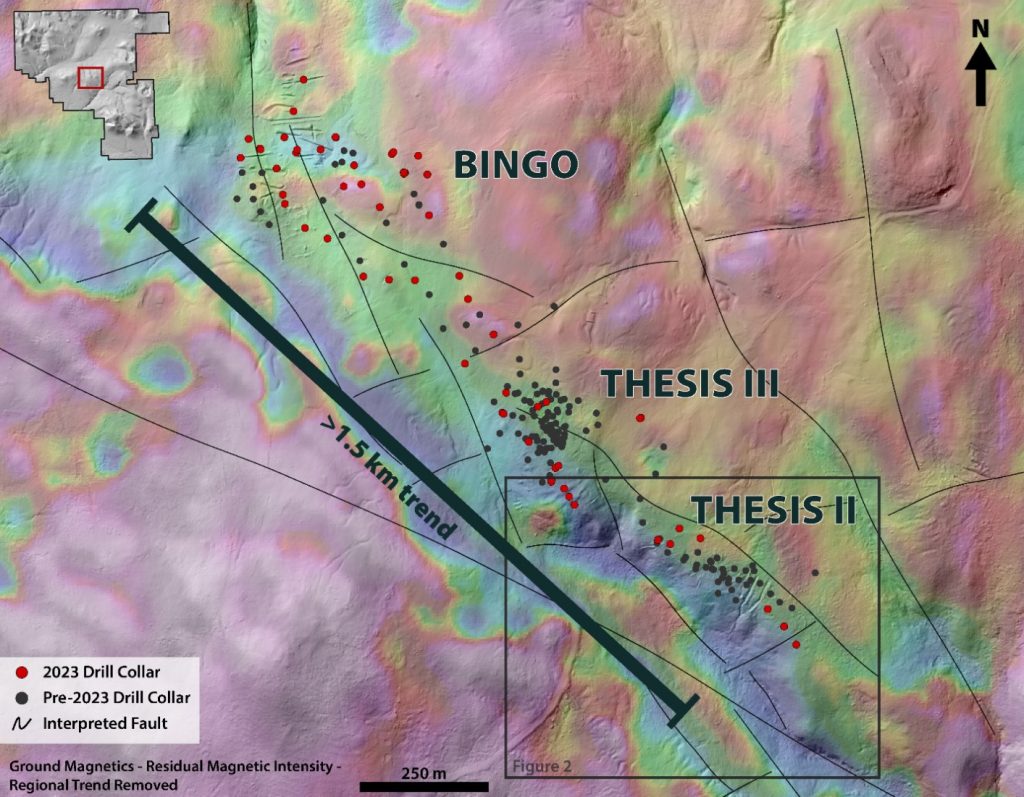
Thesis Gold (TSXV:TAU) has announced assay results from 2023 drilling at the Thesis II and Thesis III zones of its 100% owned Ranch Gold Project, located in the Toodoggone Mining District of northern British Columbia, Canada.
Ewan Webster, President and CEO, commented in a press release: “The 2023 drilling results at Thesis II and Thesis III represent yet another step towards unlocking the full potential of the Ranch Project. Our targeted strategy for the 2023 program focused on furthering our understanding of the high-grade, near-surface potential at Ranch as we progress towards a maiden resource estimate. We view this as a stepping stone in our ongoing efforts to extend the mineralization at Ranch. Today’s notable step-out headline hole of 60.00 m at 4.53 g/t Au strongly suggests that there is still much to be discovered.”
The drilling is part of a strategic plan to support the development of a maiden resource estimate at Ranch – an important milestone ahead of a forthcoming Preliminary Economic Assessment update. Together with the adjacent Lawyers Gold-Silver Project, Ranch forms Thesis Gold’s contiguous 325 km2 land package in the region.
Thesis II and III represent the southern and central zones along the multi-kilometre scale Thesis Structural Corridor, which hosts multiple mineralized domains together with the emerging Bingo zone. On a regional, district and deposit scale, mineralization occurs along intersecting NW-SE and E-W trending faults that have been mapped using magnetic surveys. These regional faults are believed to have acted as conduits for mineralizing fluids in the project’s porphyry and epithermal systems.
Recent drilling has improved the understanding of how these local faults control the geometry of the gold-mineralized bodies. One exploration hole at the southern end of Thesis II intercepted 60 meters grading 4.53 g/t gold, while a subsequent step-out hole returned only low-grade mineralization. This suggests the NE-oriented structure between the two holes may offset the mineralization to the southwest.
Altered and mineralized rock typically shows a reduced magnetic signature compared to surrounding unaltered host rock. Thesis’ technical team is developing new drill targets along the low-moderate magnetic lineaments that parallel known mineralized trends. Exceptionally broad high-grade intercepts continue to highlight the potential for expansion and new discoveries across the wider Ranch Project over the next year.
Thesis Gold is focused on unlocking the combined potential of the adjoining Lawyers and Ranch projects after its 2022 strategic merger with Benchmark Metals. A recent preliminary economic study outlined plans for a 12-year open pit operation at Lawyers yielding over 160,000 gold-equivalent ounces per year. Integrating the Ranch project aims to improve project economics further. The company’s plans include releasing a combined resource estimate in Q2 2024, followed by an updated preliminary economic assessment in Q3 2024 to showcase the full potential of the projects.
- Drilling at Thesis II was designed to test deeper mineralization identified at the end of the 2022 drilling campaign:
- 23TH2DD005 intersected 60.00 metres (m) of 4.53 grams per tonne gold (g/t Au) beginning 84 m from surface (vertical depth).
- Including 19.00 m of 10.39 g/t Au.
- 23TH2DD005 intersected 60.00 metres (m) of 4.53 grams per tonne gold (g/t Au) beginning 84 m from surface (vertical depth).
- Drilling at Thesis III returned strong near surface mineralization:
- 23TH3DD013 intersected 24.32 m of 2.93 g/t Au beginning at a vertical depth of 32 m.
- 23TH3DD017 intersected 39.90 m of 2.39 g/t Au beginning at vertical depth of 4 m.
- Confirmation and infill drilling from the 2023 season will be incorporated into an upcoming, maiden mineral resource estimate for the Ranch Project scheduled for Q2 2024.
Table 1: 2023 drill results from Thesis II and Thesis III.
| Hole ID | From (m) | To (m) | Interval (m)* | Au (g/t) | |
| 23TH2DD001 | 108.12 | 114.20 | 6.08 | 0.53 | |
| 23TH2DD002 | No Significant Results | ||||
| 23TH2DD003 | No Significant Results | ||||
| 23TH2DD004 | 130.26 | 133.00 | 2.74 | 0.83 | |
| 23TH2DD005 | 31.67 | 33.81 | 2.14 | 0.59 | |
| and | 128.28 | 129.92 | 1.64 | 44.80 | |
| and | 141.00 | 201.00 | 60.00 | 4.53 | |
| incl | 153.00 | 199.80 | 46.80 | 5.61 | |
| incl | 168.00 | 187.00 | 19.00 | 10.39 | |
| incl | 169.00 | 172.00 | 3.00 | 32.84 | |
| incl | 170.00 | 171.00 | 1.00 | 75.60 | |
| incl | 184.00 | 187.00 | 3.00 | 19.09 | |
| incl | 185.00 | 186.00 | 1.00 | 38.30 | |
| 23TH2DD006 | 170.00 | 171.00 | 1.00 | 0.61 | |
| 23TH3DD001 | 11.00 | 24.00 | 13.00 | 1.06 | |
| incl | 21.00 | 24.00 | 3.00 | 2.78 | |
| and | 33.00 | 90.00 | 57.00 | 0.76 | |
| incl | 77.00 | 78.00 | 1.00 | 7.15 | |
| and | 106.00 | 107.00 | 1.00 | 6.79 | |
| 23TH3DD003 | 106.38 | 110.00 | 3.62 | 0.45 | |
| 23TH3DD004 | No Significant Results | ||||
| 23TH3DD005 | 37.00 | 38.28 | 1.28 | 0.72 | |
| 23TH3DD006 | 44.05 | 44.70 | 0.65 | 13.85 | |
| 23TH3DD007 | 9.00 | 16.00 | 7.00 | 3.77 | |
| and | 78.53 | 97.00 | 18.47 | 0.46 | |
| 23TH3DD008 | 6.00 | 14.00 | 8.00 | 1.75 | |
| and | 39.00 | 58.96 | 19.96 | 0.66 | |
| 23TH3DD010 | 16.83 | 31.00 | 14.17 | 0.30 | |
| 23TH3DD011 | No Significant Results | ||||
| 23TH3DD012 | No Significant Results | ||||
| 23TH3DD013 | 2.96 | 5.00 | 2.04 | 0.64 | |
| and | 40.68 | 65.00 | 24.32 | 2.93 | |
| incl | 44.00 | 51.00 | 7.00 | 6.79 | |
| incl | 48.00 | 50.00 | 2.00 | 12.68 | |
| 23TH3DD014 | 119.75 | 121.00 | 1.25 | 1.29 | |
| 23TH3DD015 | 4.00 | 5.00 | 1.00 | 2.30 | |
| and | 21.00 | 33.00 | 12.00 | 0.20 | |
| and | 38.00 | 39.00 | 1.00 | 1.63 | |
| and | 55.00 | 59.00 | 4.00 | 0.47 | |
| 23TH3DD017 | 5.10 | 45.00 | 39.90 | 2.39 | |
| and | 54.08 | 60.00 | 5.92 | 0.67 | |
| 23TH3DD018 | No Significant Results | ||||
| 23TH3DD019 | 124.83 | 133.40 | 8.57 | 0.20 | |
| 23TH3DD020 | No Significant Results | ||||
| 23TH3DD021 | 286.28 | 301.34 | 15.06 | 0.63 | |
| incl | 289.67 | 292.38 | 2.71 | 1.29 | |
| and incl | 298.00 | 300.80 | 2.80 | 1.45 | |
| and | 341.20 | 352.00 | 10.80 | 0.50 | |
| 23TH3DD022 | 280.00 | 285.00 | 5.00 | 0.58 | |
| and | 309.00 | 353.00 | 44.00 | 0.88 | |
| incl | 309.00 | 339.00 | 30.00 | 1.11 | |
| incl | 323.00 | 337.00 | 14.00 | 1.80 | |
| and incl | 346.00 | 353.00 | 7.00 | 0.75 | |
| and | 360.00 | 363.07 | 3.07 | 0.35 | |
*Intervals are core length.
The above references an opinion and is for information purposes only. It is not intended to be investment advice. Seek a licensed professional for investment advice. The author is not an insider or shareholder of any of the companies mentioned above.
Carolina Rush (TSXV:RUSH) has provided new results from its recent drilling program at the Brewer Gold-Copper Project in Chesterfield County, South Carolina. The program, conducted between October 2023 and January 2024, consisted of eight core holes totalling 2,022 meters.
Layton Croft, President and CEO, commented in a press release: “Our recent drill program had three objectives: i) To define and extend the mineralization beneath the former Brewer gold mine; ii) To follow up on newly discovered mineralization in the southern Tanyard zone; and iii) To test a geophysical target ~350 meters west of the former mine. We achieved all three objectives and implemented the program as planned, which gives us useful new insights into the geometry and controls of Brewer’s gold-copper mineralization. Results have been received and reported for the first 3 holes. Initial visuals on pending holes are promising, and we anticipate more results in coming weeks.”
The most recent holes – numbered 18, 19 and 20 – accounted for 941 meters of the total program. These holes were directed eastward, testing the extension of the breccia-hosted gold and copper mineralization below the former Brewer open pit mine. Assay results from these holes have now been received and released by the company.
Four additional holes – numbered 21, 22, 23 and 25 – were drilled south of the former Brewer mine at the Tanyard target area. These holes totalled 809 meters in length. Samples from holes 21 and 22 have now been submitted for analysis at ALS Laboratories, while samples from 23, 24 and 25 are still being processed and prepared for shipment to the lab. Final assay results from all outstanding holes are expected within 4 to 5 weeks.
Carolina Rush also drilled one vertical hole (number 24), located approximately 350 meters west of the former Brewer mine. This hole was targeting a large geophysical anomaly identified through prior surveys.
The Brewer Project is located on a 397-hectare former mine property, just 17 kilometres from the operating Haile Gold Mine along the same mineralized trend. Carolina Rush Corporation holds exclusive rights to explore, lease and purchase the Brewer property. The company also recently signed agreements to explore historic gold mine sites in Randolph County, North Carolina.
Patrick Quigley, Senior Geologist and Exploration Manager, also commented: “Hole 21 was the first hole following up on Hole 15, the new southern gold-copper zone we discovered in 2021 (62.40 meters @ 1.03 g/t Au and 0.15% Cu from 44.60 meters). The photos below in Figure 3 highlight characteristics of the mineralized breccia in Hole 21, including intense sulfide replacement and notable concentrations of copper sulfides, which are very encouraging. This newly discovered southern Tanyard zone is located near surface and near the former mine, providing further testament to how under-explored the Brewer property is. We still have a lot to learn about this new zone, and we believe there is a lot of potential in this overlooked area.”
- Holes 18, 19 and 20 (941 meters) were drilled under the former mine area (see January 4, 2024 news release for Hole 18 and Hole 19 results)
- Hole 20 (B23C-020) intersected 65.95 meters of 0.50 g/t Au, including 29.5 meters of 0.79 g/t Au and 11.98 meters of 1.38 g/t Au and 0.11% Cu, from 163.5 meters depth, extending the mineralized breccia 75 meters below the former mine in this area (see Table 1 for complete results).
- Holes 21, 22, 23 and 25 (809 meters) were drilled south of the former mine, in the Tanyard zone, following up on a new zone of gold-copper mineralization (Hole 15) discovered by Rush in 2021.
- All four holes encountered strongly altered and locally mineralized lithologies that demonstrate the prospectivity of the Tanyard target area.
- Most notably, Hole 21 (B23C-021) intersected a ~30-meter interval of breccia-hosted mineralization from 130 meters depth, including a 9-meter-wide zone of massive sulfides, and the presence of copper sulfides (see photos in Figure 3).
- Assays for Holes 21, 22, 23, 24 and 25 are pending. Samples have been and will be submitted to ALS’s sample preparation laboratory in Twin Falls, ID, and results of gold and multi-element analyses are expected from mid-February onward.
Table 1: Results for Hole 20
| Hole ID | From (m) | To (m) | Interval (m) | Au (g/t) | Cu (%) |
| B23C-020 | 98.86 | 113.30 | 14.44 | 0.41 | <0.10 |
| Incl. | 99.86 | 105.00 | 5.14 | 0.67 | 0.11 |
| And | 163.50 | 229.45 | 65.95 | 0.50 | <0.10 |
| Incl. | 171.00 | 200.50 | 29.50 | 0.79 | <0.10 |
| Incl. | 188.52 | 200.50 | 11.98 | 1.38 | 0.11 |
The above references an opinion and is for information purposes only. It is not intended to be investment advice. Seek a licensed professional for investment advice. The author is not an insider or shareholder of any of the companies mentioned above.
If you would like to receive our free newsletter via email, simply enter your email address below & click subscribe.
 Follow us on Twitter
 Become our facebook fan
CONNECT WITH US
Tweets
Tweet with hash tag #miningfeeds or @miningfeeds and your tweets will be displayed across this site.
MOST ACTIVE MINING STOCKS
Daily Gainers
 CMC Metals Ltd. CMC Metals Ltd. |
CMB.V | +900.00% |
 Eden Energy Ltd Eden Energy Ltd |
EDE.AX | +200.00% |
| GoviEx Uranium Inc. |
GXU.V | +42.86% |
| Eagle Nickel Ltd. |
ENL.AX | +41.67% |
| Citigold Corp. Limited |
CTO.AX | +33.33% |
| Mount Burgess Mining NL |
MTB.AX | +33.33% |
| Exalt Resources Limited |
ERD.AX | +31.94% |
| Casa Minerals Inc. |
CASA.V | +30.00% |
| Cariboo Rose Resources Ltd |
CRB.V | +28.57% |
| Belmont Resources Inc. |
BEA.V | +28.57% |